


Minas de San José sits in the central plateau of Teide National Park, a high pumice plain above 2,300 metres where pale ash fields meet stark lava flows. Right beside the TF-21 road, a small mirador and parking pocket mark a strategic node in the park’s trail network. Several official PNT routes either start, end or traverse this area, making Minas de San José a useful base for half-day hikes and crossing routes between Montaña Blanca and the great trench of Siete Cañadas. This guide focuses on those signed paths so hikers can choose a route that fits their time, fitness and transport options, while always confirming the latest official data and regulations before setting out.
Get the latest updates straight to your inbox!
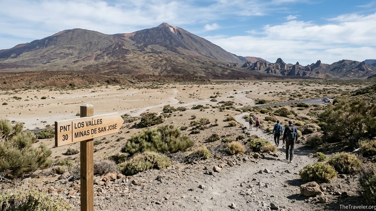
Minas de San José in Teide’s Trail Network
Minas de San José is an extensive pumice and ash plain on the north side of the TF-21, roughly in the middle of Teide National Park’s caldera. The mirador area is identified in official materials as a viewpoint with panoramic vistas of Teide, Pico Viejo and the northern valleys. The pale, eroded pumice fields here are the result of explosive eruptions from nearby domes such as Montaña Blanca, and today they form one of the most characteristic landscapes of the park.
Next to the mirador, a small roadside parking pocket on the TF-21 provides space for only a limited number of vehicles. From this area and its immediate surroundings, several official PNT trails either begin or pass close by. The two most relevant for hikers focused on Minas de San José are PNT 30 Los Valles, which descends towards the long traverse of Siete Cañadas, and PNT 39 B Montaña Blanca – Minas de San José, which crosses the pumice fields between the Montaña Blanca parking and the Minas area. There may also be very short signed connectors between the mirador and nearby tracks or viewpoints, but these function as local links rather than independent long-distance hikes.
Because the Teide trail network, numbering and management have been revised in recent years, hikers and editors should always cross-check any route name and number with the current official trail list and maps before publication or travel. The park authority and the Spanish national parks service maintain updated inventories that now reference 40-plus official PNT itineraries, and details such as length, estimated time and permitted uses can be adjusted when new management plans or conservation measures are approved.
PNT 30 Los Valles: Minas de San José to Siete Cañadas
The route commonly described as PNT 30 Los Valles is the principal descent from Minas de San José into the trench of Siete Cañadas. According to current official information, the trailhead is signposted on the south side of the TF-21, close to kilometre point 38 to 38.5, opposite or near the Minas de San José mirador. Hikers normally park in the small lay-by at the mirador and then cross carefully to the signed starting post, which carries the route number and name along with basic data such as approximate time and distance.
From the road, PNT 30 begins by crossing gently sloping pumice terrain, with pale ash and scattered lava blocks underfoot. Waymarking follows the park’s usual style for official paths, with vertical posts at the start and key junctions, and painted flashes or small cairns reinforcing the line in open sections. Early on, views open across the central plateau towards Teide’s cone, while behind you the mirador and road quickly shrink in the vast high-altitude plain. The descent is generally moderate, but hikers will notice the combination of loose pumice and small stones that demand attention to footing.
As the path continues, it threads between low pumice ridges and darker lava tongues, steadily losing height towards the Siete Cañadas trench. Vegetation is dominated by high-altitude shrubs such as Teide broom, with little shade at any time of day. Official descriptions classify this itinerary as an easy to moderate walk, suitable for hikers with basic experience in uneven volcanic terrain. The route eventually approaches the area around Risco Verde and the Cañada de Las Pilas, where it meets the long-distance path 4 Siete Cañadas, which runs east to west across the interior of the caldera.
Exact figures for length, elevation loss and time can vary slightly between official brochures and maps. Typically, the park suggests a walking time on the order of several hours for the full PNT 30 itinerary, with a steady but not extreme descent from the Minas plateau down into Siete Cañadas. Because some official documents are being updated in parallel with new management rules, writers should present any figures as approximate and confirm the latest values directly in the most recent park trail sheets or digital map before publishing.
PNT 39 B Montaña Blanca – Minas de San José
The official variant linking Montaña Blanca and Minas de San José currently appears in park materials as PNT 39 B Montaña Blanca – Minas de San José. This is a mid-altitude traverse that allows hikers to cross between the busy Montaña Blanca parking, used for ascents towards Teide, and the quieter pumice plains and mirador at Minas de San José. It stays on the upper plateau rather than climbing to the summit area, and is therefore distinct from the demanding PNT 7 route to La Rambleta.
At the Montaña Blanca end, hikers usually start from the main parking area on the TF-21, where the trail posts indicate both the ascent path towards Teide and the link that skirts the base of Montaña Blanca’s domes. The PNT 39 B section follows a path across extensive pumice fields and lava flows, generally trending east towards Minas de San José. Underfoot, the surface is a mixture of fine, very loose pumice and rough, abrasive lava fragments, which can be tiring despite modest gradients. Altitude remains well above 2,000 metres, so the air is thin and UV exposure strong.
Official documentation for PNT 39 B indicates a distance in the region of 3 kilometres between Montaña Blanca and Minas de San José, with a relatively small height difference compared with summit routes and an estimated walking time of around one hour at a steady, unhurried pace. Minor discrepancies between different official sources and map scales are possible, so figures should be quoted as approximate and verified against the current park map or trail sheet before publication. For fit walkers already acclimatised to the altitude, this is generally considered an easy itinerary in terms of technical difficulty, provided they are comfortable on loose pumice.
In practice, hikers use PNT 39 B in several ways. Some opt for a simple out-and-back from either Montaña Blanca or Minas de San José, turning around when they reach the opposite trailhead and returning to their start point and parked vehicle. Others arrange a vehicle shuttle, leaving one car at each end to walk the traverse only once in a point-to-point fashion. Experienced walkers sometimes integrate PNT 39 B into longer loops that combine sections of the Montaña Blanca ascent path, parts of Siete Cañadas, or viewpoints along the TF-21, but these more complex combinations require careful planning and should respect current access limits and any permit or fee requirements applied to specific trails.
Other Short Connectors Involving Minas de San José
Apart from PNT 30 Los Valles and PNT 39 B Montaña Blanca – Minas de San José, there may be short signed connectors and local paths starting at the Minas de San José mirador. Some official viewpoint guides mention local walks between Minas de San José and nearby features such as Montaña Rajada or other small domes. These segments typically serve to link the mirador with nearby tracks, minor summits or alternative viewpoints, rather than forming primary routes across the park.
Such connectors are usually short in distance, often taking less than an hour out and back, and mainly intended as scenic strolls for visitors who stop at the mirador for a brief exploration of the pumice fields. They are signposted in the same style as other official park paths, but may not always have a distinct PNT number if they are considered part of a larger itinerary. Because small segments and naming conventions can change as new interpretive materials are produced, writers should double-check any reference to these connectors, including whether they are currently open, signposted and listed as independent trails or simply variants within a broader route.
It is important to clearly separate these short walks and connectors from longer, more demanding summit or high-level routes such as those leading to the top of Teide or traversing remote ridge systems. Those high-difficulty routes generally do not pass through Minas de San José, even if they begin from nearby road access points like the Montaña Blanca parking. For this article, the focus remains on itineraries that clearly start, end or pass through the Minas de San José plateau itself.
Regulations, closures and naming around connectors can be particularly dynamic when restoration projects are underway in pumice extraction sites or fragile habitats. If any local path near Minas de San José passes through zones under active restoration, editors should either omit it or explicitly state that its status depends on current conservation work and must be checked against the latest information notices provided by the park authority.
Planning, Difficulty and Route Comparison
Choosing the right hike from Minas de San José depends on a realistic appraisal of distance, elevation, terrain and personal fitness. PNT 39 B between Montaña Blanca and Minas de San José is generally the shortest and least steep of the main routes, with a distance of around 3 kilometres one way, gentle gradients and a typical walking time of about one hour. The main challenge is the loose, highly reflective pumice, which can make each step feel less efficient than on compact dirt trails, and the altitude, which can leave sea-level visitors short of breath.
PNT 30 Los Valles is longer and involves a more sustained descent from the Minas plateau into the trench of Siete Cañadas. Although gradients are moderate, the cumulative elevation loss and the same loose volcanic surfaces require better stamina and ankle stability. Depending on the exact section walked and the chosen starting point, hikers should anticipate a half-day commitment, especially if they include time for breaks and photography at viewpoints such as Risco Verde or the open-floor of Cañada de Las Pilas. Returning to the starting point may require either retracing the route uphill or using another official trail, which adds to the total effort.
Other short connectors around Minas de San José tend to be brief out-and-back strolls, often under one hour total. These are best suited to visitors with limited time, those adjusting to altitude or travelers who simply want to experience the pumice landscape without committing to a full hike. Despite their modest length, the same environmental factors apply: strong sun, exposure to wind and a complete lack of services or shade on the trail.
For publication and trip planning, it can be helpful to summarise key parameters for each Minas-related route in a simple comparison table that lists distance, estimated time, approximate elevation change, difficulty rating and main scenic highlights, using official figures where available. Where official sources disagree slightly, the table should present ranges rather than a single precise number and note that different maps or brochures round figures differently. Before finalising any table or itinerary description, editors should confirm the current data with the latest park trail sheets or digital maps produced by the responsible authorities.
Access, Parking and Public Transport
Access to Minas de San José is via the TF-21, the main road that crosses Teide National Park from north to south. Drivers approaching from La Orotava in the north or Vilaflor in the south follow this scenic highway across the caldera. The Minas de San José mirador is signposted along the roadside, and the parking area consists of a small lay-by directly adjacent to the viewpoint. Spaces are limited and, especially in high season and on clear weekends, the lay-by can fill by late morning.
Because of this, it is sensible to plan hikes that start or end at Minas de San José for early morning or later in the afternoon, when parking pressure eases and lighting is especially beautiful for photography. However, winter days at this altitude are short, and temperatures fall rapidly after sunset, so hikers should avoid starting late unless they can complete the route in full daylight. As at other roadside viewpoints in the park, parking is free of charge, but subject to any episodic restrictions that local authorities might impose during special operations or crowded astronomical events.
Regular public bus access within the park is limited. The island bus company operates daily services into Teide National Park from Puerto de la Cruz and from the south of the island, but these routes have few stops and operate on one round trip per day in many seasons. There is generally no scheduled stop directly at Minas de San José, and walking along the fast TF-21 to or from remote stops is unsafe and not recommended. As a result, the Minas-based trails are most practical for hikers with a private or rented vehicle, or those joining an organised excursion that includes transfers.
In recent years, authorities have occasionally put in place special public transport operations that temporarily restrict private cars on certain dates or time windows, particularly during major meteor showers or astronomical events when crowds and traffic can become unmanageable. During such operations, access to areas along the TF-21, including Minas de San José, may depend on using dedicated shuttle buses. These special measures are time-limited and announced in advance, so hikers planning visits around those dates should consult the most recent notices from local institutions and the park authority before relying on private car access.
Current Regulations, Closures and Environmental Rules
Teide National Park operates under a detailed management plan that sets rules for trail use, conservation zones and visitor behaviour. In the past few years, several resolutions have addressed issues such as temporary closures of summit trails after storms, re-opening of paths with safety improvements, and new fee structures or permits for high-demand routes. Some measures specifically exempt or include certain numbered trails, with lists that can be revised as conditions change. Because of this, hikers and writers must treat any regulatory summary as provisional and verify the status of each trail segment at the time of writing or before hiking.
While routes like PNT 30 and PNT 39 B are not among the most regulated summit accesses, they still fall within the overall framework of park rules. These include staying on signposted trails, respecting any temporary closures after severe weather, and observing seasonal or event-related capacity limits if they are extended to additional itineraries. In winter, heavy snow or ice can lead to partial closure of certain routes or mirador access for safety reasons, and high winds can result in broader access advisories, even on lower trails.
Camping and overnight stays within Teide National Park are tightly controlled. Historically, camping outside designated facilities has been prohibited, and overnight bivouacs have been subject to permit regimes at specific refuges or zones. However, overnight regulations and the status of refuges and mountain huts have been in flux, especially since some facilities have undergone renovation or management changes. Before stating any specific rule about camping or bivouacs around Minas de San José or elsewhere in the park, editors must confirm the current overnight policy directly with the official park management or the latest regulatory documents, and either include the verified rule or refrain from detailing overnight options.
In addition to access and camping rules, there are park-wide conduct regulations. These typically include prohibitions on collecting rocks or plants, leaving the marked paths, lighting fires, smoking on trails and miradores, and flying drones without explicit authorisation. Recent decisions have reinforced the ban on smoking throughout the park to reduce fire risk, including on trails, parking areas and open viewpoints. As management responsibilities have been updated and local institutions introduced new conservation tools such as visitor fees on certain routes, details may change. Editors should therefore point readers to the need for a final check of the latest official regulations shortly before their trip.
Safety, Weather and High-Altitude Conditions
Even though routes from Minas de San José are not technical mountaineering itineraries, they take place at high altitude and in an exposed volcanic environment. Elevations along PNT 39 B and the upper part of PNT 30 sit well above 2,000 metres, which can cause mild altitude-related symptoms such as shortness of breath, fatigue or light headache in some visitors, especially those who travel from sea level and start hiking immediately. A conservative pace, regular pauses and good hydration help many walkers adapt more comfortably.
Weather conditions on Teide’s plateau are famously changeable. Clear mornings can turn cloudy and windy by midday, and in winter months cold fronts can bring snow, ice and freezing temperatures. Recent storms have led to snowfalls that temporarily closed roads and triggered orange-level weather alerts in parts of the Canary Islands. Windchill can be severe on exposed pumice plains like Minas de San José, where there is virtually no natural shelter. Hikers should always check same-day weather forecasts and park alerts before departure and be prepared to abandon or alter plans if conditions deteriorate.
Strong solar radiation is another key safety factor. At these altitudes, UV levels are high even on cool days, and the pale pumice surface reflects additional light upwards. Suitable sun protection for skin and eyes is essential, including high-factor sunscreen and sunglasses with good coverage. Lightweight but long-sleeved clothing, a brimmed hat or cap and sufficient water for the planned duration are strongly recommended, although exact quantities should be adapted to individual needs, weather and route length.
Underfoot, the combination of loose pumice, fine gravels and sharp, abrasive lava fragments makes sturdy footwear with good grip highly advisable. Trail shoes or boots designed for rocky terrain help reduce the risk of slips, twisted ankles and discomfort from sharp stones. Because the terrain is almost entirely open and devoid of shade or services, hikers should start their routes with all necessary supplies, including water, snacks, basic first aid and layered clothing. Occasional reports of increased seismic activity in the Teide area do not imply an imminent eruption for visitors, but they can prompt authorities to adjust recommendations or access in certain zones, which is another reason to consult official alerts close to the hiking date.
Wayfinding and Protecting the Pumice Landscape
Teide National Park’s official PNT network is generally well signposted. At the trailheads for PNT 30 Los Valles and PNT 39 B Montaña Blanca – Minas de San José, hikers can expect vertical posts with the route number, name, basic data and arrows indicating direction. Additional posts, cairns and waymarks guide the way where paths cross open pumice plains or intersect with other official trails such as the long Siete Cañadas traverse. Despite this, visibility can deteriorate in cloud, and long stretches of similar-looking pumice make it easy to drift off-route if not paying attention.
For this reason, hikers should not rely only on visual memory of the path or line-of-sight landmarks. Downloading offline maps from reputable sources before entering the park, or carrying official trail PDFs or printed maps obtained from visitor centres or the park’s information services, provides a useful backup. GPS apps can help confirm position when the landscape appears repetitive, but battery management is important in cold or very hot conditions, and devices should not replace basic trail sense and attention to signposts.
The pumice crust and ash fields around Minas de San José are among the park’s most fragile environments. Off-trail wandering, even by a small number of people, can quickly leave scars that take many years to fade in this high-altitude climate. In some areas, restoration projects aim to heal scars from past pumice extraction or old vehicle tracks, and these zones may be fenced or clearly signed as closed to public access. Hikers should never step into such areas or cut new shortcuts across open terrain, even if the surface appears solid.
Staying on the marked path is therefore both a safety measure and a way of protecting Teide’s geological heritage and fragile high-mountain flora. Group leaders should set an example by following signposted lines, and photographers can usually find excellent vantage points from within the trail corridor without trampling untouched pumice or approaching steep, unstable edges. Leaving no litter, keeping noise levels low and respecting other visitors completes the low-impact ethos that the park authority increasingly emphasises in its visitor information.
Recommended Example Hikes from Minas de San José
For casual visitors or those adjusting to the altitude, a short one-hour out-and-back stroll from the Minas de San José mirador onto the pumice plain is an attractive option. Starting from the small parking lay-by, walkers follow the initial section of PNT 30 Los Valles or a signed local connector for as long as they feel comfortable, then simply return the same way. This offers big-sky views of Teide and the surrounding caldera without committing to long distances or complex logistics. It suits reasonably mobile travelers with basic hiking footwear who want a taste of the volcanic landscape.
A more substantial half-day outing combines Minas de San José with a longer segment of PNT 30 Los Valles. Starting at the mirador parking, hikers descend along the official trail until they reach the junction with Siete Cañadas near Risco Verde or the Cañada de Las Pilas area. After a rest and exploration along the main trench path, they can either retrace their steps uphill to Minas de San José or, if they have arranged transport and are familiar with the network, continue along Siete Cañadas to another trailhead or parking area. This route is best for moderately fit hikers with some experience in volcanic or mountain terrain.
For active hikers looking for a longer but technically straightforward traverse, linking Montaña Blanca and Minas de San José via PNT 39 B is a rewarding choice. One option is to park at Montaña Blanca, walk across the pumice fields to Minas de San José, enjoy the views from the mirador, and then return by the same route. Another is to arrange a vehicle shuttle, leaving one car at each end and walking the traverse in a single direction, which reduces total time on foot. This suits hikers comfortable with loose surfaces and exposure at altitude who want to experience the extensive pumice fields without the strenuous elevation of summit ascents.
In every case, distances, durations, access details and regulations should be checked against the latest official information shortly before publication or travel. The Teide trail network, management responsibilities, permit systems and conservation measures have all been evolving, and only the most recent park documents and notices can confirm the exact status of PNT 30 Los Valles, PNT 39 B Montaña Blanca – Minas de San José and any short connectors involving Minas de San José at the time of a planned hike.