


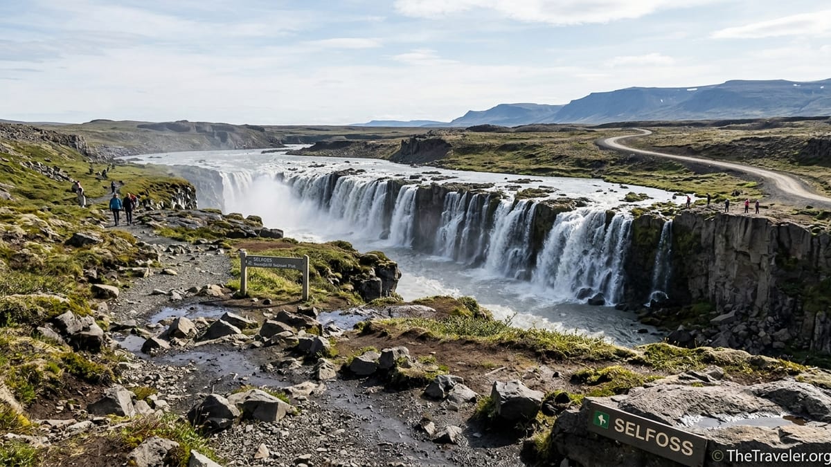
Selfoss waterfall in North Iceland sits a short walk upstream from Dettifoss in the Jökulsárgljúfur area of Vatnajökull National Park, far from the town of Selfoss in South Iceland. Most visitors reach it by driving the Ring Road (Route 1) in North Iceland, then turning onto either the paved west side access road (Route 862) or the rougher east side road (Route 864). This guide focuses on the practical logistics of getting there from Reykjavík, Akureyri, Lake Mývatn and Húsavík.
Get the latest updates straight to your inbox!
Understanding the Location and Access Roads
Selfoss waterfall is part of the Jökulsá á Fjöllum river canyon in Northeast Iceland, within the Jökulsárgljúfur section of Vatnajökull National Park. It lies only a few hundred metres upstream from Dettifoss, one of Iceland’s most powerful waterfalls, and is usually visited on the same walk. Both falls are signposted from the main Dettifoss parking areas rather than having separate road approaches.
Access for drivers is from Iceland’s Ring Road, Route 1, which runs across North Iceland. From this main artery, you either turn onto west side Route 862 (Dettifossvegur) or east side Route 864 (Hólsfjallavegur). Current official and regional tourism information describe Route 862 as a paved road from Route 1 to the main Dettifoss and Selfoss car park on the west bank, while Route 864 remains a gravel road on the east bank that is usually only passable in summer and can be very rough in places.
Because road classifications and surface conditions can change over time as sections are upgraded or maintained, travelers should check the latest information on the Icelandic Road and Coastal Administration website and local tourist offices shortly before their trip. Route 862 is generally suitable for regular non 4x4 rental cars in summer when conditions are good. Route 864, although not classified as an F road, is gravel and can be potholed or corrugated, so some rental companies discourage or restrict its use. It is important to confirm permitted road types in your rental contract before choosing the east side approach.
Walking paths to Selfoss leave from both the west and east Dettifoss parking areas. The west side, reached via Route 862, has become the standard approach for most visitors because of the paved access road, larger car park and well marked paths to viewpoints over both Dettifoss and Selfoss. The east side via Route 864 offers impressive views but can involve rougher walking and more variable trail conditions.
From Reykjavík: Long Distance Planning on the Ring Road
The distance from Reykjavík to the Dettifoss and Selfoss area is significant. Driving routes and recent travel guides indicate a distance of roughly 520 to 540 kilometres by road via North Iceland, with non stop driving times commonly estimated at around seven hours in good summer conditions. That assumes steady highway speeds, no major roadworks and no sightseeing stops, which is rarely realistic for visitors.
The most direct route from Reykjavík for most travelers is to follow the Ring Road, Route 1, north and east. This takes you from Reykjavík through the capital region tunnels and along the west coast, then inland past Borgarnes and over Holtavörðuheiði towards North Iceland. From there, Route 1 passes Blönduós and Skagafjörður, then approaches Eyjafjörður and Akureyri. Continuing east, Route 1 crosses the interior high plateau toward the Lake Mývatn area and the village of Reykjahlíð. East of Lake Mývatn, you remain on Route 1 for roughly another 20 to 30 kilometres before the signed junction with Route 862 north to Dettifoss west side.
An alternative, longer Ring Road route from Reykjavík runs east and then north via South and East Iceland before eventually looping back to the Dettifoss area from the east. This southern route passes the South Coast highlights and the town of Höfn before turning inland through East Iceland, then eventually meeting the northeastern section of Route 1 between Egilsstaðir and Lake Mývatn. From there you can still turn onto Route 862 or 864 to reach the falls. This direction is usually chosen as part of a full Ring Road loop rather than a focused trip to Selfoss waterfall.
Because of the long distances involved and the potential for variable weather, most visitors do not attempt Selfoss and Dettifoss as a day trip from Reykjavík. Even in high summer, a return journey would involve well over 10 to 14 hours of actual driving once fuel and food stops are included, leaving little margin for sightseeing or unexpected delays. It is more practical to incorporate Selfoss into a multi day Ring Road or North Iceland itinerary, overnighting in Akureyri, Lake Mývatn or Húsavík. When planning, treat estimated driving times as best case. Strong winds, heavy rain, fog, roadworks or temporary closures can add hours to a day, especially outside the summer months.
From Akureyri: North Iceland Base for a Long Day Trip
Akureyri is the main regional hub in North Iceland and a popular base for visiting both Lake Mývatn and the Diamond Circle, which includes Dettifoss and Selfoss. Recent distance tables and regional tourism materials put the drive from Akureyri to the Dettifoss west side car park via Route 1 and Route 862 at roughly 150 kilometres one way, usually quoted as about one hour 45 minutes to a little over two hours of non stop driving under summer conditions.
To reach Selfoss from Akureyri, leave town eastwards on Route 1, following signs toward Lake Mývatn and Egilsstaðir. The road climbs out of Eyjafjörður, crosses the Vaðlaheiði area, and continues across the highlands before descending toward the Mývatn region. You pass key junctions for local roads, then reach the Lake Mývatn area and the village of Reykjahlíð. Continue east on Route 1 past Mývatn; roughly 20 to 30 kilometres beyond the lake, watch for clear signage indicating the turnoff to Dettifoss via Route 862 on your left (north). The intersection is signposted for Dettifoss and usually also marked with icons for a waterfall and Vatnajökull National Park.
Once on Route 862, follow the paved road north toward the Dettifoss and Selfoss parking area. Current tourist information describes this stretch as fully asphalted between Route 1 and the main parking lot, which makes it the preferred access for most standard rental cars in summer. At the end of the road you will find parking, basic facilities and marked trails to Dettifoss and upstream to Selfoss. In total, the drive from Akureyri to the car park is commonly treated as a realistic long day trip, especially when combined with brief stops at Goðafoss and Lake Mývatn.
In winter and early spring, conditions between Akureyri and Mývatn can be wintry, with snow, ice and occasional closures on mountain passes. Road 862 may not be cleared daily in mid winter, and local tourism sources note that its opening can be intermittent outside high season. Confident drivers in well equipped cars sometimes make the trip in settled winter weather, but it is essential to check live road conditions, surface warnings and weather forecasts on the day of travel. When the combination of dark hours, ice and wind looks challenging, guided tours from Akureyri or Lake Mývatn that include Dettifoss and Selfoss are often the safer choice.
From Lake Mývatn and Reykjahlíð: The Most Convenient Launch Point
Reykjahlíð and the Lake Mývatn area form the closest major accommodation base to Selfoss waterfall, and for many independent travelers this is the most convenient starting point. Regional route guides indicate that from the eastern side of Lake Mývatn it is around 25 kilometres east on Route 1 to the junction with Route 862, followed by roughly 23 to 25 kilometres north on Route 862 to the west side Dettifoss and Selfoss parking. Under good summer conditions, the drive from Reykjahlíð to the car park typically takes about 50 to 60 minutes without stops.
From the village of Reykjahlíð, head east on Route 1 in the direction of Egilsstaðir. The road climbs past the geothermal area near Námafjall and continues across a barren plateau. Stay on Route 1 and watch for the clearly marked sign for Dettifoss and Route 862 on your left. Turn north onto Route 862, then follow this paved road all the way to the signed parking for Dettifoss. Because the junction comes in an open, sparsely populated landscape, some drivers find it helpful to track the approximate distance from Reykjahlíð on their odometer so they can anticipate the turn.
From the west side parking, Selfoss is reached on foot along the marked path that first visits Dettifoss and then continues upstream. Allow time for the walk in your day, as reaching viewpoints over both waterfalls typically takes at least one and a half to two hours at an unhurried pace, including photography stops. Facilities at the car park are limited, so plan bathroom breaks and food stops in Reykjahlíð or other Lake Mývatn service areas before setting out.
In shoulder seasons and winter, Lake Mývatn can still be an effective base, but drivers should expect snow, ice and strong winds to impact both Route 1 and Route 862. Official road reports sometimes show Route 862 as impassable or closed in winter storms, while road 864 on the east side is often not maintained at all in winter. When conditions are marginal, visitors based in Mývatn may wish to join a locally operated super jeep or guided tour that specifically advertises winter access to Dettifoss and Selfoss, or to postpone the falls for a summer visit.
From Húsavík: Detours and Diamond Circle Loops
Húsavík, on the north coast of Iceland, is known primarily as a whale watching port but also works well as a starting point for a Dettifoss and Selfoss detour. Many travelers tackle the falls as part of a broader Diamond Circle loop that connects Húsavík, Ásbyrgi, Dettifoss and Lake Mývatn before returning to Akureyri or Mývatn. Recent regional guides describe this full loop as around 260 to just over 300 kilometres of driving, with a minimum of four to five hours of wheel time, not including sightseeing stops.
For a more focused detour from Húsavík after a morning whale watching tour, one straightforward option is to follow Route 85 northeast or southeast to connect with either Route 862 or Route 864. One common pattern is to leave Húsavík on Route 85 heading east and then south toward Ásbyrgi and the Jökulsárgljúfur area. From near Ásbyrgi, drivers can continue south on Route 862, which remains paved, eventually reaching the Dettifoss west side car park. This route provides a mix of coastal and canyon scenery and keeps you on sealed roads the whole way.
Alternatively, some drivers approach the falls from the east using Route 864. In practical terms, this often means following Route 85 to its junction with Route 864 and then driving south on the gravel road to the Dettifoss east side parking area. From there, paths lead to viewpoints of Dettifoss and to the Selfoss area upstream. However, recent first hand reports note that Route 864 can be heavily potholed and slow going, and it is usually closed outside the main summer season. Because of its rough surface, it is particularly important to check your rental car terms before using Route 864 from Húsavík.
Whichever option you choose, Húsavík to Dettifoss and Selfoss is a realistic summer day trip, often combined with Ásbyrgi canyon. Driving times vary depending on the exact route and road conditions, but many travelers allow at least two hours of driving in each direction, plus time for the walk to the waterfalls and sightseeing stops. When planning around a whale watching excursion, build in generous margin so you are not driving the more remote canyon roads late at night or while fatigued.
Navigation Pitfalls and How to Avoid Them
One of the most common navigation errors for visitors planning a trip to Selfoss waterfall is confusion between the waterfall in North Iceland and the town of Selfoss in South Iceland. Digital map services sometimes auto complete to the town, or propose routes that begin by leading you toward South Coast Selfoss before looping north again, creating unnecessary detours and adding many hours to the itinerary. Travelers should always confirm that their route is set to Selfoss waterfall near Dettifoss or specifically to the Dettifoss parking area on Route 862 or 864 in Northeast Iceland.
Even within North Iceland, Google Maps and other navigation apps occasionally suggest minor roads or unpaved shortcuts between Ring Road segments and the Dettifoss access roads. These can include narrow local roads that are slower, rougher or less suitable for standard rental cars than the main paved options. As a rule of thumb, trust the Ring Road as your primary corridor and prefer transitions to the clearly numbered 862 and 864 rather than unnamed tracks.
When in doubt, cross check your planned route against an official Icelandic road map or the schematic maps often provided by regional tourist offices for the Diamond Circle and Mývatn area. These show the primary tourist arteries and help you avoid dead ends or unmaintained tracks. Once you are driving, pay close attention to roadside signage. Intersections for Dettifoss and Vatnajökull National Park are usually well marked, and posted directions on the ground should take precedence if they contradict your navigation app in a confusing way.
Signal coverage in North Iceland is reasonably good on main roads but can fluctuate in the more remote canyon areas. Downloading offline maps before leaving Akureyri, Mývatn or Húsavík is prudent. Keep a mental picture of your main waypoints, such as Akureyri, Lake Mývatn, Húsavík, Ásbyrgi, and the junctions for Route 862 and 864, so you can make sensible decisions if your navigation app loses signal or suggests impractical shortcuts.
Guided Tours, Buses and the Limits of Public Transport
Public transport to Selfoss and Dettifoss is limited. At the time of writing, there is no regular public bus service that drops passengers at the Dettifoss or Selfoss parking areas on a schedule comparable to the more populated regions of Iceland. Some seasonal bus routes in North Iceland may pass within the broader region, but they typically do not deliver convenient point to point access to the falls themselves for day trippers. Independent visitors who want direct access to the trailheads almost always rely on rental cars or private transfers.
Several tour operators, both national and regional, run guided excursions that include Dettifoss and Selfoss as part of a wider North Iceland or Diamond Circle itinerary. From Reykjavík, a few multi day small group tours around the Ring Road make a stop at Dettifoss and Selfoss on their North Iceland leg, but they are not practical as a day tour from the capital due to distance. Travelers join these tours primarily to see a range of attractions across the country, with the canyon waterfalls included along the way.
From Akureyri, Lake Mývatn and sometimes Húsavík, there are more frequent guided day tours focused on North Iceland highlights. Many of these are marketed as Diamond Circle tours, typically taking in locations such as Goðafoss, Mývatn, Dettifoss, Selfoss, Ásbyrgi and Húsavík in various combinations. Availability and exact stops vary by season and operator, with some companies switching to modified winter itineraries or operating in super jeeps when Route 862 is snow covered. Travelers considering winter visits to the falls without snow driving experience often find these tours a safer and less stressful option.
Because tour schedules, pick up points and prices change regularly, visitors should confirm current offerings directly with North Iceland tourism websites or local tour desks in Akureyri, Mývatn and Húsavík before finalising plans. When booking, double check that Selfoss and Dettifoss are explicitly mentioned in the itinerary, and read any seasonal notes about route changes if road conditions are poor.
Seasonal Road and Weather Considerations
Seasonal variations in North Iceland are pronounced and have a direct impact on the practicality of driving to Selfoss waterfall. In high summer, roughly from late June to August, long daylight hours and generally better road conditions make self driving to Dettifoss and Selfoss relatively straightforward for confident drivers. Route 1, Route 862 and Route 85 are usually clear of snow and mostly dry, although wind, rain and fog can still be significant factors.
In the shoulder seasons of May to early June and September to October, conditions become more variable. Snowfalls can still affect higher sections of Route 1 near Mývatn, and nights grow longer, compressing safe driving hours for those unfamiliar with Icelandic roads. Route 862 may open gradually in spring and can temporarily close again if late snow arrives. Route 864 on the east side is typically described as summer only, opening later and closing earlier than 862. Travelers in these periods should check daily road status maps and weather forecasts, adjusting their schedule if necessary.
Winter brings the most constraints. Short daylight, often just a few hours in mid winter, combines with icy or snow covered roads and strong winds. Official and regional guidance notes that Route 862 may only be maintained intermittently in mid winter, sometimes cleared for access and at other times marked as impassable. Route 864 is usually not maintained in winter and is often closed. Even when 862 is open, the car park, footpaths and viewing platforms can be icy and require appropriate footwear, caution and flexibility.
For visitors without winter driving experience, it is generally advisable to avoid attempting a self drive to Selfoss in mid winter conditions. Those determined to see the falls in winter should consider guided super jeep or 4x4 tours run by experienced local operators, who monitor changing conditions closely. In all seasons, but especially outside summer, it is essential to check official road condition updates on the morning of your trip and again shortly before departure, as status can change within hours. Even a summer day can bring thick fog, intense rain or strong crosswinds that reduce visibility and make gravel shoulders hazardous.
Choosing the Right Plan and Practical On the Ground Tips
For many travelers, the simplest and most rewarding option is to visit Selfoss waterfall as part of a Lake Mývatn based day trip. In practical terms, that means spending one or more nights in or near Reykjahlíð, exploring the geothermal and volcanic attractions of Mývatn, and setting aside half a day to drive east on Route 1, turn north on Route 862, and walk to Dettifoss and Selfoss. With the round trip drive of roughly two hours plus two to three hours on the trails and time for photos, this plan comfortably fits into a midsummer day and remains viable in the longer daylight of late spring and early autumn, space and weather permitting.
Another attractive scenario is a Húsavík detour after whale watching. Travelers might take a morning whale tour in Húsavík, then drive on Route 85 toward Ásbyrgi and continue on paved Route 862 south to Dettifoss and Selfoss before returning to Lake Mývatn or Akureyri in the evening. This approach offers both coastal and canyon scenery but demands realistic time budgeting; even in summer, you should anticipate a full, long day of driving and walking. Building in a backup plan, such as visiting Ásbyrgi only if time or weather make the falls impractical, keeps expectations manageable.
For those on a full Ring Road loop, Selfoss is a natural highlight of the North Iceland segment. One commonly recommended pattern is to travel from Akureyri to Mývatn, then detour to Dettifoss and Selfoss via Route 862 before continuing north around the Diamond Circle to Ásbyrgi and Húsavík, finally returning to Route 1 toward Akureyri or east toward Egilsstaðir. Spreading this across at least two days allows for unhurried visits at each stop, plus flexibility in case of changing weather or road conditions. Attempting to compress the entire loop into a single day is possible in midsummer but leaves little margin for delays.
Whatever your starting point, it is important to plan for limited services near the falls. There are no fuel stations at the Dettifoss or Selfoss parking areas, and food options are minimal or non existent on site. Visitors should fill up on fuel in Akureyri, Mývatn, Húsavík or other larger settlements before heading into the canyon region, and carry sufficient snacks and water. Restroom facilities exist at some parking areas but cannot be guaranteed year round, especially in winter, so consider using facilities at your accommodation or in nearby towns before departure. With realistic timing, careful route planning and close attention to weather and road reports, Selfoss waterfall can be a memorable and safely managed highlight of any North Iceland itinerary.