


Bryce Canyon National Park is smaller and more compact than many western US parks, yet it delivers some of the most dramatic landscapes in the region. With its forest of orange hoodoos, easy access viewpoints and a single main road, it is a park that rewards both casual sightseers and committed hikers. This guide focuses on how to visit Bryce Canyon specifically for hiking, scenic drives and the most impressive viewpoints, using up to date details and real world examples to help you plan a practical, on the ground itinerary.
Get the latest updates straight to your inbox!
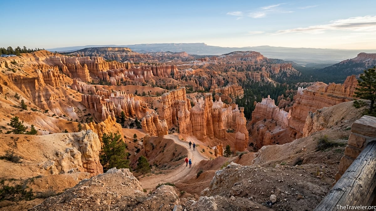
Understanding Bryce Canyon’s Layout and Seasons
Bryce Canyon sits on the Paunsaugunt Plateau in southwestern Utah at roughly 8,000 to 9,000 feet of elevation. Instead of one giant canyon, it is a series of natural amphitheaters carved into the plateau edge. Almost everything a first time visitor wants to see is strung along an 18 mile dead end park road that starts at the main entrance near Bryce Canyon City and ends at Rainbow Point. This simple layout means you can combine scenic driving and short hikes in a logical progression, without worrying about complex navigation.
Because of its elevation, Bryce Canyon is noticeably cooler than nearby desert parks like Zion. Summer daytime highs at the rim are often in the 70s or low 80s Fahrenheit, while nights can be in the 40s or 50s. In winter, from roughly December through February, snow and ice are common and some trails down into the amphitheater can close temporarily, especially steep sections like Wall Street on the Navajo Loop. Shoulder seasons in May, June, September and early October are particularly attractive, with relatively mild temperatures and generally good trail conditions, though afternoon thunderstorms are possible in midsummer.
Weather can change quickly at this altitude. It is common for visitors who left St. George or Zion in T shirts to arrive at Bryce and find temperatures 20 to 30 degrees cooler, with strong wind at the rim. Smart planning means packing layers, a beanie and gloves even in late spring, and checking the park’s current alerts on the National Park Service site before committing to long hikes. Snow or heavy rain can affect trail openings, especially on the popular figure eight style loops connecting Navajo, Queens Garden and Peekaboo.
The high elevation also affects how you experience the park on foot. Trails that look short on paper can feel much harder when you are climbing steep switchbacks at 8,000 feet. A three mile loop with about 600 to 900 feet of elevation gain, such as the Queens Garden and Navajo combination, can take two to three hours for visitors who are not acclimated, especially if they stop for frequent photos.
Entrance Fees, Shuttles and Practical Logistics
Bryce Canyon charges a standard entrance fee that, as of 2026, is typically in the mid thirties for a private vehicle and around twenty dollars per person for those entering on foot or by bicycle, valid for seven days. On top of that, the National Park Service now requires most non US residents aged 16 and over to pay an additional nonresident fee per person unless they hold an eligible annual or America the Beautiful pass. Fees can change, so it is wise to verify current amounts on the park’s official fee page before your trip. All entrance stations have moved toward cashless payment, so you should plan to pay by card.
Many visitors combine Bryce with a road trip to Zion, Capitol Reef or Grand Staircase Escalante. From Zion’s Springdale area, the drive to Bryce Canyon typically takes about two hours and thirty minutes in regular traffic via US 89 and Utah 12. This makes Bryce a popular one night stop. While you can see the main amphitheater viewpoints in half a day, staying at least one night in Bryce Canyon City or in the park’s lodge area lets you see sunrise and sunset from the rim, which are among the most memorable parts of a visit.
In the busy season, generally from April through October, Bryce operates a free shuttle that serves Bryce Canyon City, the visitor center and the main amphitheater viewpoints including Sunrise, Sunset, Inspiration and Bryce Point. The shuttle is not mandatory, but using it means you can leave your car at your hotel or at the shuttle station and avoid circling for parking at peak times. For example, a common pattern is to park at the shuttle station in Bryce Canyon City in late morning, ride to Sunrise Point for a hike, then get picked up at Bryce Point later in the day after a one way trek.
Facilities are concentrated near the entrance and the Bryce Amphitheater. The visitor center sits a short drive from the entrance station and is the best place to check current trail conditions, ask about closures such as mudslide damage on the Navajo Loop, fill water bottles and buy a paper map. Inside the park you will find restrooms at major viewpoints and picnic areas scattered along the road, but there are no services beyond the main developed area. Fuel is available in Bryce Canyon City just outside the park, so it is prudent to fill your tank before you commit to the full scenic drive to Rainbow Point and back.
Classic Bryce Canyon Viewpoints and How to See Them
The signature experience at Bryce Canyon is standing on the rim of the Bryce Amphitheater and looking down over thousands of hoodoos glowing in shades of orange, cream and red. Four viewpoints bracket this main amphitheater: Sunrise Point, Sunset Point, Inspiration Point and Bryce Point. Many visitors see all four in a single loop, either by car or shuttle. Each offers a slightly different angle and is worth a brief stop, especially if you are a photographer.
Sunrise Point and Sunset Point are closest to the main services area and are connected by a flat, paved half mile stretch of the Rim Trail. Sunrise Point faces northeast and is named for the way first light catches the hoodoos and the distant Aquarius Plateau; this is an excellent place to start your first morning, arriving around 20 to 30 minutes before local sunrise. Sunset Point, by contrast, is oriented more toward the west and southwest, and tends to shine in late afternoon when side light emphasizes the textures of formations like Thor’s Hammer below. A practical example is spending sunrise at Sunrise Point, walking slowly along the rim to Sunset Point, then dropping into the canyon on the Navajo or Queens Garden trail for a mid morning hike.
Inspiration Point offers tiered viewpoints that climb higher above the amphitheater. A short but steep stroll leads from the parking lot up to lower, middle and upper overlooks, each with expanding views to the north and south. On a clear day, you can see the colorful cliffs of the Grand Staircase in the distance. Because the path here is steeper and more exposed than the paved rim near Sunrise and Sunset Points, it can be slick in winter or after rain, and families often hold children’s hands close to the edge.
Bryce Point sits to the south of the main amphitheater and provides a sweeping balcony view that many frequent visitors consider the single best overlook in the park. It shines around sunrise, when the entire amphitheater below seems to catch fire in soft light. In high season mornings, it is common to see a line of tripods set up along the railing here, with visitors capturing long exposure panoramas. Even if you are not a photographer, watching the shifting shadows move through the hoodoos from Bryce Point for 15 to 20 minutes is one of the most atmospheric ways to begin a full day of hiking.
Best Hiking Routes for First Time Visitors
Bryce’s trail network has an unusual advantage: many of the classic hikes connect to each other, allowing you to tailor loops based on your time and energy. Most first time visitors start with one of three routes that descend from the rim into the heart of the hoodoos near the main amphitheater: the Queens Garden and Navajo Loop combination, the shorter Navajo Loop on its own, and the longer Peekaboo Loop.
The Queens Garden and Navajo combination is often recommended as the ideal introductory hike. Typically done as a three mile to three and a half mile loop in two to three hours, it starts at Sunrise Point, winds gently down past formations that resemble miniature castles and spires, and then climbs more steeply back to the rim near Sunset Point via the Navajo section. Along the way you pass named features like Queen Victoria and Thor’s Hammer, and walk through windows cut into the rock. For many families staying in Bryce Canyon City, this is the single hike they prioritize; an example itinerary would be to start around 8:00 in the morning in summer, finish the loop before midday heat, then return to town for lunch.
The Navajo Loop itself is shorter, around one and a half miles, but its switchback climbs can feel punishing at altitude. Traditionally, the loop includes two branches, one through a narrow, dramatic slot like corridor called Wall Street and another past the Two Bridges formation. After heavy rain or winter freeze and thaw cycles, the Wall Street side is sometimes closed due to rockfall or mudslides, leaving only an out and back or partial loop via Queens Garden. It is important to ask rangers at the visitor center or check the park’s latest conditions page if your heart is set on specific features like Wall Street.
For those with half a day and good fitness, the Peekaboo Loop adds a more remote feel while still staying close to the main amphitheater. The loop is roughly five and a half miles with substantial ups and downs. Many experienced hikers combine Queens Garden, Navajo and Peekaboo into what the park guide calls the Figure Eight Loop, a six plus mile outing that can take four to five hours with photo stops. A real world example is a visiting couple who take the first shuttle to Bryce Point, hike down to join the Peekaboo Loop, then continue on to connect with Queens Garden and emerge at Sunrise Point in time for a late lunch at the lodge.
If you prefer longer, less crowded hikes with big landscape views, the eight mile Fairyland Loop on the northern end of the park is a strong alternative. Starting from Fairyland Point or even from the rim near Sunrise Point, this trail spends more time on exposed ridges and open slopes, with broad perspectives on Boat Mesa and distant mesas. Because Fairyland sits higher and more exposed, it can be windy and feels more committing than the amphitheater loops; many hikers carry at least two liters of water and start by 7:00 or 8:00 in the morning in summer.
Scenic Drives and Short Walks for Non Hikers
Even if you never leave the pavement, Bryce Canyon’s main park road offers a classic scenic drive. The most efficient strategy is often to drive all the way to the end at Rainbow Point and Yovimpa Point first, then work your way back toward the entrance, stopping at overlooks on the return. This way, you are always pulling into overlooks on the right side of the road, and you can adjust your timing for light and crowds as you go. The full round trip from the entrance to Rainbow Point with stops typically takes three to four hours for visitors who want to get out and take photos at most viewpoints.
Rainbow Point and Yovimpa Point, reached by a short walk from the parking area, offer expansive views over the forested plateau and the multi colored cliffs of the Grand Staircase to the south. On a clear day you can see for dozens of miles, and interpretive signs point out distant landmarks. From here, you can add a short stroll along the Bristlecone Loop, a one mile path that passes ancient bristlecone pine trees and several fenced overlooks. Because this end of the park sits at over 9,000 feet, you may find temperatures here far cooler than at the entrance, and snow often lingers into late spring.
On the drive back toward the main amphitheater, smaller overlooks such as Natural Bridge, Agua Canyon and Ponderosa Canyon offer quick photo stops with short walks from your car. Natural Bridge in particular is a favorite, framing a red rock arch against a green forest backdrop. Families with small children or older travelers often build a loop of these overlooks, spending ten to fifteen minutes at each, without committing to longer hikes.
Within the Bryce Amphitheater area itself, the paved Rim Trail segment between Sunrise Point and Sunset Point is a highly accessible option. The trail is generally flat, fenced in many sections and suitable for strollers and visitors using mobility aids during dry conditions. It is common to see multi generational families strolling this half mile stretch around midmorning, stopping often to look down into the hoodoos at different angles. Those with a bit more energy can continue along the rim to Inspiration Point or even as far as Bryce Point, turning around whenever they have had enough.
Timing Your Visit, Crowds and Safety Tips
Bryce Canyon’s crowds follow predictable patterns. Summer brings the highest overall visitation, with tour buses often arriving by midmorning and parking lots at Sunrise and Sunset Points filling by late morning. If your schedule is flexible, arriving at the park entrance before 8:00 in the morning or after 3:00 in the afternoon can dramatically improve your experience, especially if you plan to drive your own car rather than rely on the shuttle. Many travelers driving in from Zion on a one day schedule underestimate how much time they will spend in transit and at the entrance station queues in peak hours.
Early and late light are also the most rewarding for photography and general atmosphere. A practical pattern for a one full day visit in peak season might be: sunrise at Sunrise Point, a morning hike such as Queens Garden and Navajo, lunch and a rest during the midday crowds, then an afternoon scenic drive to Rainbow Point with shorter walks at Natural Bridge and Agua Canyon, finishing with sunset at Sunset Point. In shoulder seasons, when daylight hours are shorter and temperatures lower, you might condense this by focusing more on the amphitheater and skipping the full southern drive.
Safety wise, the biggest issues in Bryce are altitude, dehydration, sun exposure and footing. Even on cool days, the high desert sun can be intense. Wearing a wide brimmed hat, sunglasses and lightweight long sleeves, and carrying enough water for every person in your group, is more important here than at many lower elevation parks. Trail surfaces can be sandy and loose; closed toe shoes with good tread, such as basic hiking shoes or trail runners, are strongly recommended. In winter and early spring, many visitors rent or buy simple traction devices to slip over their boots for icy sections on the rim and upper switchbacks.
Thunderstorms are a regular feature of July and August afternoons. While Bryce’s trails do not involve technical scrambling, being on high exposed rims in lightning is not recommended. If the forecast calls for storms, aim to complete longer hikes before early afternoon and be willing to retreat to the visitor center, your vehicle or Bryce Canyon City if thunder begins. The park provides weather updates and posts signs at trailheads when conditions are marginal, but individual judgment still matters.
Building a Sample Itinerary Around Hikes and Viewpoints
For travelers with just one full day inside Bryce Canyon, a realistic, hiking focused itinerary might look like this. Arrive the evening before and stay in Bryce Canyon City or at the park lodge. Wake before dawn, drive or take the shuttle to Sunrise Point and watch the amphitheater change color at sunrise. Around 7:30 or 8:00, start the Queens Garden and Navajo loop, giving yourself two to three hours to walk down among the hoodoos and climb back up at a comfortable pace. Stop often for photos of Queen Victoria, Thor’s Hammer and the soaring rock walls along the route.
After the hike, spend late morning exploring the visitor center, eating an early lunch and perhaps walking the paved rim between Sunrise and Sunset Points. In mid afternoon, when crowds peak in the amphitheater, shift to the southern scenic drive. Drive all the way to Rainbow Point, take in the views from Rainbow and Yovimpa Points, then walk the short Bristlecone Loop if conditions allow. On your way back to the entrance, stop at Natural Bridge and one or two other overlooks, taking advantage of the lower late afternoon sun. Finish the day by returning to Sunset Point for the golden hour and sunset, when shadows stretch across the hoodoos.
If you have a second full day, you can deepen your hiking experience. One option is to tackle the Figure Eight combination of Queens Garden, Navajo and Peekaboo, starting early to beat the heat, and then add a slower paced afternoon along the rim or a short drive to Mossy Cave, a separate, lower elevation district outside the main entrance. Another is to devote the morning to the eight mile Fairyland Loop, starting at dawn from Fairyland Point or Sunrise Point, then spending the afternoon revisiting your favorite viewpoints or simply relaxing at your accommodation.
Travelers who prefer more relaxed walking can build a two day trip around rim viewpoints and easy paths. Day one might be entirely focused on the Bryce Amphitheater, using the shuttle to hop between Sunrise, Sunset, Inspiration and Bryce Points, with multiple strolls along the rim and only a very short descent on the upper sections of Queens Garden. Day two could prioritize the southern scenic drive with frequent stops and a picnic at one of the roadside tables, plus an evening stargazing session, as Bryce is one of the darker night skies in the region when clouds cooperate.
The Takeaway
Bryce Canyon National Park is one of the rare places where world class scenery is accessible in just a day or two, without the need for advanced backcountry skills. Its compact layout, shuttle system and concentration of viewpoints make it forgiving for first time visitors, while its network of interlinked trails offers genuine adventure for those looking to lace up their boots. Whether you spend your time strolling the rim between Sunrise and Sunset Points, hiking the Queens Garden and Navajo combination beneath towering hoodoos, or driving the full length of the park road to stand at Rainbow Point, the key is to pace yourself at altitude, remain flexible around weather and trail conditions, and allow enough time for the light to work its magic on the stone.
By understanding the park’s seasons, logistics and trail options before you arrive, you can design a visit that matches your fitness and interests, instead of rushing from overlook to overlook. With realistic expectations and a bit of planning, Bryce Canyon becomes not just a quick stop on a Utah road trip, but a highlight in its own right, offering some of the most memorable hiking, scenic driving and epic viewpoints in the American Southwest.
FAQ
Q1. How many days do I need to see Bryce Canyon’s main highlights? Most travelers can see the primary viewpoints and do one classic hike, such as the Queens Garden and Navajo loop, in a single full day, but staying two nights gives you time for sunrise, sunset and at least one longer hike without feeling rushed.
Q2. Do I need a car, or can I rely only on the park shuttle? You can experience the main amphitheater and several hikes using only the free shuttle during its operating season, but having a car makes it easier to reach the southern viewpoints like Rainbow Point early or late in the day, and is useful outside shuttle months.
Q3. What is the best time of year to visit for hiking? Late May through June and September through early October usually offer the best combination of open trails and moderate temperatures, though you should still expect cool mornings, possible afternoon thunderstorms in midsummer and occasional early or late season snow at the rim.
Q4. Are there easy hikes suitable for young children or older visitors? Yes, the paved rim section between Sunrise and Sunset Points is very gentle and has frequent railings, and short partial descents on Queens Garden allow families to sample the hoodoos from below without committing to the full loop or steep switchbacks.
Q5. How early should I start hikes like Queens Garden and Navajo Loop? In the busy season it is wise to start between 7:00 and 8:00 in the morning to find parking more easily, avoid midday heat and give yourself plenty of time to climb the upper switchbacks at a relaxed pace.
Q6. Can I visit Bryce Canyon as a day trip from Zion National Park? Many visitors do this, driving about two and a half hours each way between Springdale and Bryce, but it makes for a long day; if possible, spending at least one night near Bryce provides a more relaxed experience and lets you see sunrise or sunset from the rim.
Q7. What should I wear and bring for summer hikes? Lightweight layers, sun protection including a wide brimmed hat and sunglasses, sturdy closed toe shoes with good traction and at least one to two liters of water per person for moderate hikes are recommended, with more water for longer routes like Peekaboo or Fairyland.
Q8. Is Bryce Canyon safe to visit in winter? Yes, many people visit in winter for snow covered hoodoos and quieter trails, but you should be prepared for icy paths, potential trail closures, very cold temperatures and shorter daylight hours, and traction devices for your shoes can be very helpful on the rim and upper switchbacks.
Q9. Do I need a permit to hike the main trails? No special hiking permits are required for day use on the popular trails such as Navajo, Queens Garden, Peekaboo or Fairyland; your regular park entrance fee covers access, though overnight backcountry trips in remote parts of the park involve additional regulations.
Q10. Are there food and lodging options inside or near the park? Inside the park you will find a lodge complex and seasonal dining options near the main amphitheater, while just outside the entrance in Bryce Canyon City there are several chain style hotels, independent motels, campgrounds and restaurants that cater to park visitors.