
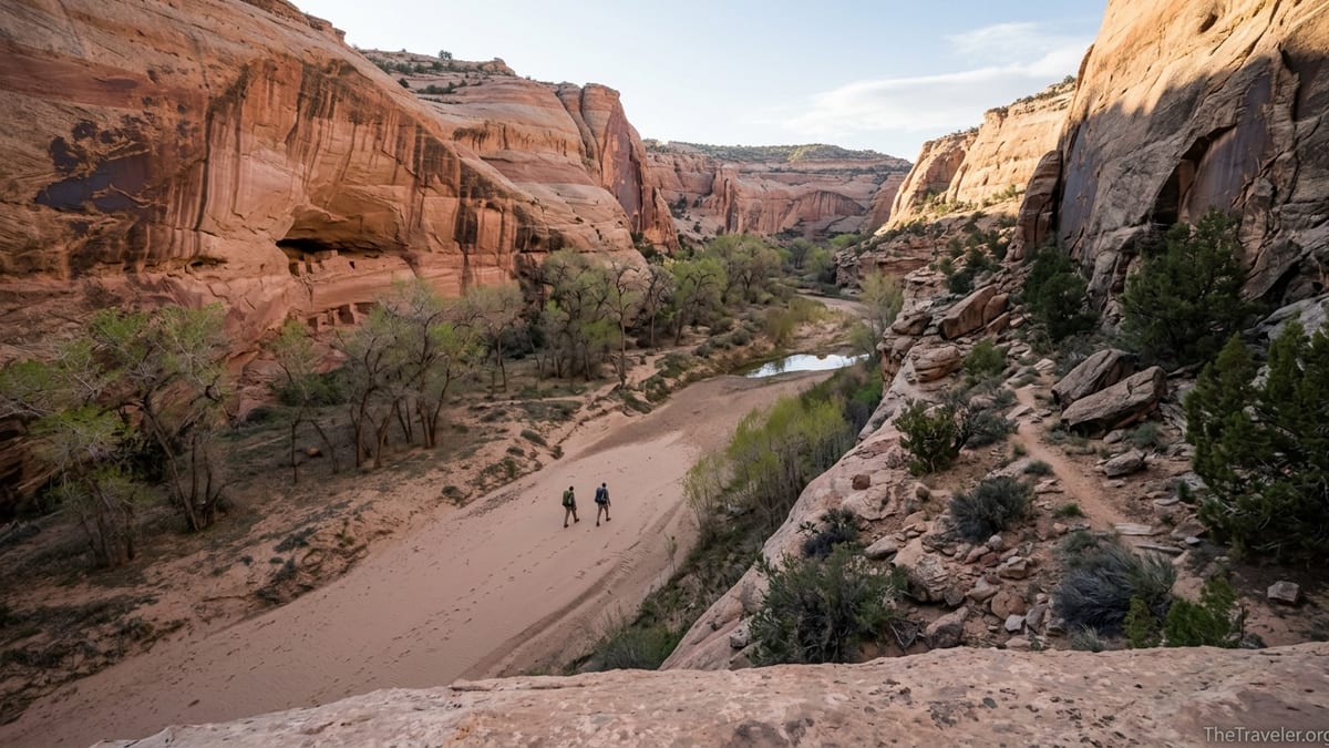
Deep in the sandstone plateaus of southeastern Utah, Grand Gulch winds more than 50 miles through Bears Ears National Monument, carving a labyrinth of side canyons lined with ancient dwellings and rock art. For experienced hikers, it offers one of the most rewarding backpacking experiences in the desert Southwest, combining remote red rock scenery with a rare chance to see millennia of human history in place. Visiting Grand Gulch, however, requires careful planning, the right permits and a strong commitment to traveling with respect.
Get the latest updates straight to your inbox!
Understanding Grand Gulch and Why It Matters
Grand Gulch lies on Cedar Mesa in Bears Ears National Monument, managed primarily by the Bureau of Land Management’s Monticello Field Office. It is designated as a Wilderness Study Area and a special recreation management area, which means you will not find constructed trails, directional signs or developed campgrounds once you leave the trailhead. The main canyon runs roughly from just south of Natural Bridges National Monument down to its confluence with the San Juan River, with access through tributaries like Kane Gulch, Bullet Canyon and Collins Canyon.
This landscape is globally significant for its concentration of Ancestral Puebloan sites. Cliff dwellings, granaries, kivas, pottery sherds and rock art panels appear throughout the system, often tucked under overhangs or on ledges above the canyon floor. Unlike in many national parks, these places are mostly un-fenced and un-interpreted, with few signs or railings. That sense of discovery is part of Grand Gulch’s appeal, but it also means visitors carry a serious responsibility to avoid damage to fragile sites and leave artifacts exactly where they have rested for centuries.
Conditions are also demanding. There are no reliable constructed water sources, the canyon bottom can turn to mud after storms, and routes in and out can be steep, sandy and occasionally exposed. Temperatures swing from freezing nights in March to triple-digit heat in July. In practice, a trip into Grand Gulch is less like a marked national park trail and more like an extended cross-country route where you follow a footpath, map and your own judgment through a living archaeological landscape.
Because of these sensitivities, the area is actively managed with permit quotas and group-size limits. Ranger staff at Kane Gulch Ranger Station monitor water sources, check visitor compliance, and provide up to date information on conditions. Planning your trip around these systems is not optional; it is how you help ensure Grand Gulch remains open and intact for future backpackers and for Tribal communities with deep connections to the canyons.
Permits, Fees and Regulations
Backpacking in the canyons of Cedar Mesa, including Grand Gulch and tributaries such as Kane Gulch, Bullet Canyon, Collins Canyon and Government Trail, requires an overnight permit year round. These noncommercial backpacking permits are issued through Recreation.gov for Bears Ears / Cedar Mesa backpacking and cover specific entry points and dates. In peak seasons like late March through May and late September through October, many dates book out weeks in advance, so it is wise to secure permits as soon as your plans solidify rather than waiting until the last minute.
Fees are modest compared with many national parks but are still an important detail in your budget. Expect a per-person nightly fee for overnight permits, plus a small reservation charge on the booking platform. Day hiking in Grand Gulch and several nearby canyons also requires a paid day-use pass, which you can typically obtain at self-serve kiosks at trailheads or at Kane Gulch Ranger Station. While costs vary slightly by year and management updates, a realistic planning figure for a three night, two person backpacking trip might be on the order of tens of dollars in permit and pass fees, not hundreds.
Regulations are designed around both safety and cultural resource protection. Group sizes are capped for overnight trips, often at around eight people for noncommercial parties, with commercial or organized groups (such as schools or clubs) requiring a separate Special Recreation Permit from the BLM’s Monticello Field Office. Camping is prohibited within certain buffer distances of popular ruins, along segments of the canyon with heavy visitation, and near trail junctions. Fire restrictions vary seasonally but are commonly tight; many parties choose to leave stoves and eat cold to reduce impacts.
Before you shoulder a pack, plan to stop at the Kane Gulch Ranger Station on Utah Highway 261 if it is open for the season. Spring and fall hours are often limited to mornings on specific days of the week, and you can confirm current hours through BLM and local visitor information resources before you drive out. At the station, rangers may check your permit, review no-trace guidelines, show a short educational video on visiting archaeological sites respectfully and answer questions about water levels at key springs, route conditions and weather.
Choosing Routes and Trip Length
Most first time visitors experience Grand Gulch on a two to four day backpacking trip that enters through one tributary, heads down canyon, then exits via another. A classic example is the Kane Gulch to Bullet Canyon route, which allows you to see well known sites like Turkey Pen Ruin and Junction Ruin in the main gulch, then climb out past Perfect Kiva and Jailhouse Ruin in Bullet Canyon. This trip might cover 20 to 25 miles depending on side explorations and usually fits well into a three day, two night itinerary for strong hikers.
Another popular loop uses Government Trail to access the main canyon and then exits via Kane Gulch or Collins Canyon. Government Trail begins on the mesa and drops south into Grand Gulch, intersecting the main drainage near features like Polly’s Island. From there, backpackers can choose to explore up canyon toward Junction Ruin or down canyon toward more remote sections that see fewer day hikers. A four or five day journey from Government Trail to Collins Canyon and out allows ample time to linger at side canyons, springs and ruins along the way.
For those seeking solitude and willing to carry enough water, longer traverses are possible. Experienced desert travelers sometimes spend up to a week moving between Shieks Canyon, Green Mask area, Grand Gulch proper and downstream sections closer to the San Juan River. These extended itineraries demand careful attention to seasonal water availability and emergency exit routes, and are best attempted after at least one shorter trip in the system or with a partner who knows the area well.
Shorter options include day hikes from Kane Gulch trailhead down to Junction Ruin and back, or out and back hikes from Bullet Canyon trailhead to Perfect Kiva. These make good introductory trips if you are not ready for a full backpack or if your travel window is tight. Even on a single long day, you can experience canyon narrows, hanging gardens and several major sites, while still getting a sense of the canyon’s remoteness once you leave the rim.
Season, Weather and Water
The most favorable seasons for backpacking Grand Gulch are spring and fall. From roughly late March through early May, daytime highs often range from the 60s to low 80s Fahrenheit on the canyon floor, with nights that can dip below freezing at higher elevations on the rim. Spring can bring gusty winds and occasional late snow squalls on the mesa, but wildflowers and flowing seeps make the canyon itself especially appealing. In fall, late September through October typically brings crisp mornings, warm afternoons and clearer skies, with water sources gradually shrinking as the dry season progresses.
Summer brings harsh sun and potentially dangerous heat. Midday temperatures in June and July can exceed 95 degrees Fahrenheit in the canyon, with little shade except under overhangs and cottonwood stands. Water becomes scarcer, and afternoon monsoon thunderstorms can create flash flood risk in narrow sections. A summer overnight trip requires an advanced heat management strategy, including hiking in early morning and late evening, resting through the hottest hours, and carrying significantly more water between seeps and pools than you might in April.
Water is the defining logistical challenge in Grand Gulch. Springs and potholes exist throughout the system, but their reliability varies seasonally and year to year. For example, in a wet spring, hikers often find flowing water in lower Kane Gulch, at junctions such as Green Mask area, and near Bullet Canyon’s hanging springs. In a dry fall, some of these sources may shrink to a few cloudy pools or disappear entirely. Rangers at Kane Gulch post current condition reports during their operating seasons, and recent trip reports from reputable guide services or conservation organizations can provide additional context, but you should always be prepared to walk past a source that looked good on paper and find the next one instead.
A practical planning rule is to carry at least four liters per person when leaving a known good source, more if you are unsure what lies ahead. Many parties use one or two lightweight gravity filters paired with chemical backup treatment for silty water. Given the amount of cow sign in some upper sections and the presence of wildlife throughout the area, every drop should be treated. On multi day routes, it is common to camp within a short walk of water rather than on the most scenic bench you passed earlier in the day, trading a dramatic view for a safe refill before the next leg.
Access, Trailheads and Logistics
Most trips into Grand Gulch start on Utah Highway 261, the paved road that runs over Cedar Mesa between U.S. Highway 95 and Highway 163. The Kane Gulch Ranger Station and trailhead sit a short drive off 261 on a well maintained spur road suitable for most passenger vehicles in dry conditions. Bullet Canyon and Government Trail trailheads lie farther south on graded dirt roads that can become slick and rutted after storms. Collins Canyon and some lesser used access points involve longer drives on unpaved roads, where recent reports about washouts or soft sand are especially valuable.
For example, a visitor flying into Salt Lake City might rent a standard SUV, drive roughly six hours to the town of Blanding or Bluff for a night in a motel, then head up to Cedar Mesa early the next morning. After checking in at Kane Gulch Ranger Station, they could leave one car at the exit trailhead, such as Bullet Canyon, and then shuttle to their entry point at Kane Gulch. Solo travelers often rely on informal shuttles arranged through local outfitters in Bluff, Mexican Hat or Monticello, which can cost the equivalent of a tank of gas or more but save many miles of backtracking on the mesa.
Parking at trailheads is usually simple but comes with desert norms. There are no full time attendants or paved lots; you will park on hardened dirt or rock, avoid cryptobiotic soil and tuck vehicles close to other cars to leave room. Some trailheads, like Bullet Canyon, have vault toilets but no potable water, so you should fill all containers in town or at established gas stations before driving onto Cedar Mesa. Cell coverage is limited to nonexistent across most of the area, so do not assume you can confirm shuttles or weather once you leave town.
Because Grand Gulch sits at a relatively high elevation compared with lower desert parks, early season trips may encounter lingering snow or ice on the mesa roads and at the canyon rim. In late March, you may find bare ground and comfortable temperatures in the canyon while still crunching across a few remaining snow patches at the trailhead. Checking road conditions with BLM or local sheriff’s dispatch before you drive in can help you avoid getting stuck in spring mud season, a common issue when warm days thaw the surface of clay roads that were frozen solid overnight.
Gear, Skills and Desert Safety
Backpacking in Grand Gulch does not require technical climbing gear, but it does demand solid navigation, fitness and desert specific equipment. A typical kit includes a 40 to 50 liter backpack, a three season tent or mid that can handle wind and sandy ground, a 20 to 30 degree Fahrenheit sleeping bag or quilt for spring and fall, and a compact sleeping pad that insulates well from cold sand or rock. Footwear is usually lightweight hiking boots or trail runners with good traction on sandstone and the ability to shed sand quickly; gaiters can be helpful in sandy washes.
Navigation should be built around redundancy. Paper maps such as BLM’s Grand Gulch map or a reputable Cedar Mesa overview map, combined with a compass and at least one GPS-enabled device with downloaded offline imagery, give you options when one system fails. While there is generally a clear social trail along the canyon bottom and in major side drainages, braided paths and game trails can lead you astray near junctions or in wide sandy sections. Small mistakes can mean backtracking through deep sand or climbing back out of the wrong side canyon with a heavy pack and limited water.
Sun exposure is intense even in cooler months, so wide brim hats, sunglasses with strong UV protection, lightweight long sleeve shirts and high-SPF sunscreen are standard gear. Many experienced desert hikers carry a reflective umbrella for mid day stretches and schedule hiking for early morning and late afternoon. A minimalist but effective first aid kit, emergency communication device such as a satellite messenger, and basic repair items for gear round out a typical Grand Gulch packing list.
Desert hazards extend beyond heat and dehydration. Flash floods, while less common in wide parts of Grand Gulch than in slot canyons, are still a risk during powerful storms. If forecast information suggests a strong monsoon system, be prepared to adjust plans or stay on higher benches away from constricted narrows. Snakes, including rattlesnakes, can be active in warmer months, particularly around rock piles and shady ledges. Bites are rare when hikers watch their footing, avoid putting hands into unseen cracks and give animals space to move away.
Visiting Ancient Ruins with Respect
The greatest privilege of traveling through Grand Gulch is the chance to be in the presence of ancient dwellings and rock art in their original setting. It is also the area’s greatest vulnerability. Many sites are unmarked, which means you might first see them as a line of masonry peeking from a ledge or a faint panel of figures emerging on a sunlit wall. In every case, the guiding principle is simple: admire from a distance and do not touch. That means never entering structures, sitting on walls, leaning on plastered surfaces, or trying to clear sand or debris from rooms or kivas.
Artifacts belong exactly where they are. Pottery sherds, stone tools, corncobs and other cultural materials may be scattered around dwellings, sometimes in surprising abundance. Federal law prohibits collecting, moving or stacking these items, and rangers regularly document damage from visitors who have gathered sherds into piles or taken them as souvenirs. If you find yourself stepping near artifacts, you are probably too close; step back until you can view the site without risk of disturbing the ground. Photographs are welcome as long as they do not involve touching or rearranging anything for a better shot.
Rock art requires particular care. Oils from human skin can accelerate the deterioration of painted or pecked images, so it is critical never to touch the panels. Chalk, water or digital enhancement for photography are all inappropriate in this setting. If you need a better view, use a zoom lens rather than moving closer on an unstable slope. Where social trails have grown directly under panels, consider whether your presence may knock small rocks loose onto the wall or kick dust that will cling to fragile surfaces.
Noise and light also affect the character of these places. Many visitors choose Grand Gulch precisely because it feels quieter and more contemplative than high-use parks. Using low voices near sites, avoiding music on speakers and limiting artificial light at night around camp all help preserve that atmosphere. Some ruins are important to modern Tribal communities for ceremony and memory. Treat them as you would an active place of worship, whether or not anyone else is present.
The Takeaway
A backpacking trip into Grand Gulch is not just another desert hike. It is a journey through a canyon that functions as both wilderness and open-air archive, where the record of human life spans centuries along the same dusty trails you follow today. Reaching it involves long drives on remote roads, limited services, and the uncertainty of natural water sources, but those logistical hurdles are part of what keeps the canyon from feeling overrun.
With a realistic permit plan, careful route choice, solid desert skills and a deep commitment to visiting ancient places with respect, you can experience days of walking between towering walls, cottonwood groves and quiet ruins that emerge from the rock just when the light is right. Many hikers come away from Grand Gulch with fewer photos than from other trips but stronger memories, shaped by the sense that they moved gently through a landscape that still holds more stories than any visitor can see in a lifetime.
If you approach Grand Gulch as a guest rather than a consumer of scenery, you help ensure that its canyons remain a living place for the Indigenous communities who know it best and a challenging, rewarding destination for future backpackers. In an era of increasingly crowded trails, that combination of adventure and reverence is what makes Grand Gulch one of the most compelling desert journeys in the American Southwest.
FAQ
Q1. Do I need a permit to backpack in Grand Gulch? Yes. Overnight backpacking in Grand Gulch and its Cedar Mesa tributaries requires a permit, typically reserved in advance through official federal recreation systems.
Q2. What is the best time of year to visit Grand Gulch? Most backpackers aim for late March through May and late September through October, when temperatures are moderate and water sources are more reliable than in midsummer.
Q3. How difficult are the main Grand Gulch routes? Routes are nontechnical but strenuous, with steep entry and exit trails, sandy washes, off-trail navigation and heavy packs due to water carrying needs. Prior backpacking experience is strongly recommended.
Q4. Are there reliable water sources in the canyon? Water exists at springs and pools but varies widely by season and year. Always check recent reports, plan conservative carries between known sources and treat all water before drinking.
Q5. Can beginners backpack in Grand Gulch? Fit beginners with experienced partners sometimes succeed, but the combination of navigation challenges, limited water and lack of cell service makes the area better suited to those with at least a few multi day trips already completed.
Q6. Is it possible to visit ruins on a day hike instead of backpacking? Yes. Popular day hikes from trailheads like Kane Gulch or Bullet Canyon reach significant ruins and rock art, allowing you to experience the canyon without carrying an overnight pack.
Q7. Are campfires allowed in Grand Gulch? Fire regulations change with conditions, and wood is scarce. Many visitors forego fires entirely, relying on camp stoves or cold meals to minimize impacts and comply with current rules.
Q8. What kind of vehicle do I need to reach the trailheads? In dry conditions, most trailheads are accessible in a standard passenger vehicle, though a higher clearance SUV can be helpful on rougher dirt roads, especially after storms.
Q9. How can I avoid damaging archaeological sites? Stay on durable surfaces, keep back from walls and structures, never enter rooms, and leave all artifacts exactly where you find them. If you see impacts, report them to rangers.
Q10. Do I need to worry about bears or other large animals? Bears are uncommon on Cedar Mesa itself. More typical wildlife encounters include deer, small mammals, birds and occasionally rattlesnakes, which generally avoid people if given space.