
Like many visitors to Great Smoky Mountains National Park, I thought of Laurel Falls as an easy, scenic “quick stop” before a longer day of exploring. A short paved trail, a classic 80-foot waterfall, and a convenient trailhead just a few miles from Gatlinburg sounded like the perfect warm-up. Instead, I found myself circling for parking, weaving through crowds, and learning firsthand how one of the park’s most popular waterfalls has become a case study in what it means to hike in America’s busiest national park.
Get the latest updates straight to your inbox!
Arriving Expecting a Quick Stroll
If you glance at a Smokies brochure, Laurel Falls looks like the definition of low-commitment. The trail is only about 2.6 miles round trip with roughly 300 feet of elevation gain, paved most of the way, and starts about 3 miles west of Sugarlands Visitor Center. That combination of short distance, gentle grade, and a picture-perfect waterfall has made it one of the most popular hikes in the park.
On the morning I visited, I left Gatlinburg just after 9 a.m. thinking I was ahead of the curve. It was a mild April weekday, not a peak fall foliage weekend or mid-July holiday. I grabbed a coffee in town, figured I would spend an hour or so on the trail, then move on to Newfound Gap Road by lunch. The map made it look simple: drive out Fighting Creek Gap Road, park at the clearly marked Laurel Falls lot, stretch my legs, and be back to the car in no time.
What I did not factor in was the cumulative pull of millions of visitors funneled toward a handful of “must see” stops in the Smokies. Great Smoky Mountains National Park has hosted over 12 million visitors annually in recent years, with more than 13 million in some years. Many of them, just like me, are looking for a short waterfall hike close to Gatlinburg. At Laurel Falls, that expectation is shared by so many that the idea of a quick stop can dissolve the moment you round the final curve toward the trailhead.
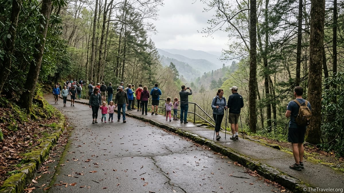
When I reached the Laurel Falls area, traffic slowed to a crawl. Cars idled along the narrow two-lane road, drivers peering hopefully at every gap. A queue of hikers in athleisure and camera straps clustered around the trail sign, while others threaded between bumpers with trekking poles and strollers. I quickly realized this would not be a park-at-the-trailhead-and-go kind of morning.
Parking, Tags, and the Reality of a Busy Trailhead
The first surprise was how little designated parking there actually is. Regular visitors will tell you that Laurel Falls has only a few dozen marked spaces, and park managers have spent the last few years cracking down on the unsafe roadside parking that used to stretch along the shoulder. Concrete barriers and signs now block many of those ad hoc pullouts, a safety measure that makes sense but also concentrates the pressure on the official lot.
I drove past the lot twice without seeing a single open space. Each time I reached the end of the barriers and realized there was nowhere legal to turn around, I joined a slow-motion parade of vehicles looping back toward the trailhead. A Tennessee couple in a pickup ahead of me eventually gave up and continued down the road toward Elkmont; later they told me at a picnic area that they had planned “just a quick stop at Laurel Falls” on their way to Cades Cove, but half an hour of circling convinced them otherwise.
Layered on top of the parking squeeze is the Park It Forward system, which since 2023 has required visitors to display a paid parking tag if they leave a vehicle for more than 15 minutes anywhere in the park. Daily tags are relatively affordable, roughly the cost of a fast-casual lunch, but they add one more logistical step. As I watched a family from Ohio rummage through their rental car for a misplaced tag, it was clear they had assumed that a quick waterfall stop did not require much planning. A ranger gently explained that even at short, popular trails like this one, the new tags are enforced.
Eventually, after about 20 minutes of slow rolling and one well-timed departure from a compact SUV, I slid into a space. By then, the illusion of a quick stop was gone. What surprised me most was realizing that my experience was not unusual at all. Local cabin companies now warn guests that lots at Laurel Falls, Grotto Falls, and Rainbow Falls often fill by mid-morning in peak seasons, and that arriving by 8 or 8:30 a.m. offers a much better chance of parking without a long wait.
Hiking in a Moving Crowd
Once on the trail, the sense of congestion shifted but did not disappear. The first few hundred yards climbed gently through the forest on pavement dotted with wet leaves. It felt more like a city greenway than a backcountry trail, but the soundtrack was pure Smokies: birds, wind in the trees, and the distant hush of water. Then the human element kicked in. Groups bunched up at every bend where the pavement narrowed, and hiking became a matter of matching the pace of those ahead or waiting for a brief opening to pass.
There were multigenerational families in flip flops and fleece, couples with daypacks and DSLR cameras, toddlers in carriers, and a surprising number of people attempting the trail with strollers despite its uneven, cracked sections. A group of college students from Atlanta played music softly from a speaker, while an older hiker in a National Park Service volunteer vest quietly asked them to switch to headphones. The trail is not especially steep, but the constant stop and go created its own kind of fatigue.
At one tight switchback, two streams of hikers negotiated who would step aside. A woman from Michigan, pausing to catch her breath, remarked that she had thought Laurel Falls would be “like a roadside pullout with a little path,” not a trail that felt at times as busy as a weekend farmer’s market. She was not alone. I overheard more than one visitor say they had envisioned a peaceful forest walk and were startled by how social the hike felt.
That said, if you looked past the shuffle of sneakers and trekking poles, the drama of the landscape still held its own. Mountain laurel and rhododendron framed the path, their glossy leaves hinting at the blooms that give the falls its name. Occasional breaks in the trees opened fleeting views across the valley toward Cove Mountain. In quieter moments between groups, you could almost imagine what this walk might feel like on a cold January weekday when the crowds vanish and the pavement is rimmed with ice.
The Waterfall Experience, Shared With Dozens of Strangers
Laurel Falls itself is undeniably beautiful. The 80-foot cascade spills in two main tiers, separated by a narrow rock ledge and the iconic stone bridge that crosses the creek. As you approach, the sound of water swells, and then the falls appear, framed by dark rock and evergreen shrubs. It is the kind of scene that sells calendars and postcards, and the appeal is obvious the moment you emerge from the trees.
What you do not see in those postcard images are the lines of people waiting their turn on that bridge. When I arrived, perhaps 40 or 50 hikers clustered around the base area and along the path leading to the crossing. A queue formed almost organically as visitors waited to take the classic photo on the bridge with the upper tier roaring behind them. Parents juggled phones and snacks, couples swapped places to get both individual and together shots, and solo travelers traded cameras with strangers to avoid full albums of selfies.
In the span of ten minutes, I heard four different languages, watched one teenager film a social media dance against the backdrop of the falls, and saw a park ranger quietly remind a group not to climb the slick rocks near the edge. The scene was vibrant and communal, but it was also a far cry from the solitary waterfall experience many hikers imagine. One visitor from Texas, balancing carefully on the wet stone lip, joked that he had not stood in a line this long since the roller coasters back home.
There were intimate moments within the bustle. A grandmother dabbed a little boy’s scraped knee while pointing out the mountain laurel blossoms. A couple celebrating their anniversary shared a thermos of coffee on a shaded boulder, tuning out the chatter around them. Still, after fifteen or twenty minutes at the falls, I felt the urge to step away simply to hear the water without the hum of conversation. On my return hike, I noticed several people turning back early, content with a partial view after deciding that pushing all the way to the bridge was not worth the crowding.
Why Laurel Falls Became a Symbol of Crowding in the Smokies
Laurel Falls is more than just a busy waterfall. It has become a focal point in the park’s ongoing effort to manage surging visitation and protect fragile resources. Since around 2011, annual visitation to the Smokies has climbed dramatically, and short, accessible trails near Gatlinburg have absorbed a disproportionate share of that pressure. Park researchers and local volunteers commonly describe Laurel Falls as one of, if not the, busiest hiking trails in the entire park.
That popularity has had consequences. In the past, visitors parked haphazardly along the roadside, eroding soil, trampling vegetation, and creating dangerous conditions on the curving mountain road. The original footpath wore badly under heavy use, leading park managers to pave the trail to stem erosion and provide surer footing. Even the historic stone bridge at the falls became a pinch point where high traffic met slick rock and steep drops on either side, prompting regular safety warnings.
In recent years, the National Park Service has tested and refined crowd-management tools at Laurel Falls. Time-limited parking, seasonal roadside barriers, and pilot shuttle experiments from Gatlinburg have all been part of an evolving strategy to keep the area accessible while improving safety. A formal Laurel Falls Trail Management Plan has been in the works, laying out options to widen portions of the trail, upgrade the bridge, and expand designated parking to replace the chaotic roadside scene that had become common on busy weekends.
Most significantly for current travelers, the park launched a major rehabilitation of the Laurel Falls Trail, closing it for an extended period starting in early 2025. The project, slated to run roughly 18 months, is designed to resurface and stabilize the path, enhance viewing platforms, and reconfigure parking. The goal is that future visitors will encounter a safer, more sustainable version of the trail, even if that means accepting new norms like parking reservations or more robust shuttle systems.
Timing, Alternatives, and How to Reclaim the “Quick Stop” Feeling
If you want Laurel Falls to feel closer to the quick, refreshing outing advertised in guidebooks, timing is everything. Rangers consistently note that park visitation peaks between about 9 a.m. and 2 p.m., and that popular trailheads near Gatlinburg often fill by mid-morning on spring, summer, and fall weekends. In practice, that means your best shot at an uncrowded experience is to arrive at the trailhead by around 7:30 or 8 a.m., or to aim for late afternoon when many day-trippers are already heading back to town.
Weather and season also play a role. Hot, humid July days and peak October foliage weekends draw the heaviest crowds. By contrast, a chilly weekday in late February or early March can transform the same trail into a much quieter experience. Water levels may be higher after a rainy spell, making the falls more dramatic, and you might share the trail with only a handful of determined hikers. Just remember that shaded pavement can be icy in winter and that sunset arrives earlier among the ridges than it does in town.
Another strategy is to pair or replace Laurel Falls with less congested alternatives. The Smokies are rich with waterfall hikes that see fewer visitors simply because they are a bit longer, steeper, or farther from Gatlinburg. Abrams Falls near Cades Cove, for example, is around 5 miles round trip and tends to attract committed hikers rather than casual strollers, though its pool area can still be busy on summer afternoons. Spruce Flats Falls, accessed from the Tremont area, offers a short but more rugged trail that many locals quietly recommend when Laurel Falls feels overrun.
Even near Gatlinburg, you can trade pavement for dirt and lose a surprising number of people in the first mile. Trails like Baskins Creek Falls or the longer routes up Mount LeConte demand more effort and time, which naturally thins the crowds. The common pattern in this park, as experienced hikers like to point out, is that if you walk more than a mile from the nearest parking lot on an unpaved trail, the density of people drops dramatically. The trick is aligning your expectations: if what you want is a quick leg-stretcher with a big payoff and you are willing to share that experience with lots of others, Laurel Falls delivers. If solitude is non-negotiable, you may be happier steering elsewhere.
Practical Tips So the Crowds Don’t Ruin Your Day
My crowded morning at Laurel Falls was not a failure, but it was a reminder that “quick stop” in a heavily visited national park is more a hope than a guarantee. With a bit of advance planning, you can tilt the odds in your favor. First, build margin into your schedule. If you think the hike will take an hour, allocate two. That extra time absorbs delays from parking, bathroom lines at Sugarlands Visitor Center, and slower crowds on the trail.
Second, treat the parking tag as a standard part of your Smokies budget, much like a daily transit pass in a city. Purchase it in advance where possible, keep it in an easy-to-reach spot in your vehicle, and remember that it applies across the park, not just at Laurel Falls. That way, you are not fumbling at the trailhead while a ranger waits or, worse, cutting your visit short to avoid a potential citation.
Third, manage your expectations about pace and atmosphere. If you know ahead of time that you will be hiking in a crowd, it is easier to lean into the social energy of the trail instead of feeling blindsided. You might overhear route tips from people who visited Clingmans Dome the day before, or chat with a local about the best place in Gatlinburg for trout and grits after your hike. For families with young kids or older relatives, the presence of many other people can also feel reassuring in case someone needs a hand or a quick rest.
Finally, always check the latest park information before you set out. Laurel Falls’ current closure for trail work, occasional road maintenance on nearby Little River and Newfound Gap Roads, and evolving congestion-management measures mean conditions can change from season to season. Visitor center staff and the park’s official updates will give you the most accurate picture of what to expect, from detours and closures to whether shuttles or reservations are in play during your stay.
The Takeaway
My visit to Laurel Falls began as a plan for a simple, low-stakes stop and turned instead into an immersion in what it means to share a beloved landscape with millions of other people. The crowds, parking hassles, and on-trail bottlenecks were real, but so were the moments of connection and the enduring beauty of the waterfall itself. Standing on the stone bridge with spray on my face and the murmur of a dozen different conversations around me, I realized that this experience is part of the modern story of the Smokies.
If you arrive expecting wilderness solitude on a short, paved trail minutes from Gatlinburg, you are almost guaranteed to be disappointed. If you arrive understanding that Laurel Falls is a communal hike in America’s busiest national park, you can adjust your timing, your tactics, and your attitude accordingly. Go early or late, plan for delays, and pair the outing with a quieter trail elsewhere in the park. Do that, and even a “quick stop” that is not actually quick can become a memorable chapter in your Great Smoky Mountains trip rather than a source of frustration.
FAQ
Q1. Is Laurel Falls currently open to visitors?
As of mid-2026, Laurel Falls Trail has been undergoing an extended rehabilitation project that began in early 2025. Portions or all of the trail may be closed at times, so travelers should verify current conditions with the park before planning a visit.
Q2. How long does the Laurel Falls hike usually take?
Most visitors take 60 to 90 minutes to complete the 2.6-mile round-trip hike, but on crowded days you should plan for up to two hours to account for parking delays and slow sections on the trail.
Q3. Do I need a parking tag for a quick stop at Laurel Falls?
Yes. Great Smoky Mountains National Park requires a valid parking tag for any vehicle parked more than 15 minutes, even for short stops at popular trailheads like Laurel Falls.
Q4. When is the least crowded time to hike Laurel Falls?
The quietest times are typically early mornings before about 8 a.m. and later afternoons after around 3 p.m. on weekdays outside of peak summer and fall foliage season, especially in cooler months.
Q5. Is Laurel Falls suitable for strollers and wheelchairs?
The trail is paved but not fully accessible. It includes uneven, cracked sections, moderate grade, and drop-offs with limited railings. Strollers are common but can be challenging, and the route is generally not recommended for standard wheelchairs.
Q6. Can I swim or wade at Laurel Falls?
Swimming and scrambling on the rocks are strongly discouraged due to slippery surfaces and the risk of falls. Rangers regularly warn visitors to stay off wet rocks near the edge of the waterfall.
Q7. Are dogs allowed on the Laurel Falls Trail?
No. Dogs are not permitted on Laurel Falls or most backcountry trails in Great Smoky Mountains National Park. Pets are limited to certain roads, campgrounds, and just two short walking paths.
Q8. What should I bring for a short hike like Laurel Falls?
Even for this relatively short hike, pack water, sturdy footwear with good grip, a light rain jacket or extra layer, and basic sun and insect protection. A small daypack keeps hands free on the crowded, uneven sections.
Q9. What are some less crowded alternatives to Laurel Falls?
For a quieter waterfall experience, consider hikes such as Spruce Flats Falls in the Tremont area, Baskins Creek Falls off the Roaring Fork Motor Nature Trail, or the longer Abrams Falls hike near Cades Cove, bearing in mind that these trails are generally rougher and more demanding.
Q10. Is a “quick stop” at Laurel Falls realistic on a busy weekend?
On peak weekends and holidays, a truly quick visit is unlikely. Parking can take 20 to 30 minutes or more, and the trail often moves slowly. If your schedule is tight, it may be better to visit at off-peak times or choose a less crowded destination.