
Ask almost any ranger or local which waterfall hike first-time visitors should try in Great Smoky Mountains National Park, and Laurel Falls will come up within seconds. This relatively short, partially paved trail near Gatlinburg combines easy access, big scenery, and a true national park atmosphere, which is exactly why it has become one of the park’s most heavily visited walks. Even as the National Park Service temporarily closes sections of the trail to rehabilitate pavement and improve safety, Laurel Falls remains the benchmark for what many travelers expect from a classic Smokies hike.
Get the latest updates straight to your inbox!
A Short, Manageable Hike With a Big Payoff
Laurel Falls works its magic by offering a lot of reward for a modest effort. The standard route to the waterfall is roughly 2.5 to 2.7 miles round trip, depending on how far you wander around the viewing area, with a steady but not extreme climb from the trailhead along Fighting Creek Gap Road. For many visitors staying in Gatlinburg, the drive from downtown to the parking area takes about 15 to 20 minutes in normal traffic, which makes it an easy half-day outing sandwiched between breakfast at a pancake house and an evening stroll through town.
The first 1.3 miles to the falls are on a paved path, which significantly lowers the barrier for casual hikers. You will see families pushing sturdy jogging strollers, grandparents using trekking poles, and visitors who have never set foot on a backcountry trail trying out their first national park hike. Although the pavement is cracked and uneven in spots, and the grade can feel surprisingly steep if you are not used to hills, most reasonably active people can reach the falls in about 45 minutes at a relaxed pace.
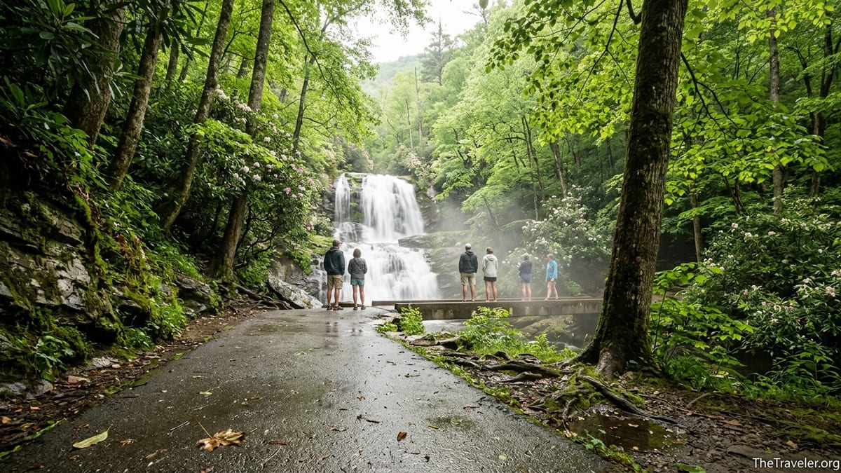
The payoff at the end explains why people put up with the climb. Laurel Falls drops roughly 80 feet in two main tiers into a rocky gorge lined with rhododendron and, in season, the flowering mountain laurel that gives the falls its name. A narrow concrete footbridge bisects the waterfall, allowing you to stand literally between the upper and lower cascades, close enough to feel a cool mist on warm afternoons. For visitors coming from flatland cities such as Orlando or Chicago, this kind of waterfall access within such a short walk feels dramatic and memorable.
Because of this big payoff-to-effort ratio, the Laurel Falls hike often becomes a family’s signature Smokies memory. It is common to meet multigenerational groups at the footbridge, with parents telling kids how they stood in the same spot 20 or 30 years earlier. That sense of tradition, layered on top of the scenery, is part of what keeps the trail near the top of recommended hikes in guidebooks, cabin welcome binders, and local visitor center conversations.
Paved Trail and Family-Friendly Appeal
Compared with most of the Smokies’ 800-plus miles of trails, the paved surface to Laurel Falls immediately stands out. Only a handful of walks in the park are paved for any meaningful distance, and Laurel Falls is the longest of them. For parents deciding between a rugged, rooty path and a smooth, stroller-capable walkway, the choice often feels obvious, which is why you will see so many young families and inexperienced hikers here.
In practice, though, the pavement does not mean flat or risk-free. The trail climbs around 300 feet from the parking lot to the falls, and there are places where the pavement has buckled or narrowed over the years. In wet or icy conditions, smooth concrete can actually be slicker than dirt. Still, for a family visiting in late May with a four-year-old and a six-year-old, Laurel Falls is far more realistic than steeper options such as Rainbow Falls or Alum Cave. Many parents plan a mid-morning start, pack simple snacks like granola bars and apple slices, and aim to be back at the car by lunchtime.
The route is especially appealing for mixed-ability groups. A grandparent who may not want to navigate rock hopping along a creek bed can usually manage Laurel Falls with the help of a walking stick and a few rest breaks on the low stone walls that border the trail in spots. Meanwhile, more energetic teens can power ahead a bit, knowing that the path is straightforward and always heads toward the falls. That combination of accessibility and shared experience is hard to replicate on more strenuous trails.
Even for visitors with mobility challenges, Laurel Falls can be an option with careful planning. While the National Park Service does not list the entire route as fully accessible, the graded pavement makes it more manageable for some wheelchair users with assistance and for travelers using scooters with good hill-climbing power. Many families rent or bring rugged, three-wheeled strollers specifically for this hike, since the last stretch near the falls transitions from smoother pavement to rougher, narrower surface where basic city strollers struggle.
Location Near Gatlinburg and the Park’s Busy Gateway
Another major reason Laurel Falls is so popular is its location. The trailhead sits along Fighting Creek Gap Road, just a short drive from Sugarlands Visitor Center and the main Gatlinburg entrance. For guests staying in cabin developments on Ski Mountain Road or along the Parkway hotels, reaching the trailhead often takes less time than queuing for a popular breakfast spot in town. It is one of the quickest ways to exchange the neon lights and mini-golf courses for forest shade and the sound of water.
This proximity also means that Laurel Falls fits easily into a one- or two-day Smokies visit, which is how many travelers experience the park. A family driving in from Atlanta for a spring weekend might arrive in Gatlinburg on Friday night, hike Laurel Falls on Saturday morning, then spend the afternoon driving Newfound Gap Road or visiting Clingmans Dome. Travelers who only have a few hours between a Dollywood day and dinner in Pigeon Forge can still squeeze in this waterfall hike without committing to a full-day backcountry excursion.
The trailhead’s position on a paved, well-maintained park road reinforces its appeal. Unlike some more remote hikes that require long, winding drives on narrow gravel or seasonal closure-prone roads, Fighting Creek Gap Road is a straightforward drive most of the year. Rental cars, family minivans, and small RVs all routinely use this corridor. First-time visitors who might be hesitant to explore unpaved side roads feel comfortable turning into the signed Laurel Falls parking area and starting their adventure there.
This ease of access, however, has a flip side: concentrated crowds. On peak days during summer and fall foliage season, the combination of a nearby tourist town, a short paved trail, and a famous waterfall can overwhelm the small parking lots. It is not unusual for spaces to be full by mid-morning on Saturdays in October, with rangers on hand to manage traffic and prevent illegal roadside parking. That intense demand is one of the clearest real-world indicators of just how popular this hike has become.
Crowds, Parking, and the Realities of a Famous Trail
Popularity at Laurel Falls is impossible to miss. On a sunny Saturday in June, you might share the path with hundreds of other hikers over the course of a morning. You will hear a mix of Tennessee drawls, Midwestern accents, and international visitors speaking multiple languages. At the footbridge, groups often take turns posing for photos, smartphone cameras held aloft while kids squeal at the spray from the waterfall. For travelers used to quieter national park hikes, it can feel closer to a city park promenade than a remote mountain trail.
This level of use has created practical challenges. The main Laurel Falls parking areas are modest by modern national park standards, with limited marked spaces on both sides of the road. In the past, when the lots filled, drivers often lined Little River Road with cars, squeezing vehicles into grass shoulders and narrow gravel pullouts. That created hazardous conditions and damage to roadside vegetation, prompting the National Park Service to install barriers in key spots and step up enforcement. Today, visitors are more likely to find “Lot Full” signs and be waved along by staff if they arrive too late in the morning.
Because of these constraints, timing is the single best tool for managing the crowds. Locals often recommend arriving at the trailhead around sunrise during the busiest months of June, July, and October. Not only is parking easier, but the trail is significantly quieter and temperatures are cooler. Another workable strategy is to aim for late afternoon, after the heaviest midday rush has faded and many families with young children have headed back to town for dinner. Travelers staying nearby in Gatlinburg or on the Tennessee side of the park can make a last-minute decision based on weather and how they feel after other activities.
Visitors should also be aware of changes related to the trail’s rehabilitation work. The National Park Service has closed the core section from the trailhead to the falls for extended periods to repair pavement, improve drainage, and upgrade safety features such as railings. During these closures, parking patterns and shuttle options may shift. Before planning your trip around Laurel Falls, it is wise to check the park’s official alerts page or call Sugarlands Visitor Center for the latest updates on access, construction timing, and any pilot reservation or shuttle systems that might be in effect.
Scenery, Seasons, and the Waterfall Experience
Scenic payoffs along the Laurel Falls trail start well before you reach the main cascade. As you climb, patchwork views open through gaps in the trees toward wooded ridges and the Little River valley. In late April and early May, hillsides are dotted with blooms from mountain laurel and rhododendron, along with spring wildflowers peeking from trailside banks. The mixed hardwood forest offers a changing palette from bright spring greens to deep summer shade and, later, glowing oranges and golds in October.
The waterfall itself changes character with the seasons. In late winter and early spring, snowmelt and frequent rains often swell the flow, turning both tiers into a strong white curtain of water. By late summer, especially in drier years, the volume can drop noticeably, revealing more of the rock ledges and creating delicate ribbons of water for close-up photography. After heavy autumn storms, the falls may roar again, and leaves scattered on wet rocks add another layer of color and texture.
Conditions at the base also shift throughout the year. On hot July afternoons, families often linger on the viewing side of the footbridge, taking turns standing where the mist cools their faces and soaking in the shade. In late December or January cold snaps, the spray can partially freeze on nearby rocks and railings, forming thin veils of ice. Hikers visiting in these shoulder seasons must take extra care on the damp, sometimes slick pavement and rock steps near the falls, even though snow rarely lingers long at this elevation.
Photographers will find that lighting matters. The falls sit in a small gorge, so mid-day sun can create harsh contrast and blown-out highlights on the water. Serious hobbyists often aim for early morning or overcast days, when soft, even light allows camera phones and DSLRs alike to capture the soft textures of the cascades. A common real-world strategy is to hike up just after sunrise for family photos at the footbridge, then swing back through Gatlinburg for brunch while the rest of the crowds are still packing into the parking lot.
Safety, Trail Etiquette, and Ongoing Improvements
With so many beginner hikers funneled onto a single trail, safety and etiquette play an outsized role at Laurel Falls. The most important rule, repeated on signs and by rangers, is simple: stay on the trail and do not climb on the rocks around the waterfall. The drop-offs beside the footbridge are steep, and wet, algae-covered stone can be unexpectedly slick. Over the years, serious injuries and several fatalities in the park have been linked to climbing and slipping near popular waterfalls. Keeping children close and resisting the urge to scramble beyond barriers are essential real-world decisions at this site.
The paved surface can create a false sense of security. Visitors hike in flip-flops or smooth-soled fashion sneakers that might be fine on a boardwalk but are less stable on sloping, damp pavement. A better approach is to treat Laurel Falls as a genuine mountain walk: wear athletic shoes or lightweight hiking boots with tread, bring a small daypack with water bottles and a simple first-aid kit, and be prepared for changing weather. Afternoon thunderstorms are common on summer days in the Smokies, and a light rain jacket or poncho can make the difference between an uncomfortable trudge and an enjoyable, misty forest experience.
Trail etiquette matters even more when the path is crowded. In practice, that means keeping to the right, stepping aside to let faster hikers pass, and pausing for photos in pockets or overlooks rather than in the narrowest sections of the path. At the falls, taking a quick set of pictures and then moving off the bridge helps everyone enjoy the view without turning the crossing into a permanent photo line. Dog owners should remember that Great Smoky Mountains National Park is far more restrictive than many state parks: pets are not allowed on Laurel Falls Trail, so leaving dogs at your lodging or with a sitter is necessary.
The current rehabilitation project reflects how seriously the National Park Service takes both safety and the trail’s long-term future. Crews have been working to replace failing sections of pavement, improve drainage to prevent erosion, reinforce retaining walls, and potentially reconfigure the trailhead area to handle modern visitor numbers more gracefully. When this work is complete, travelers can expect a path that still feels like the Laurel Falls experience people remember but with smoother footing, better-defined borders, and clearer signage about hazards and appropriate behavior near the waterfall.
Alternatives and Complements to Laurel Falls
Part of understanding Laurel Falls’ popularity is seeing how it compares to other nearby hikes. Rainbow Falls, for example, is another well-known waterfall trail starting near Gatlinburg, but its roughly 5.4-mile round trip and 1,500 feet of elevation gain put it in a different category. Many families who spend a morning on Laurel Falls realize they are not ready for that level of effort and choose to explore shorter nature trails or scenic drives instead. Others use Laurel Falls as a “test run” and then graduate to longer routes later in their visit.
For those looking to avoid the densest crowds while keeping things beginner-friendly, shorter nature trails near Sugarlands Visitor Center or the partially paved Gatlinburg Trail can offer a less hectic experience. Cataract Falls, a very short walk from Sugarlands, gives young children the thrill of a waterfall sighting without the climb. On the North Carolina side of the park, Deep Creek near Bryson City provides a network of easy to moderate waterfall walks with more room to spread out, especially outside of peak summer tubing season.
Laurel Falls also serves as the gateway to longer adventures. Beyond the main viewpoint, the trail continues unpaved toward Cove Mountain, eventually reaching an old fire tower site. While most visitors turn around at the footbridge, more experienced hikers sometimes use the paved segment as the first leg of a much longer day, continuing to higher elevations where crowds thin dramatically. This dual identity as both a family stroll and the start of a challenging ridge walk is unusual and adds to the trail’s significance in the park’s overall network.
In practical travel planning, many visitors pair Laurel Falls with other iconic Smokies experiences in a single day. A common itinerary looks like this: early hike to Laurel Falls, mid-day visit to Sugarlands Visitor Center and a picnic at Chimneys Picnic Area, then a late-afternoon drive up to Newfound Gap or Clingmans Dome for sunset views. For people with limited vacation time, the ability to fold such a high-profile hike neatly into a broader day of sightseeing is a major benefit.
The Takeaway
Laurel Falls has earned its reputation as one of the Great Smoky Mountains’ most popular hikes because it hits a rare sweet spot. The trail is short but substantial enough to feel like a real outing, the mostly paved surface opens the experience to a wide range of ages and abilities, and the waterfall itself delivers the kind of dramatic mountain scenery people dream about on the drive to Gatlinburg. Add in easy access from the park’s busiest entrance and the hike’s role in multigenerational family traditions, and it is easy to see why so many visitors consider it a must-do.
At the same time, the very qualities that make Laurel Falls attractive also bring crowds, traffic, and wear on the landscape. The National Park Service’s ongoing rehabilitation efforts are a response to that popularity, aiming to protect both visitors and the fragile hillsides that line the route. For travelers, a bit of realistic planning goes a long way: arrive early or late in the day, wear proper shoes, keep expectations flexible around construction closures, and treat the trail with the same respect you would a more rugged backcountry path.
For many first-time Smokies visitors, the moment they step onto the footbridge and feel the mist rising from Laurel Falls is when the park truly clicks into focus. It is where glossy brochure images become real, and where kids who have only seen mountains through car windows suddenly feel them underfoot. Whether you treat it as your main goal or one stop on a longer adventure, understanding why this trail is so beloved helps you make the most of your time in one of America’s busiest and most beautiful national parks.
FAQ
Q1. Is Laurel Falls Trail open right now?
The National Park Service has been closing the main section of Laurel Falls Trail for extended rehabilitation periods, so conditions change. Before your visit, check the park’s official alerts or call Sugarlands Visitor Center to confirm whether the trail to the waterfall is open, partially closed, or under construction during your travel dates.
Q2. How hard is the hike to Laurel Falls?
Most visitors consider Laurel Falls an easy to moderate hike. The route is short, around 2.5 to 2.7 miles round trip, but it climbs steadily and parts of the pavement are uneven. Children, casual walkers, and reasonably active adults usually manage it with rest breaks, especially if they wear supportive shoes and carry water.
Q3. Can I take a stroller on the trail?
Yes, many families use strollers on Laurel Falls because the path is paved for most of the way. A sturdy jogging stroller or one with larger wheels works best, particularly near the top where the pavement narrows and becomes rougher. Lightweight, small-wheeled travel strollers can struggle on cracks and steeper sections.
Q4. Are pets allowed on Laurel Falls Trail?
No, pets are not allowed on Laurel Falls Trail or most other backcountry trails in Great Smoky Mountains National Park. Only two short, lower-elevation trails in the park permit dogs on leash. Travelers should plan to leave pets at their lodging, with a trusted sitter, or at a local boarding facility while they hike.
Q5. When is the best time of day to hike Laurel Falls?
The most practical times are early morning or late afternoon. Arriving around sunrise greatly improves your chances of finding parking, reduces crowding on the trail, and offers cooler temperatures in summer. Late afternoon can also work well, though you will want to leave enough time to hike out before dusk.
Q6. Do I need a reservation or permit to hike to Laurel Falls?
You do not need a traditional hiking permit, but the park sometimes tests timed parking or shuttle systems at this trailhead to manage heavy demand. In addition, you must have a valid parking tag to leave a vehicle anywhere inside the national park. Check current rules before your trip so you are prepared.
Q7. Is Laurel Falls suitable for older adults or people with limited mobility?
Many older adults hike Laurel Falls successfully, especially if they use walking sticks or trekking poles and take their time. The paved surface helps, but the steady uphill grade and some uneven sections can be challenging for those with heart, lung, or balance issues. Anyone with medical concerns should talk with a healthcare provider and be conservative in judging their limits.
Q8. Can you swim at Laurel Falls or wade in the pool?
Swimming and wading are strongly discouraged at Laurel Falls. Rocks around the waterfall are slick, currents can be unpredictable after rain, and the drop-offs near the footbridge are steep. For safety reasons, the park asks visitors to stay on the trail and designated viewing areas rather than climbing into the water or onto surrounding boulders.
Q9. What should I wear and bring for the hike?
Wear closed-toe shoes with good tread, such as athletic sneakers or light hiking shoes. Bring at least a small bottle of water per person, snacks, a light rain layer in warm months, and sun protection for exposed sections of the trail. A compact daypack keeps your hands free for balance on steeper stretches near the falls.
Q10. What are some good alternative hikes if Laurel Falls is closed?
If Laurel Falls is closed or too crowded, consider short options like Cataract Falls near Sugarlands Visitor Center, the Gatlinburg Trail, or nature trails close to Newfound Gap Road. For other waterfall experiences, Deep Creek on the North Carolina side and Grotto Falls near the Roaring Fork Motor Nature Trail offer rewarding hikes with fewer paved sections and, often, lighter crowds.