
More news on this day
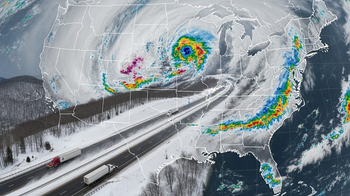
A fresh round of severe storms over the Midwest on June 18 is triggering tornado watches, power disruptions and mounting flight delays, creating difficult conditions for both residents and travelers across the central United States.
Get the latest news straight to your inbox!
Tornado Watches and Severe Storms From Illinois to Indiana
Publicly available outlooks show a volatile storm system tracking across the Midwest on Wednesday night into Thursday, focusing the greatest tornado concern over parts of Illinois, Indiana and neighboring states. Forecasters highlight an environment supportive of rotating supercell thunderstorms, with a corridor of heightened tornado potential extending from eastern Missouri across central Illinois into central Indiana.
Reports indicate that a tornado watch is in effect for dozens of counties in Indiana, including the Indianapolis metropolitan area, through the early hours of June 18. The watch follows multiple rounds of strong thunderstorms that swept across the region on June 17, bringing damaging winds, heavy downpours and frequent lightning. Local media coverage describes radar-indicated rotation and occasional tornado warnings as storms tracked east during the evening and overnight.
In nearby Illinois and parts of the Ohio Valley, severe thunderstorm warnings have been issued for storms capable of producing large hail and wind gusts strong enough to damage trees and power lines. Earlier in the week, a separate outbreak across the central United States had already produced confirmed tornadoes and structural damage in portions of Wisconsin, Illinois and Ohio, underscoring the persistence of a turbulent early summer pattern.
Weather guidance suggests the severe threat will gradually shift east into the Ohio Valley and interior Northeast later on June 18, but the risk for isolated tornadoes and pockets of destructive wind is expected to linger through at least the evening hours for portions of the Midwest.
Power Outages, Property Damage and Local Travel Disruption
The severe storms have already left visible impacts across several Midwestern communities. Local news outlets in states such as Ohio and Wisconsin describe downed trees, snapped utility poles and damage to outbuildings as intense cells moved through on Wednesday. In some locations, emergency crews have been working to clear debris from roadways while utility providers coordinate efforts to restore electricity.
In northeast Ohio, Wednesday night storms into early Thursday triggered multiple tornado warnings and cut power to thousands of customers, according to regional broadcast reports. Images shared by local media show tree limbs on vehicles, scattered debris and pockets of street flooding after torrential rain. Similar scenes have been reported in parts of Illinois and Indiana, where repeated rounds of heavy rain have saturated the ground and raised concern for additional flooding with any new downpours.
Surface travel is being affected as well. Temporary lane closures on interstates and secondary highways have been reported where fallen trees or power lines blocked traffic. Motorists are being urged in public advisories to avoid driving through flooded roadways, to monitor weather alerts frequently and to build in extra time if travel cannot be postponed.
These localized disruptions compound the broader regional strain brought on by the ongoing severe weather pattern, particularly in areas that have endured multiple storm systems in a short timeframe.
Stormy Skies Trigger Flight Delays at Major Midwest Hubs
The turbulent conditions are rippling through the air travel system, with Chicago and other key Midwestern airports experiencing delays and cancellations as storms develop and redevelop along major flight corridors. Aviation tracking services and airline operations updates show that hundreds of flights have been impacted as carriers reduce arrivals and departures during the most intense weather.
Chicago, a central hub for several major U.S. airlines, has seen some of the most significant knock-on effects. According to industry-focused coverage, a broader wave of disruptions tied to a mix of severe weather and operational challenges has produced thousands of delays and cancellations nationwide, with Chicago’s hubs frequently near the top of daily impact lists. Thunderstorms passing near the city can force ground stops or slow arrival rates, quickly leading to backlogs of aircraft and passengers.
Smaller regional airports across the Midwest are also feeling the strain when storms cross their airspace. Flights connecting through Indiana, Ohio, Missouri and Wisconsin have encountered diversions, holding patterns or outright cancellations when convective cells build along approach and departure routes. As storms shift east with time, airlines may need to adjust schedules at airports in the Ohio Valley and eventually the Northeast.
The combination of convective weather, air traffic control flow restrictions and aircraft repositioning challenges means that even travelers flying from cities with clear skies on June 18 could experience delays tied to the Midwest outbreak.
What Travelers Can Expect Over the Next 24–48 Hours
Forecast discussions suggest that the core severe weather risk will slowly migrate from the central Midwest into the Ohio Valley and portions of the interior Northeast through late June 18 and into June 19. As the system moves, the corridor of highest tornado and damaging wind potential will also shift, but scattered strong storms may persist in its wake across sections of the central United States.
For air travelers, publicly available airline and airport updates indicate that recovery from widespread delays often lags behind the storms themselves. Aircraft and crews may be out of position after an evening of severe weather, resulting in follow-on disruptions the next morning even if skies have partially cleared. Travelers connecting through major hubs such as Chicago or other Midwestern gateways should anticipate possible schedule changes and gate swaps as airlines work to re-balance operations.
Travel experts commonly recommend several practical steps in such situations. Keeping airline apps and mobile notifications enabled allows passengers to receive rebooking options quickly if a flight is canceled. Checking flight status frequently on the day of travel, arriving early at the airport and having flexible backup itineraries in mind can also reduce stress during an evolving weather event.
On the ground, motorists and rail passengers in the Midwest and downstream regions may encounter additional rounds of heavy rain, localized flooding and strong wind gusts. Public information from weather agencies continues to emphasize the importance of monitoring local forecasts closely, especially for those planning long-distance drives or outdoor activities through the end of the week.
Safety Tips for Visitors and Residents in the Impact Zone
For travelers currently in the Midwest, staying aware of rapidly changing conditions is essential. Severe storms with tornado potential can develop quickly, particularly during the late afternoon and evening. Visitors unfamiliar with the region are encouraged by publicly available safety guidance to keep mobile devices charged, enable weather alerts and identify interior shelter areas in hotels or accommodations in case warnings are issued.
Outdoor activities such as hiking, camping or attending large events carry added risk on days with elevated severe weather potential. Many event organizers and venue operators rely on weather monitoring tools and may suspend or postpone activities when lightning, high winds or tornado threats arise. Travelers planning to attend outdoor gatherings on June 18 and 19 across the Midwest and Ohio Valley may wish to confirm schedules before departure and have alternate indoor plans available.
Those driving long distances across the region should pay attention to changing sky conditions and avoid stopping under highway overpasses during storms, a practice that safety campaigns caution can increase risk from wind and flying debris. Pulling off the road at a safe location and seeking sturdy shelter is generally recommended when intense storms approach.
With severe weather season in full swing, the current outbreak serves as a reminder that tornadoes, destructive winds and flash flooding can all affect travel plans with little notice. Careful monitoring of forecasts, flexible itineraries and a focus on basic safety measures can help residents and visitors navigate the Midwest’s unsettled weather in the days ahead.