
More news on this day
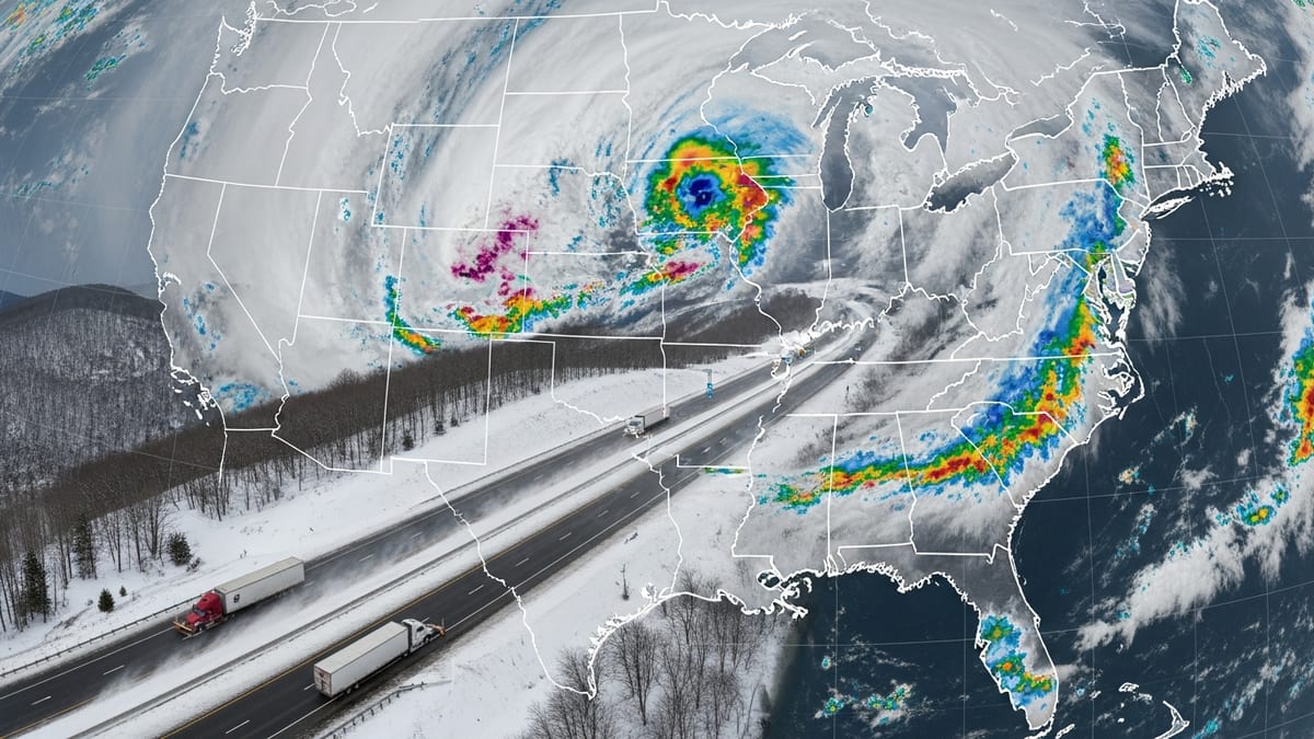
A powerful June storm system sweeping across the Midwest on June 17, 2026 is bringing a heightened risk of tornadoes, destructive winds and torrential rain, with travel hubs in Chicago, Cincinnati and Indianapolis already reporting delays and disruptions.
Get the latest news straight to your inbox!
Storm system targets major Midwest corridors
Publicly available outlooks from national forecasters describe a classic early summer severe weather setup over the central United States, with warm, humid air surging northward and colliding with a strong upper-level disturbance. Chicago and northern Illinois sit near the center of a Moderate risk area for severe thunderstorms, while much of Indiana and Ohio faces an enhanced threat of dangerous storms through Wednesday evening.
The Storm Prediction Center’s convective forecasts highlight the potential for long-tracked tornadoes, swaths of damaging straight-line winds and very large hail from eastern Iowa through Illinois into Indiana and western Ohio. For travelers moving through Chicago, Indianapolis and Cincinnati, this corridor includes several of the nation’s busiest interstate and aviation routes, increasing the likelihood that even localized tornadoes or power outages could have outsized impacts on regional mobility.
Recent days have already underscored the vulnerability of the region. Published coverage from Chicago outlets indicates at least 17 tornadoes were confirmed across Illinois and Indiana during storms last week, damaging trees, structures and power infrastructure and leaving hundreds of thousands without electricity. With soils saturated and cleanup still under way in some communities, additional high winds and heavy rain are raising concerns about renewed damage and flash flooding.
Weather briefings for Ohio and Indiana describe an environment primed for repeated storm development through Wednesday night, with multiple rounds of thunderstorms expected to track along the same general path. This pattern, sometimes described as training storms, can quickly overwhelm urban drainage systems and low-lying rural areas, compounding the hazards for motorists and rail traffic.
Air travel disruptions ripple from Chicago to Cincinnati
Chicago O’Hare International Airport, consistently among the world’s busiest aviation hubs, is emerging as a focal point of weather-related travel problems. Local weather pages on June 17 reference thunderstorms sweeping across the metropolitan area, with strong storms prompting warnings and causing delays at the city’s major airports as lightning, low visibility and wind shear force temporary ground stops.
Travel industry discussion boards and airline alerts indicate that at least one major U.S. carrier has issued a Midwest severe weather travel waiver for June 17 that specifically lists Chicago O’Hare, Chicago Midway and Indianapolis among the affected airports. Such waivers typically allow customers to change flights without additional fees when itineraries pass through designated cities within a defined date range, signaling that carriers anticipate significant schedule disruptions as storms move through.
Cincinnati and northern Kentucky are positioned downstream from the core of the severe weather threat, but forecasts still point to strong thunderstorms and potential tornadoes as the system shifts east. As has been seen in previous Midwest outbreaks, even if Cincinnati/Northern Kentucky International Airport avoids a direct hit from the strongest cells, cascading delays from aircraft and crews arriving late from Chicago and Indianapolis can snarl operations well into the evening.
Passengers connecting through the region on June 17 are being advised, via airline and airport bulletins, to monitor their flight status frequently, consider earlier departures where possible and prepare for extended time at terminals. With storms expected to persist into the nighttime hours, the risk of rolling delays and re-routes remains elevated for both domestic and some transatlantic itineraries that rely on Midwest connections.
Tornado and flooding risk complicate road and rail plans
For travelers on the ground, the same atmospheric ingredients that threaten aviation are creating hazardous conditions along interstate highways and key rail lines that converge on Chicago, Indianapolis and Cincinnati. Forecast discussions for the Midwest emphasize the potential for embedded supercells within larger storm complexes, a scenario that can produce quick-forming tornadoes with limited visual warning, especially after dark.
Interstate corridors including I-65 between Chicago and Indianapolis, I-70 across Indiana into Ohio, and I-74 and I-75 near Cincinnati are all within the broader severe weather risk zone. Heavy rainfall rates of one to two inches per hour, mentioned in multiple regional outlooks, increase the likelihood of standing water on roadways and rapid-onset flash flooding in urban underpasses and rural stream crossings.
Rail operations across the region may also face weather-related slowdowns. Strong crosswinds, lightning and potential debris on tracks can prompt dispatchers to reduce speeds or hold trains, affecting both passenger services and freight traffic that depend on Chicago as a central hub. With recent tornado damage in parts of Illinois and Indiana still being assessed, additional severe weather raises the prospect of new localized track and signal outages.
Travel planners note that compared with winter storms, severe convective outbreaks like the one forecast for June 17 tend to be more localized but also more unpredictable, with conditions shifting rapidly over short distances. This makes it especially important for drivers and rail passengers to rely on real-time information from trusted weather sources rather than static forecasts issued many hours earlier.
Travelers urged to build flexibility into June itineraries
As the storm system unfolds, publicly available guidance from transportation and emergency management agencies across the Midwest is emphasizing flexibility and situational awareness for anyone traveling through the affected corridor. For air passengers, this includes verifying that contact information is up to date in airline profiles so that rebooking notices and gate changes can be received promptly, and considering carry-on luggage where possible to speed transfers if tight connections are disrupted.
For those driving between Chicago, Indianapolis and Cincinnati, travel advisories recommend allowing extra time, identifying alternate routes and being prepared to pause journeys if warnings are issued along the way. Motorists are encouraged to avoid flooded roadways and to seek substantial shelter rather than attempting to outrun approaching storms, especially on congested urban expressways or in open rural stretches where safe options may be limited.
Rail and intercity bus passengers, meanwhile, may encounter slower trips or schedule adjustments as operators navigate changing conditions. Published service updates in previous Midwest severe weather events show that some carriers have temporarily suspended late-night departures when tornado potential remained high, then resumed operations once the most dangerous storms cleared key corridors.
With the peak of the U.S. summer travel season approaching, the June 17 severe weather episode underscores how quickly conditions in the Midwest can shift from routine early-summer heat to high-impact storms. Travelers headed through Chicago, Cincinnati and Indianapolis over the next 24 hours are being encouraged by publicly available information to treat tornado and flood watches as signals to reevaluate timing and routing, with the goal of keeping both delays and safety risks to a minimum.