
More news on this day
Another surge of moisture is poised to soak parts of the United States on Saturday, with locally intense downpours expected to trigger street flooding and slow travel in several metropolitan areas.
Get the latest news straight to your inbox!
Storm Systems Target Multiple Regions This Weekend
Weather outlooks for Saturday point to a broad swath of unsettled conditions from the Southern Plains into the Gulf Coast and portions of the East Coast. A slow-moving upper-level system over North Texas is drawing in humid air from the Gulf of Mexico, while separate disturbances over the western Gulf and the Atlantic are feeding additional bands of showers and thunderstorms into nearby states. Publicly available forecasts describe a setup favoring repeated rounds of rain rather than a single, fast-moving line of storms.
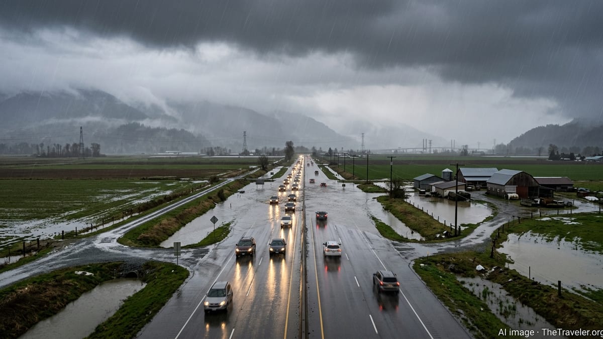
In North Texas, regional coverage from local outlets notes that several inches of rain have already fallen in recent days, leaving soils saturated and drainage networks under strain. A flood watch is in effect through Sunday afternoon, with meteorologists warning that new storms could push totals to 6 or 8 inches in some pockets by the end of the weekend. Even where amounts remain lower, brief but intense downpours are expected to overwhelm low-lying intersections and underpasses.
Farther south along the Gulf Coast, Houston and surrounding communities are bracing for another burst of tropical-style showers and storms on Saturday. Forecast discussions highlight the potential for slow-moving cells and training thunderstorms that pass repeatedly over the same neighborhoods. Local weather services and independent forecasters in the city have issued low-level flood alerts, emphasizing that street flooding is likely to develop more quickly than usual because of rain earlier in the week.
Along the Eastern Seaboard, New York City emergency planners have issued a travel advisory covering Saturday into early Sunday, citing National Weather Service guidance for moderate to occasionally heavy rain. Official notices warn that even modest storm totals could cause ponding and localized flooding on highways and surface streets, particularly in underpasses and areas with poor drainage. City agencies report that they have been clearing catch basins and removing debris in advance of the wetter period in an effort to keep water moving off the roads.
Why Street Flooding Is a Primary Concern
Forecasters and emergency managers are focusing on street flooding rather than large-scale river flooding because of how this particular pattern is expected to unfold. Many of the storms on Saturday are likely to be slow-moving and highly efficient rain producers, capable of dropping one to two inches of water in a short window. In paved urban environments, that kind of burst can quickly exceed the capacity of storm drains, even when longer-term rainfall totals are relatively modest.
In cities such as Dallas, Fort Worth, Houston and Oklahoma City, recent rain has already primed the ground. Reports from regional weather services note that creeks and small tributaries are running high, and that runoff from additional showers will reach streets and storm sewers faster than usual. When drains back up, intersections can become impassable within minutes, particularly where roadways dip or where gutters are partially blocked by leaves and trash.
New York City faces a similar dynamic, though the anticipated rainfall is lower compared with some areas of Texas and Oklahoma. Travel advisories distributed through the city’s notification systems caution that periods of heavier rain may coincide with busy evening and overnight travel windows. The combination of high traffic volumes, ponding water and limited visibility is expected to increase the risk of fender-benders and delays on major approaches into Manhattan and other boroughs.
Even outside the core urban centers, transportation corridors are vulnerable when storms repeatedly track along the same path. In parts of central Oklahoma, outlooks highlight the risk that slow storms will produce localized but intense rain over suburban arterials and rural low-water crossings. Under those conditions, water can rise over roadways even though nearby fields and neighborhoods may not appear severely affected.
Travelers Urged to Anticipate Delays and Detours
With many people on the move for weekend events, sports and early-summer getaways, Saturday’s forecast carries particular implications for drivers and air travelers. In Texas, local media advisories recommend allowing extra time for trips across the Dallas–Fort Worth and Houston metropolitan areas, noting that visibility may drop quickly under the heaviest cells. Traffic data from previous storms in these regions show that even short-lived downpours can trigger chain-reaction slowdowns along key freeways.
In New York City, the travel advisory encourages residents and visitors to reconsider non-essential trips during peak rainfall periods. Publicly posted guidance suggests that those who must drive should stick to major routes, which are more likely to be pretreated and cleared, and avoid shortcuts through known low spots. Mass transit systems in large cities typically continue operations during heavy rain, but riders have been advised to expect sporadic delays where tracks and access roads intersect with flood-prone locations.
Airports in the affected regions may also see ripple effects as the storms move through. Thunderstorms near major hubs in Texas and the Northeast often force temporary ground stops or reduce the number of active runways, which can back up departures and arrivals nationwide. While airlines had not announced broad waivers for Saturday as of early morning, previous events of this kind have led carriers to adjust schedules on short notice once storm timing becomes clearer.
For those traveling by road between regions, the patchy and evolving nature of the rain means conditions can change quickly along a single route. Motorists leaving drier areas may encounter heavy rain bands a few hours into their drive, particularly across the Interstate corridors that cross North Texas and the lower Mississippi Valley. Drivers are being reminded by public safety campaigns that turning around rather than driving through water-covered roads remains the safest option when flooding is encountered.
Practical Steps to Reduce Flood Impacts
Emergency preparedness materials emphasize that modest actions taken before storms arrive can significantly reduce the disruption caused by street flooding. Residents are encouraged to check nearby storm drains and gutters for leaves, litter and other debris that could impede water flow. In past events, neighborhoods where drains were cleared ahead of time have reported fewer standing-water issues than nearby areas left untouched.
Homeowners in low-lying locations and along historically flood-prone streets are also urged to move vehicles to higher ground before the heaviest rain begins. Insurance and disaster-planning resources note that a substantial portion of storm-related vehicle damage during heavy rain events occurs when parked cars and trucks are submerged in quickly rising water. Shifting vehicles by even a block or two can sometimes be enough to avoid that outcome.
Travel planners recommend adjusting departure times to take advantage of lulls in the rain where possible. Forecast graphics published by local television stations and weather services often highlight windows of lighter precipitation during the daytime hours, especially ahead of the most persistent evening storms. For travelers with flexible itineraries, leaving earlier in the day or waiting until conditions improve late Saturday night or Sunday morning may reduce the risk of encountering flooded routes.
Authorities and weather services stress that the risk from this weekend’s storms lies less in their novelty and more in their timing and repetition. After a week of intermittent rainfall in several regions, another round of heavy showers on Saturday is expected to tip some drainage systems past their limits. For residents and visitors alike, staying attentive to updated forecasts and being prepared to change plans remain the most effective ways to stay ahead of the water.
Outlook Beyond Saturday
Beyond the immediate concern for Saturday, forecast models suggest that showers could linger into Sunday in parts of Texas, Oklahoma and the Northeast. However, meteorologists expect coverage and intensity to gradually diminish as the upper-level systems responsible for the current round of storms begin to weaken or shift eastward. Where this occurs, drainage systems should have more time to recover between showers, reducing the likelihood of additional, widespread street flooding.
In Houston, regional forecast discussions point to the possibility of a somewhat drier pattern by late Sunday, with only isolated storms expected compared with the more organized clusters anticipated on Saturday. North Texas may still see scattered activity, but amounts appear likely to be lower than those projected for the first half of the weekend. If that trend holds, the risk of new flooding should decline, even though some localized trouble spots could persist until standing water fully recedes.
For New York City and neighboring areas, light, lingering rain is possible into early Sunday, after which a gradual drying trend is expected. Travel advisories indicate that any remaining showers are less likely to produce significant impacts once the most concentrated moisture moves offshore. Nonetheless, damp roads and residual ponding may continue to slow traffic in some locations.
Looking ahead, climate and seasonal outlooks continue to highlight the likelihood of recurrent heavy rain events in many parts of the country as warm-season patterns strengthen. While not every storm will produce flooding, the experience of this weekend underscores how quickly conditions can deteriorate when slow-moving systems interact with saturated ground and dense urban development. For travelers planning trips later in the season, building weather monitoring and flexible routing into itineraries is increasingly seen as a practical necessity rather than an optional extra.