


I reached Naguabo on a humid Saturday morning, steering my rental car off Highway PR-53 and onto PR-31 as the Caribbean flashed between palm trees to my right and the Luquillo Mountains rose to my left. I had two unhurried days based in Luquillo and chose to devote one of them entirely to Naguabo, making it a long day trip rather than an overnight. Before arriving, I pictured “just another” coastal town with a boardwalk and seafood. What I found instead was a municipality split into three very different worlds: a low-key waterfront lined with pastel buildings and fritter stands, a river valley where locals spend whole afternoons in cold pools under boulders, and a quiet back door into El Yunque where the rainforest feels almost private.
Get the latest updates straight to your inbox!
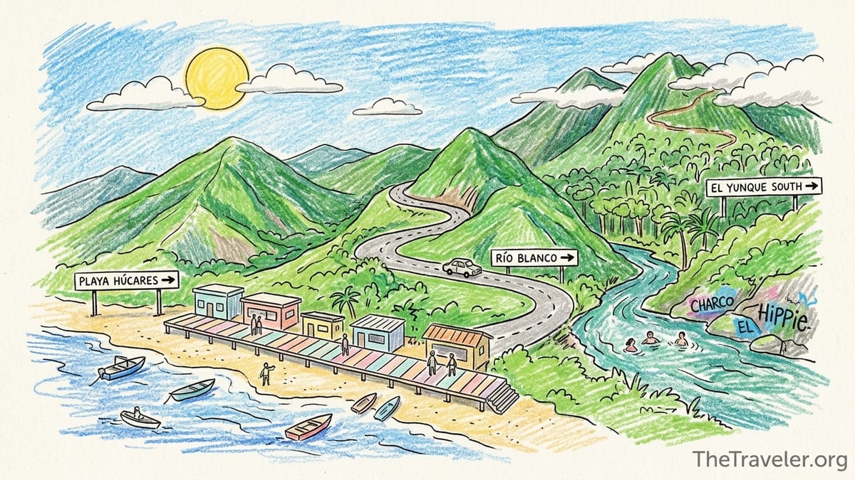
Understanding Naguabo’s Layout Before You Go
Naguabo sits on Puerto Rico’s east coast, stretching from the Caribbean Sea up into the Luquillo Mountain Range. Discover Puerto Rico describes it as a small coastal municipality whose territory runs from the shoreline into the mountains, cut by six rivers including Río Blanco, Río Daguao and Río Santiago. That geography matters for planning, because the places you are likely to visit sit in three distinct zones that do not feel walkable between each other. You will want a car and a rough plan for how you move among them.
The first zone is the town itself and the waterfront area known as Playa Húcares or the Malecón de Naguabo. This is where you will find the pastel boardwalk, seafood restaurants, bars and a short strip that can feel unexpectedly lively on weekends. The second is the river-country interior around Río Blanco and small communities like Río Blanco barrio and Florida, where people head for swimming holes such as Charco El Hippie and more secluded spots upriver. The third is the southern side of El Yunque National Forest, accessed from Naguabo via PR-191 South toward Rio Sabana Recreation Area, a much quieter alternative to the crowded northern entrance in Río Grande.
Driving between these zones is straightforward but takes more time than the map suggests. From Playa Húcares up toward the Río Blanco area I needed about 25 to 30 minutes, climbing on PR-31 past small colmados and roadside fruit stands before turning onto narrower mountain roads. From the river up toward the El Yunque south entrance, it was another 15 to 20 minutes on curvy pavement, then a final stretch of pothole-dotted road to the forest gate. None of these distances are long, yet the combination of sharp curves, slow local traffic and sudden tropical downpours meant I rarely exceeded 30 to 35 miles per hour.
Before visiting, I expected Naguabo might feel like an overspill of Fajardo and Luquillo, catering mainly to weekend visitors from San Juan. Instead, outside the immediate boardwalk the town felt rooted and local, with most people I encountered clearly from the area. English was less commonly spoken than in Luquillo or Condado, and prices reflected that: full seafood plates at the waterfront often came in under what a single appetizer might cost in San Juan. That mix of authenticity and quiet countryside is Naguabo’s main draw, especially for travelers willing to drive a bit for rivers and rainforest.
Playa Húcares and the Waterfront: First Impressions
My first stop was Playa Húcares, the waterfront esplanade that locals simply call the Malecón. Official descriptions emphasize that this stretch is less a true swimming beach and more a boardwalk and small harbor, and that matched my experience. As I turned off PR-3 and followed signs to Playa Húcares, the road narrowed past simple concrete homes before suddenly opening up to a wide bay framed by fishing skiffs and low, colorful buildings. I parked in an informal gravel lot at the western end of the strip, a spot that was free and, on a late morning, barely a quarter full.
The boardwalk itself runs only a few blocks, but it packs in a mix of attractions: modest guesthouses, ice cream windows, family-owned seafood restaurants and stands frying the town’s specialty pastelillos de chapín, fritters filled with trunkfish that Discover Puerto Rico highlights as a Naguabo classic. At one kiosk, two pastelillos and a cold drink cost less than a typical coffee in Old San Juan, and I ate them leaning on the seawall, watching families launch small boats into the still bay. Music drifted from a bar even before noon, not blasting, but enough to feel like a weekend outing spot rather than a quiet fishing pier.
Parking at Playa Húcares can tighten quickly as the day wears on, particularly on Sundays and holidays when people from Humacao and Ceiba arrive for lunch. By mid-afternoon, the gravel lot I had used was almost full, and the parallel spots directly on the strip were turning over constantly. Traffic still flowed, but drivers slowed to look for spaces and pedestrians crossed anywhere, so patience mattered. Compared with the bottlenecks I have seen in Luquillo’s kiosks area, though, Naguabo’s congestion felt modest. I never spent more than five minutes finding a space.
The heat on the waterfront was my first reality check. Naguabo carries the nickname “El Pueblo de los Enchumbaos,” associated with its heavy rainfall, but when the sun was out the humidity was intense. The concrete boardwalk reflected heat and with only occasional shade from awnings I found myself ducking into restaurants and colmados just to cool down. Showers built up quickly over the mountains in the early afternoon. Around 2 p.m. a gray curtain rolled in from the interior, bringing a hard ten-minute downpour that cleared most of the boardwalk, then just as quickly broke up, leaving everything steaming.
From Coast to Rivers: Exploring the Río Blanco Interior
Leaving the waterfront for the river country reinforced how compact yet layered Naguabo is. From Playa Húcares I drove back to PR-3, then cut inland on PR-31 toward Río Blanco. The first section is a standard two-lane highway, but after roughly 10 to 15 minutes the surroundings shifted: roadside mechanics gave way to thick bamboo, plantain groves and houses perched on stilts above steep ravines. Cell reception, strong by the waterfront, began to flicker between 4G and no signal depending on the curve. I had cached offline maps beforehand and was glad I did, since several river access points are unsigned or marked only with handwritten boards.
Río Blanco is one of Naguabo’s principal rivers, rising in the mountains and running roughly 8 to 9 miles before reaching the Caribbean. Local guides and municipal projects highlight it as both the area’s main water source and a recreational corridor dotted with natural pools and waterfalls. One of the best known spots is Charco El Hippie, a wide pool beneath a rock face covered in graffiti, reached by a short walk from the roadside. When I arrived late morning on a weekend, a handful of cars were already lined up on the shoulder and under trees, but the atmosphere felt resolutely local: multi-generational families grilling, teenagers jumping from rocks and vendors selling cold drinks out of coolers.
The path down to the water at Charco El Hippie was short but required careful footing on wet, sloping rock. After overnight rain, the river ran high and brownish green, and several people mentioned that swimming is safest when the water looks clearer and lower. There are no lifeguards, no formal facilities beyond occasional informal trash cans and sometimes a portable toilet at busier spots, and very limited signage warning about flash floods. I kept an eye on the sky and left when clouds thickened. In conversations, locals repeatedly advised checking forecasts and avoiding rivers in the hours after heavy rain higher up in the mountains, both in Naguabo and across eastern Puerto Rico.
Compared with more polished river experiences closer to San Juan, like some of the developed bathing areas in Río Grande, Naguabo’s river country felt raw and uncurated. That had advantages and drawbacks. On the positive side, there was space to spread out and a sense of being folded into local weekend life rather than a packaged excursion. On the downside, trash around popular pools was noticeable, and access points could be easy to miss or involve clambering over wet rocks with no railings. I left appreciating the honesty of the place, while wishing for better basic infrastructure and more visible safety messaging.
Driving Up to El Yunque’s Southern Side
Naguabo offers one of the lesser-used access corridors to El Yunque National Forest. Instead of heading to the main northern entrance on PR-191 in Río Grande, you can drive north from Naguabo on PR-191 South toward the Rio Sabana Recreation Area, essentially approaching the rainforest from behind. Official Forest Service material notes that this southern road is cut off from the northern section by a long-ago landslide, so you cannot drive through the forest from south to north, but you can reach rivers, picnic shelters and trailheads in a quieter setting.
From the Río Blanco area, the route to Rio Sabana began on PR-31, then turned onto PR-191 South near the small community of Florida. The pavement narrowed and the curves tightened almost immediately. This is one of those Puerto Rican mountain roads where posted speed limits feel theoretical. I often crept around blind corners in first or second gear, honking lightly on the tightest bends as local drivers do. Potholes increased as I climbed, and in shaded sections permanent wet patches suggested frequent runoff. After roughly 20 to 25 minutes of steady uphill driving from the valley, I reached a gate that typically marks the boundary of the national forest.
On the day I visited, the vehicle gate on PR-191 South remained closed, consistent with recent visitors’ reports that this road segment is often gated for safety. From there, I parked along the roadside where it widened and continued on foot. The walk along the pavement into the forest was almost eerily quiet compared with the bustle of the north side. Within ten minutes I could hear only the river and occasional birds. A Forest Service map of the PR-191 South recreation corridor shows picnic structures, restrooms and the Rio Sabana Recreation Area further up the road, but access to specific sites can change after storms, so checking recent updates before you go is smart.
Weather shaped this portion of my day more than any other. Naguabo’s nickname as a drenched town proves accurate near the forest boundary. Even though the coast was bright and hot when I left, low clouds clung to the ridges of the Luquillo Mountains by midday, and intermittent showers moved through with little warning. My rain jacket went on and off several times in an hour. The upside is that temperatures at elevation felt noticeably cooler than at the waterfront or along Río Blanco, making this side of El Yunque appealing for travelers who want rainforest atmosphere without long or strenuous hikes. The main caution is that road conditions can deteriorate quickly after heavy rain, with fallen branches and slick mossy patches on the pavement.
Practicalities: Weather, Roads, Reception and Food
Spending a full day crisscrossing Naguabo gave me a practical sense of what makes the place comfortable or frustrating to explore. The two dominant factors were weather and driving. On the coast, heat and full sun were the main challenge. Between late morning and mid-afternoon, the combination of concrete, still air and high humidity made even short walks feel taxing without frequent shade or hydration. I was glad to have light clothing and a spare T-shirt to change into between the waterfront and the river. Up in the interior, sudden showers were the bigger issue, especially near El Yunque’s southern edge, where rainfall patterns are influenced by the rainforest microclimate.
Road conditions varied from good to mildly punishing. The main arteries PR-3 and PR-53 are multi-lane highways in solid shape. PR-31, which links the coast to the Río Blanco area and onward toward PR-191 South, is two-lane and reasonably maintained but full of curves and occasional rough patches. The more minor roads up river valleys and into hillside communities transition to narrow lanes with uneven shoulders, potholes and limited guardrails. None of it demanded four-wheel drive on a dry day, but I would hesitate to make some of the steeper climbs in a very low-clearance vehicle after extended rain.
Mobile reception mirrored the terrain. Around the town center and Playa Húcares I had smartphone coverage strong enough for navigation and messaging. As I climbed toward Río Blanco, coverage dipped in and out, depending on my carrier, and near the forest border on PR-191 South it effectively disappeared, with only a faint signal returning at occasional bends. That made it important to download offline maps and store key addresses beforehand, including the turnoffs for Charco El Hippie and any guesthouses or farms you plan to visit in the interior.
Restaurant patterns also shifted with location. On the waterfront, most seafood restaurants clustered along the Malecón kept weekend hours that skewed late. Several were barely waking up around 11 a.m. yet packed by 3 or 4 p.m., with music rising and fried fish plates appearing in constant rotation. In contrast, away from the coast dining options grew thinner. A small bakery near Río Blanco sold coffee, pastries and simple sandwiches early in the day, but by late afternoon shutters were down. If you plan to spend long hours along the river or in the forest corridor, stocking up on snacks and water in town before heading inland is wise, since there are no formal concessions at most river access points or at the southern El Yunque gate.
How Naguabo Feels Compared with Fajardo, Luquillo and San Juan
Travelers used to Puerto Rico’s better-known east coast hubs will likely notice Naguabo’s different tempo. Compared with Fajardo, which centers around a marina, ferry terminal and a broad array of tour companies, Naguabo felt almost purely local in its day-to-day rhythm. There are fishing boats at Playa Húcares, but you do not see rows of catamarans advertising snorkeling trips or kiosks selling bio-bay packages. Instead, the waterfront leans toward family lunches, cold beers, and kids riding scooters along the boardwalk while parents watch the sea air thicken toward evening.
Against Luquillo, Naguabo’s contrast is more subtle. Luquillo combines a extensive beach, a large complex of food kiosks and proximity to the main El Yunque entrance on PR-191 North. It has developed a reputation among visitors for being relaxed but firmly on the tourist map. English is commonly spoken, and menus often list burgers, tacos and cocktails beside Puerto Rican staples. In Naguabo, English was less common outside the waterfront strip, and menus leaned more heavily into local seafood and fritters. Prices reflected that difference. A plate of garlic shrimp with sides on the Malecón cost noticeably less than a similar dish at popular Luquillo kiosks or beach bars, and snacks around Río Blanco were priced for residents rather than tourists.
Compared with San Juan, the distinction is sharper still. In Condado or Old San Juan, the tourism infrastructure is visible everywhere: branded hotels, tour desks, multilingual signage and rideshare cars shuttling constantly. In Naguabo, lodging and services are present but much more dispersed and small scale, often family-run guesthouses or apartments rather than major hotels. The town plaza felt alive but not curated for visitors, with people running errands, chatting under trees and teenagers practicing dance routines by the church steps. For travelers who crave nightlife, cocktail bars and easy walkability between multiple dining options, Naguabo will likely feel quiet.
That quiet is precisely what some visitors will appreciate. In my experience, Naguabo worked best as a daylong counterpoint to busier bases. It offered a concentrated dose of local flavor and striking landscapes without heavy commercialization. At the same time, the relative lack of structure requires a bit more self-sufficiency: comfort driving mountain roads, basic Spanish phrases, and the willingness to carry your own supplies to rivers and trails. Those used to the convenience of Fajardo marinas or San Juan tour operators may find the DIY aspect refreshing or frustrating, depending on their style.
What Surprised Me, What Disappointed Me, and What I Would Change
The biggest surprise in Naguabo was how quickly the environment shifted from flat sea-level town to immersive mountain and river scenery. Within less than half an hour of leaving the Malecón, I found myself pulling over just to stare at peaks rising above layers of mist and listening to the rush of water below the road. Discover Puerto Rico’s description of the municipality as stretching from sea to mountain felt vividly accurate on the ground. I had underestimated how complete that transition would feel within such short driving distances.
Another pleasant surprise was the atmosphere at Playa Húcares. In photos the boardwalk can look slightly worn, which is accurate in parts, but in person the mix of bright paint, fishing boats and locals chatting over plates of fried fish and tostones felt genuinely warm. Trying Naguabo’s famed pastelillos de chapín might sound like a tourist cliché, but they were genuinely delicious: crisp, not overly greasy, and served with an easy smile from a vendor who seemed more focused on greeting neighbors than courting visitors.
What disappointed me were mainly issues of maintenance and information. Trash at some river spots around Río Blanco was disheartening, especially near popular pools reachable directly from the road. There was also a noticeable lack of clear public signage about river safety, parking etiquette and restroom availability. At the southern El Yunque gate, I would have appreciated a simple, updated notice explaining exactly what was open further up the road, how far it was to the Rio Sabana Recreation Area on foot and any recent storm damage. Instead, I relied on prior research and conversations with other visitors, which not every traveler will have time for.
If I were to do Naguabo again, I would start earlier and commit to either a river day or a rainforest day rather than trying to combine both with the waterfront. On my visit, dividing time among Playa Húcares, Río Blanco and PR-191 South meant I was always aware of the clock. On a return trip, I would spend a full morning and early afternoon rotating among two or three river pools, bring a proper picnic and perhaps stay in local accommodation in the interior to feel the evening quiet. On another day I would dedicate several hours to walking the southern El Yunque road, exploring the Rio Sabana area if accessible, then finish with an early seafood dinner at the Malecón as the bay settles into dusk.
Is Naguabo Worth a Dedicated Stop, and For Whom?
After a full day exploring Naguabo’s coast, rivers and rainforest edge, my conclusion is that it is worth a dedicated stop, but not for every traveler. If your priority is a classic Caribbean resort experience with wide sandy beaches, pool bars and minimal driving, you are likely better off basing yourself in Isla Verde, Condado or the resort enclaves of Río Grande and treating Naguabo as a short scenic detour if time allows. Similarly, if you prefer your rainforest neatly packaged with visitor centers, guided tours and well-marked loop trails, the northern entrance of El Yunque is a simpler choice.
Naguabo shines for a different audience. Nature-focused travelers who enjoy unhurried drives, river dips and semi-wild scenery will likely value how close everything feels once you get oriented. Photographers will appreciate the contrast between fishing boats at Playa Húcares, misty mountains above Río Blanco and the moss-draped pavement of PR-191 South. Independent travelers who like making their own picnic, following tips from locals at a bakery and lingering in places that are not heavily signposted will find Naguabo rewarding precisely because it has not been fully smoothed out for visitors.
For families, the calculus is mixed. The waterfront is easy enough with children, offering flat pavement for strollers and casual restaurants where a bit of noise is no problem. Some river spots, like the gentler edges of Charco El Hippie, can be family-friendly on low-water days, but the lack of lifeguards and variable water levels demand vigilance and conservative judgment. Older kids and teenagers who are strong swimmers and comfortable on rocks may love the adventure, but families used to lifeguarded pools and clear signage should be cautious.
Ultimately, Naguabo works best as a one or two day focus within a broader east coast itinerary that might also include Luquillo’s beaches, Fajardo’s marinas and the main El Yunque corridor. It rewards curiosity more than checklists. If the idea of weaving from a seafood lunch on a small-town boardwalk to a mountain river and then into a quiet corner of a rainforest road all in a single day appeals to you, Naguabo is a strong candidate for a dedicated stop.
The Takeaway
My day in Naguabo began with modest expectations and ended with a sense of having glimpsed three distinct versions of eastern Puerto Rico layered into one municipality. At the water’s edge, Playa Húcares presented an easygoing coastal scene rooted in fishing and family seafood outings. Just inland, the Río Blanco corridor revealed how deeply rivers shape daily life and weekend leisure here, for better and for worse. Higher still, the southern flank of El Yunque offered rainforest air and mountain vistas with hardly any crowds.
Logistically, Naguabo asks a few things of you: a rental car, comfort driving sinuous mountain roads, preparation for both heat and sudden rain and a willingness to navigate with imperfect signage and patchy cell service. In return, it offers genuine local flavor, accessible rivers and a quieter angle on Puerto Rico’s only tropical rainforest. It is not a town to rush through. Give it at least a dedicated day, come with flexibility and curiosity, and you are likely to leave feeling that the coast-to-mountain sweep described in brochures has become a personal experience rather than just a marketing line.
FAQ
Q1. Do I need a rental car to visit Naguabo’s coast, rivers and El Yunque south side?
Yes. The three main areas of interest in Naguabo are spread out, connected by curvy rural roads with limited public transport and inconsistent rideshare coverage, so having a rental car offers far more flexibility.
Q2. How long should I spend in Naguabo?
At minimum, plan a full day if you want to combine the waterfront, a river stop and some time on PR-191 South. If you are particularly interested in rivers or quiet rainforest roads, one overnight and two partial days will feel more relaxed.
Q3. Is the water at Playa Húcares good for swimming?
Playa Húcares functions more as a boardwalk and small harbor than a classic swimming beach. Most visitors come here to eat seafood, stroll the esplanade and watch boats rather than to swim, although there are calmer spots along the shoreline where locals sometimes wade.
Q4. What is driving like between Playa Húcares, Río Blanco and PR-191 South?
The main coastal roads are straightforward, but once you head inland expect narrow two-lane roads with frequent curves, hills and occasional potholes. Speeds are slow, visibility around bends can be limited and you should drive cautiously, especially after rain.
Q5. Is mobile phone reception reliable in Naguabo?
Reception is generally good around the town center and Playa Húcares, but it often becomes spotty as you climb toward Río Blanco and the El Yunque south entrance. It is wise to download offline maps and save key locations before leaving the coast.
Q6. Are there facilities at the rivers and at El Yunque’s southern entrance?
Facilities at river spots vary and are usually basic, sometimes limited to informal parking areas and occasional trash cans. Around PR-191 South, there may be picnic areas and restrooms further inside the forest, but access can change after storms, so do not assume services will be available at every stop.
Q7. Is Naguabo suitable for families with children?
Naguabo’s waterfront is relatively easy with children and its casual restaurants are family-friendly. River areas and the southern El Yunque road can also be enjoyable, but lack lifeguards and have slippery rocks and changing water levels, so families should be cautious and choose calmer spots on good-weather days.
Q8. How does Naguabo compare price-wise with Luquillo or San Juan?
In general, meals and snacks in Naguabo, especially away from the coast, tend to cost less than in San Juan’s tourist zones or at popular Luquillo kiosks. Lodging options are fewer and more modest, but everyday expenses like fritters, simple plates and drinks often feel refreshingly local in price.
Q9. Can I drive through El Yunque from Naguabo to the main northern entrance?
No. The road that once connected the southern and northern sections of PR-191 inside El Yunque has long been interrupted by a landslide. You can access parts of the forest from Naguabo’s side, but you cannot drive all the way through to the northern entrance.
Q10. Is Naguabo worth a special trip if I am already visiting El Yunque from the north?
If you enjoy quieter, less developed areas and are comfortable with self-guided exploration, Naguabo merits a dedicated visit for its distinct waterfront atmosphere, river country and the different perspective it offers on El Yunque from the south.