


The Navajo Loop Trail in Bryce Canyon National Park is one of the most iconic short hikes in the American Southwest, but it is also one of the most regulated and seasonally affected. Before you head for those famous switchbacks beneath Thor’s Hammer, it pays to understand current trail conditions, how to read the maps correctly, and what to expect at different times of year. This guide walks you through the essentials so you can match what you see on your phone or paper map with what you will really find on the ground when you arrive.
Get the latest updates straight to your inbox!
Understanding the Navajo Loop Trail Layout
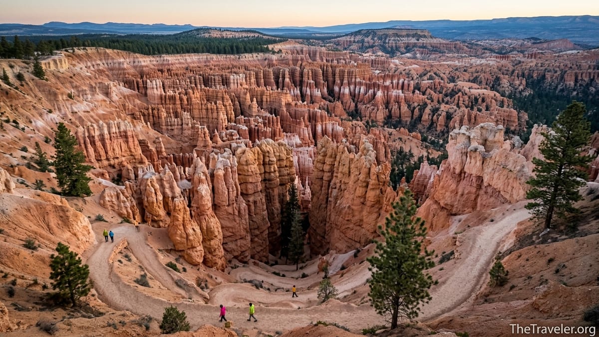
The Navajo Loop Trail is a roughly 1.3 to 1.4 mile moderate loop that begins and ends at Sunset Point on the Bryce Amphitheater rim. The loop drops about 550 feet into the maze of hoodoos below and typically takes most visitors 1 to 2 hours when walked at a steady but relaxed pace. The National Park Service classifies it as a moderate hike because of the steep switchbacks and elevation, not because of distance.
The loop has two distinct halves that matter when you look at maps or status updates. One side is commonly labeled “Wall Street,” a dramatic, narrow slot-like canyon with tight switchbacks and towering Douglas firs. The other side is labeled “Two Bridges” or sometimes “Twin Bridges,” named after a double arch in the rock. On an NPS trail map, you will usually see the loop drawn as a figure descending from Sunset Point, splitting into these two branches, then rejoining near the canyon floor before looping back to the rim.
At the bottom of the loop you will also notice junctions with other trails, which can be confusing on first glance. A signed intersection connects Navajo Loop to the Queens Garden Trail and to the Peekaboo Loop connector. Many park publications describe the combined “Queens Garden Navajo Loop” as one of the best 3 mile hikes in the park, and another map layer may show the longer “Figure 8” route that adds the Peekaboo Loop. When you review maps online, make sure you can clearly differentiate between the short Navajo Loop itself and these longer combinations so you do not accidentally commit to more mileage than you want.
Because the loop is in the heart of the main amphitheater, you will often see it emphasized in orange as a “moderate” trail on official NPS hiking maps. Commercial topographic maps, such as Trails Illustrated Bryce Canyon National Park or onX Backcountry, show the same layout but may include contour lines and elevation profiles that help you visualize how steep the initial descent and final climb are.
Finding Reliable Maps Before You Go
When you search for “Navajo Loop Trail map,” you will be flooded with options: screenshots from apps, social media graphics, and user drawn lines over satellite images. For accurate navigation and closure information, start with official sources first. The Bryce Canyon National Park website hosts a general park map that highlights the Navajo Loop and an interactive hiking map where you can click on the trail segment for distance, elevation change, and difficulty. This same map is usually mirrored on large printed panels at Sunset Point.
Before you arrive, it can be useful to download a high resolution PDF of the park map to your phone or print it for quick reference. Many travelers pair this with an offline GPS app to give them more detail on the trail. Apps such as onX Backcountry, Gaia GPS and AllTrails commonly show the Navajo Loop as a 2.1 to 2.4 kilometer circuit with recorded user tracks. While the precise mileage numbers may vary slightly between apps because of how the track was recorded, the shape and junctions will match what you see on the ground if the data is based on recent hikes.
Paper maps are still practical here. Visitors who stop first at the Bryce Canyon Visitor Center can usually pick up a free newspaper style guide that includes a simple hiking map with the Navajo Loop clearly labeled. For more detail, you can purchase a waterproof topographic map like the National Geographic Trails Illustrated Bryce Canyon sheet at the visitor center bookstore or at nearby outfitters in Bryce Canyon City. This kind of map is especially helpful if you plan to connect Navajo Loop with Queens Garden, Peekaboo Loop, or even longer routes such as the Fairyland Loop later in the day.
A useful real world approach is to compare what you see on your phone with the big relief model or wayside signs at Sunset Point itself before you start hiking. Many travelers arrive with an app open, then walk up to the trailhead sign and trace the loop with a finger to confirm where Wall Street, Two Bridges, and the connections to Queens Garden and Peekaboo actually lie. That quick check takes one or two minutes and can prevent the classic mistake of thinking you are on an easy rim trail when you are actually entering a steep descent into the amphitheater.
Current Conditions and Seasonal Closures
The single most important detail about the Navajo Loop is that it is not always a full loop. The Two Bridges side is open year round in most years, but the Wall Street side usually closes during winter and early spring when snow, ice, or repeated freeze thaw cycles create rockfall and mudslide hazards. As a result, maps alone are not enough. You need to cross check the status of each side of the loop before you hike.
The National Park Service updates trail conditions frequently during the colder months and after major storms. As of spring 2026, reports and ranger comments indicate that the Wall Street section is still prone to seasonal and post storm closures, while the Two Bridges section tends to reopen sooner once crews clear mud and debris. In practical terms, this means a March or early April visitor may see online reports that “Navajo Loop is open as an out and back via Two Bridges” or “Wall Street closed, loop not complete.” Travelers in late June or early October, on the other hand, often find that both halves are open and the full loop can be hiked in either direction.
On the ground, the clearest way to confirm conditions is to read the status board near the Bryce Canyon Visitor Center or at Sunset Point itself. You may encounter a large sign on the pavement at the top of the trail that states in bold letters that Wall Street is closed beyond a certain junction. Rangers sometimes place temporary barricades down on the trail as well if a section has been undercut by recent mudslides. If you are unsure or see conflicting information between an app and these physical signs, always treat the official National Park Service signage as the final word.
For real world timing, imagine a family arriving the first week of May. They checked their hiking app in March, which still showed the full Navajo Loop in green. When they reach the park, the ranger at the entrance station explains that a series of late storms has left lingering ice in Wall Street, so only the Two Bridges side is open as an out and back. With that information, the family adjusts their plan: they hike down Two Bridges to the junction, then turn left on Queens Garden and complete the “Queens Garden Navajo combination” instead of trying to force the closed loop. The experience is still excellent, but it aligns with what the conditions allow.
How to Interpret Elevation, Difficulty and Weather
Maps and condition reports only help if you understand what the numbers really feel like at over 8,000 feet. Bryce Canyon’s rim is high, and many visitors drive up from lower elevation desert towns such as Springdale or Kanab on the same day they hike. A 550 foot climb at sea level feels very different from that same climb at roughly 8,000 to 8,300 feet where oxygen is thinner and UV exposure is stronger.
On most maps, the Navajo Loop’s descent and ascent are depicted as tight clusters of contour lines where the trail switchbacks steeply. The first half mile may look short but in practice you will drop several hundred feet on packed dirt and occasional rocky steps. In dry summer conditions, fit hikers often descend from Sunset Point to the canyon floor in 15 to 20 minutes and climb back out in 25 to 40 minutes. In shoulder seasons, patches of ice or slushy snow can slow that same climb considerably, which is one reason the park closes Wall Street when conditions are unstable.
Weather adds an overlay that is not visible on the static map. Summer afternoons often bring building clouds and the possibility of lightning, even on days that begin clear. Because the Navajo Loop spends time in a narrow canyon section, the safest pattern is to start early, check the day’s thunderstorm forecast at the visitor center or park website, and avoid being deep in Wall Street if a storm is moving in. In winter and early spring, temperatures at the rim can be below freezing while the canyon floor feels more sheltered. Many winter hikers carry traction devices that slip over boots for extra grip on icy sections, especially if they plan to combine Navajo Loop with the Queens Garden Trail.
Older travelers and families with younger children sometimes underestimate how taxing the climb out will feel. A couple in their early 60s who walked the Queens Garden Navajo combination in late September, for example, reported that the final switchbacks on the Two Bridges side left them winded despite being regular walkers at home. They were glad they had looked at the elevation profile on their phone ahead of time and planned regular rest stops in patches of shade. Understanding the elevation change on the map allowed them to pace themselves rather than being surprised by a steep final push.
Practical Visitor Logistics: Parking, Shuttles and Timing
Maps of the Bryce Amphitheater area show just how close Navajo Loop is to other major viewpoints, and that proximity has a real effect on parking and crowds. Sunset Point, the trailhead for the loop, sits between Sunrise Point and Inspiration Point along the main park road. The lot at Sunset Point is not large relative to demand, and it fills quickly during peak season mornings and especially at sunset.
From roughly late spring through early fall, the park operates a free shuttle that stops at the main viewpoints and the visitor center. Many visitors choose to park their car at the visitor center or at the large lot outside the park entrance near Bryce Canyon City, then ride the shuttle to Sunset Point. On the map, shuttle stops are usually indicated by a bus icon. In practice, this saves the frustration of circling for a spot during busy hours and is especially helpful for RV drivers who may not fit easily into smaller rim lots.
Timing your hike around both crowds and weather will make a big difference. A typical summer pattern is that the first commercial tour buses start arriving mid morning, slowly filling Sunset Point and the upper portions of the trail by 10 or 11 a.m. Travelers who want quieter conditions often start from Sunset Point around 7 or 8 a.m. when the sun is just starting to reach into the amphitheater. The light on the hoodoos is soft, temperatures are cooler, and you share the switchbacks with far fewer people. Alternatively, some visitors hike Navajo Loop in the late afternoon and then stay at Sunset Point for the golden hour views over the amphitheater from the rim.
Bear in mind that the trailhead sits close to amenities but not directly beside restrooms or water. Maps of the area mark restrooms near the parking lots and at the general store, not down on the trail itself. In practice, you should use restrooms and fill water bottles before you walk to the railings at Sunset Point. Many hikers carry at least one liter of water per person, even in cooler seasons, because the uphill finish can feel surprisingly dry and exposed if the afternoon sun is strong.
Combining Navajo Loop with Other Bryce Canyon Trails
When you look at the park’s hiking map, the Navajo Loop rarely appears on its own. Instead, it forms one piece of several classic combinations. The most popular is the Queens Garden Navajo combination, a roughly 3 mile route that starts at Sunrise Point, descends viaQueens Garden among whimsical hoodoos, and then returns to the rim via the Navajo Loop. This route is often highlighted in park brochures as “the best 3 mile hike in Bryce,” and many guided tours follow this exact path.
On the map, this combination looks like a tilted “V” where one leg is Queens Garden and the other is Navajo. In practice, a visitor might park at Sunrise Point, walk down Queens Garden, have a snack at the junction where the trail meets Navajo Loop on the canyon floor, then continue up via Two Bridges or, when open, Wall Street. They would finish at Sunset Point and either walk the flat half mile of Rim Trail back to their car at Sunrise Point or catch the shuttle. Understanding the layout on the map makes it easier to plan where you want to finish and how you will get back.
More ambitious hikers use Navajo Loop as a stepping stone to the Peekaboo Loop and the longer Figure 8 combination. This extended circuit typically totals around 6.4 miles and is best for travelers already comfortable with elevation and distance at altitude. The connection from Navajo Loop to Peekaboo is clearly signed at the junction near the canyon floor, and topographic maps show the route looping out beneath Bryce Point before returning to the Navajo and Queens Garden junction.
When conditions close part of Navajo Loop, visitors often pivot to alternate trails entirely. If a spring storm has left Wall Street closed and recent mudslides have briefly affected parts of Two Bridges, a ranger might suggest the Fairyland Loop or the Rim Trail between Sunrise and Inspiration Points instead. Because these options appear on the same printed map, it is easy to compare distances: about 8 miles for Fairyland Loop versus less than a mile one way along the rim between viewpoints. Having that bigger picture in front of you allows you to pick an itinerary that matches your energy level and the current trail report.
Safety, Regulations and Respectful Hiking
Every official map of Bryce Canyon features a familiar warning icon near the amphitheater rim: “Steep cliffs, stay back from the edge.” The Navajo Loop magnifies that concern because the trail transitions quickly from fenced viewpoints to exposed switchbacks. While the path itself is well constructed, with compacted dirt and occasional log or stone steps, there are drop offs just beyond the trail in many places, particularly near the start of the descent and on the upper switchbacks.
From a practical standpoint, this means staying inside rails and behind warning signs, even if someone else has hopped over for a dramatic selfie. A real example that plays out daily: a group steps over a low stone wall at the switchbacks to pose on a narrow outcrop that juts into the amphitheater. From a distance, it looks impressive. Up close, the footing is loose and a slip could send someone sliding down steep, crumbly slopes. Rangers regularly patrol this area and can issue citations for leaving designated trails or entering closed sections, even if you only do so briefly for a photo.
Standard national park regulations apply here as well. Pets are not allowed on most unpaved trails, including Navajo Loop, and maps usually highlight pet friendly paths like the paved sections of the Rim Trail near the lodge instead. Drones are prohibited throughout the park. Pack out all trash; there are no bins on the trail itself. Many visitors bring a small daypack for water, snacks, a light jacket, and a simple first aid kit rather than trying to carry everything in hand.
Finally, consider how your presence affects the experience of others in such a narrow, high demand corridor. Yield practices that are sometimes printed in small type on hiking maps really matter here: uphill hikers have the right of way, and larger groups should step aside on wider sections rather than forcing others against the inner wall or near exposed edges. If you are using hiking poles, keep tips from snagging boots or ankles on tight switchbacks by planting them carefully toward the inside of the trail.
The Takeaway
The Navajo Loop Trail looks simple on paper: a short loop from the rim into the hoodoos and back again. In reality, its seasonal closures, steep elevation change, and popularity mean it rewards travelers who study the map and current conditions before stepping past the Sunset Point railings. Start with official park maps and trail status updates, then layer in a reliable digital map or GPS app so you can see junctions and elevation clearly.
By checking whether Wall Street and Two Bridges are open, understanding how the loop connects to Queens Garden and Peekaboo, and planning around weather, shuttles, and parking, you will arrive at the trailhead with realistic expectations. That preparation turns the Navajo Loop from a rushed box to tick into an experience you can savor, whether you walk it as a quick 1.3 mile circuit or as the dramatic final climb on a longer day hike. With a thoughtful reading of the map in your hand and respect for the signs under your feet, you will be well positioned to enjoy one of Bryce Canyon’s signature walks safely and fully.
FAQ
Q1. Where exactly does the Navajo Loop Trail start?
The Navajo Loop Trail begins at Sunset Point in Bryce Canyon National Park. Look for the signed trailhead just below the main overlook railing where the paved path drops away from the viewpoint.
Q2. How long does it take to hike the Navajo Loop?
Most visitors complete the Navajo Loop in 1 to 2 hours, depending on fitness, photo stops, and whether they are adjusting to the high elevation. Allow extra time if connecting it with Queens Garden or Peekaboo Loop.
Q3. How can I find out if the Wall Street side is open?
Check the current conditions page on the Bryce Canyon National Park website and read the trail status board at the visitor center or Sunset Point. Seasonal and post storm closures to Wall Street are clearly posted on site.
Q4. Do I need a paper map if I have a hiking app on my phone?
A reliable hiking app with offline maps is helpful, but a simple paper map or the free park newspaper makes it easier to see the big picture, shuttle stops, and alternative routes if conditions change.
Q5. Is the Navajo Loop suitable for young children?
Many families hike the Navajo Loop with school age children, but the steep switchbacks and drop offs require close supervision. Consider starting with the Queens Garden Navajo combination so you can gauge how your children handle the elevation.
Q6. What is the best time of day to hike Navajo Loop?
Early morning or late afternoon typically offer cooler temperatures, softer light on the hoodoos, and smaller crowds. Midday can be hot and busy, especially in peak summer.
Q7. Can I hike the Navajo Loop in winter?
You can often hike at least part of the Navajo Loop in winter, usually via the Two Bridges side, but the Wall Street section is commonly closed due to ice and rockfall. Traction devices for your boots are highly recommended.
Q8. How much water should I carry?
Plan on at least one liter of water per person for the basic loop, more in summer or if you combine it with other trails. There is no drinking water on the trail, so fill up at the visitor center, lodge, or nearby restrooms beforehand.
Q9. Are dogs allowed on the Navajo Loop Trail?
No, pets are not allowed on the Navajo Loop or most other unpaved trails in Bryce Canyon. Leashed pets are restricted to certain paved areas, which are marked on park maps.
Q10. What should I do if the Navajo Loop is closed during my visit?
If conditions close all or part of Navajo Loop, ask a ranger for alternatives. Popular substitutes include the Queens Garden out and back, the Rim Trail between viewpoints, or the longer Fairyland Loop, all of which appear on the main park hiking map.