


Few hikes in the American Southwest pack as much scenery into such a short distance as the Navajo Loop Trail in Bryce Canyon National Park. Dropping from the rim at Sunset Point into a maze of flaming orange hoodoos, tight switchbacks and towering fir trees, it is the walk that defines Bryce Canyon for many visitors. In 1 to 2 hours you can stand at the edge of the Bryce Amphitheater, walk among stone spires like Thor’s Hammer and feel the cool shade of the famous Wall Street slot-like section, all without committing to a full-day backcountry trek.
Get the latest updates straight to your inbox!
Why the Navajo Loop Trail Is Bryce Canyon’s Signature Hike
The Navajo Loop is the park’s most popular trail for a reason. At roughly 1.3 miles (about 2.1 kilometers) and with an elevation change of around 550 feet, it offers a manageable challenge for many travelers while delivering front-row views of Bryce Canyon’s signature hoodoos. The trail begins and ends at Sunset Point, one of the main overlooks along the Bryce Amphitheater, so you are already standing at an iconic viewpoint before you even take a step down the trail.
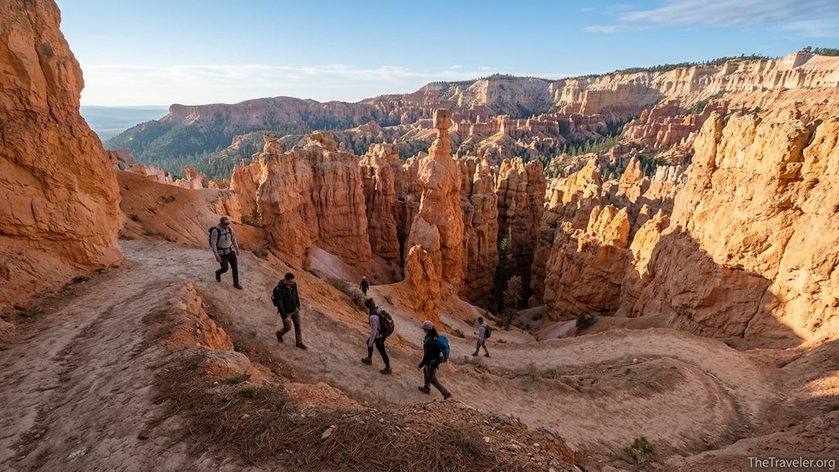
Within just a few minutes of starting your descent, you are looking across at Thor’s Hammer, arguably the most photographed hoodoo in the park. This top-heavy rock pillar stands alone near the rim and is easy to spot from the switchbacks on the Two Bridges side of the loop. Continuing down, you leave the open amphitheater and drop between steep orange walls where tall Douglas firs reach toward a slender slice of sky. For many visitors, this transition from big vistas to intimate canyon is the exact moment they fall in love with Bryce Canyon.
Because the Navajo Loop connects with other classic hikes, such as the Queen’s Garden and Peekaboo Loop, it is also the gateway to longer itineraries. Hikers with more time often combine the Navajo Loop and Queen’s Garden into a 3-mile figure-eight that explores deeper into the hoodoo forest. Others link Navajo with the steeper Peekaboo Loop or even all three to create a half-day “Figure 8” route. Knowing that you can scale your adventure up or down makes Navajo a smart choice, whether you have a single morning or several days to explore the park.
Just as importantly, the Navajo Loop delivers a sense of Bryce Canyon’s human story. Sections of the route trace early trails first cut in the 1910s and later improved by the National Park Service and Civilian Conservation Corps. While you are catching your breath on a switchback, you are literally standing on a century of park history, which adds another layer of meaning to the deep geologic time on display in every rock layer.
Trail Layout, Current Conditions and Seasonal Closures
The Navajo Loop is shaped, as the name suggests, like a loop. From Sunset Point you descend into the Bryce Amphitheater on one of two branches: the Wall Street side or the Two Bridges side. At the bottom the two branches meet at a junction near the sandy canyon floor and a stand of tall pines. From there, you circle back up to Sunset Point on the opposite branch. The loop is signed clearly and, in normal conditions, is straightforward to follow for anyone comfortable on a well-built dirt trail.
However, conditions on the Navajo Loop can change with the seasons. The National Park Service describes it as a moderate trail, but the grade is steep in places, and at roughly 8,000 feet above sea level the thinner air can make the climb feel tougher than the mileage suggests. Spring snow, summer monsoon storms and winter ice can trigger rockfall and mudslides that occasionally damage sections of the trail. In recent seasons, heavy precipitation has periodically closed parts of the route and, at times, shut down the entire loop for repairs.
One important detail is that the Wall Street side typically closes during the coldest months when freeze-thaw conditions and lingering ice make the narrow slot-like section unsafe. In many winters the park keeps the Two Bridges side open so hikers can descend and return as an out-and-back, but after significant storms or slides both sides may be temporarily closed. In early 2026, for example, mudslides affected portions of the loop, prompting a full closure until crews completed repairs. Before you plan a sunrise hike here, check the “Current Conditions” page for Bryce Canyon on the National Park Service website or ask a ranger at the visitor center the day you arrive.
Because the loop connects to Queen’s Garden and the Peekaboo Loop, trail closures can influence your options for longer routes as well. When the Wall Street side is closed, the classic Queen’s Garden–Navajo Loop combination is sometimes rerouted so that hikers descend Queen’s Garden and climb back up on the Two Bridges side or return the way they came. If the entire Navajo Loop is closed, rangers may recommend using Queen’s Garden as the primary access into the amphitheater or suggest alternative hikes such as the Fairyland Loop. It is wise to treat your itinerary as flexible and let current conditions guide your final plan.
Planning Your Visit: Fees, Timing and Getting to Sunset Point
Reaching the Navajo Loop Trail is straightforward. The trailhead sits at Sunset Point, a few minutes’ drive from the Bryce Canyon Visitor Center along the park’s main road. In the busy season, many drivers find the Sunset Point parking lot full by mid-morning, especially between late May and early September. To avoid circling for a space, consider leaving your car in Bryce Canyon City and taking the free park shuttle, which starts operating in early April and runs through much of October. In peak summer the shuttle typically serves Sunset Point every 10 to 15 minutes, and you can hop on at stops like the Shuttle Station outside the park entrance or the visitor center once you have your park admission sorted.
As of early 2026, private vehicles entering Bryce Canyon generally pay a per-vehicle fee valid for seven consecutive days. For many visitors in a car or RV, that is the most economical option. United States citizens and permanent residents can also use an America the Beautiful annual pass, which covers entrance fees at Bryce and hundreds of other federal recreation sites for one year. Non-US residents should be aware of an additional national park surcharge that now applies at Bryce Canyon and several other major parks. For a family of four visiting from abroad, that can significantly increase total entry costs, so it is worth checking exact fees on the park’s official site before you arrive and factoring them into your budget.
When it comes to timing, the Navajo Loop is hikeable in most non-winter months, but the experience changes dramatically with the season and time of day. In summer, temperatures on the rim can be pleasant in the morning and then climb into the 80s Fahrenheit on sunny afternoons. Starting your hike before 9 a.m. not only keeps you cooler but also helps you avoid the densest crowds. In shoulder seasons like May or October, a late-morning start might be more comfortable because overnight lows near freezing can leave shady sections of the trail slick with ice before the sun reaches them.
The direction of travel also matters. Most people begin by hiking down the Wall Street side when it is open or down Two Bridges when Wall Street is closed, then climb back up the opposite side. That pattern delivers the most dramatic first views and allows you to face into the amphitheater as you descend. If your knees are sensitive, you can reverse it and descend the less-steep side or use trekking poles to ease the strain. Because the loop completes back at Sunset Point, it pairs naturally with an early-morning stop at Sunrise Point or an evening return to watch the canyon glow at sunset from the rim.
What the Trail Is Really Like: From Rim Vistas to Slot-Like Switchbacks
Standing at Sunset Point before you begin, you see a sweeping amphitheater packed with thousands of hoodoos. Tour buses and road-trippers line the railings, and it is tempting to take a few photos and call it a day. Yet the Navajo Loop offers something very different from the roadside overlooks. Within minutes of stepping off the paved path, the crowd thins, and the landscape starts to feel three-dimensional. The trail drops away under your feet, and the hoodoos that looked like a textured carpet from above resolve into individual towers and windows.
On the Two Bridges side, the upper switchbacks carve back and forth along open slopes with views across the amphitheater. You can pick out landmarks such as Sunset Point far above and, to the north, the formations near Sunrise Point. Partway down, the trail passes close to Thor’s Hammer, where many hikers pause at a signed viewpoint to photograph the famous pillar with the Bryce Amphitheater spreading out behind it. Expect to share this spot with others, especially late in the morning when day-trippers from Zion National Park arrive, but you can usually find a moment to frame your shot if you are patient.
Continue lower and the canyon walls close in. The soil shifts from light tan to deeper orange, and the air feels cooler and still. If you descend the Wall Street side when it is open, you enter a narrow slot-like section where the trail zigzags sharply between nearly vertical cliffs. A few tall Douglas firs grow improbably from the canyon floor, some of them reaching almost to the rim. Many iconic photographs of Bryce Canyon are taken here, looking up at a sliver of blue sky framed by soaring rock and dark green tree trunks. It is a place where mid-day light can still feel soft because so little direct sun reaches the ground.
At the junction on the canyon floor, a short side path leads toward the Peekaboo Loop and Queen’s Garden, while the main Navajo route curves back toward its climb to the rim. This is a good spot to pause, have a quick snack and listen. Away from the rim traffic, you may hear only the wind and occasional voices echoing between the rock walls. In early summer, puddles and damp sections from recent storms can linger here, so waterproof or at least sturdy hiking shoes are preferable to casual sandals.
Safety, Fitness and Gear: Hiking Smart at 8,000 Feet
Although the Navajo Loop is short, it is not a casual city stroll. The trail loses and then regains about 550 vertical feet, and much of that change happens in concentrated stretches of switchbacks. At roughly 8,000 feet in elevation, your lungs work harder than at sea level. Visitors who are not acclimated to altitude, who are traveling straight from low-lying cities or who are not used to hills can be surprised by how winded they feel on the climb out.
The park has a simple saying at many trailheads: going down is optional, coming back up is mandatory. On the Navajo Loop this is more than a slogan. If you have heart or respiratory conditions, are recovering from illness or are visiting with small children or older relatives, it is worth honestly assessing how far you want to descend. A useful strategy is to walk down just far enough to get a sense of the gradient and then decide whether to continue. Because the loop is relatively short, turning around early does not mean missing everything. Even descending a few switchbacks can dramatically change your perspective on the hoodoos.
Footwear and basic gear matter. The trail surface is mostly firm dirt and rock, with sections that can be dusty and others that can be muddy or slightly icy depending on the season. Low hiking shoes or trail runners with good tread are much safer than smooth-soled sneakers or flip-flops, which are a common sight in the parking lot but a frequent culprit in slips and twisted ankles. Trekking poles can help with both balance and knee strain, particularly on the descent. Even in cool weather, bring at least a liter of water per person and a light snack. In midsummer, two liters per person is more realistic, especially if you plan to extend your hike onto Queen’s Garden or Peekaboo.
Sun and weather exposure also deserve respect. The rim at Sunset Point is wide open, and parts of the trail receive strong sunlight for much of the day. A wide-brimmed hat, sunglasses and broad-spectrum sunscreen can make the difference between an enjoyable half-day and a painful evening. Afternoon thunderstorms are common in the July–August monsoon season. If you see dark clouds building or hear thunder, start heading for the rim rather than committing to additional miles in the amphitheater. The same steep walls that make Wall Street so impressive can funnel water and debris during intense storms, and the park sometimes closes sections quickly when lightning risk is high.
Connecting Trails and Ways to See Even More Iconic Scenery
While the Navajo Loop alone is spectacular, many visitors use it as the backbone of a slightly longer outing that takes in additional viewpoints and quieter corners of the amphitheater. The most popular extension is the combination of Queen’s Garden and Navajo Loop, often hiked clockwise by descending from Sunrise Point, winding among bizarre hoodoo shapes in the “Queen’s Garden,” then climbing back to the rim on the Navajo side to finish at Sunset Point. In total this route is roughly 3 miles and takes most reasonably fit travelers 2 to 3 hours, allowing plenty of time for photographs and breaks.
Another option for strong hikers is to link Navajo with the Peekaboo Loop, a more strenuous circuit that climbs and drops repeatedly as it weaves between isolated hoodoo clusters. Combined with Navajo, this so-called Figure 8 route can total 6 to 7 miles with significant elevation gain, turning your Bryce Amphitheater visit into a solid half-day hike. Because Peekaboo has long stretches without shade and minimal water access, it is best tackled in cooler months or early and late in the day in summer. You will need everything you would bring for Navajo, plus extra water, high-energy snacks and a realistic sense of your fitness.
Even if you choose to stick to the classic Navajo Loop, you can enhance the experience by pairing your hike with rim viewpoints. For example, you might park at the visitor center, ride the shuttle to Sunrise Point for an early look at the amphitheater in soft morning light, then walk the easy rim path to Sunset Point to start the loop. After your hike, you can continue along the rim toward Inspiration Point or Bryce Point for broader panoramas that place the path you just walked into context. This sort of layered itinerary gives you both intimate and wide-angle views of the same landscape.
For travelers arriving from nearby parks such as Zion or Capitol Reef, it is also common to fold the Navajo Loop into a larger road trip. Many people leave Springdale near Zion early, reach Bryce Canyon by mid-morning, hike the Queen’s Garden–Navajo combination, then continue to overnight in accommodations around Bryce Canyon City or head toward small towns like Escalante or Panguitch. Building your day around the Navajo Loop ensures that even a quick stop at Bryce includes quality time below the rim rather than just a snapshot from an overlook.
The Takeaway
The Navajo Loop Trail offers one of the most concentrated doses of scenery in the American Southwest. In a mile and a bit of hiking you move from sweeping amphitheater views to intimate canyon walls, from iconic formations like Thor’s Hammer to the shaded depths of Wall Street. It is short enough to fit into a half-day visit yet rich enough in views and variety to satisfy seasoned hikers, photographers and first-time park visitors alike.
Hiking it well means respecting its challenges. The elevation, the steep switchbacks and the changeable conditions demand sensible planning: good footwear, adequate water, a realistic sense of your fitness and close attention to current closures and weather. It also means arriving early when possible, using the shuttle to avoid parking stress in high season and allowing yourself enough time to pause, look and feel the space rather than racing the clock.
Most of all, treat the Navajo Loop as more than a checklist item. Walk slowly through Wall Street and notice the tree roots gripping the rock. Pause at the canyon floor junction and look back at the path you followed from the rim. Stand at Sunset Point after your climb and trace the curves of the trail below. Approached with preparation and a bit of humility, this modest loop becomes less a casual stroll and more a compact journey through Bryce Canyon’s most iconic landscapes.
FAQ
Q1. How long does it take to hike the Navajo Loop Trail?
Most visitors complete the Navajo Loop in 1 to 2 hours, depending on fitness, how often they stop for photos and whether they add side trips like Queen’s Garden.
Q2. Is the Navajo Loop Trail suitable for beginners or children?
The trail is short but steep, with many switchbacks and high elevation. Fit beginners and older children usually do well if they take frequent breaks, but families with very young kids or mobility issues may prefer to walk only partway down and return the same way.
Q3. Which direction should I hike the loop?
When conditions allow, many hikers prefer to descend the Wall Street side for the dramatic slot-like section and then climb out via Two Bridges. If Wall Street is closed, you will use Two Bridges for both descent and ascent, often as a partial out-and-back.
Q4. Do I need special permits to hike the Navajo Loop?
No special hiking permit is required for the Navajo Loop itself. You only need a valid park entrance pass. Backcountry permits are only necessary for overnight trips on longer remote trails, not for amphitheater day hikes.
Q5. What is the best time of day to hike the Navajo Loop?
Early morning is ideal in most seasons because temperatures are cooler, light is softer for photography and the trail is less crowded. In cooler months, late morning can be pleasant once any overnight ice begins to melt.
Q6. Is the trail open year-round?
Access varies. The Two Bridges side is often open throughout the year, but the Wall Street side usually closes in winter due to ice and rockfall risk. After major storms, the entire loop can close temporarily for safety and repairs, so always check current conditions.
Q7. What should I wear and bring for the hike?
Wear sturdy hiking shoes or trail runners with good tread, layered clothing for changing temperatures, a hat and sunscreen. Carry at least one liter of water per person in cool weather, more in summer, plus a light snack and optional trekking poles.
Q8. Can I do the Navajo Loop and Queen’s Garden in a single outing?
Yes. The popular Queen’s Garden–Navajo combination is about 3 miles and typically takes 2 to 3 hours. Many hikers descend from Sunrise Point via Queen’s Garden and climb back to the rim on the Navajo side to finish at Sunset Point.
Q9. Are dogs allowed on the Navajo Loop Trail?
No. Pets are generally not allowed on most unpaved trails in Bryce Canyon, including the Navajo Loop. They are limited to paved viewpoints, campgrounds and a few short paved paths, and must be leashed where allowed.
Q10. How crowded is the Navajo Loop, and how can I avoid the busiest times?
In peak season the Navajo Loop is very popular, especially from late morning to mid-afternoon. To avoid crowds, start your hike before 9 a.m., consider visiting in shoulder seasons like May or October and use the shuttle so you are not delayed hunting for parking at Sunset Point.