
More news on this day
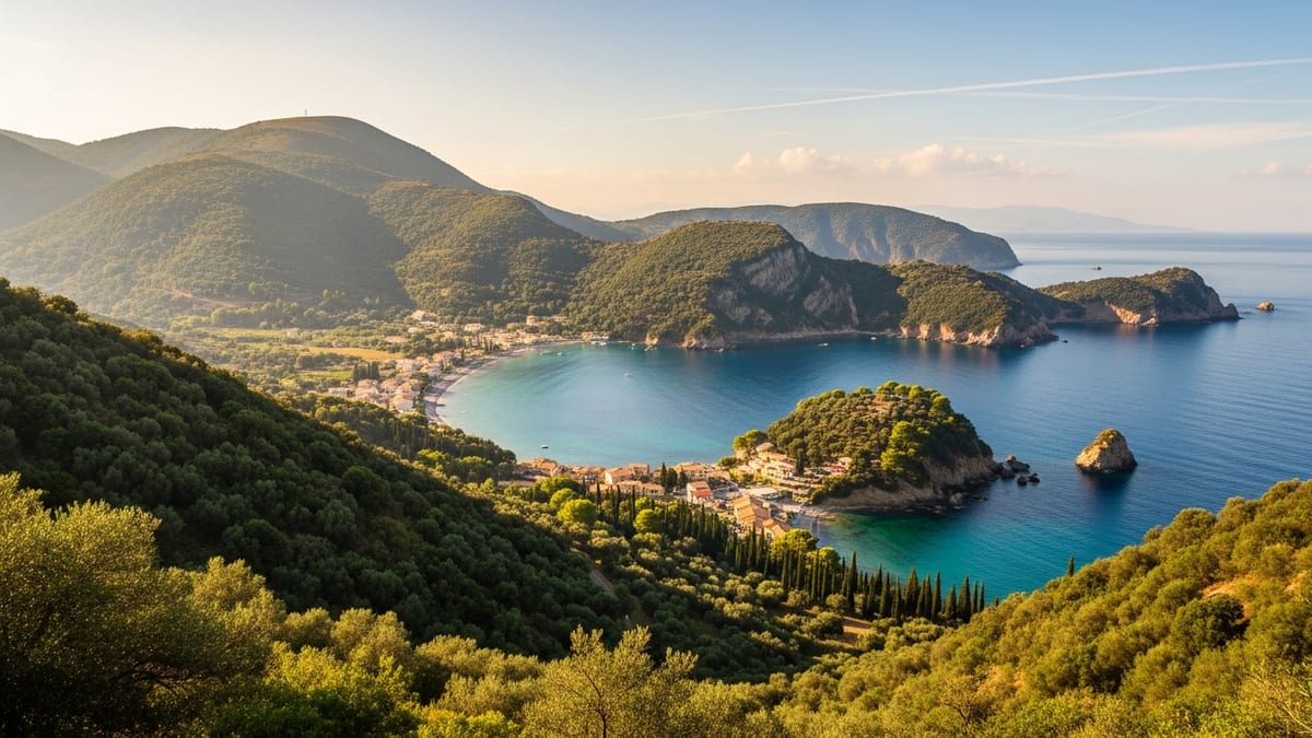
On a coastline better known for Atlantic swells and bracing dips, the tiny fishing village of Portloe on Cornwall’s Roseland Peninsula is emerging as an unlikely warm-water star, with recent analyses suggesting its surrounding inlets now record some of the highest average sea temperatures anywhere in the United Kingdom.
Get the latest news straight to your inbox!
Portloe’s Growing Reputation for Warm Seas
Portloe has long been celebrated locally as the “gem of the Roseland,” a compact harbour village framed by steep, slatey cliffs and traditional whitewashed cottages. Publicly available tourism guides describe it as one of Cornwall’s most protected and unspoilt fishing villages, attracting visitors seeking scenery, walking routes and a quieter alternative to the region’s headline resorts.
In the past year, Portloe has gained unexpected national attention for another reason. According to recent coverage that collates long term monitoring of inshore waters, the sea off Portloe now averages a maximum of around 15.9 degrees Celsius across the year, positioning it as the warmest recorded sea area in the UK. That figure sits above widely cited averages for many other British coastal locations, which typically range between 12 and 15 degrees depending on exposure and season.
Climate and oceanographic data for south west England suggest the trend is part of a wider pattern. The Met Office and marine research organisations report that seas surrounding the south of the UK, including the Celtic Sea and English Channel, have registered persistent temperature anomalies in recent summers, with some areas off Cornwall running several degrees above long term norms. Marine charities based in the county have also highlighted record breaking sea temperatures around Cornwall in the last two years, describing the shift as a critical moment for local marine ecosystems.
For travellers, the emerging data underscores what many wild swimmers and paddlers already suspected. Compared with more exposed Atlantic beaches, sheltered south coast coves such as Portloe often feel notably milder in late summer and early autumn, when water retains heat amassed over the season and prevailing south westerly winds are tempered by the headlands and inlets of the Roseland Peninsula.
Why Cornwall’s South Coast Waters Run Warmer
Geography plays a central role in Cornwall’s reputation for relatively warm seas. Official climate summaries indicate that the sea areas bordering Cornwall record some of the highest annual mean temperatures near the UK, typically in the 11 to 12 degree range. The county’s position at the south western tip of Britain, projecting into the Atlantic and influenced by the Gulf Stream and its offshoot currents, helps moderate winter cold and keep sea temperatures comparatively elevated.
Within Cornwall, the contrast between north and south coasts is marked. The north coast faces the full force of Atlantic swells and open ocean weather systems, which can create dramatic surf but also encourage faster cooling of surface waters. In contrast, the south coast along the English Channel is more sheltered, with indented estuaries, rias and coves that trap heat and are less exposed to prolonged northerly or westerly winds. Roseland’s deep, steep sided inlets, including Portloe’s narrow harbour, are typical of this microclimate.
Seasonality is another factor for visitors planning a swim. Specialist sea temperature trackers focused on Cornwall broadly agree that August and early September are the warmest months for sea swimming, with typical inshore temperatures reaching the mid teens in degrees Celsius. South facing, sheltered beaches on the Channel side can feel slightly warmer at the shoreline, particularly on still days when solar heating of the upper water column is strongest and wind chill at the surface is minimal.
Recent reports of marine heatwaves in the region show how quickly conditions can shift. Analyses released over the last two summers have identified moderate to strong marine heatwave events in seas to the south of the UK, with average temperatures across the Northwest European shelf reaching near record levels for the time of year. While that raises serious concerns for marine life, it also means that, at least in the short term, late summer dips off south Cornwall may feel closer to continental European conditions than many British holidaymakers expect.
Hidden Coves and Family Beaches Near Portloe
Portloe itself is a working harbour rather than a broad bathing beach, but it sits at the centre of a cluster of coves and sandy stretches that benefit from the same relatively warm waters. Shoreline planning documents and local visitor guides highlight several beaches within a short drive or a coastal path walk that combine shelter with good swimming and paddling conditions.
To the east of the village, Portholland offers a modest arc of sand backed by traditional cottages, with rock pools exposed at low tide. Its south east facing aspect helps catch the sun and provides some protection from prevailing winds. Further around the headland, Kiberick Cove remains largely undeveloped, a steep sided shingle and sand inlet reached via the South West Coast Path and known among experienced walkers and more adventurous swimmers for its seclusion.
To the west, Carne and Pendower form one of the Roseland’s standout south facing beach complexes. These adjoining sands curve gently along Gerrans Bay, offering long, shallow slopes into the water that suit family paddling and beginner bodyboarding when conditions are calm. Information from local tourism bodies notes that the beaches are backed by low cliffs, fields and minimal commercial development, maintaining a natural feel even at busy times of year.
Between these better known stretches, the coastline is punctuated with small, unnamed coves and rocky ledges accessible from the coast path, many with patches of sand at low water. Their orientation means that, on the right tide and in settled weather, swimmers can find pockets of relatively warm, glassy water only a few steps from exposed headlands where the sea state feels entirely different.
Planning a Warm Water Break on the Roseland Peninsula
The character of the Roseland Peninsula makes Portloe a practical base for travellers intent on finding some of Cornwall’s warmest accessible seas. The area sits within a designated Area of Outstanding Natural Beauty, and the South West Coast Path runs directly through the village, giving car free access to many coves for those prepared for steep ascents and descents. Public information produced by local councils describes Portloe as compact and largely unchanged in layout for more than a century, with narrow lanes and limited parking that help cap visitor numbers.
Timing plays an important role in how warm the water feels. Families and casual swimmers looking for milder conditions are likely to gravitate towards late July through September, when sea temperature trackers for Cornwall consistently show the highest readings and air temperatures on the south coast typically sit around the high teens or low twenties in degrees Celsius. Shoulder months in spring and late autumn can still offer strikingly clear days and calm seas, but wetsuits become advisable for anything more than short dips.
Prospective visitors are increasingly consulting real time sea temperature dashboards, local harbour webcams and independent swimming communities to fine tune their plans. These channels, together with official forecasts, provide up to date indications of sea state, recent rainfall and any potential water quality advisories that may follow heavy weather. The same sources can highlight when marine heatwave conditions are elevating temperatures beyond the seasonal norm along the south Cornish coast.
For those willing to explore beyond Portloe itself, other south coast spots such as Portmellon, Porthpean and the sheltered stretches of the Fal and Helford estuaries provide further options within day trip range. While each has its own character and level of development, they share a broadly similar climatic profile, benefitting from the same relatively warm sea area and the protective topography of Cornwall’s southern shore.
Balancing Beach Tourism With a Changing Sea
The spotlight on Portloe’s comparatively warm waters comes as local conservation groups warn about the ecological implications of rising sea temperatures around Cornwall. Cornwall based wildlife organisations report that record warmth and repeated marine heatwave episodes are altering conditions for kelp forests, shellfish beds and seabird feeding grounds, with potential knock on effects across the food web.
Researchers note that while visitors may welcome more comfortable swimming conditions, higher baseline temperatures can stress cold adapted species and encourage the spread of warm water organisms, including some invasive species and pathogens. Combined with pressures from coastal development and intermittent pollution incidents, these shifts add complexity to how Cornwall manages its much photographed shoreline.
Tourism bodies in the region increasingly frame warm water draws such as Portloe and its neighbouring beaches within broader messages about responsible travel. Public facing materials encourage visitors to stick to established paths on fragile cliff tops, respect seasonal wildlife restrictions and check local guidance on bathing water quality during and after storm events. There is also growing emphasis on supporting small, locally owned businesses that are closely tied to the long term health of the coast.
For now, Portloe’s status as a hidden gem with some of the UK’s warmest seas is likely to strengthen its appeal to swimmers and beachgoers seeking quieter corners of Cornwall. How that appeal is balanced with the realities of a rapidly warming ocean will be a recurring theme for communities along the Roseland Peninsula and beyond in the seasons ahead.