
More news on this day
Operations at Detroit Metropolitan Wayne County Airport faced major disruption as a fast-moving line of severe thunderstorms triggered a temporary ground stop, halting many departures and rippling delays across the national air network.
Get the latest news straight to your inbox!
Storms Sweep Through Metro Detroit
Publicly available weather radar and forecast discussions show strong to severe thunderstorms tracking across southeast Michigan, coinciding with the busiest afternoon travel window at Detroit Metro Airport. The storms developed in hot, humid air over the region, with forecasters noting an unstable atmosphere favorable for damaging wind gusts and heavy downpours.
Coverage from local meteorological outlets in Detroit indicates that forecasters had been warning of a heightened storm risk, including the potential for severe weather, as heat and humidity built through the early part of the week. As the storms arrived, lightning, torrential rain and rapidly shifting winds reduced visibility and created unsafe conditions for ramp operations.
The broader pattern fits into a multi day severe weather setup affecting large portions of the central and eastern United States. National forecast centers describe a corridor of repeated thunderstorm development stretching from the Plains into the Great Lakes, increasing the likelihood of disruptive weather at major hubs such as Detroit.
Ground Stop Order Freezes Departures
Real time air traffic management data from the Federal Aviation Administration’s National Airspace System status page indicated a ground stop affecting flights bound for Detroit, meaning some departures from other airports were temporarily held at their origin. Such orders are typically issued when storms or low visibility sharply reduce the arrival rate that an airport can safely handle.
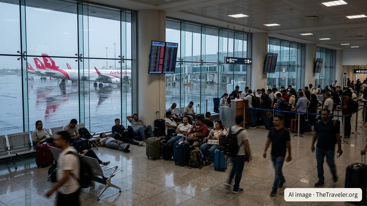
During the ground stop period, aircraft on the ground at Detroit Metro faced delays leaving gates or taxiing for departure while lightning and wind remained in the area. Ramp personnel cannot safely work near aircraft during frequent lightning strikes, which pauses fueling, baggage loading and pushback operations even for flights not directly affected by low clouds or visibility.
Once the worst of the storms moved through, the formal stop order was lifted and replaced with a ground delay program, according to operational summaries shared by national aviation tracking sites. Under a delay program, flights may continue to operate, but at a reduced rate, leading to longer than normal waits for takeoff and landing slots.
Passengers Confront Cascading Delays
Travelers passing through Detroit reported significant waits as departure boards filled with delays and scattered cancellations. Social media posts from passengers described crowded gate areas, extended time on parked aircraft and uncertainty about missed connections as the weather system moved through.
Because Detroit Metro serves as a major connecting hub, disruption there can quickly spread through an airline’s broader network. When arriving aircraft are diverted or heavily delayed, subsequent departures often lack available planes or crews, even after the weather itself has improved. Airline status tools and flight tracking sites on Tuesday afternoon showed knock on delays on routes well beyond Michigan, illustrating how a single ground stop can ripple nationwide.
Public guidance from airport and airline travel tips emphasizes the importance of checking flight status frequently during volatile summer weather patterns. Many carriers encourage passengers to use mobile apps for rebooking and to monitor aircraft routing, which can provide early indications of likely delays if an incoming flight becomes stuck behind storms elsewhere.
Safety Rules Drive Operational Decisions
Industry safety protocols require that operations pause when lightning is detected close to the airfield or when wind gusts, hail or intense rainfall create hazards around parked aircraft. Ground crews working beneath large metal equipment and fueling systems face particular risk, and ramp closures are a standard precaution until storm cells pass.
Aviation experts who comment in publicly accessible training and safety materials note that these brief but intense shutdowns are designed to prevent injuries and equipment damage, and are now a routine part of peak season operations across much of the United States. While frustrating for travelers, the temporary stoppages typically last only as long as the severe storm core remains overhead.
Detroit’s position in the Great Lakes region exposes the airport to rapidly changing conditions, from winter snow bands to warm season thunderstorms. Historical climate and operations data compiled for the airport show that convective storms are a recurring driver of summer delay spikes, especially during late afternoon and evening hours when both passenger demand and storm potential tend to peak.
What Travelers Can Expect Next
Short range forecasts for southeast Michigan indicate that the pattern of hot, humid air and periodic disturbances may persist, keeping the risk of additional thunderstorms in place over the coming days. Outlooks from national forecast centers point to a continued chance of strong storms across parts of the Midwest and Great Lakes, suggesting that further weather related travel disruptions are possible.
Airlines typically respond to such patterns by issuing weather waivers on select routes, allowing passengers to adjust travel plans without standard change fees. According to publicly posted customer advisories from major carriers, these waivers are often extended or expanded as confidence in a prolonged storm threat increases.
For those scheduled to fly through Detroit Metro, travel planners recommend building extra time into itineraries, favoring morning departures when feasible and monitoring both airport conditions and broader regional radar trends. While the ground stop at Detroit was temporary, the broader severe weather regime influencing the central United States means that flight operations may remain sensitive to sudden storm development for several days.