
More news on this day
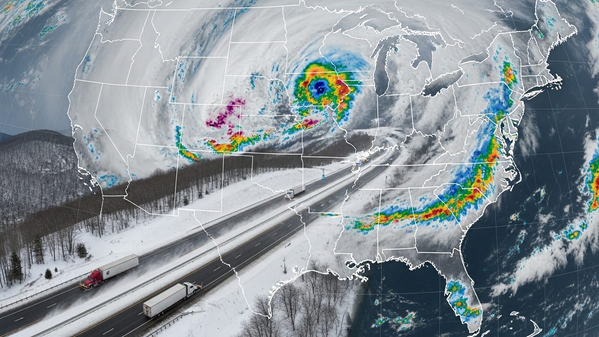
Texas has joined a growing swath of the country facing flash floods, tornado risks, dangerous heat and severe thunderstorms, as volatile early summer weather disrupts travel and triggers advisories from the Southern Plains to the Mid-Atlantic.
Get the latest news straight to your inbox!
Multi-Hazard Pattern Expands From Gulf Coast to Mid-Atlantic
Publicly available forecasts from federal and private weather services indicate that a sprawling storm pattern is now affecting at least eleven states, including Texas, Arkansas, Oklahoma, Louisiana, Kansas, Nebraska, Colorado, Wyoming, Virginia, Florida and Pennsylvania. The setup combines deep Gulf moisture, lingering tropical energy and strong upper-level winds, creating repeated rounds of intense thunderstorms over the same corridors.
Recent outlooks show that Texas has become a focal point as heavy rain bands linked to a recent Gulf system sweep inland, adding to weeks of severe weather episodes. Reports describe flash flood warnings around major metro areas and along key highway corridors, while portions of eastern Texas and neighboring Louisiana have seen several inches of rain in short periods, overwhelming drainage and smaller rivers.
Farther north, severe thunderstorm watches and warnings have extended across the central High Plains into Nebraska, eastern Colorado and eastern Wyoming. Weather summaries describe storms capable of large hail, damaging wind gusts and localized flash flooding, with some activity tracking east toward Kansas and western Missouri. At the same time, a separate storm corridor has been impacting Virginia and Pennsylvania, where humid, unstable air ahead of frontal boundaries has fueled late-day thunderstorms.
In Florida, the same moist tropical air feeding heavy rain along the Gulf Coast has contributed to repeated downpours and thunderstorms over interior and coastal zones. Aviation and highway reports from the state describe periods of reduced visibility, ponding on roadways and intermittent delays at major airports when storms pass directly over departure and arrival paths.
Flash Flooding and Saturated Ground Heighten Travel Risks
Hydrologic outlooks and radar-based rainfall estimates show that saturated ground is emerging as a central concern from Texas through the lower Mississippi Valley and into portions of the Mid-Atlantic. In parts of southern and eastern Texas, recent analysis indicates pockets of more than 6 inches of rain within a few days, especially near the coast and along major river basins. Similar multi-inch totals have been noted in segments of Louisiana and Mississippi as storm bands repeatedly train over the same areas.
In Arkansas and Oklahoma, a spring of frequent severe weather has left soils primed for rapid runoff. Even moderate additional rainfall is now more likely to trigger urban flash flooding and swift rises on creeks and small rivers. Travelers on interstate routes crossing these states are encountering temporary lane closures where water covers low-lying segments, as transportation agencies emphasize that flooded pavement may conceal washouts or debris.
Kansas and Nebraska have faced a combination of heavy rain and strong thunderstorms tied to frontal boundaries drifting across the Plains. With rain-cooled air undercut by fresh surges of moisture, localized flooding is occurring near drainage ditches, underpasses and rural low-water crossings. Some smaller highways in farm country have become difficult to traverse as standing water and mud collect along unpaved shoulders.
In Virginia and Pennsylvania, recent severe weather briefings highlight a corridor of heavy rain where thunderstorms move slowly along a stalled front. Short, intense cloudbursts have produced street flooding in urban corridors and near major river towns, complicating both commuter traffic and long-distance travel. Rail operators have reported the need for speed restrictions when water pools on tracks or when strong storms bring down limbs and debris along rights of way.
Tornado and Severe Storm Threats Span the Central U.S.
Convective outlooks from national storm prediction services show that the central United States remains under periodic risk for tornadoes and widespread severe thunderstorms. In recent weeks, Kansas, Nebraska, Oklahoma and parts of Texas have seen repeated days with elevated tornado probabilities, with some events also extending into Arkansas, Louisiana and portions of Colorado and Wyoming.
Storm reports compiled for early June list dozens of severe weather incidents in Texas alone on a single day, including damaging wind gusts, large hail and a handful of confirmed tornadoes across multiple counties. Similar logs identify severe wind and hail episodes in the Dakotas, Wyoming and Florida, underscoring how far-reaching the current pattern has become. While many tornadoes have been relatively brief or confined to rural areas, rotating supercell storms crossing major highways have caused sudden whiteout conditions in rain, hail-covered pavement and scattered debris.
Across the High Plains, severe thunderstorm watches have been posted from eastern Colorado and eastern Wyoming into the Nebraska panhandle and western Kansas. Forecast discussions indicate that these storms can quickly transition from high-based lightning producers to more dangerous systems with strong downbursts and hail once they tap richer low-level moisture. Drivers crossing open stretches of Interstate 70, Interstate 80 and feeder routes are being urged through public messaging to monitor radio and mobile alerts, as storm intensity can change rapidly along the route.
In the Southeast and Gulf Coast region, the remnants of a recent tropical system, which achieved named-storm status over the Gulf of Mexico, have fueled pockets of severe weather from coastal Texas through Louisiana and into parts of Florida. Published coverage from national outlets describes tornado warnings in southern Louisiana and strong thunderstorms sweeping inland, adding a rotating-storm component to the broader heavy-rain and flood threat.
Dangerous Heat Compounds Hazards for Travelers
Alongside storms and flooding, dangerous heat is emerging as a parallel concern across several of the affected states. Climate outlooks and short-term temperature forecasts point to heat indices well above seasonal norms in parts of Texas, Oklahoma, Kansas, Louisiana and Florida, particularly during lulls between storm complexes. The combination of high humidity and triple-digit heat index values increases the risk of heat-related illness for those spending extended time outdoors or stranded in stalled vehicles.
In Texas, recent seasonal outlooks for the Rio Grande Valley and surrounding regions highlight the potential for an early onset of significant heat stress, especially where drought persists just inland from the coastal flood zone. When strong sun returns after each storm round, pavement and vehicle interiors can heat rapidly. Travelers stuck in traffic behind crash scenes, flooded underpasses or downed power lines are more exposed to heat than typical, particularly if engines are off and air conditioning is unavailable.
Farther north, states such as Nebraska and Kansas are also experiencing bouts of heat on the edges of the storm corridor. Forecast discussions note that areas south and west of frontal boundaries can see temperatures spike even as nearby regions contend with clouds and thunderstorms. This sharp gradient means that motorists can move from heavy rain and standing water into hot, stagnant air within a relatively short drive, making hydration and rest stops more important for long-haul truckers and vacation travelers alike.
In Florida and parts of the Southeast, heat and humidity are combining with frequent thunderstorms to create what forecasters describe as oppressive conditions. Even when showers bring temporary relief, dew points remain high, and outdoor workers along highways and in airports must manage both lightning safety delays and heat exposure as they support elevated summer travel volumes.
What Travelers Across the Affected States Should Expect
Transportation agencies, airport operators and travel services are signaling a period of elevated disruption risk as this multi-hazard pattern continues. In Texas and neighboring Gulf states, motorists can expect rapidly changing conditions, with roadways that are dry one hour becoming impassable the next due to flash flooding or downed trees. Detours onto secondary roads may lead travelers into areas with poorer drainage and weaker cellular coverage, complicating navigation when storms intensify.
In the central Plains and High Plains, including Kansas, Nebraska, Colorado and Wyoming, cross-country travelers are likely to encounter severe thunderstorm lines, quick visibility drops in heavy rain and strong crosswinds, especially for high-profile vehicles. Publicly available airline data show that convective storms have already led to ground stops, diversions and cascading delays at some hub airports when lightning and hail approach the field, with ripple effects extending to connecting flights across the country.
For the Mid-Atlantic and Northeast gateways serving Virginia and Pennsylvania, the main weather-related impacts involve late-day thunderstorm clusters that form near commuter peaks. These storms can trigger short-notice delays on both road and rail corridors, especially when intense rainfall coincides with heavy traffic volumes. On the East Coast and in Florida, travelers should anticipate periodic halts to airport ramp operations due to lightning, along with delays at cruise and ferry terminals when strong storms move through harbor areas.
Forecast centers indicate that this unsettled pattern is likely to persist in the near term, with additional waves of storms and heat expected as summer progresses. Travelers planning routes through any of the affected eleven states are being encouraged through public advisories to build extra time into itineraries, check forecast updates frequently and remain prepared for abrupt changes in conditions, from flash flooding and tornado warnings to dangerous heat on seemingly calm days.