
More news on this day
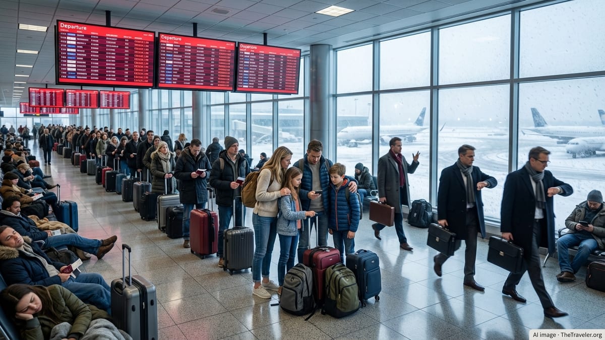
Thunderstorms sweeping across the Mid Atlantic on Sunday evening triggered a ground stop at Baltimore/Washington International Thurgood Marshall Airport, stranding passengers in terminals and setting off hours of rolling delays that spilled into Monday morning schedules.
Get the latest news straight to your inbox!
Ground Stop Freezes Departures At Peak Travel Time
Publicly available Federal Aviation Administration advisories and local media reports indicate that a temporary ground stop was issued for Baltimore/Washington International Thurgood Marshall Airport on Sunday evening as storms moved through the Washington and Baltimore region. The halt came during a busy period for late-afternoon and evening departures, forcing airlines to pause takeoffs as lightning, low clouds, and strong winds affected the airfield.
Operational summaries show that the ground stop began around the dinner hour, with the FAA listing thunderstorms as the primary impact near BWI and across the broader capital region airspace. The measure, designed to keep aircraft from departing toward an affected airport, quickly led to gate holds, extended boarding times, and aircraft waiting on the ramp for clearance.
Tracking data and airline status pages reflected departure delays that stretched well beyond the window of the most intense storms. Once the ground stop was lifted, crews had to reposition aircraft and realign flight sequences, leaving some evening departures pushed back by several hours and contributing to missed connections downline.
Social media posts from travelers described crowded concourses, rapidly changing departure times, and long lines at customer service counters as airlines worked through the backlog. Some passengers reported being advised to rebook for first-morning departures, effectively turning a weather event into an unplanned overnight stay at or near the airport.
Severe Storms Sweep Across Mid Atlantic Airspace
The BWI disruptions formed part of a broader severe weather pattern that affected much of the Mid Atlantic over the weekend. Forecast discussions from the National Weather Service and regional coverage from outlets in Washington and Baltimore described a hot, humid air mass giving way to a strong cold front, sparking scattered but intense thunderstorms Sunday afternoon and evening.
These storms produced damaging wind gusts, heavy downpours, frequent lightning, and pockets of small hail across parts of Maryland and northern Virginia. Observations compiled by meteorologists in the region noted wind speeds in some cells reaching the threshold for severe thunderstorm criteria, with reduced visibility and turbulent conditions that are particularly disruptive to takeoffs and landings.
National overview data show that the weekend’s thunderstorms fitted into a notably active early-summer pattern, with thousands of storm reports logged across dozens of states over the past week. In the Mid Atlantic, the strongest activity was concentrated in a several-hour window on Sunday, roughly coinciding with the period when BWI saw its most significant operational constraints.
While the severe thunderstorm watch for the Washington region was allowed to expire by late evening, residual showers and lingering lightning risk kept operations cautious into the night. That, in turn, limited how quickly airlines could clear the queue of delayed departures from BWI and surrounding airports.
Cascading Delays Ripple Through Airline Networks
The immediate effect of the BWI ground stop was felt locally, but its impact spread through airline networks across the United States. When an airport is subject to a full or partial halt on departures and arrivals, aircraft and crews fall out of their planned rotations, leading to knock-on delays and schedule changes for flights many time zones away.
Airline operations centers rely on complex scheduling to ensure that airplanes, pilots, and cabin crews converge at the right place and time. A multi-hour disruption at a hub or focus city like BWI can leave aircraft overnighting in unintended locations and crews timing out under duty rules, forcing carriers to cancel or combine flights to rebalance their fleets the following day.
Reports from airline-focused tracking services and traveler forums on Sunday and Monday indicated that late-evening BWI delays fed into Monday morning schedules at several destination airports. Some early flights departed without all connecting passengers, while others were retimed to allow for incoming crews and equipment arriving from the Mid Atlantic.
Separate coverage of storms in other parts of the country, including ground delays at major airports in Texas and Michigan, suggests that carriers were already operating in a stressed environment before the BWI event. The cumulative effect of multiple regional weather disruptions has been longer average delays and a greater likelihood that a localized thunderstorm outbreak can trigger nationwide scheduling headaches.
Travelers Face Overnight Stays And Limited Options
For passengers at BWI, the timing and duration of the storms translated into a long evening in the terminal. With many flights scheduled near the onset of the ground stop, gate areas filled quickly, and food outlets and charging stations became crowded as travelers waited for updates.
According to accounts shared on social channels and in local coverage, some airlines began proactively offering rebooking options once it became clear that storms and air traffic constraints would outlast crew duty windows. Passengers whose final destinations were within driving distance of Baltimore reported opting to leave the airport by car, while others sought hotel rooms as late-night departure times slipped further.
Industry guidance generally urges travelers to rely on carrier apps and text alerts for the most current status information in such situations. During Sunday’s event, screenshots shared publicly showed departure times repeatedly revised in 15 to 30 minute increments as airlines awaited updated slots from air traffic controllers and confirmed crew availability.
Limited spare capacity on already busy summer schedules meant that same-day alternatives were scarce on some routes. Passengers on the last flights of the night, or those with complex itineraries involving connections through other storm-affected hubs, were among the most likely to face overnight delays or rebooked itineraries stretching into midweek.
Ongoing Storm Season Raises Summer Travel Risks
The disruptions at BWI come as forecasters highlight an unsettled pattern heading into the peak of the summer travel period. National meteorological briefings in recent days have pointed to repeated rounds of thunderstorms across the eastern half of the United States, with the Mid Atlantic, Southeast, and parts of the Midwest all experiencing significant storm days since early June.
Air traffic performance analyses published by the FAA show that convective weather, including thunderstorms and associated wind shear, is among the leading causes of delays during the warm season. When storms align with major air routes and operating hubs, the effect can be magnified, leading to days when a brief period of severe weather accounts for a large share of nationwide delays.
Planning documents released earlier this year indicate that BWI is already preparing for future capacity constraints linked to runway work slated for later in 2026, with expectations of reduced arrival spacing during construction. While those changes are still months away, aviation analysts note that the combination of infrastructure projects and a volatile storm season could leave little margin for error on some of the busiest travel days.
For travelers, Sunday’s experience at BWI serves as another reminder of the vulnerability of summer air travel to fast-evolving weather. Travel experts often recommend booking earlier flights in the day, allowing extra time for connections, and monitoring forecasts along the full route, including any intermediate hubs, to reduce the risk of being stranded when storms sweep through key air corridors.