


Svartifoss is not Iceland’s biggest waterfall, but it is one of its most distinctive. Tucked into the hills above Skaftafell in Vatnajökull National Park, this basalt-column cascade is a classic stop for independent travelers driving Iceland’s Ring Road. This guide focuses on the practical questions that matter on a tight itinerary: where Svartifoss is, how to reach it from Route 1, how long the hike takes, what the trail is really like, and how to combine it with other Skaftafell highlights.
Get the latest updates straight to your inbox!
Where Svartifoss Fits Into Skaftafell and the Ring Road
Svartifoss sits in the Skaftafell area of Vatnajökull National Park in southeast Iceland, roughly midway between Vík and Höfn along Route 1. It is not a roadside waterfall. To see it, you turn off the Ring Road onto a short signed access road for Skaftafell that climbs gently to a developed visitor area with a large parking lot and campground at the foot of the mountains.
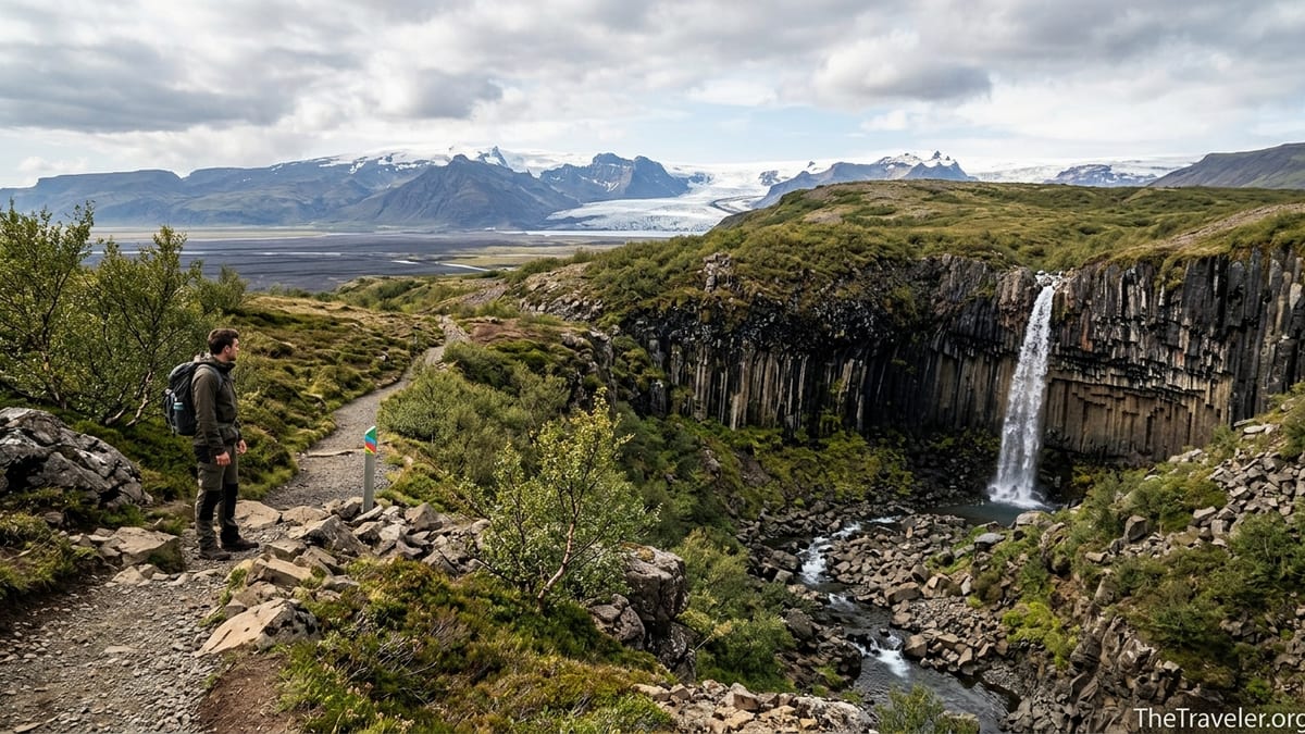
The waterfall itself lies in a small gorge above this hub, reached only on foot. From the Skaftafell visitor centre or adjacent campground you follow marked trails uphill through low birch and heathland to a viewpoint across from the falls. The setting feels surprisingly wild given how close you are to the main highway, with views back toward the black glacial outwash plains and ahead to the ice of Vatnajökull.
For Ring Road drivers, Skaftafell functions as a self-contained base: there is a national park visitor centre, paid parking, toilets and a sizable campground, but no town directly at the site. Services such as fuel, groceries and accommodation clusters are in nearby settlements along Route 1, so advance planning is useful if you are arriving late or leaving early.
Because the access road to Skaftafell is paved and close to sea level, no F-roads or river crossings are involved. In normal summer conditions a standard two-wheel-drive rental car is sufficient. Winter storms can temporarily affect Route 1 itself, so always check road and weather forecasts if you are traveling outside the main season.
What Makes Svartifoss Special
Svartifoss is modest in height compared with Iceland’s giants, but its drama comes from geology rather than volume. The water drops over a semicircular wall of dark basalt columns, many of them sharply hexagonal. These cooling columns inspired both the waterfall’s name, which refers to the black rock, and elements of several Icelandic buildings, including the Hallgrímskirkja church in Reykjavík.
The gorge around the falls is strewn with broken column fragments that resemble organ pipes toppled into the stream bed. The main viewpoint gives a classic frontal view that highlights the contrast between white water and near-black rock, and in soft light the subtle color bands in the basalt stand out beautifully in photographs.
Svartifoss is also part of a chain of waterfalls carved by the same stream. On the main approach path you will usually pass Hundafoss and Magnúsarfoss, each with its own character and vantage points. Many visitors comment that this sequence of falls combined with broad views over the Skeiðarársandur plains makes the hike feel richer than a single out-and-back to one attraction.
Just as important is context. Skaftafell is one of Iceland’s classic hiking areas, with a network of waymarked trails that range from short glacier-view strolls to demanding full-day mountain circuits. Svartifoss is often the first taste of this landscape for Ring Road travelers and can be a stand-alone stop or part of a longer hiking-focused stay.
Who This Hike Suits (And Who It Does Not)
The standard Svartifoss hike is well suited to independent travelers following the Ring Road who want a leg-stretch with clear rewards. It appeals to landscape and nature photographers, geology enthusiasts and anyone building an itinerary around Iceland’s waterfalls. Families with school-age children and adults of average fitness typically find the route achievable, provided they are comfortable with steady uphill walking.
Visitors expecting a drive-up viewpoint should adjust their expectations. Svartifoss is not visible from the road, the car park or the visitor centre area. You must hike to see it, and there is no vehicle access to the gorge. The uphill is not extreme but it is sustained, so people with serious mobility limitations, recent injuries or who struggle with uneven surfaces may find the route challenging.
The path is generally well built, but it includes gravel sections, occasional steps and potentially muddy or icy patches depending on the season. Sturdy footwear with good grip is strongly recommended year-round. In winter and the shoulder seasons, basic traction devices such as microspikes are often advised because packed snow and ice can linger on shaded sections of the trail.
Those on extremely tight schedules should also consider whether they can realistically add Svartifoss. Between parking, visiting the restroom, walking to the falls, enjoying the views and returning, the stop can easily become a half-day break in your Ring Road drive rather than a quick roadside photo stop.
Understanding the Main Svartifoss Routes
Trails in Skaftafell are organized into numbered routes by Vatnajökull National Park, and Svartifoss features prominently in this system. One of the best-known options is the loop route that links Svartifoss, the Sjónarsker viewpoint and the old turf farm at Sel. On park maps this is described under a specific trail code that includes official distance, elevation gain and estimated hiking time.
At the time of writing, those official numbers are the primary reference for planning your day. Before publishing, the writer of this article must pull the current distance and time estimates for the Svartifoss loop from the latest Vatnajökull National Park route description and cross-check them against at least one recent hiking-focused source such as a specialist trail guide. Because trail work, reroutes and grading improvements can change the figures, they should not be guessed or copied from outdated material.
Alongside the full loop, many visitors opt for a shorter out-and-back hike that starts at the Skaftafell visitor centre or campground, follows the main waymarked path past Hundafoss and Magnúsarfoss and then returns the same way from the Svartifoss viewpoint. This option shares the same initial ascent and surface but skips the more undulating upper section, which can save time if your itinerary is packed or the weather is turning.
Waymarking in the area is typically clear, with colored route posts and trail maps displayed near the visitor centre. Underfoot, expect a mix of compacted gravel, occasional wooden steps and short rockier sections. The steepest parts are early in the climb and again near the gorge, but in dry, ice-free conditions most hikers regard the walk as non-technical. Always allow extra time if you are traveling with children, stopping for photography or visiting in winter conditions.
Logistics: Getting to Skaftafell, Parking and the Visitor Centre
From Reykjavík, Skaftafell lies a full day’s drive east on Route 1. Exact times vary with weather, stops and road conditions, but many travelers allow a broad window of four to six hours of pure driving in summer, often longer in winter. From Vík, Skaftafell is typically two to three hours away, while from the Höfn side it is usually reached in a similar time frame. These are approximate planning windows rather than precise timing promises.
Route 1 through this section of the south coast is paved and well maintained, though exposed to strong winds and occasional blowing sand. In summer it is normally passable in standard rental cars without special equipment, while in winter and early spring short-term closures can occur during severe storms or heavy snowfall. No F-roads are involved in reaching Skaftafell, so a 4x4 is not required solely for this visit.
Skaftafell operates a paid parking system that covers the main visitor centre lot and additional bays near the campground. The regional parking fee is charged per vehicle, not per person, and is valid until midnight on the day of purchase. Recent information checked against national park sources and local operators indicates that a passenger car fee currently starts in roughly the low four-figure range in Icelandic krónur, with larger vehicles higher. Exact prices change periodically, so you should always confirm the latest fee on arrival or in official park information before your trip.
Payment is typically made at machines in the parking area or through a mobile parking app that is widely used at Icelandic natural sites. Signs in the lot explain which app and code apply at Skaftafell and note any seasonal reservation requirements. In recent high seasons, a separate parking service fee with reservable time slots has been trialed on peak summer days for arrivals within certain daytime hours. Because the details can change from year to year, travelers should read on-site signage carefully and check for updates when planning a summer visit.
The Role of the Skaftafell Visitor Centre
The Skaftafell visitor centre, also called Skaftafellsstofa, serves as the main information hub for the southern territory of Vatnajökull National Park. It is open year-round with varying seasonal hours and provides up-to-date advice on trails, conditions and safety. Rangers and staff can explain current recommendations for Svartifoss, Skaftafellsjökull viewpoints and longer routes into the mountains.
Inside, you will find detailed hiking maps, displays on local geology, glaciers and wildlife, and information about the history of farming and settlement in Skaftafell. Staff can clarify which routes are suitable for your group’s abilities, how much time to allow, and whether snow, ice, mud or flooding is affecting any part of the network. They can also point out temporary trail closures or reroutes that may not yet appear on printed materials.
Practical services at or near the visitor centre include toilets, a small shop or kiosk in season and access to the large campground, which stretches across the grassy area below the hills. For road-trippers, this campground can be an ideal overnight base, turning the Svartifoss hike into a relaxed morning or evening outing rather than a rushed midday stop.
Because opening hours and specific services sometimes change for operational reasons, it is sensible to check current information shortly before your visit. National park announcements and regional tourism sites typically post any significant updates on hours, construction or access restrictions affecting Skaftafell.
Best Time to Visit Svartifoss
Summer is the most popular time to hike to Svartifoss. From roughly late May through August, daylight is long, trails are usually free of snow and ice, and temperatures are relatively mild by Icelandic standards. The trade-off is that parking lots and viewpoints can feel busy, especially in the middle of the day, and the ground may be soft after rain due to high visitor traffic.
The shoulder seasons of late spring and early autumn can offer a quieter experience with slightly shorter days and more variable weather. During these periods, patches of snow or ice may still linger on shaded sections of the Svartifoss trail, particularly in early spring or after cold snaps, while wetter spells can make sections muddy. Waterproof footwear and a warm, windproof outer layer become especially important.
Winter transforms the hike into a more serious outing. Days are short, and the trail can be snow-covered or icy for long stretches. National and local hiking resources often recommend carrying microspikes or similar traction for Skaftafell’s popular routes in these conditions, along with trekking poles if you are used to using them. While the sight of Svartifoss framed by snow and icicles is striking, adverse weather and limited daylight may make it impractical or unsafe to attempt on a packed schedule.
In all seasons, access is subject to change. Sections of the Svartifoss route can be closed or partially restricted because of ice, risk of rockfall, saturated ground or maintenance work. No guide should promise that the trail is always open. Instead, travelers should plan to check park alerts and on-the-day advice from Skaftafell visitor centre staff before setting out.
Safety Essentials for the Svartifoss Hike
Weather in the Skaftafell area is strongly influenced by both the Atlantic and the nearby ice cap, and it can change quickly even on apparently calm days. Always check the latest regional forecast before leaving the Ring Road, and be prepared to adjust your plan if strong winds, heavy rain or poor visibility are expected. Cloud ceilings can drop rapidly over the hills, making higher sections of the network feel more remote.
Clothing choices are critical for comfort and safety. A common approach is to dress in layers: a moisture-wicking base, a warm midlayer and a waterproof, windproof outer shell. Even in summer, temperatures can feel cool in the breeze or near the spray of the waterfall, and sudden showers are normal. Gloves and a hat are worth carrying much of the year, particularly if you are prone to feeling cold.
Footwear should provide good grip and support. Lightweight hiking shoes or boots with a firm sole are preferable to smooth-soled trainers, especially if you will be walking on wet rock, mud or early-season snow. In winter and the shoulder seasons, consider microspikes or similar traction to reduce the risk of slips. The trail surface is not technical, but a twisted ankle far from the car park can still disrupt your trip.
At the waterfall itself, respect barriers and viewing platforms. Fences and ropes are there to keep visitors clear of unstable ground and to protect fragile vegetation along the gorge. Rocks near the water can be very slippery, and sudden surges or falling ice are possible in colder months. For overall safety information, consult national and regional advisories and follow any instructions from park rangers, who have the most current picture of trail conditions.
Combining Svartifoss With Other Skaftafell Highlights
Even if you are focused primarily on Svartifoss, it is worth viewing the hike in the broader context of Skaftafell. On the same day, many travelers pair the waterfall walk with the easy trail to the Skaftafellsjökull viewpoint. This short route leads from near the same visitor hub to a lookout over a dramatic glacier tongue and its meltwater lagoon, providing a striking contrast to the green hills and dark basalt of Svartifoss.
Stronger hikers staying in the area for longer can treat Svartifoss as a gateway objective and return for more ambitious circuits on a separate day. Well-known options include routes toward Sjónarnípa, a high viewpoint above Skaftafellsjökull, and longer mountain hikes such as those to Kristínartindar for wide-ranging glacier and peak views. These should be planned as full-day outings with careful attention to weather, daylight and your own experience level.
For Ring Road road-trippers on a tight itinerary, however, Svartifoss works best as the focal stop that anchors a half-day in Skaftafell. With realistic timing, a clear understanding of the hike and up-to-date information from the visitor centre, you can experience one of Iceland’s most distinctive waterfalls without rushing or compromising safety.
Viewed this way, Skaftafell becomes more than a quick photo stop. It turns into a compact hiking base that reveals how glaciers, volcanoes and vegetation interact along Iceland’s south coast, with Svartifoss and its dark basalt columns providing a memorable centerpiece to your time in the Vatnajökull region.