
More news on this day
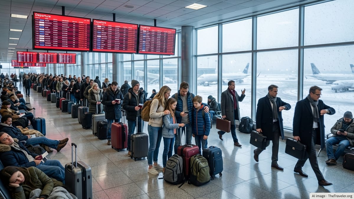
Severe thunderstorms sweeping across the Washington region have triggered significant flight disruptions at all three major DC-area airports, with delays, ground stops and cancellations rippling through schedules at Reagan National, Dulles and Baltimore/Washington International just as peak summer travel ramps up.
Get the latest news straight to your inbox!
Storms Collide With Peak Travel at DC’s Three Major Hubs
The latest round of thunderstorms moved through the Mid-Atlantic on Sunday evening, bringing damaging winds, intense lightning and heavy downpours across the Washington metropolitan area. Publicly available weather data shows strong cells crossing the Potomac River corridor and Northern Virginia suburbs, directly over key approach and departure paths serving Ronald Reagan Washington National Airport, Washington Dulles International Airport and Baltimore/Washington International Thurgood Marshall Airport.
Operational summaries indicate that the Federal Aviation Administration placed portions of the Northeast and Mid-Atlantic under severe weather traffic management initiatives, including ground delay programs and potential ground stops for the DC-area airports once convective activity intensified. An operations advisory issued late last week highlighted the possibility of ground stops or delay programs at Reagan National, Dulles and BWI after 2 p.m. local time, signaling that the storm risk was likely to intersect with the Sunday afternoon and evening rush of flights.
Regional outlets and aviation tracking services report that the Sunday storms followed several days of unsettled weather in the Mid-Atlantic, creating a volatile backdrop for air travel. Passengers flying into or out of the capital region over the weekend encountered rolling delays as airlines adjusted departure banks to fit into reduced arrival and departure rates dictated by air traffic control during thunderstorm impacts.
The disruptions come as DC-area airports are handling record or near-record passenger volumes. Recent airport authority figures show combined traffic at Reagan National and Dulles climbing to new highs in 2025, with strong demand continuing into 2026. That growth leaves less slack in the system when severe weather narrows the available airspace and runway configurations.
Reagan National Sees Tightest Squeeze on Capacity
Reagan National typically experiences the sharpest effects from convective weather because of its constrained airfield and river-adjacent location. The airport sits immediately across the Potomac from downtown Washington and relies on closely managed approach and departure corridors that are especially vulnerable when thunderstorms build over the city or drift along the river valley.
Performance data compiled by independent tracking sites indicates that on high-disruption days, average departure delays at Reagan National can stretch beyond one hour when weather cuts the airport’s effective throughput. Operational coverage of the recent storms describes a mix of cancellations and long holds as aircraft waited for slots through the constrained airspace serving the airport.
The situation at Reagan National has been further complicated by airline operational changes introduced earlier in the year. Industry coverage notes that one major carrier’s shift toward more digital customer service tools at the airport has coincided with a spate of weather-related disruptions, leaving some passengers struggling to rebook as thunderstorms force last-minute schedule overhauls. When severe weather hits an airport with limited runway capacity and tight slot controls, even modest delays can snowball into rolling cancellations late in the day.
For travelers, the impact often shows up as extended time on the tarmac, sudden gate changes and missed connections at downstream hubs. Publicly available reports from recent storm days at Reagan National describe passengers being offered rebooking through Dulles or BWI when nonstop options to the capital’s closest airport disappeared from the schedule.
Dulles and BWI Absorb Overflow but Face Their Own Disruptions
While Dulles has more physical runway capacity and is less tightly constrained by airspace than Reagan National, the airport is still highly sensitive to summer thunderstorms. FAA planning documents and airline communications consistently cite convective weather as one of the primary causes of delay cascades at Dulles, especially when storms roll off the Blue Ridge and cross main arrival corridors.
On recent storm days, live delay boards and passenger accounts have shown Dulles departures facing lengthy waits as traffic managers meter flows into the national airspace system. Because many Dulles flights connect to long haul international services, even moderate delays can push connections into misalignment, forcing airlines to rebook travelers or provide overnight accommodations when onward departures are missed.
Baltimore/Washington International, which rounds out the region’s three-airport system, has also been subject to the latest weather-related constraints. Carriers operating at BWI have issued travel waivers covering June dates for passengers booked through the airport during periods of anticipated East Coast thunderstorms, indicating that schedules were at risk not just in the DC core but across the broader Mid-Atlantic.
Regional travel patterns mean that disruptions at any one of the three airports can quickly spill over to the others. When thunderstorms or traffic management programs limit arrivals at Reagan National, for example, airlines sometimes shift capacity to Dulles or BWI, where there is more room to absorb diverted flights. The recent storms again underscored how closely linked the three airports are in practical terms for travelers trying to reach or depart the nation’s capital.
FAA Traffic Management Tools Stretch Out Delays
Publicly available FAA advisories show that traffic managers responded to the latest thunderstorms with a familiar toolkit: ground delay programs, reroutes around storm cells and the potential for temporary ground stops during the most intense periods of lightning and wind. One advisory issued late last week flagged the possibility of ground stops and delay programs for all three DC-area airports after midafternoon, a window that coincided with the strongest storms.
Ground delay programs effectively meter departures from other airports bound for a storm-affected destination by assigning them controlled departure times. While this reduces congestion in the skies near DC, it also lengthens delays at origin airports across the country, even in cities that are experiencing clear weather. Passengers bound for the capital region on Sunday reported extended waits at distant hubs as their flights were held to fit into the revised arrival rate for DCA, IAD and BWI.
In situations where storms sit directly over key approach paths or when controllers must vacate certain radar positions due to lightning or related safety concerns, ground stops can further tighten the system. During a separate incident earlier this year, a strong chemical odor at the air traffic control facility that manages approaches to the DC region forced a temporary halt to flights into the same trio of airports, illustrating how reliant regional operations are on a single control center.
Although Sunday’s disruptions were driven by thunderstorms rather than equipment or environmental issues, they produced a similar pattern from a traveler’s perspective: crowded terminals, long lines at service counters and complex rebooking scenarios as airlines tried to rebuild their schedules once the most severe weather passed.
What Travelers Can Expect in the Coming Days
Forecasts for the first half of the week indicate that the Washington region will remain in a warm, humid pattern conducive to additional showers and storms, particularly during afternoon and evening hours. While not every day will see severe weather, even scattered thunderstorms can trigger route adjustments and slower arrival rates if they form near established approach corridors.
Airlines have responded to the broader corridor of East Coast storms with flexible travel policies, including waivers that allow affected passengers to move their trips to alternate dates or nearby airports without change fees. Recent alerts have specifically listed the DC-area airports among locations where such waivers apply, signaling that carriers expect intermittent disruption to continue as storm chances persist.
Travel analysts frequently note that summer in the Mid-Atlantic is one of the most challenging periods for on time performance at DC-area airports, given the combination of afternoon thunderstorms, heavy passenger demand and limited opportunities to add extra flights once a wave is disrupted. The latest round of storms fits that pattern, underscoring the importance for travelers of building extra time into connections and monitoring flight status closely.
For now, publicly accessible tracking boards show operations gradually recovering after the most intense storm cells moved east of the region, but residual delays and aircraft re-positioning are likely to linger into Monday. With the heart of the summer travel season still ahead, the recent turbulence over the capital region offers an early signal of how quickly DC-area airports can move from routine operations to widespread disruption when thunderstorms build along the Potomac.