
Andrews Bald is one of the most rewarding short hikes in Great Smoky Mountains National Park, pairing a relatively modest effort with sweeping views and summer wildflowers. Yet first-time visitors are often unsure where the trail actually begins and whether the hike is suitable for their fitness level or family. Here is a clear, on-the-ground guide to where to start the Andrews Bald hike and what the difficulty really feels like once you are on the trail.
Get the latest updates straight to your inbox!
Where the Andrews Bald Hike Actually Starts
The standard route to Andrews Bald begins on the Forney Ridge Trail at the Kuwohi parking area, better known to most visitors as the Clingmans Dome parking lot. This large lot sits at the very end of Clingmans Dome Road, which branches off Newfound Gap Road roughly halfway between Gatlinburg, Tennessee, and Cherokee, North Carolina. When you pull into the lot, you are already at more than 6,000 feet in elevation, high on the crest of the Smokies.
From a practical standpoint, you will recognize the area by the small visitor contact station and the beginning of the steep, paved path to the Clingmans Dome observation tower. The key detail for Andrews Bald is that you do not follow this paved path. Instead, face the base of the paved tower trail and look to the left. You will see a signed dirt and gravel path marked Forney Ridge Trail. This is the true starting point for the Andrews Bald hike.
There is no separate “Andrews Bald parking” area and you do not need to hunt for a roadside pullout. Everything starts from the main Kuwohi / Clingmans Dome parking lot. In busy months the lot fills quickly by mid-morning, which is why many hikers aim to arrive between 8 and 9 a.m. In peak summer and October leaf season, mid-day arrivals may find rangers temporarily closing the access road when the lot is full, so an early start gives you the best chance of an easy parking experience.
Facilities at the trailhead are basic but useful. Seasonal vault toilets usually open once the road is open for the warm months, and there are often information boards with current park advisories. There is no drinking water, so you should arrive with enough water for your hike. For most adults, carrying at least one liter each is sensible, and more in hot, humid weather.
Trail Basics: Distance, Elevation, and Typical Timing
From the Forney Ridge Trailhead, it is about 1.8 miles one way to Andrews Bald, or roughly 3.6 miles round trip. Some GPS apps and hikers report the round trip as slightly over 4 miles, depending on the exact track and any extra wandering on the bald. Either way, you are talking about a half-day outing for most visitors rather than a full-day backcountry trek.
The hike is unusual for the Smokies in that it starts by descending from the high crest, then requires you to climb back up to return to the car. The net elevation loss from the trailhead down to the bald is roughly 500 to 600 feet, and the same amount must be gained on the way back. Many fitness trackers log around 700 to 800 feet of total climbing when the little ups and downs along the ridge are included.
In terms of time, reasonably fit hikers who are accustomed to walking on uneven ground often complete the round trip in 2 to 3 hours, including a short rest at the bald. Families with young children, photographers, and those taking frequent breaks might want to allow closer to 4 hours. If you are planning a sunset visit in summer, it is wise to check sunset time in advance and make sure you are comfortable hiking the forested trail back with headlamps if needed.
Because the trailhead sits above 6,000 feet and the bald itself around 5,900 feet, temperatures are often significantly cooler than in Gatlinburg or Cherokee. On a July afternoon when the towns are in the mid-80s Fahrenheit with heavy humidity, you might find mid-60s with a breeze on Andrews Bald. Even in late May or early October, a light jacket or fleece is often welcome if clouds move in or the wind picks up.
How Difficult Is Andrews Bald Really?
On paper, the hike is usually described as easy to moderate. Many trail apps list it as easy, while some regional hiking guides call it moderate mostly due to the rocky footing and the final climb back to the trailhead. In practical terms, most people who can comfortably walk 4 miles on uneven terrain at home and manage some stair-climbing will find Andrews Bald quite doable.
The first half-mile can feel surprisingly stout, not because of steep climbing but because the trail drops over a series of carefully built stone steps and rock segments. These were installed as part of a major trail reconstruction project to combat erosion, and they make the route more durable but also more uneven. On the way down, these steps are usually manageable, though hikers with knee issues may want trekking poles. On the way back up, this same stretch can feel like an extended staircase at altitude.
Beyond the initial improvement zone, the trail narrows into a classic Smokies footpath: dirt studded with roots and rocks, sometimes muddy after rain. In dry conditions, most reasonably sure-footed hikers, including older children, can navigate it without trouble if they take their time. After wet weather, slick rocks and roots are the main challenge, especially for those in smooth-soled running shoes or casual sneakers. Trail runners or light hiking shoes with grippy soles make the experience more secure.
If you are comparing Andrews Bald to other popular Smokies hikes, it is generally easier than Alum Cave or Chimney Tops, and noticeably shorter and less steep than the climb to Mount Le Conte. Many families treat it as their “warm-up” hike early in a trip before tackling something more strenuous, and it is often recommended as a good choice for visitors who want a backcountry feel without committing to an all-day workout.
Who This Hike Is Suitable For (and Who Should Think Twice)
Andrews Bald is a very popular choice for mixed groups. A couple in their 60s who walk daily but do not consider themselves athletes, a family with school-age kids, or travelers who spend most of their year at a desk often complete the hike comfortably with some breaks. Parents frequently report that children as young as six or seven manage the trail when given time and encouragement, especially with the promise of a picnic in the grassy clearing at the end.
That said, the rocky, irregular footing can be tiring for people who have significant balance problems or unstable ankles. The climb back up to the trailhead may feel taxing for visitors who are not accustomed to hills, especially at altitude. If you have chronic knee pain when descending stairs or steep hills, plan to descend carefully, possibly with the aid of poles, and take your time on the return climb. Many hikers find that pausing briefly at each switch in grade keeps their breathing comfortable without extending the day too much.
The trail is not suitable for strollers or wheelchairs. The stone steps, roots, and narrow sections mean that children need to be either walking independently or carried in a proper child carrier pack. If you are hiking with a child in a backpack carrier, remember that your footing is more critical and your balance can be affected by the extra weight; trekking poles can be especially helpful in this scenario.
For visitors with limited time or very low fitness, simply walking a short distance down the Forney Ridge Trail to experience the spruce-fir forest and then turning around may be enough. You will not reach the open bald, but you will still get a sense of the high-elevation environment surrounding Kuwohi without committing to the full hike and climb back.
Seasonal Access, Weather, and Trail Conditions
One of the easiest mistakes travelers make when planning an Andrews Bald hike is overlooking the seasonal closure of Clingmans Dome Road. Typically the access road is closed to vehicles from around December into early April, depending on conditions. When the road is closed, you cannot drive to the Kuwohi parking area, and reaching the Forney Ridge Trailhead would require an 8-mile walk each way on the road from Newfound Gap, which turns a family-friendly outing into a demanding full-day winter trek.
From late spring through fall, the road is usually open daily, though it may close temporarily during late-season snow, ice, or severe storms. Before committing to an early-season hike in April or a late fall visit in November, it is smart to check the latest park conditions. Even in May, you can encounter patches of lingering snow or ice on shaded parts of the trail if a late cold snap has passed through.
Weather on the high ridges of the Smokies changes quickly. It is common for hikers to start the day under clear blue skies in Gatlinburg and find dense clouds or light drizzle at the trailhead. On humid summer afternoons, brief but intense thunderstorms can sweep across the mountains. Because much of the Andrews Bald route is sheltered in forest, you are somewhat protected from direct wind, but you still need to be prepared for rain and cooler air. A lightweight waterproof shell and a small dry bag for your phone and camera are practical additions to even a short day pack.
The trail itself is generally well maintained, but after heavy rains, water may run down sections of the path, creating muddy stretches or puddles between rocks. In these conditions, shoes with good traction and a willingness to step carefully from stone to stone make the hike more enjoyable. During the height of summer, the high-elevation forest where the trail runs tends to have fewer biting insects than lower valleys, but ticks and mosquitoes can still be present on warm days, so basic precautions like long socks and a bit of insect repellent are wise.
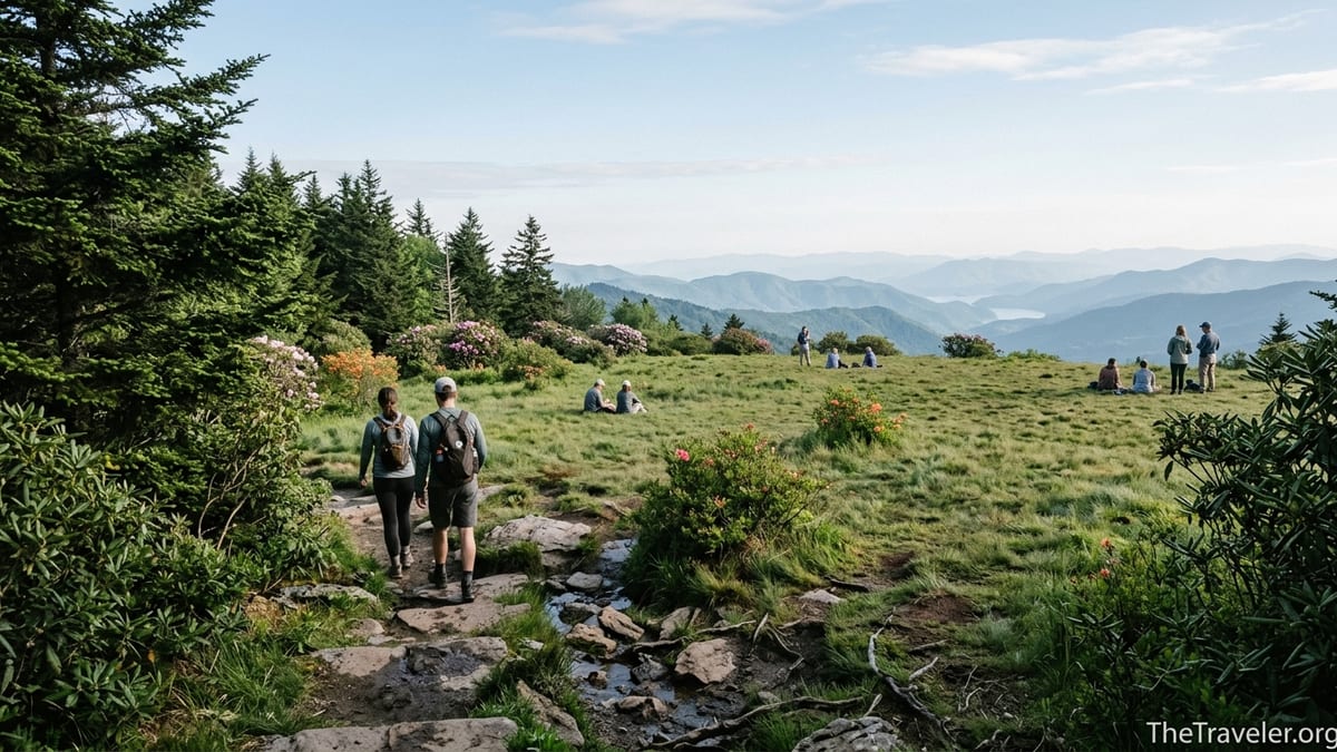
What You Will See Along the Way
From the very start, the Andrews Bald hike immerses you in a high-elevation spruce-fir forest, something many visitors associate more with New England or the Canadian border than with Tennessee and North Carolina. The air often feels cooler and carries the resinous scent of fir needles and damp moss. Fallen logs, thick groundcover, and occasional standing dead snags hint at the natural disturbances and insect damage that have shaped these ridges over the last century.
In late May and June, one of the biggest draws is the floral display. The bald is famous for its Catawba rhododendron and flame azalea, which can paint the meadow edges in shades of pink and fiery orange. On a clear June morning, it is common to see photographers setting up tripods on the grass to capture these blooms backlit by the rising sun over the layers of Smoky Mountain ridges.
Wildlife sightings are usually subtle but rewarding. Dark-eyed juncos and other high-elevation birds are frequent companions along the trail, flitting in and out of the underbrush. Red squirrels, chipmunks, and occasional salamanders under damp logs are the kinds of wildlife most hikers notice. Black bears live in the region, but actual encounters on this short, busy trail are uncommon. Still, hikers should give any wildlife plenty of space, keep food securely packed away, and never leave snacks unattended on the bald.
When you step out onto Andrews Bald itself, the forest suddenly opens to a gently rolling grassy expanse with scattered low shrubs and stunted trees. On clear days you can see long views toward the south and west, often including glimpses of Fontana Lake and multiple overlapping blue-gray ridgelines. Many hikers spread out a picnic blanket, take off their shoes in the grass, and linger for half an hour or more simply enjoying the space and the breeze before starting back.
Practical Tips for a Smooth Andrews Bald Hike
Because the hike begins at such a popular destination, timing can transform your experience. Arriving at the Kuwohi parking area before 9 a.m. typically means easier parking and a quieter trail. If you arrive closer to midday in July or October, you may circle the lot looking for a space, and you will likely share the trail with many more hikers. Some local guiding companies even suggest pairing Andrews Bald with an early or late visit to the Clingmans Dome tower to enjoy both views with minimal crowding.
Shoes are one of the most important gear choices. Lightweight trail running shoes with moderate tread or low-cut hiking shoes are ideal. Thin-soled street sneakers or fashionable canvas shoes tend to slip more on wet rock and leave feet sore from the uneven steps. A small day pack with water, a snack, a rain layer, sunscreen, and a basic first-aid kit is usually sufficient. Trekking poles, while not mandatory, are a worthwhile addition for anyone with joint concerns or who simply prefers extra stability.
If you are coming from Gatlinburg, expect the drive to the Clingmans Dome road junction to take around 45 minutes in normal traffic, and then another 15 to 20 minutes up the side road to the parking area. From Cherokee, the timing is similar. During busy holiday weekends, allow extra time for slow-moving traffic on Newfound Gap Road. Many visitors build the Andrews Bald hike into a broader day that might include scenic stops at Newfound Gap overlook or a picnic at one of the pullouts along the main highway.
Finally, think about your return timing. If you plan to watch sunset from the bald, pack headlamps with fresh batteries for everyone in your group. The forested trail becomes quite dark under the canopy even before official sunset, and phone flashlights are awkward to hold on uneven steps. Starting your hike no later than 90 minutes before sunset usually gives you enough leeway to enjoy the light at the bald and still hike back without rushing.
The Takeaway
The Andrews Bald hike is straightforward to reach once you know that everything begins at the Forney Ridge Trailhead beside the Clingmans Dome / Kuwohi parking lot. There is no hidden trailhead or confusing network of side roads, just a single well-signed path dropping off the well-known crest of the Smokies.
In terms of difficulty, it occupies that appealing middle ground: more of an adventure than a roadside overlook, but well within reach for most reasonably active visitors. The combination of moderate distance, modest but real elevation change, and an uneven, rocky path means you should treat it with respect, but you do not need to be a seasoned backcountry hiker to enjoy it.
With sensible preparation, the right footwear, and a bit of awareness of the high-elevation weather and road opening dates, Andrews Bald can be one of the most memorable half-day outings of a Smokies trip. From early-summer azalea blooms to crisp autumn vistas, this grassy mountaintop clearing offers a classic Great Smoky Mountains experience for those willing to walk just a few miles beyond the pavement.
FAQ
Q1. Where exactly do I start the Andrews Bald hike?
The hike starts on the Forney Ridge Trail at the Kuwohi / Clingmans Dome parking area, at the end of Clingmans Dome Road off Newfound Gap Road. From the base of the paved tower trail, look left for the signed Forney Ridge Trail.
Q2. How long is the hike to Andrews Bald?
The standard out-and-back route is about 1.8 miles each way, or roughly 3.6 miles round trip. Some GPS tracks measure slightly over 4 miles depending on how much you explore the bald.
Q3. How hard is the Andrews Bald hike for a beginner?
Most beginners who can walk several miles on uneven ground and handle some hills find it manageable. The rocky steps and the uphill return can feel challenging, but frequent breaks help a lot.
Q4. Can kids do the hike to Andrews Bald?
Yes, many families hike it with school-age children. Kids around six or seven and older usually do well if you allow plenty of time, bring snacks, and let them rest at the bald before heading back.
Q5. Is the trail stroller or wheelchair accessible?
No. The Forney Ridge Trail has stone steps, rocks, roots, and narrow sections, so it is not suitable for strollers or wheelchairs. Babies and toddlers need to be in child carrier packs if they are not walking.
Q6. When is the road to the trailhead open?
Clingmans Dome Road, which leads to the trailhead, is generally open from around April to late fall, then closed to vehicles in winter. Exact opening and closing dates vary with weather and maintenance.
Q7. What kind of shoes should I wear for Andrews Bald?
Wear shoes with good grip and support, such as trail runners or light hiking shoes. The route includes wet rocks, roots, and uneven stone steps that can be slick in damp conditions.
Q8. Is Andrews Bald crowded?
The trail can be busy during summer and autumn weekends because it shares a parking area with Clingmans Dome. Starting early in the morning or later in the afternoon usually means fewer people on the trail and at the bald.
Q9. Do I need a permit or to pay extra to hike Andrews Bald?
You do not need a separate hiking permit for this day hike, but the park may require a parking or access fee that you pay at designated machines or kiosks when you arrive in the area.
Q10. Is Andrews Bald a good place for sunrise or sunset?
Yes, many hikers enjoy sunrise or sunset from the bald because of its open views. If you go at these times, carry headlamps and warm layers, and be prepared to hike the forested trail in low light.