
Ask a ranger or a Gatlinburg local to name the one waterfall hike everyone seems to be talking about in Great Smoky Mountains National Park right now, and Laurel Falls almost always tops the list. The short, partially paved trail to an 80‑foot cascade has gone from a family favorite to a case study in what happens when a “picture‑perfect, easy walk” becomes a viral must‑do. With more than 300,000 visitors a year and an 18‑month rehabilitation project now underway, Laurel Falls is the waterfall hike that defines both the magic and the growing pains of the modern Smokies.
Get the latest updates straight to your inbox!
From Modest Footpath to the Park’s Most Talked‑About Waterfall
Laurel Falls did not start out as a high‑traffic Instagram star. The trail was originally built in the 1930s, when Civilian Conservation Corps crews cut a path up the wooded slopes above what is now Fighting Creek Gap Road. It was a fairly typical Smokies footpath: dirt underfoot, laurel and rhododendron crowding the edges, and a local reputation that stopped at nearby communities like Gatlinburg and Townsend.
As visitation to Great Smoky Mountains National Park climbed over the decades, park managers noticed something different about this particular waterfall walk. The route is just over 2.5 miles round trip, with about 300 feet of elevation gain, which puts it firmly in the “easy but not boring” category that appeals to multigenerational families, tour groups, and first‑time hikers. Long before hiking apps and social media, the park was already describing Laurel Falls in printed trip planners as one of its most popular destinations, signaling that word of mouth had begun to spread far beyond Tennessee and North Carolina.
That demand drove a major decision: the park eventually paved the trail’s main 1.3‑mile approach to reduce erosion caused by the constant foot traffic. Today, Laurel Falls is consistently described in guidebooks as one of the most heavily used trails in the Smokies, and it is singled out in overviews of park hiking as probably the single most popular waterfall hike, rivaled only by Abrams Falls out of Cades Cove and Rainbow Falls above Gatlinburg.
By the early 2000s, Laurel Falls had become a shorthand recommendation in visitor centers and local hotels. Ask the front desk at a mid‑range Gatlinburg property along the Parkway where to find an “easy waterfall for kids,” and Laurel Falls is almost always in the first breath, right alongside suggestions like Grotto Falls or the Gatlinburg Trail. That reflexive recommendation, repeated thousands of times each year, helped lock the hike into its current must‑see status.
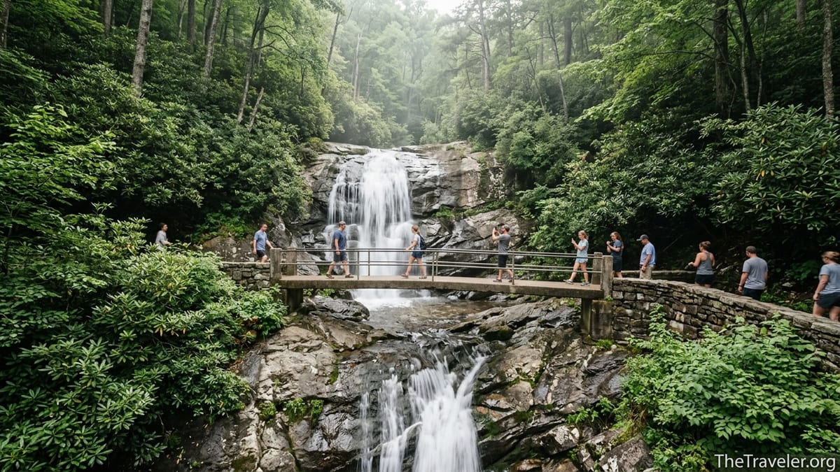
A Near‑Perfect Mix of Easy Access and Big Payoff
The simplest explanation for the trail’s fame is also the most practical: Laurel Falls offers a big visual reward for relatively little effort. The trailhead sits directly off Fighting Creek Gap Road, only a short drive from Sugarlands Visitor Center, which itself is just minutes from the shops and cabin resorts that line Gatlinburg. Many visitors leave a breakfast buffet in town and can be at the parking area in roughly 15 to 25 minutes, depending on traffic.
From there, the climb is steady but never extreme. Families regularly tackle the hike in athletic shoes rather than full hiking boots. A visitor staying in a budget hotel off U.S. 441 might squeeze Laurel Falls in between a morning at Ripley’s Aquarium and an afternoon coaster ride, something not possible with more demanding routes like Alum Cave or Mount Le Conte. For travelers with only one or two days in the park, that kind of time efficiency matters as much as scenery.
At the top, the trail delivers a classic Smokies scene. Laurel Falls plunges in two distinct tiers, dropping roughly 80 feet over a rock ledge thick with moss and ferns. A narrow concrete footbridge crosses the stream right at the break between upper and lower cascades, putting visitors practically inside the spray. On warm afternoons you will see kids leaning over the stone rail to feel the mist and couples asking strangers to snap photos with the waterfall filling the background.
The experience feels undeniably “backcountry” to many first‑time visitors, even though the hike never strays far from the main park road. Black bear sightings are common enough that rangers post frequent warnings, and sudden summer thunderstorms can turn the polished pavement slick in minutes. It is that combination of accessible adventure and genuine wildness that leaves such a strong impression, and that hikers then carry home to friends, family, and social networks.
Social Media, Smartphone Maps, and the Viral Waterfall Effect
Laurel Falls benefitted enormously from the rise of photo‑driven travel planning. Search for “Smoky Mountains waterfall hike” on major image platforms and the same scene repeats again and again: a narrow bridge, families squeezed shoulder to shoulder on the stone wall, and the curtain of white water framed by rhododendron. Those images circulate widely in trip planning groups, on short‑form video apps, and inside the review galleries of booking sites that sell cabins, hotels, and vacation packages around Gatlinburg and Pigeon Forge.
Smartphone navigation amplified that exposure. The trailhead appears clearly in popular map apps, and directions from central Gatlinburg or Pigeon Forge are as simple as selecting “Laurel Falls Trailhead” and following the blue line. For first‑time visitors to national parks, especially those who may feel intimidated by topographic maps or paper brochures, that digital clarity removes a barrier. You no longer have to study a park map for an hour to find a family‑friendly waterfall. A couple on a weekend getaway can finish lunch on the Gatlinburg strip, pull up directions on a phone, and be at the trailhead before their coffee gets cold.
Reviews on major travel and trail‑rating sites reinforce the hike’s reputation. Laurel Falls is commonly tagged as “easy,” “family‑friendly,” and “a must‑do if you only have one day,” often with practical details attached. Travelers mention that parking spaces directly at the trailhead routinely fill before mid‑morning in peak seasons, and some describe arriving as early as 7:30 a.m. to secure a spot near the start of the trail. Others recount navigating long lines of cars on Little River Road as people circle and wait for spaces to open.
Local businesses echo this messaging. Visitor guides handed out in Gatlinburg restaurants and souvenir shops often highlight Laurel Falls alongside icons like Newfound Gap and Clingmans Dome. A free map from a local coupon magazine in 2026, for example, touts Laurel Falls as offering “the easiest waterfall access” via a paved trail, language that resonates strongly with travelers who want the reward of a waterfall without committing to a strenuous backcountry adventure.
Crowds, Parking Jams, and the Park’s Response
What made Laurel Falls famous has also made it one of the Smokies’ most challenging sites to manage. Great Smoky Mountains National Park is the most visited national park in the United States, drawing well over 10 million people annually. On busy days in October leaf season or mid‑summer, congestion on major roads and at popular trailheads is now a defining part of the visitor experience, and Laurel Falls sits at the center of that reality.
Before recent management changes, visitors often parked along both sides of Fighting Creek Gap Road, sometimes stretching a mile or more in each direction. That roadside parking created obvious safety problems. Families with small children and dogs were stepping out of vehicles into narrow lanes as traffic rounded curves, and drivers trying to squeeze into informal shoulder spots damaged vegetation and eroded the steep road banks.
In response, the park began blocking unsafe roadside parking and testing new congestion strategies. In 2021, managers launched a pilot program that required timed parking reservations at Laurel Falls during a late‑summer and early‑fall window. Under that system, visitors reserved a specific two‑hour slot to park at the trailhead, much like reserving a time to enter a museum exhibit. Feedback was mixed. Some locals appreciated that they could finally plan a visit without circling endlessly for parking, while others disliked the added layer of planning and the perception of reduced spontaneity.
The park has also moved toward more defined, designated parking in the corridor and is actively working on a longer‑term solution. The current Laurel Falls Trail Management Plan envisions improved parking areas and safer pedestrian circulation, paired with trail rehabilitation, so that visitors can reach the falls without overcrowding the shoulders of the road. For travelers arriving in peak periods, this shift means that the old habit of simply pulling off anywhere along Little River Road is quickly becoming a thing of the past.
Safety, Misconceptions, and the Reality of an “Easy” Trail
One reason Laurel Falls generates so much conversation is the gap between expectations and reality. Many people hear “paved, 2.6 miles round trip” and imagine a park‑like promenade suitable for flip‑flops and lightweight strollers. The truth on the ground is more complicated. The pavement is old and uneven in places, with broken edges, standing water after storms, and steep drop‑offs on the downhill side of the trail.
Rangers and experienced hikers regularly warn that standard baby strollers struggle on the route, and that the trail is not truly wheelchair accessible, despite the hard surface. Travel forums are filled with stories from visitors who pushed a stroller up the hill only to find themselves wrestling it over broken sections of asphalt near the top. Others describe seeing children scramble onto slick rocks near the edge of the falls while adults position cameras, prompting stern reminders that people have been injured and even killed at falls in the Smokies when they slipped into swift water.
The footbridge at the falls, while iconic, can be a bottleneck. On crowded days, hikers queue along the approach, waiting their turn to cross and pose for photos. The rock ledges on either side are narrow, and there is limited space to sit or rest. Visitors who arrive expecting a quiet picnic on a broad slab may be surprised to find themselves quickly stepping aside for the next family rotation.
Wildlife encounters add to both the allure and the risk. The dense berry thickets and oak forests along the Laurel Falls corridor are good bear habitat, and the park occasionally issues bear warnings for the trail when animals become active around people. On any given summer day, a group from a downtown Gatlinburg motel might return with stories of a bear crossing the trail 30 yards ahead or a sow and cubs foraging on a slope. The park’s message is consistent: keep your distance, carry basic safety gear like a small first‑aid kit and rain jacket, and treat even popular trails as real mountain hikes rather than amusement‑park attractions.
The 18‑Month Closure and What Comes Next
The very success of Laurel Falls has worn down the trail and surrounding infrastructure. In January 2025, the National Park Service closed the Laurel Falls Trail for an estimated 18 months to undertake a major rehabilitation project. During this period, the route from the main trailhead up to its junction with Little Greenbrier and Cove Mountain is off limits, with rangers turning people back at the road and signs clearly stating that the trail is closed for construction.
The project focuses on stabilizing and improving the tread, replacing aging drainage culverts, and addressing erosion that has undercut sections of pavement. The plan also envisions safer, more sustainable access to the falls area, so future visitors can enjoy the iconic bridge and cascades without the constant worry of slipping on crumbling asphalt or squeezed shoulders above steep drop‑offs. For travelers accustomed to dropping into Laurel Falls on every Smokies visit, the closure has been a jolt, but it is also a sign that the park is investing in one of its most beloved spots.
In tandem with trail repairs, managers are evaluating parking and congestion more broadly. Planning documents describe designated parking areas to serve both Laurel Falls and nearby Sugarland Mountain, reducing the chaotic mix of roadside vehicles that once defined the corridor. That could eventually mean a more predictable experience for visitors: clear signs indicating when lots are full, potential shuttle options during peak periods, and better separation between moving cars and people on foot.
During the closure, rangers and local tourism offices have been steering waterfall‑hungry visitors to alternatives. Families who would once have defaulted to Laurel Falls are now discovering destinations like Cataract Falls near Sugarlands Visitor Center, the easier sections of Deep Creek’s waterfall loop on the North Carolina side, or Hen Wallow Falls from the quieter Cosby area. In the long run, that redistribution may actually help Laurel Falls by easing some of the pressure when it reopens.
How Laurel Falls Shapes the Way Visitors Experience the Smokies
Laurel Falls has become a gateway experience, especially for first‑time visitors whose only previous sense of the Smokies came from postcards, car commercials, or online travel ads. For a family who has just driven eight hours from the Midwest and checked into a cabin resort off the Spur, the hike often functions as their first real step into the national park’s backcountry. Success on that trail builds confidence. Parents realize their kids can manage a couple of uphill miles, grandparents discover they can still climb to a scenic destination, and everyone leaves with a renewed appetite for more trails.
This ripple effect is visible in trip itineraries that start with Laurel Falls and then expand outward. After tackling the waterfall, travelers frequently add destinations like Clingmans Dome, the Gatlinburg Trail, or a loop through Cades Cove to see historic cabins and perhaps hike to Abrams Falls. Outfitters in town notice patterns too. Staff at small outdoor shops near the Parkway report that customers often buy their first pair of real hiking socks or collapsible trekking poles after spending an unexpectedly tiring morning at Laurel Falls in regular sneakers.
At the same time, the crowds at Laurel Falls are teaching park managers and visitors alike hard lessons about carrying capacity. Seeing dozens of people clustered at a narrow bridge has sparked conversations about what “too crowded” means in a national park and how to balance broad public access with a sense of solitude. The Laurel Falls congestion pilots, parking restrictions, and rehabilitation plans are likely to influence how the Smokies handles other high‑use sites in the coming decade.
For the travel community, Laurel Falls has become a touchstone in debates about responsible tourism. Guidebook authors increasingly encourage visitors to adjust expectations, arrive early or late in the day, and seek out lesser‑known waterfalls if they prioritize quiet over social energy. Travel writers now routinely pair Laurel Falls recommendations with mentions of alternatives such as Ramsey Cascades for strong hikers or quieter creeks off the Greenbrier and Cosby roads, framing the famous hike as one option in a broader menu rather than the only way to experience water in the park.
The Takeaway
Laurel Falls became the waterfall hike everyone talks about in the Smokies because it sits at the sweet spot between accessibility and adventure. A short drive from Gatlinburg, a manageable paved climb, and a dramatic 80‑foot cascade with a footbridge perfectly positioned for photos all but guaranteed its fame in the age of social media and smartphone navigation. Families, first‑time hikers, and tour groups can all reach the falls in a single morning, and that shared accessibility has turned the trail into a cultural reference point for what a Great Smoky Mountains hike feels like.
That popularity, though, has brought serious challenges. Congested parking, crowded viewpoints, uneven pavement, and wildlife pressures have forced Great Smoky Mountains National Park to rethink how Laurel Falls is managed. The current 18‑month closure for rehabilitation is a direct response to those pressures and a signal that the park is committed to preserving the experience for future generations, even if that means short‑term inconvenience.
For travelers planning trips in the next couple of years, Laurel Falls offers two intertwined lessons. First, iconic experiences rarely stay secret, and visiting them now requires a bit of strategy: checking trail status, timing visits carefully, and being realistic about crowds. Second, the Smokies are full of other waterfalls and forest walks that can deliver the same sense of wonder with fewer people. By pairing the famous with the lesser‑known, visitors can honor what made Laurel Falls special while helping spread out impact across the park.
When the trail reopens, hikers will likely find a familiar scene made safer and more sustainable. The bridge will still slice the waterfall into upper and lower curtains. Mountain laurel will still bloom along the slopes that gave the falls its name. And people leaving the trailhead will still be talking about the hike, not only for its beauty, but for what it represents in the evolving story of America’s most visited national park.
FAQ
Q1. Is Laurel Falls Trail open right now?
As of mid‑2026, Laurel Falls Trail is closed for an extended rehabilitation project that began in January 2025, with completion expected in late 2026; travelers should confirm current status with the park before visiting.
Q2. How long and difficult is the hike to Laurel Falls?
The hike is roughly 2.6 miles round trip with about 300 feet of elevation gain. It is generally rated easy to moderate because the grade is steady but the pavement is uneven in places.
Q3. Is the Laurel Falls Trail really paved the whole way?
The main approach to the falls is paved for about 1.3 miles one way, but the surface is old and broken in spots, with some short, rougher sections near the top that feel more like a traditional forest trail.
Q4. Can I take a stroller or wheelchair to Laurel Falls?
Although the trail is paved, it is not recommended for standard strollers or wheelchairs because of steep slopes, rough pavement, and drop‑offs. Many visitors find strollers difficult to manage, especially near the falls.
Q5. How early should I arrive to find parking at Laurel Falls when it is open?
On busy days when the trail is open, parking at the trailhead typically fills by mid‑morning, and some visitors aim to arrive before 8 a.m. or later in the afternoon to improve their chances of getting a designated spot.
Q6. Do I need a reservation or permit to hike Laurel Falls?
The park tested timed parking reservations for Laurel Falls during a 2021 pilot. Any future use of reservations or permits will depend on park decisions, so visitors should always check current regulations before they go.
Q7. Is it safe to swim at Laurel Falls?
The area around the falls has slick rocks, swift water, and steep drop‑offs, and the park strongly discourages wading or swimming there. Visitors are advised to enjoy the view from the trail and bridge.
Q8. Are there bears on the Laurel Falls Trail?
Black bears live throughout the Smokies, and sightings occasionally occur along Laurel Falls. Hikers should keep a safe distance, store food properly, and follow all park guidance on wildlife encounters.
Q9. What are good alternative waterfall hikes while Laurel Falls is closed?
While Laurel Falls is closed, families often visit Cataract Falls near Sugarlands Visitor Center, the waterfalls along Deep Creek, or other popular routes like Abrams Falls, Grotto Falls, and Hen Wallow Falls.
Q10. What should I bring if I plan to hike Laurel Falls when it reopens?
Plan on sturdy walking shoes, water, a light rain jacket, and basic sun protection. Even though the hike is short, treat it like any mountain trail and be prepared for changing weather and crowds.