
More news on this day
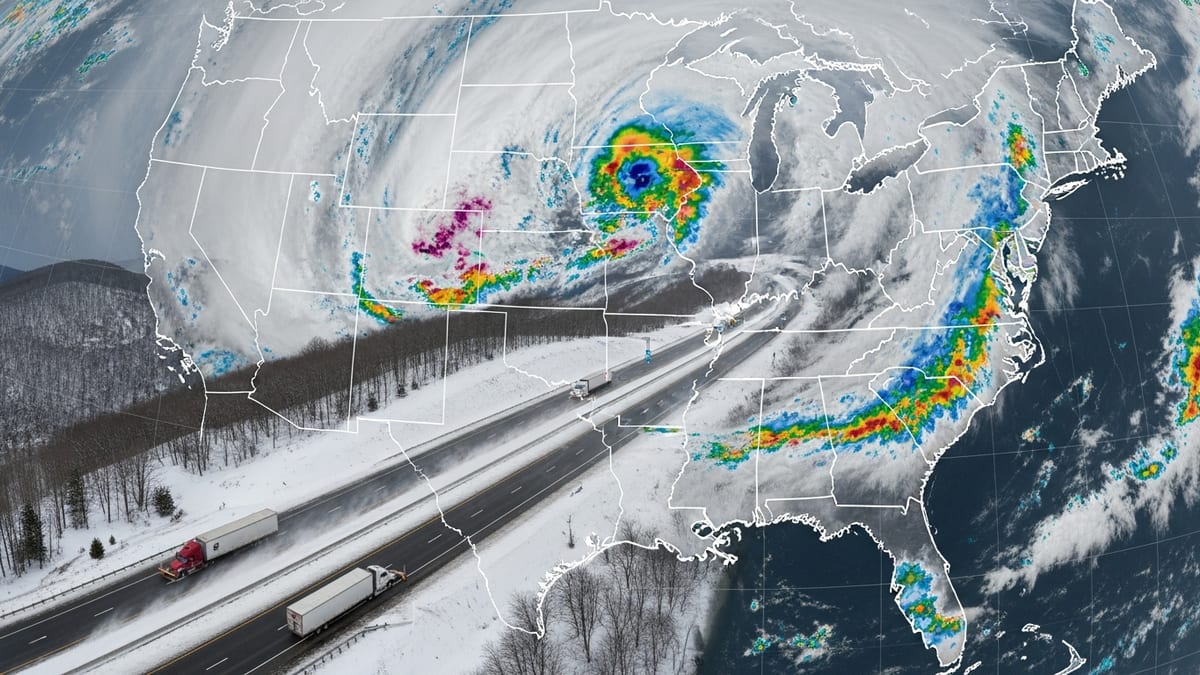
A powerful cold-season storm is forecast to deliver up to 32 inches of heavy, wet snow and winds near 60 miles per hour in parts of the northern and western United States this week, creating hazardous road conditions, potential power disruptions, and rapidly changing travel plans at higher elevations.
Get the latest news straight to your inbox!
Early-Season System Brings Midwinter Conditions
Publicly available forecasts from the National Weather Service and regional forecast offices indicate that an unusually strong Pacific storm moving inland will collide with cooler air over the interior West and northern Rockies, producing midwinter-style conditions even as much of the country experiences typical summer weather.
Forecast discussions describe a corridor of very heavy, elevation-driven snow, with the highest totals expected along mountain passes and ridgetops where upslope flow enhances snowfall rates. In some favored locations, projections show totals approaching 32 inches, with widespread lower-elevation accumulations several inches deep.
According to published coverage from national weather outlets, the storm’s track is expected to carry it from the Pacific Northwest into the northern Rockies and higher terrain of the northern Plains, with snow focused mainly above roughly 6,000 to 7,000 feet. Valley locations are more likely to see cold rain mixed with wet snow, but brief accumulations are still possible where heavier bands pass overhead.
Although late June and early July storms of this magnitude are rare, long-term climatological records show that deep, cold-core systems can occasionally produce heavy mountain snow well into the warm season, particularly where lingering snowpack and cool air aloft remain in place.
Winter Storm Warnings Highlight Heavy, Wet Snow Risks
Winter storm warnings now in effect for portions of the northern Rockies and adjacent high terrain emphasize the threat of heavy, wet snow, which is often more hazardous than lighter, powdery snow despite similar accumulation totals. Weather safety guidance from multiple state emergency management agencies notes that heavy, dense snow exerts far greater weight on trees, roofs, and power infrastructure.
When totals approach 2 to 3 feet, especially in a short window of time, the added weight can break tree limbs, down lines, and clog high mountain roads. Preparedness materials from several state winter weather guides classify six inches or more of heavy snow in less than 48 hours as a significant event for transportation and utilities, with greater impacts expected as amounts increase.
Travel-focused briefings from forecasters stress that conditions over mountain passes and backcountry roads could deteriorate quickly once snow begins to accumulate on colder surfaces. Slush and compacted snow may reduce tire traction, while ruts and drifts can form where gusty crosswinds push snow across exposed roadways.
In addition, the combination of heavy precipitation and temperatures hovering near the freezing mark can create a narrow zone of mixed rain and snow, where icy patches may develop on bridges, ramps, and shaded curves, catching motorists off guard.
Wind Gusts Near 60 mph to Create Whiteout Conditions
Along with the heavy snow threat, the storm is forecast to produce widespread strong winds, with gusts approaching or reaching 60 miles per hour in exposed high terrain and along ridge tops. National and state-level hazard descriptions explain that wind gusts above roughly 50 to 60 miles per hour are capable of producing difficult crosswinds for high-profile vehicles, scattered tree damage, and sporadic power outages.
At the same time, strong winds will significantly worsen visibility where snow is falling. Even in areas that receive less overall accumulation, blowing and drifting snow can reduce visibility to a quarter mile or less at times, creating near-whiteout conditions over passes and open stretches of highway.
Winter weather safety information from multiple public agencies notes that blizzard-like conditions do not necessarily depend on extreme snowfall totals, but rather on the combination of wind and visibility. In this case, while the primary alert in many areas remains a winter storm warning, the overlap of heavy, wet snow and powerful gusts will likely produce travel conditions similar to a blizzard over short periods.
These hazards may persist even after the heaviest snow tapers off. Loose snow on roadways and shoulders can be picked up by lingering winds overnight, re-covering plowed surfaces and reducing visibility in sudden bursts, especially in open country and high plateaus.
Travel Disruptions Likely Across Mountain Corridors
Forecast briefings and media analyses suggest that the most significant travel disruptions will occur along key mountain corridors where long-distance highway and freight routes cross high passes. Drivers using these routes for regional tourism, camping trips, or early-summer hiking excursions may encounter chain controls, closures, or delays if conditions deteriorate faster than expected.
Air travel may also see secondary effects, as mountain weather can affect regional feeder flights and small airports that serve gateway communities for national parks and outdoor destinations. Low ceilings, strong crosswinds, and runway contamination from slush or snow can lead to schedule changes or diversions at smaller regional hubs.
Travel-focused coverage indicates that, in past storms of similar character, impacts have extended beyond the core heavy-snow zone. Long-haul drivers and road trippers may face slower traffic and residual delays hundreds of miles downstream as plow operations, wrecks, and reduced speeds ripple through transportation networks.
With the storm expected to unfold over several days, conditions are likely to change rapidly along any given route. Periods of relative calm could be followed by intense bands of snow and wind, making it essential for travelers to monitor updated forecasts and road condition reports before committing to remote or high-elevation segments.
What Travelers Should Watch for This Week
Winter weather preparedness guidance from federal and state agencies recommends that anyone planning travel into the affected high-elevation areas carry extra clothing, food, water, and a basic winter car kit, even in late June and early July. Items commonly listed in official checklists include a small shovel, traction aids or chains where permitted, a flashlight, blankets, and jumper cables.
Forecasters and travel analysts underscore the importance of flexibility in itineraries during significant storms, particularly for visitors unfamiliar with driving in snow. Public information materials often advise postponing nonessential trips when winter storm warnings are in effect for mountain areas, or at minimum planning alternate routes at lower elevations where conditions may be less severe.
Outdoor recreation plans are also likely to be affected, as deep snow and strong winds can quickly change backcountry conditions. Avalanche danger can increase where heavy, wet snow falls on older, weaker snowpack, and visibility issues can complicate navigation for hikers and climbers on exposed ridges or open terrain.
For many travelers, the safest option will be to closely track the evolving forecast, allow extra travel time, and stay prepared for sudden weather changes. While the storm will deliver a picturesque early dose of winter to the peaks, the combination of heavy, wet snow and winds near 60 miles per hour means that conditions may be far more challenging than typical early-summer mountain showers.