
Andrews Bald is one of the most rewarding short hikes in Great Smoky Mountains National Park, combining a moderate workout with sweeping high-country views and open meadows. Starting near the summit area of Kuwohi (still widely known as Clingmans Dome), the trail drops off the crowded pavement to a quieter path through spruce fir forest before emerging onto a grassy bald perched above a sea of blue ridges. This guide walks you through the distance, elevation, logistics, and on-the-ground experience so you know exactly what to expect before you lace up your boots.
Get the latest updates straight to your inbox!
Where Andrews Bald Is and Why It Is Special
Andrews Bald sits on Forney Ridge in the southern half of Great Smoky Mountains National Park, reached from the large parking area at Kuwohi / Clingmans Dome. The bald itself is a high-elevation meadow at roughly 5,900 feet, making it one of the highest grassy balds in the park and in the broader Southern Appalachians. On clear days you look south into the rolling ridges of North Carolina, with deep blue layers of mountains that feel a world away from the busy highways below.
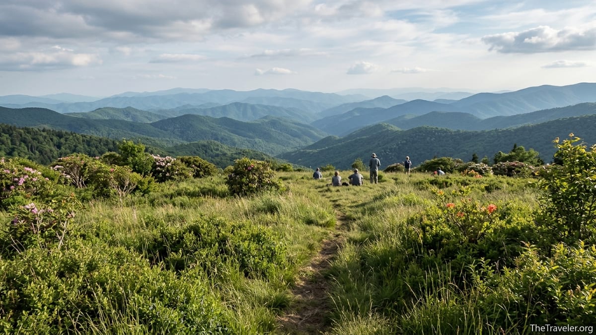
Unlike some Smokies viewpoints that are simply rocky overlooks, Andrews Bald offers a broad, gently sloping meadow dotted with shrubs, low blueberry bushes, and pockets of spruce fir. In late spring and early summer, rhododendron and flame azalea add bright pinks and oranges to the landscape, and in late summer you may find wild blackberries along the edges. Many hikers bring a blanket and picnic and stay for an hour or more because the setting feels more like a high-country pasture than a narrow summit ledge.
The trail begins in Tennessee at the Clingmans Dome parking area but quickly crosses into North Carolina as it follows Forney Ridge. This borderland location, combined with the high elevation, means temperatures are often 10 to 20 degrees cooler than nearby towns like Gatlinburg, Cherokee, or Bryson City. That cooler air makes Andrews Bald an appealing half-day escape during the humid Southern summer.
Trail Distance, Elevation Gain and Difficulty
The standard route to Andrews Bald uses the Forney Ridge Trail from the Clingmans Dome parking area. From the signed trailhead, you will hike about 1.8 miles one way to reach the bald, for a total of roughly 3.5 to 3.6 miles round trip. Most hikers complete the outing in 2 to 3 hours, depending on fitness, how often they stop for photos, and how long they spend relaxing in the meadow.
The total elevation change is moderate but not trivial. Expect around 800 to 900 feet of cumulative elevation gain over the round trip, with some sources listing about 899 feet. One important detail is that the trail initially descends from the trailhead, meaning you hike downhill on the way out and then must climb back up toward the parking lot at the end of your hike. Visitors who are used to trails that start with a climb and end with a descent sometimes find this mentally surprising, especially when they are tired and ready for the car.
In practical terms, most reasonably fit adults who walk regularly will find Andrews Bald to be a moderate hike. Families with school-age children often manage it without trouble, though younger kids may need frequent snack breaks. The trail includes plenty of rock steps, rooty stretches, and some short but steeper grades, so it is not an easy stroll like the paved path to the Clingmans Dome observation tower. Solid walking or hiking shoes make a bigger difference here than on some other tourist-friendly Smokies viewpoints.
Trailhead, Parking and Seasonal Access
The Andrews Bald hike shares a trailhead area with the popular paved path to the Kuwohi / Clingmans Dome observation tower. To reach it by car from Newfound Gap Road, turn onto Clingmans Dome Road near Newfound Gap and drive about 7 miles to the end of the road, where a very large parking lot, restrooms, and seasonal visitor contact station are located. Look for the signed Forney Ridge Trail on the left side of the area as you face uphill toward the paved tower path.
Clingmans Dome Road is typically open from around April 1 through November 30, but exact opening and closing dates can vary with spring snow, ice, or maintenance work. If you are planning a trip in early spring or late fall, it is worth checking Great Smoky Mountains National Park’s official channels shortly before your visit to confirm the current status. Even in peak season, short-term closures can occur during snow or heavy fog, which is common at higher elevations.
Parking fills quickly on busy days, especially during June wildflower season, the October foliage peak, and holiday weekends. On a sunny Saturday in October, for example, arriving between 10 a.m. and 2 p.m. often means circling for a spot or waiting for someone to leave. Early arrivals before 9 a.m. or late-afternoon starts after 3 p.m. usually find parking more easily and enjoy a slightly quieter trail. Remember that Great Smoky Mountains now requires a parking tag for longer stays; travelers commonly purchase a daily tag for a modest fee at a visitor center in Gatlinburg, Sugarlands, or Oconaluftee before driving up.
What the Trail Is Really Like Underfoot
The Forney Ridge Trail to Andrews Bald begins in dense spruce fir forest with a series of stone steps and short rocky drops. For many years this route was notoriously rugged, with eroded sections, loose stones, and muddy ruts. Recent trail work has improved footing significantly, adding rock staircases and better drainage, but it remains a mountain trail rather than a groomed walkway. Expect uneven surfaces, some wet and muddy spots after rain, and occasional slick roots, especially in shaded sections that see little direct sunlight.
Hikers usually notice that the first mile feels mostly downhill or rolling, which lulls some into thinking the return will be easy. In reality, the climb back toward the trailhead is steady and can feel surprisingly demanding if you are not used to higher elevation or if you are starting late on a hot afternoon. Many hikers adopt a relaxed pace on the way back, with short pauses at scenic points where gaps in the trees offer glimpses of the deep valleys below.
As you get closer to the bald, the trees begin to open and low shrubs and heath vegetation become more common. The final approach passes a weathered wooden sign indicating Andrews Bald; beyond that sign, the trail shifts to grassier ground with scattered rocks and narrow footpaths weaving through the meadow. In wet conditions the grass can soak your shoes and lower pant legs, so waterproof footwear or quick-drying hiking pants can make the experience more comfortable.
Scenery, Seasons and Weather on Andrews Bald
One of the main reasons hikers choose Andrews Bald is the variety of scenery for such a modest distance. On a single half-day outing, you move from cool, dark spruce fir woods to a breezy open meadow, with long views across ridges that feel almost like waves on the ocean. On very clear days, visitors often describe spotting the outlines of distant North Carolina peaks beyond the nearer Smokies.
Seasonality changes the character of the hike. In late May and June, walkers frequently encounter blooming flame azaleas and Catawba rhododendron around the bald, drawing photographers and wildflower enthusiasts who time their visits to coincide with peak color. By late summer, the vegetation is lush and deep green, and some hikers report snacking on a few ripe blueberries or blackberries along the trail while being careful not to disturb larger patches of plants.
In fall, the open slopes of Andrews Bald provide a high vantage point over changing foliage in the valleys below. October weekends can be especially busy, but the mellow light and cooler temperatures (often in the 40s and 50s Fahrenheit in the morning at this elevation) make the hike comfortable if you pack a light jacket. In winter, the road is usually closed to vehicles, though experienced backcountry hikers sometimes reach the area using longer approaches on foot or skis. For most visitors, though, Andrews Bald is a three-season destination, best enjoyed from late spring through late fall.
Wildlife, Safety and Regulations
Great Smoky Mountains National Park is prime black bear habitat, and the Forney Ridge area is no exception. Although most day hikers do not see bears on every visit, sightings are common across the high country. It is important to store all food securely in your backpack, never leave snacks unattended in the meadow, and give any bear you do see plenty of space. Rangers regularly remind visitors not to feed wildlife, even seemingly friendly squirrels or birds, because it alters their natural behavior and can lead to aggressive encounters.
The park restricts pets on most hiking trails, and Andrews Bald is no exception. Dogs are not allowed on the Forney Ridge Trail, even on a leash, so travelers who want to hike with their pet should look to the small number of dog-friendly routes such as the Gatlinburg Trail or Oconaluftee River Trail instead. For families, this means arranging pet care in town if they plan to spend a day exploring the Clingmans Dome and Andrews Bald area.
Weather at high elevation in the Smokies changes rapidly. On a June afternoon, you might start from the parking lot in sunshine and a light fleece, only to encounter a sudden thunderstorm thirty minutes later. Fog is common, and visibility can drop quickly. Carry at least one warm layer and a waterproof shell, even on seemingly mild days, along with water and simple calories such as trail mix, granola bars, or a sandwich. Many visitors underestimate how cool and damp it can feel at nearly 6,000 feet compared to Pigeon Forge or Cherokee, where summer temperatures often reach the upper 80s.
Planning Your Visit: Time of Day, Gear and Nearby Stops
Because the trail is relatively short, most travelers weave Andrews Bald into a larger Smokies day. A common pattern for visitors staying in Gatlinburg is to drive Newfound Gap Road in the morning, stop at Newfound Gap overlook, then continue up Clingmans Dome Road and start the Andrews Bald hike by mid-morning. After finishing the hike and perhaps walking up the paved half-mile to the observation tower, they return to town for a late lunch or early dinner.
Gear needs are modest but worth considering. Sturdy low-cut hiking shoes or trail runners handle the rocky sections better than casual sneakers, especially if the ground is wet. Many hikers bring a lightweight trekking pole or a single hiking staff for balance on the rock steps. A small daypack with one to two liters of water per person, simple snacks, a rain jacket, and a sun hat for the bald itself usually suffices. In shoulder seasons like April or November, a warm hat and gloves can make rest stops much more pleasant.
If you are coming from farther afield, you might base yourself in Gatlinburg, Pigeon Forge, or Cherokee and integrate Andrews Bald into a broader itinerary that includes destinations like Alum Cave, Laurel Falls, or Cades Cove. Travelers who prefer quieter lodging often choose cabin rentals on the North Carolina side near Bryson City or in the Deep Creek area; from there, the drive up to Clingmans Dome takes around an hour, depending on traffic. Planning fuel, snacks, and restroom stops in town before heading up the mountain reduces stress, because services at the top are very limited.
The Takeaway
The Andrews Bald Trail offers one of the best effort-to-reward ratios in Great Smoky Mountains National Park. In a half day, you can step away from the crowds at the Clingmans Dome parking lot, wander through fragrant spruce fir woods, and emerge into a broad meadow with long-range views that feel far wilder than the short mileage suggests. The hike’s roughly 3.5 to 3.6 miles round trip, combined with around 800 to 900 feet of elevation gain, puts it firmly in the moderate category, accessible to many visitors who are comfortable walking on uneven mountain terrain.
With a bit of planning around parking, weather, and trail conditions, Andrews Bald can be a highlight of a Smokies visit rather than an afterthought. Arriving early or late in the day, packing solid footwear and basic rain gear, and respecting park regulations on wildlife and pets all help ensure a safe, enjoyable experience. Whether you are chasing early summer azaleas, autumn color, or simply a cool breeze and a quiet spot for lunch high above the valleys, this high-country bald is a compelling destination that rewards every step of the climb back to the car.
FAQ
Q1. How long is the Andrews Bald hike? The standard out-and-back route to Andrews Bald is about 3.5 to 3.6 miles round trip using the Forney Ridge Trail from the Clingmans Dome parking area.
Q2. How much elevation gain should I expect? Most hikers experience roughly 800 to 900 feet of cumulative elevation gain, with a steady climb back toward the parking area on the return leg.
Q3. How difficult is the trail? The Andrews Bald hike is generally rated moderate. It includes rock steps, uneven surfaces, and some steeper grades but does not require technical skills or scrambling.
Q4. Where do I park for the Andrews Bald trail? Park at the large lot at the end of Clingmans Dome Road, then look for the signed Forney Ridge Trail near the beginning of the paved path that leads to the observation tower.
Q5. When is the best time of year to hike Andrews Bald? Most visitors enjoy Andrews Bald from late spring through late fall. Late May and June offer wildflowers, summer brings lush greenery, and October features excellent fall color views.
Q6. Is the trail suitable for children and beginners? Many families with reasonably active children complete the hike successfully. Beginners should allow extra time, take breaks as needed, and be prepared for the uphill return from the bald.
Q7. Are dogs allowed on the Andrews Bald trail? No. Dogs are not permitted on the Forney Ridge Trail to Andrews Bald, in line with general pet restrictions on most Smokies hiking trails.
Q8. Do I need special gear for this hike? You do not need technical equipment, but sturdy hiking shoes, a small daypack with water and snacks, a light rain jacket, and optional trekking poles make the hike more comfortable and safer.
Q9. Is Andrews Bald usually crowded? The trail sees steady use, especially on summer weekends and during fall foliage, but it is typically less crowded than the paved path to the nearby observation tower. Early morning and late afternoon hikes are quieter.
Q10. Can I visit Andrews Bald in winter? For most visitors, winter access is limited because Clingmans Dome Road is usually closed to vehicles from early December through March. Reaching the area then requires much longer routes and winter hiking experience.