
Cedar Mesa, on the eastern edge of Utah’s Bears Ears National Monument, looks simple on a map: a sandstone plateau carved by canyons, dotted with dirt roads and trailheads. On the ground it is far more complex. Regulations change between mesa top and canyon bottoms, roads can go from smooth to axle-deep mud after a single storm, and famous sites like House on Fire can feel surprisingly busy in an otherwise empty desert. Travelers who arrive assuming it works like a national park are often caught off guard. Here is what most visitors wish they had known before they went.
Get the latest updates straight to your inbox!
Understand Where Cedar Mesa Is and What It Is Not
The first surprise for many travelers is that Cedar Mesa is not a national park with entrance gates and uniform rules. It is largely Bureau of Land Management land within Bears Ears National Monument, west of the town of Blanding and north of Mexican Hat. Paved Utah Highway 95, sometimes called the Bicentennial Highway, cuts along its southern edge, while Comb Ridge and Butler Wash define much of the eastern boundary. Once you turn off that pavement, you are in a maze of unpaved roads leading toward trailheads for canyons with names like Mule, Owl, Fish and Road.
Because this is BLM land, services are sparse. You will not find the visitor centers, lodges and shuttle systems that define places like Zion or Arches. Instead, the main orientation point for Cedar Mesa is the Kane Gulch Ranger Station on Highway 261, which keeps seasonal hours and primarily issues permits and shares current conditions. Many trailheads, including those for popular hikes such as the South Fork of Mule Canyon and House on Fire, are simply signed dirt pullouts off Highway 95 with vault toilets or sometimes no facilities at all.
That lack of infrastructure is part of Cedar Mesa’s appeal, but it demands self-reliance. Travelers used to pulling into a gateway town like Springdale or Moab and finding gear shops, restaurants and open-late supermarkets will find nothing similar right at Cedar Mesa. Most people base themselves in Blanding, Bluff, Monticello or even as far as Moab, then drive one to two hours to reach trailheads. That commute shapes how much you can reasonably do in a day.
It is also important to recognize that Cedar Mesa is one of the most archaeologically rich landscapes in North America. Thousands of ancestral Puebloan dwellings, kivas, rock art panels and artifact scatters sit in alcoves and on bench tops. Many are unmarked and unpublicized. You are not “discovering” them, you are moving through an Indigenous cultural landscape that is still deeply meaningful to descendant communities today.
Permits, Passes and Rules That Catch People Off Guard
The single biggest logistical surprise for new visitors is that Cedar Mesa and nearby Comb Ridge are not free to use in the way many people expect from BLM land. The Bureau of Land Management requires day-use passes for hiking in the canyons of Cedar Mesa and Comb Ridge, and separate permits for overnight backpacking in areas such as Grand Gulch and its tributaries. Day-use passes for popular canyons like Mule, Owl, Fish and Road are typically a few dollars per person, often paid via cash envelopes at trailhead kiosks or reserved in advance through the federal recreation permitting system.
For example, if you plan a day hike to House on Fire in Mule Canyon, you will pass a small kiosk shortly after turning off Highway 95. There, visitors purchase a day-use pass that covers hiking in that canyon. In contrast, more controlled sites such as the Moon House ruin in McLoyd Canyon require advance, limited-entry day permits, which routinely sell out during spring and fall. Many travelers arrive assuming that having a national parks pass covers them; it does not. Public lands passes are not valid for the Cedar Mesa day-use fees.
Overnight regulations are stricter. Any backpacking trip into Grand Gulch or the overnight use zones of Cedar Mesa requires a specific backcountry permit, with a per-person fee and limitations on group size and nightly quotas per trailhead. During the busier spring and fall seasons, popular access points such as Kane Gulch and Bullet Canyon can book out weeks in advance. During the quieter summer and winter off-seasons, some permits may be available at self-serve trailhead boxes, but you cannot count on simply showing up in peak season and finding open spaces.
Beyond fees, there are rules shaped by cultural resource protection that surprise even experienced desert hikers. Camping is prohibited in or near archaeological sites, and in some canyons is only allowed at designated, previously impacted locations. Collecting artifacts, moving pottery sherds into ring displays, tracing petroglyphs with your fingers or chalk, or climbing into fragile structures is illegal and can lead to serious federal penalties. Rangers regularly patrol high-use areas like Mule Canyon and Grand Gulch, and they do cite people. Many repeat visitors say they wish they had read the Bears Ears “Know Before You Go” guidance earlier so they could plan their itineraries and expectations around these protections.
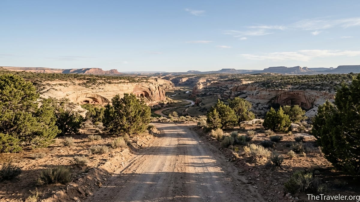
Roads, Access and Why Weather Matters More Than You Think
On a sunny day in late May, the drive across Cedar Mesa from Blanding to the House on Fire trailhead feels straightforward. Highway 95 is paved and in good condition, and the spur road into South Mule Canyon is usually manageable in a standard passenger car when it is dry. That leads some visitors to assume that every side road around Cedar Mesa is similar. A few days later, after a monsoon storm, a rental sedan can be mired to its axles in what looked like a harmless dirt lane.
Many of the roads that access trailheads and dispersed campsites are unpaved and built on clay-rich soils. Common examples include the network of roads along Comb Wash and Butler Wash, and side tracks leading out toward Arch Canyon or Texas Flat. On trip reports from spring and fall, high-clearance vehicles are often recommended, especially if you want to push beyond the main graded roads or if rain is in the forecast. A shower that barely dampens the pavement in Blanding can turn certain low-lying sections, particularly along washes, into slick, impassable gumbo.
Travelers also underestimate driving times because distances look short on the map. The cut through Comb Ridge on Highway 95 is only a few miles, but once you leave the highway for a back road like Butler Wash Road or an older alignment of Highway 95, speeds drop dramatically. A “quick detour” to check out a ruin or viewpoint can add an unexpected hour each way, particularly if you are easing your way over rock ledges or weaving around ruts. This matters if you are trying to link, for instance, a morning at Mule Canyon with an afternoon drive down to Valley of the Gods or Monument Valley.
The safest approach is to treat all unpaved side roads as conditional. Talk to staff at Kane Gulch Ranger Station or in Blanding about recent storms. Ask whether a standard rental car is reasonable for your planned routes or whether you should stick to the main graded roads and paved pullouts. If you arrive after heavy rain and see multiple local trucks parked at the highway while tracks disappear into a muddy road, that is a clear sign to rethink your plan for the day.
How Much Time You Really Need and What a Realistic Itinerary Looks Like
First-time visitors often try to fold Cedar Mesa into a whirlwind “Grand Circle” road trip that already includes Arches, Canyonlands, Monument Valley, and perhaps Zion or Bryce Canyon. On paper, a single day in Cedar Mesa seems enough to “see a few ruins.” On the ground, distances, rough roads and the desire to move slowly through canyons quickly eat up those hours. Many travelers who have been once say they wish they had dedicated at least two or three full days to Cedar Mesa alone.
A realistic short visit might look like this: Base in Blanding for two nights. On day one, drive about an hour to the South Mule Canyon trailhead, purchase your day-use pass, and spend a half-day hiking the easy canyon floor to House on Fire and perhaps one or two additional ruin sites beyond. After lunch back at your vehicle, continue on Highway 95 to the Butler Wash Interpretive Trail for a short, signed walk to cliff dwellings visible across the canyon, then loop back through town for dinner and supplies.
On day two, you could explore a different type of landscape by driving Highway 261 across the top of Cedar Mesa and descending the famously steep, unpaved Moki Dugway toward Valley of the Gods. The switchbacks are wide but exposed, and some visitors find them unnerving, especially in larger RVs. Others might prefer to stay atop the mesa and tackle a longer day hike into a less visited canyon such as Fish or Owl, which require better navigation skills and more time but reward you with quiet alcoves and complex archaeological sites. In either case, the day vanishes quickly once you factor in driving, permit stops and time lingering at sites.
Travelers with four or five days can add an overnight backpacking trip into Grand Gulch or Bullet Canyon, or spend more time exploring Comb Ridge from Butler Wash Road. Those trips reward careful planning: you need to secure an overnight permit, strategize water sources in canyons that only have intermittent pools, and carry appropriate bear- and rodent-resistant food storage. People who rush these decisions often end up shortening their trips or backtracking sooner than planned.
Respectful Visits to Archaeological Sites
Cedar Mesa’s ruins are why many travelers come, but they are also the landscape’s most fragile resource. Popular alcove dwellings such as House on Fire, the towers perched near the rim of Mule Canyon, and the cliff dwellings visible from the Butler Wash overlook have all seen a surge of visitation in recent years. Visitors sometimes arrive holding social-media photos that show people standing in doorways, sitting on walls or posing inches from petroglyph panels. Today, that kind of contact is explicitly discouraged and can be illegal.
On the ground, “visit with respect” means staying on existing paths or slickrock whenever possible to avoid new social trails and erosion. When you approach a ruin, it means stopping well back from walls and never entering rooms, even if you can see old boot prints. In many canyons you will notice pans of packed earth where people have walked for decades; the thin crust of soil around that pad can be biological soil crust, a living community of organisms that anchors sand and allows plants to grow. One careless step off the beaten path can erase decades of growth in seconds.
Artifacts require particular care. It is common to see pottery sherds, corncobs, grinding stones and other cultural materials scattered on the ground in alcoves and along benches. The law requires that you leave them exactly where they are, even if previous visitors have stacked them into piles. Do not pick them up for a closer look, rearrange them for photos or carry even a single piece away. Land managers and descendant communities use these small clues to understand and care for the sites; once removed, that context is gone forever.
Finally, many travelers underestimate the emotional weight of visiting a living cultural landscape. For Navajo, Hopi, Ute and Pueblo peoples, Cedar Mesa is not just a collection of photogenic ruins; it is an ancestral homeland and a place of ongoing spiritual significance. When you lower your voice in a canyon, skip a drone flight or choose not to publish GPS coordinates for a fragile site, you are not simply following rules. You are participating in a broader effort to keep this landscape intact for the communities who have ties to it that stretch back thousands of years.
Desert Conditions, Water and Seasonal Timing
Visitors accustomed to the amenities of Moab or Springdale are often surprised by how exposed Cedar Mesa feels. Elevations on the mesa top hover around 6,000 feet, which means spring nights can be near freezing even as daytime temperatures climb into the 70s Fahrenheit. By June, canyon bottoms can feel like ovens, with air temperatures easily in the 90s and radiant heat from rock walls boosting the apparent temperature even higher. Summer monsoon storms typically roll through from July into early fall, bringing lightning, sudden downpours and the risk of flash floods.
The combination of altitude, dry air and exposure makes water management critical. For a simple day hike in Mule Canyon, experienced hikers commonly carry at least three liters of water per person, more in hot weather. Deeper canyons such as Grand Gulch can have reliable pools and seeps, but these can vary seasonally, and some tanks turn silty or stagnant by late summer. Most backpackers carry a combination of water filters and chemical treatment and plan their camps around known sources rather than assuming they will find water in every side canyon.
Seasonality also shapes how crowded the area feels. March through May and late September through October are the busiest times, with pleasant temperatures and lower flash-flood risk than midsummer. That is when parking lots at South Mule Canyon or Kane Gulch can be close to full by mid-morning, and when you are most likely to encounter guided groups on the trail. Winter visits can be stunning, with low-angle light and patches of snow on the mesa, but short daylight hours and icy side roads require extra caution. Many repeat visitors say they wish they had skipped a hot July weekend and instead planned around the shoulder seasons, even if that meant cooler nights.
Finally, Cedar Mesa is dark. Light pollution is minimal, and on moonless nights the Milky Way can be vivid overhead. That darkness is a gift, but it can make navigation and camp setup difficult if you arrive late. Aim to reach unfamiliar trailheads and campsites in daylight, and do not count on cell phone flashlights alone. A headlamp with spare batteries, even for a simple evening walk along the rim, can make the difference between a calm night and a stressful search for your vehicle.
Camping, Lodging and Food: What Exists and What Does Not
Compared with national parks that have organized campgrounds and in-park lodges, Cedar Mesa offers a patchwork of options. On the mesa top, car camping is generally allowed on existing dispersed sites along certain BLM roads, often marked by flat, previously used clearings with rock fire rings. There are no hookups, no water spigots and usually no toilets, so you need to be fully self-contained. Managers ask visitors to use existing campsites instead of creating new ones, pack out all trash and use portable toilets or dig catholes far from water and archaeological sites where dispersal is still allowed.
There are also a few small developed campgrounds in the broader region, such as sites along Highway 95 closer to Natural Bridges National Monument or private campgrounds near Bluff and Blanding. These often provide vault toilets and picnic tables, sometimes potable water, and may charge a modest nightly fee. They can be a good compromise for travelers uncomfortable with completely primitive camping but still wanting to wake up close to Cedar Mesa’s trailheads.
If you prefer a hot shower and a proper bed, you will need to stay in a nearby town. Blanding, about 40 to 60 minutes from many Cedar Mesa trailheads, has basic motels, small locally owned inns and a few vacation rentals. Bluff, a bit farther for some sites but closer to Comb Ridge and Valley of the Gods, offers boutique lodges, casitas and a limited number of restaurants. Moab and Monticello sit more than an hour and a half away but have full-service supermarkets, outfitters and a wider range of dining options. What you will not find near Cedar Mesa itself are resort-style hotels, chain restaurants or 24-hour supermarkets.
Food logistics catch many travelers off guard. There are no grocery stores or gas stations on the mesa top. A reasonable strategy is to stock up in a larger town like Moab or Cortez, then top off fuel and grab last-minute items in Blanding before heading toward Highway 95 or 261. Carry more water and snacks in the car than you think you will need, and plan for lunches on the trail rather than assuming there will be a café near your hike. After a long day in the canyons, many visitors end up eating simple motel-room dinners or quick meals in small-town diners rather than elaborate restaurant outings.
The Takeaway
People who fall in love with Cedar Mesa tend to speak of it in quiet tones: as a place of layered sandstone and silence, where you can walk for hours with only canyon wrens and the wind for company. They also tend to admit that their first visit involved mistakes. Some arrived without understanding permit rules and had to change plans at the last minute. Others underestimated driving times on dirt roads or the impact of altitude and heat. A few did not yet grasp how fragile the archaeological sites were until they saw crumbling fingerprints in mud plaster and handprints on canyon walls.
If you take anything from the experiences of those repeat visitors, let it be this: Cedar Mesa rewards those who move slowly, plan ahead and err on the side of respect. Read up on permits and regulations before you come. Check weather and road conditions often, and be honest about the capabilities of your vehicle and your group. Give yourself enough days that you are not racing from ruin to ruin. Most of all, remember that you are a guest in a living cultural landscape. When you tread lightly, camp thoughtfully and leave what you find, you help ensure that the silence, the stars and the stories embedded in stone will still be there for whoever comes after you.
FAQ
Q1. Do I need a permit to day hike in Cedar Mesa canyons?
Yes. Most popular canyons on Cedar Mesa and nearby Comb Ridge require a paid day-use pass, typically purchased at trailhead fee stations or reserved in advance through official permitting systems.
Q2. Is a national parks pass valid for Cedar Mesa fees?
No. Standard public lands or national parks passes do not cover Cedar Mesa day-use or overnight backcountry fees. You must pay the specific BLM fees for this area.
Q3. Can I reach House on Fire in a regular rental car?
In dry conditions, most visitors reach the South Mule Canyon trailhead on a short dirt spur off Highway 95 in a standard car. After rain or snow, mud and ruts may make high clearance or four-wheel drive much safer.
Q4. When is the best time of year to visit Cedar Mesa?
Spring and fall are generally best, with cooler temperatures and fewer thunderstorms than midsummer. March to May and late September to October are popular windows for both day hikes and backpacking.
Q5. Are there developed campgrounds on Cedar Mesa?
On the mesa top itself, most camping is dispersed at existing primitive sites with no services. Developed campgrounds with toilets and defined sites are found in nearby areas and towns rather than on the core Cedar Mesa plateau.
Q6. How many days should I plan for a first visit?
Many travelers wish they had allowed at least two or three full days. That amount of time lets you do a marquee hike like Mule Canyon, explore a second canyon or overlook, and adjust for weather or road conditions.
Q7. Is cell phone service available around Cedar Mesa?
Coverage is spotty to nonexistent on much of the mesa and in the canyons. You may get limited reception along highways or near towns, but you should not rely on mobile service for navigation or emergencies.
Q8. Can I bring my dog on hikes in Cedar Mesa?
Leashed dogs are generally allowed on many Cedar Mesa trails, but you are responsible for keeping them away from archaeological sites, packing out waste and being prepared for hot, exposed conditions and lack of water.
Q9. How do I visit archaeological sites without causing damage?
Stay on existing paths, keep a physical distance from walls and doorways, never enter structures, and leave all artifacts exactly where you find them. Avoid touching rock art or leaning on masonry.
Q10. Are guided trips available, or do I have to go on my own?
Several regional outfitters and Indigenous-led guides offer day trips and backpacking itineraries in and around Bears Ears and Cedar Mesa. A guided outing can be a good option if you are new to desert travel or want deeper cultural context.