
Drive west from the small town of Blanding, Utah, and the pavement of State Route 95 climbs onto a broad, windswept table of sandstone called Cedar Mesa. At first glance it looks like typical high desert: scattered piñon and juniper, red rock canyons slashing toward the San Juan River, distant silhouettes of the Bears Ears buttes. What many travelers never realize is that this unassuming plateau holds one of the greatest concentrations of ancestral sites in the American Southwest, rivaling far more famous destinations yet receiving only a fraction of their visitors.
Get the latest updates straight to your inbox!
A Landscape Hiding Thousands of Stories
Cedar Mesa is a high plateau in southeastern Utah, carved by tributaries of the San Juan River into a maze of canyons such as Grand Gulch, Mule Canyon and Fish Canyon. Much of it now lies within Bears Ears National Monument, co-managed by federal agencies and a coalition of Native nations. Archaeologists have recorded thousands of sites here, from tiny granaries tucked into alcoves to multi-room cliff dwellings and rock art panels, and surveys suggest that only a small percentage of the landscape has been systematically inventoried.
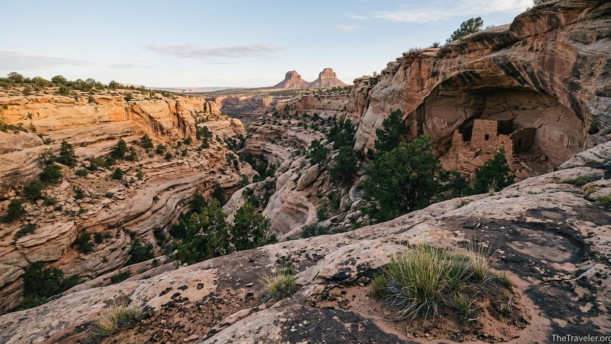
For today’s traveler, that density is hard to grasp until you step into one of the canyons. Hike just a mile up the South Fork of Mule Canyon from the trailhead off State Route 95 and you reach the famous House on Fire ruin, a cluster of ancestral Puebloan granaries built beneath a streaked sandstone overhang that glows orange when the morning sun hits it at the right angle. Keep walking another mile or two and more structures begin to appear: collapsed walls, pecked handholds up cliffs, small rooms hidden high in side alcoves. The effect is less like visiting a single “attraction” and more like walking through a continuous, open-air museum.
Unlike marquee parks such as Mesa Verde or Chaco Culture, Cedar Mesa’s archaeological record is spread across a largely roadless backcountry. Reaching a site like the Citadel, a dramatic ruin perched on a narrow fin of rock, or Moon House, an intricately plastered cliff dwelling on the mesa’s eastern edge, can involve driving graded dirt roads, following faint social trails and route-finding in unmarked slickrock. The effort required naturally limits crowds and keeps many places feeling genuinely remote, even in high season.
That remoteness is a large part of Cedar Mesa’s appeal. Standing in a quiet bend of Grand Gulch at dusk, with canyon wrens spiraling their song down the walls and a cluster of ancient structures silhouetted above you, it is easy to forget you are only an hour’s drive from modern services in Blanding or Bluff. Few archaeological landscapes in the Southwest offer this mix of intact sites, relative solitude and expansive desert scenery.
From Clovis Hunters to Pueblo Villages
The archaeological story of Cedar Mesa stretches back at least to the late Ice Age. On the mesa’s southeastern edge, the Lime Ridge Clovis site yielded characteristic stone spear points associated with some of the earliest widely recognized peoples in North America. Later, Archaic hunter-gatherers left rock art and campsites across the plateau, followed by Basketmaker communities who began cultivating maize and building pithouses along canyon rims and benches.
By the time of the Pueblo II and Pueblo III periods, roughly the 10th to 13th centuries, Cedar Mesa had become home to numerous farming villages. In Grand Gulch, sites like Junction Village sit atop promontories above reliable water sources, with roomblocks, kivas, middens and agricultural terraces all still visible. Elsewhere on the mesa, towers like those at the Cave Towers area of Mule Canyon may have served as lookouts, signaling points or ceremonial structures, their exact functions still debated among archaeologists.
One of the most evocative places to glimpse this late Puebloan era is Moon House, a compact but architecturally intricate cliff dwelling reached by a short, steep hike off a dirt spur road on the eastern side of Cedar Mesa. The site takes its modern name from a white crescent painted inside one of the rooms, but what captures most visitors’ attention is the complex arrangement of interlocking walls and tiny doorways. The interior still preserves original plaster and painted designs, which is why access is strictly controlled: only a limited number of day-use permits are issued, and visitors must follow a designated route and avoid entering the most fragile rooms.
By the late 1200s, most of these villages were abandoned, part of a broader depopulation of the northern San Juan region. Cedar Mesa appears to have seen people move away earlier than some neighboring areas, suggesting that the story is more complicated than a simple drought narrative. Later, Navajo and Ute peoples left their own marks in the form of rock art, historic camps and trail systems. Today’s Native nations emphasize that what archaeologists call “sites” are, for them, ancestral homes, ceremonial spaces and parts of an ongoing cultural landscape.
Why Cedar Mesa Stays Under the Radar
Given its archaeological richness, it can be surprising how few travelers have even heard of Cedar Mesa. One reason is that it lacks the formal infrastructure and marketing of big-name parks. There are no lodges tucked on canyon rims, no massive visitor centers with exhibition halls. The closest staffed contact point is the Kane Gulch Ranger Station on State Route 261, which typically operates seasonally and offers basic exhibits, permits and trip-planning help. Most visitors stay in motels or small inns in Blanding, Bluff or Monticello and drive into the mesa for day hikes or backpacking trips.
Another factor is Cedar Mesa’s focus on low-key, self-reliant recreation. You won’t find paved, accessible trails to cliff dwellings with interpretive rangers leading scheduled tours every hour. Instead, even the more popular hikes like South Mule Canyon, Procession Panel or Government Trail into Grand Gulch involve unpaved access roads, dirt trailheads with fee envelopes, and route-finding in sand and slickrock. That appeals to experienced desert hikers, but it can intimidate or inconvenience travelers who are used to the straightforward logistics of a place like Zion or Arches.
There is also a deliberate effort to avoid mass promotion. Tribal governments, land managers and local conservation groups have repeatedly cautioned that Cedar Mesa’s fragile alcove dwellings and rock art cannot withstand the same level of visitation that more robust stone ruins or open landscapes might tolerate. Management plans have prioritized caps on daily use in sensitive canyons, permit systems for the most vulnerable sites and education campaigns centered on visiting with respect rather than on attracting as many people as possible.
For travelers willing to do a bit of homework, this relative obscurity is a gift. On a weekday in April, you might find a dozen cars at the South Mule Canyon trailhead and encounter several groups around House on Fire. But wander into one of the lesser-known forks of Grand Gulch, or hike the rim to a remote overlook of Polly Mesa, and you can easily spend an entire day seeing more lizards than humans, even in peak season.
Signature Sites: From House on Fire to the Citadel
While part of Cedar Mesa’s magic lies in its unnamed alcoves and unpublicized locations, several well-known sites provide accessible windows into the area’s deep past. House on Fire is arguably the most photographed. The hike begins from a signed parking area off State Route 95. After paying the modest day-use fee at the self-service station, you follow a sandy wash and intermittent trail for roughly a mile to an alcove on the right-hand side. In the late morning, when reflected light bounces off the canyon floor, streaks in the sandstone ceiling flare orange and red above the stone granaries, creating the illusion of flames.
A few minutes east on the highway, the Mule Canyon Interpretive Site offers a different experience. Here, a short paved path loops around restored above-ground rooms surrounding a kiva, with interpretive signs explaining how ancestral Puebloans organized their domestic and ceremonial spaces. You can visit this roadside complex in 20 or 30 minutes, making it a good stop for families or travelers not ready for a full canyon hike but curious about the region’s history.
On Cedar Mesa’s eastern rim, Moon House requires more advance planning. Access is limited to a specific number of hikers per day, and permits must be reserved in advance through the federal permitting system. The rough access road often demands high-clearance vehicles, and the final approach includes navigating steep slickrock and ledges. Many travelers choose to hire a local guide based in Bluff or Blanding who can provide transportation, help with navigation and offer cultural context while ensuring that visit-with-respect guidelines are followed at the site.
For those seeking a deeper backcountry immersion, destinations like the Citadel or the canyons of Grand Gulch feel almost cinematic in their drama, though the reality on the ground is dusty, strenuous and very real. Reaching the Citadel typically involves hiking across open slickrock to the end of a narrow promontory, then crossing a neck of rock to a fin where a small cluster of masonry rooms clings to the cliff. There are no railings, no constructed steps, just airy exposure and sweeping views across Road Canyon and the surrounding mesas. In Grand Gulch, backpackers can spend several days traveling from one bend to the next, camping on designated durable surfaces, filtering scarce water and exploring side canyons that each hold their own clusters of dwellings and rock art.
How to Visit Responsibly Under Today’s Rules
Cedar Mesa’s status within Bears Ears National Monument means that regulations can evolve, and it is important to check current conditions and rules before visiting. As of 2026, day hiking in the canyons of Cedar Mesa and neighboring Comb Ridge requires a day-use pass, which can usually be purchased either online in advance or at fee stations located at trailheads and along key access roads. Overnight backpacking in canyons such as Grand Gulch or Bullet Canyon, and day hiking to Moon House, requires advance permits with limited quotas.
In practice, that means a traveler planning an April backpack in Grand Gulch might log on several weeks ahead to secure a multi-day permit covering their chosen entry and exit points. A couple staying in Bluff who only wants to visit House on Fire for a morning could purchase a day-hiking pass that covers several consecutive days, leave the pass displayed on their dashboard and be ready to hike after a quick stop at Kane Gulch Ranger Station for current water reports. Organized groups and commercial outfitters face additional requirements, including special recreation permits and group size limits.
Once on the ground, the rules are straightforward but strictly enforced. You are expected to stay on established trails or durable surfaces where they exist, avoid entering fragile rooms unless signage or a ranger explicitly indicates that entry is allowed, and never touch rock art or surface artifacts. Pottery sherds and stone flakes should be left exactly where they are found; gathering them into piles or “display rocks,” even with good intentions, disturbs the archaeological record. Camping is restricted in proximity to certain sites, and fires are often prohibited in canyon bottoms where wood is scarce and cultural resources are dense.
Given the scarcity of water and shade, self-reliance is essential. There are no services at most trailheads, and cell coverage is spotty to nonexistent across the mesa. Seasoned desert hikers routinely carry three to four liters of water per person for a moderate day hike in warm weather, plus extra stored in their vehicles. Simple, practical steps like starting early to avoid midday heat, bringing a paper map as backup to GPS apps, and letting someone know your itinerary can make the difference between an enjoyable day exploring Ancestral sites and a stressful rescue situation.
Partnering With Indigenous Voices and Local Stewards
One of the most compelling reasons Cedar Mesa stands out among archaeological landscapes is the way its management increasingly centers Indigenous perspectives. Bears Ears National Monument is co-managed in consultation with a coalition of tribes with ancestral ties to the region, including the Navajo Nation, Hopi, Ute Mountain Ute, Ute Indian Tribe and the Pueblo of Zuni. Recent resource management plans emphasize that sites on Cedar Mesa are not relics of a vanished culture but part of living traditions and ongoing spiritual practice.
Travelers can connect with this living dimension by seeking out Native-led tours and educational programs based in nearby communities. For example, guides from Navajo or Pueblo backgrounds may share stories about traditional uses of plants along the trail, explain how certain rock art motifs are understood within their communities, or simply articulate why some locations are not appropriate for photography or social media posts. While specific offerings change from season to season, choosing operators who clearly state their tribal affiliations and emphasize cultural respect helps support local economies and ensures that your visit aligns with community priorities.
Nonprofit groups also play a major role in caring for Cedar Mesa. Local organizations based in Bluff and Blanding have long worked to train volunteer site stewards, run small education centers and produce visit-with-respect materials that you may encounter at trailheads or in local hotels. Travelers might attend an evening talk in Bluff about pottery styles in Grand Gulch, or drop into a small heritage center to view exhibits curated in collaboration with tribal partners before heading out to hike.
Engaging with these resources deepens a trip beyond simple sightseeing. Understanding that a granary above your campsite once stored the corn harvest of a specific family, or that a handprint panel marks a place of emergence or transition in oral histories, can transform an anonymous ruin into a node in a much larger network of meaning. When enough visitors make that shift, Cedar Mesa becomes less an “undiscovered” destination to check off and more a shared responsibility.
Planning Your Trip: Seasons, Gateways and Practical Tips
Because Cedar Mesa sits at elevations around 6,000 feet, it experiences a wider range of temperatures than many travelers expect from “the desert.” Spring and fall are generally the most comfortable times to visit, with cool mornings, mild afternoons and higher chances of water in canyon pools. March and April can still bring snow or freezing nights on the mesa top, while October and early November often deliver crisp air and clear light ideal for photography. Summer afternoons frequently spike into the 90s Fahrenheit or higher, and monsoon storms from July into early September can turn dry washes into dangerous flash floods.
Most visitors base themselves in Blanding, Bluff or Monticello, all within roughly an hour’s drive of major trailheads. Blanding offers the widest range of basic motels, grocery stores and gas stations. Bluff has smaller inns and bed-and-breakfast options, plus a growing number of outfitters offering guided trips into Bears Ears. Monticello, to the north, appeals to travelers continuing on toward Canyonlands or Moab. Wild camping on the mesa is allowed in certain dispersed areas away from cultural sites and sensitive habitats, but you should check current regulations and practice rigorous Leave No Trace discipline, including packing out all waste.
Logistically, a typical Cedar Mesa day might look like this: after an early breakfast in Blanding, you drive west on State Route 95, stopping briefly at the Mule Canyon Interpretive Site to stretch your legs and read the exhibits. You continue a few minutes to the signed turn for South Mule Canyon, fill out a day-use envelope if needed and start hiking by 9 a.m. After visiting House on Fire and perhaps continuing farther up-canyon to other ruins, you return to the car in early afternoon, then detour up State Route 261 toward the Kane Gulch Ranger Station to ask about water levels in Grand Gulch or road conditions toward the Citadel trailhead.
With more time, travelers can link Cedar Mesa into a broader circuit along the Trail of the Ancients Scenic Byway, visiting Hovenweep National Monument’s towers on the Utah–Colorado border, Canyons of the Ancients Museum in Dolores, and the monumental cliff dwellings of Mesa Verde before circling back to the more subtle, dispersed sites on Cedar Mesa. Experiencing these places in sequence highlights what makes the mesa distinct: its relative lack of modern infrastructure, its emphasis on self-guided exploration and its sense of being a living cultural landscape rather than a single, contained ruin.
The Takeaway
Cedar Mesa will probably never be the next Zion or Arches, and that is part of its value. This plateau and its canyons harbor layer upon layer of human history, from the earliest hunter-gatherers to complex farming villages and later Native communities, all set within a starkly beautiful desert environment. Its most remarkable quality may be the way ancient structures still blend into living ecosystems: granaries tucked under alcoves that now shelter owls, stairways pecked into cliffs that bighorn sheep traverse, pottery sherds slowly weathering back into the sand.
For travelers, visiting Cedar Mesa is an invitation to slow down, plan carefully and accept a degree of uncertainty. Trails may be unmarked, water sources unreliable, and cell signals absent. In exchange, you gain something rare in the modern Southwest: the chance to encounter ancestral sites without turnstiles or parking lots intruding on the experience, and to do so in a way that respects both the past and the living communities connected to it.
If you decide to go, approach Cedar Mesa less as a hidden gem to be “discovered” and more as a place to be approached with humility. Obtain the necessary permits, learn from local and Indigenous voices, stay on durable paths, and resist the urge to geotag every alcove. In doing so, you help ensure that this underrated archaeological treasure remains intact for future generations of travelers and for the descendants of those who built their homes in its canyons long before tourism existed.
FAQ
Q1. Do I need a permit to hike on Cedar Mesa?
For most canyon hikes on Cedar Mesa you need a day-use pass, and overnight backpacking trips require advance permits with limited quotas, especially in Grand Gulch and for Moon House.
Q2. What is the best time of year to visit Cedar Mesa?
Spring and fall generally offer the most comfortable conditions, with cool mornings and mild afternoons; summers can be extremely hot and winter storms can make roads and trails icy or muddy.
Q3. Can I visit House on Fire without a guide?
Yes, House on Fire is reachable by a relatively short hike from a marked trailhead, but you still need a day-use pass and should be prepared for desert conditions and basic route-finding.
Q4. How difficult is the hike to Moon House?
The hike to Moon House is moderately strenuous, involving steep slickrock and short scrambles, and access is controlled by a limited-entry permit system that must be arranged in advance.
Q5. Are there services or campgrounds on Cedar Mesa itself?
Services are very limited on the mesa; there are a few primitive campsites and dispersed camping areas, but no full-service campgrounds, fuel stations or restaurants on top of the plateau.
Q6. Is Cedar Mesa suitable for families with children?
Families with outdoor experience often enjoy shorter, easier stops like the Mule Canyon Interpretive Site or partial hikes into South Mule Canyon, but close supervision is essential around ruins and cliff edges.
Q7. Can I touch or enter the ancient structures I find?
In most cases you should avoid entering rooms or touching walls, rock art or artifacts; many structures are fragile, and even light contact can contribute to long-term damage.
Q8. Do I need a high-clearance or four-wheel-drive vehicle?
Major highway access points are paved, but many spur roads to trailheads are unpaved and can become rough or impassable when wet, so high-clearance vehicles are strongly recommended for backroad access.
Q9. How can I learn more about the Indigenous perspective on Cedar Mesa?
Consider visiting local heritage centers, seeking out Native-led tours based in nearby towns, and reading or listening to materials produced by the tribal nations involved in co-managing Bears Ears.
Q10. Is it okay to share GPS coordinates or detailed directions online?
Land managers and local communities often discourage sharing precise locations of sensitive sites; posting general area information rather than exact coordinates helps protect fragile ruins and rock art from overuse.