


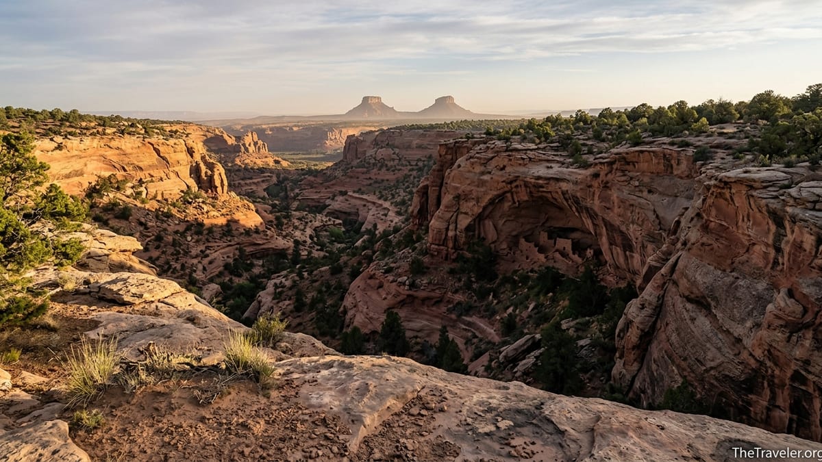
The first time I stood on the rim of Grand Gulch and looked across Cedar Mesa, the desert felt strangely crowded. Not with people, but with stories. Below me, a sandstone labyrinth of canyons and side drainages hid cliff dwellings in shadowed alcoves, pottery sherds resting in dust, handprints on varnished rock. Wind threaded through pinyon and juniper, sounding almost like distant voices. Exploring Cedar Mesa is not just a scenic hike through southeast Utah. It is a step into thousands of years of history, and a test of how respectfully we can move through a living cultural landscape that still matters deeply to the people whose ancestors built it.
Get the latest updates straight to your inbox!
A High Desert Plateau Steeped in Deep Time
Cedar Mesa sits on the southern edge of Bears Ears National Monument in southeastern Utah, a broad sandstone plateau carved into a lacework of canyons that drain toward the San Juan River. Rising above it to the north are the twin buttes known as the Bears Ears, while to the south the land breaks dramatically toward Monument Valley and the Valley of the Gods. The mesa itself averages about 6,000 feet in elevation, so the air feels thinner and cooler than the low desert, especially in spring and fall.
The human story here is staggering in its scale. Archaeologists estimate that ancestral Puebloan peoples and their predecessors began using this region at least 2,000 to 2,500 years ago, building pithouses and later multi-room masonry dwellings tucked into alcoves. Walk almost any canyon on Cedar Mesa and you see evidence of their lives: the T-shaped doorways of Pueblo III period cliff dwellings, low field-house foundations near former corn plots, and granaries sealed high in vertical walls that once protected harvests from rodents and weather.
Today Cedar Mesa is managed primarily by the Bureau of Land Management as part of Bears Ears National Monument, in close collaboration with the Bears Ears Commission, which represents five Native nations with ancestral ties to this land. That co-management is not an abstract policy line. On the ground, it shapes how visitors are asked to move through the landscape, what can be shared on social media, and why some sites are deliberately not signed or widely publicized. You are not simply touring ruins. You are entering a place that many modern Pueblo, Diné, and Ute people view as home and as a ceremonial landscape.
That sense of deep time changes how simple details strike you. The same Cedar Mesa sandstone that forms the sheer canyon walls also supplied blocks for ancient dwellings and grinding surfaces for manos and metates. The faint footpaths you follow to reach an alcove may trace routes people used for generations. Even the silence feels layered, as if it holds the echoes of millennia of footsteps and voices.
Getting There: Remote Roads and First Impressions
Reaching Cedar Mesa is part of the adventure and a reminder of its remoteness. Most travelers arrive via U.S. Highway 191, then branch onto Utah State Route 95 or 261, connecting small gateway towns like Blanding, Bluff, and Mexican Hat. From the south, Route 261 climbs from the Valley of the Gods up the famous Moki Dugway, an unpaved series of steep, exposed switchbacks that gain about 1,200 feet in just a few miles. In dry conditions the Moki Dugway is passable in a standard vehicle with good tires, but it can feel hair-raising and is not recommended for large RVs or trailers.
Once on top of the mesa, the character of the drive changes. The world opens into a high, rolling plateau of sage, pinyon, and juniper, cut abruptly by canyon rims you may not see until you are almost upon them. Side roads, many of them graded dirt, fan out toward major trailheads like Kane Gulch, Government Trail, Bullet Canyon, Fish and Owl Canyons, and various access points for Grand Gulch. In dry weather, most of these are manageable in a passenger car if taken slowly, but after heavy rain or spring snowmelt, ruts and mud can quickly demand high clearance and sometimes four-wheel drive.
Because Cedar Mesa has no gas stations, restaurants, or lodging on the plateau itself, your practical base will be in the surrounding towns. Many travelers stock up on groceries and fuel in Blanding, then pick up regional information at the Bears Ears Education Center in Bluff before heading up to the mesa. Spending a night in Bluff or Mexican Hat on either end of your trip makes it easier to hit the trail early and to avoid driving the Moki Dugway or remote dirt roads in the dark.
Your first true impression of Cedar Mesa usually comes at a canyon rim. Even at popular access points like Kane Gulch Ranger Station, the landscape feels huge and oddly quiet. Look carefully across any broad side canyon: tiny dark rectangles may resolve into windows of a cliff dwelling, or you may spot a line of granaries blending into the rock. That combination of vastness and fine detail sets the tone for everything that follows.
Permits, Passes, and Respectful Access
Because Cedar Mesa contains one of the densest concentrations of archaeological sites in North America, access is carefully managed. Before you lace up your boots, it is essential to understand the permit system. Day hiking in Cedar Mesa and nearby Comb Ridge generally requires a day hiking pass, while backpacking in the canyons and certain sensitive sites like Moon House need advance permits with strict quotas and entry dates.
Day use passes are typically priced on a per-person basis, with options for a single day, a seven-day span, or an annual pass that covers multiple visits. As of this writing, expect the day rate per person to be in the single-digit dollar range and an annual hangtag per vehicle to be on the order of tens of dollars rather than hundreds. You can usually purchase these passes online ahead of time through the federal reservation portal or at self-serve fee stations at major trailheads with cash or check. The small fee goes toward managing trails, repairing impacts, and funding rangers who spend much of their time educating visitors on how to reduce damage.
Overnight backpacking permits in Grand Gulch and its tributaries are limited to a fixed number of people per trailhead per day, often around 20, to reduce crowding at camps and protect fragile sites. These permits are booked in advance through the same federal system, and popular spring and fall weekends can fill quickly. The process feels more like obtaining a backcountry permit for a major national park than a spur-of-the-moment BLM hike, which surprises some people accustomed to more open access on public lands.
Moon House, one of the most renowned cliff dwellings on Cedar Mesa, has its own separate day-use permit with a strict cap on visitor numbers each day. Permits open for reservations a few months ahead and regularly sell out in high season. That can be frustrating when you are planning a once-in-a-lifetime visit, but the alternative would likely be irreversible damage to a fragile multi-room dwelling, including rare interior plaster and pictographs. Planning early and being flexible with your dates is the best strategy.
Equally important is the concept many local stewards call "Visit with Respect." This ethic goes beyond the usual Leave No Trace principles. It means never entering dwellings or climbing on walls, even if there are no signs or ropes; leaving pottery, corn cobs, and tools exactly where they lie; avoiding posting precise GPS coordinates for sensitive sites online; and giving living Native communities room to shape how their history is shared. On a practical level, that may look like taking photos from a respectful distance, lowering your voice near sites, and choosing a campsite that is clearly away from any cultural features, even if it takes a bit more walking.
Hiking Through a Living Museum
Almost every trail on Cedar Mesa feels like a walk through an open-air museum, but a few routes have become classic introductions. The Kane Gulch to Junction Ruin day hike is a common first trip, leading about four miles down a broad canyon to an impressive cliff dwelling tucked beneath a sweeping alcove. The hike involves walking in sandy wash bottoms, weaving through cottonwood groves, and occasionally scrambling over boulders, but it is well within the abilities of moderately fit hikers. Along the way you may spot smaller granaries and rock art panels that hint at how densely this canyon was once inhabited.
For a deeper immersion, backpackers often choose multi-day trips through Grand Gulch, entering via Government Trail, Bullet Canyon, or Collins Canyon and weaving down-canyon among towering walls and shaded side alcoves. Camps are generally on sandy benches above the wash, and water sources shift by season. In wet springs, seeps and pools may be regular; in the hotter months, hikers may plan sections carefully between known water holes. Every bend seems to reveal something: a kiva depression in the canyon floor, pecked petroglyphs of bighorn sheep, or a line of handprints fading into darkness under a soot-stained ceiling.
Moon House offers a different kind of experience. After a drive across the mesa on a dirt track, you descend into McCloyd Canyon on a sometimes steep, rugged trail before traversing along the wall to reach the main dwelling. A BLM sign near the site usually explains the rules: groups often wait their turn to enter certain viewing zones, and interior rooms may be off-limits entirely. The reward is a remarkably intact multi-room structure with thick masonry walls, original plaster, and a distinctive moon-like pictograph that gave the site its name. Standing there, you feel acutely aware that you are peering into someone else’s home across a gulf of centuries.
Other canyons, like Fish and Owl, Slickhorn, and Mule Canyon, offer combinations of short day hikes and more committing backpacking routes. Some feature prominent sites like House on Fire, a photogenic alcove ruin whose sandstone ceiling glows dramatically in angled morning light. In recent years, heavy visitation and social media popularity have made House on Fire a symbol of the challenges of balancing access and preservation. Arriving early, stepping carefully to avoid fragile soil, and accepting a more contemplative visit rather than a quick photo stop all help reduce your footprint.
Seasons, Conditions, and Staying Safe
Cedar Mesa’s apparent stillness can be deceptive. This is a high desert plateau with real weather and real consequences for anyone who underestimates it. Spring and fall are the prime seasons, with daytime highs usually in the pleasant range and cool nights ideal for sleeping under the stars. In March and April, expect chilly mornings, lingering snow patches on north-facing slopes, and muddy roads after storms. By late May and June, heat settles in, canyon bottoms can feel oven-like in mid-afternoon, and unprepared hikers run real risks of dehydration and heat exhaustion.
Summer monsoon season, often from July into early September, adds another layer of complexity. Thunderstorms can build quickly over the Abajo Mountains to the north, then drift toward Cedar Mesa, dropping intense sheets of rain that turn dry washes into flash floods. A canyon that was a pleasant walk in the morning can become dangerous by afternoon. When the forecast shows monsoon moisture, many experienced visitors plan shorter day hikes near escape routes, avoid narrow slots, and keep a constant eye on the sky. Being willing to cancel or change plans based on conditions is part of traveling responsibly here.
Winter on Cedar Mesa can be surprisingly cold and quiet. Snow dusts the mesa top and sometimes lingers in shaded canyons, creating a stark contrast with the red rock. Some dirt roads become slick or impassable, and nights routinely drop well below freezing. For well-equipped hikers who are comfortable with winter camping, the payoff is solitude and the chance to see familiar formations under an entirely different light, but this is not a season for improvisation. A simple mechanical issue or getting stuck in mud miles from the highway can quickly escalate in subfreezing temperatures.
Whatever the season, basic safety practices matter. Water is scarce and often unfiltered from seeps or cattle troughs, so most backpackers carry a combination of a pump filter and chemical backup, and start with at least three to four liters per person for a day hike, more in hot weather. Cell service is patchy at best, often nonexistent once you drop into canyons. Many visitors now carry a satellite messenger or personal locator beacon, which can be a lifesaver in the event of a twisted ankle miles from the nearest trailhead. Leaving a detailed itinerary with someone who will notice if you are late is as important here as it is in any remote mountain range.
Gateway Towns, Logistics, and Real-World Costs
Although Cedar Mesa itself feels far removed from modern infrastructure, the small towns that ring it play a big role in how you experience the region. Blanding, about an hour’s drive from major trailheads, offers grocery stores, gas stations, and basic outdoor supplies, making it a practical place to stock up before you head to the mesa. Bluff, to the southeast, has a growing number of small inns and motels, cafes, and the Bears Ears Education Center, which serves as an unofficial visitor hub with maps, interpretive displays, and up-to-date information on conditions and closures.
Expect lodging prices in these towns to fluctuate with season and demand, generally ranging from budget motel rooms to midrange boutique stays. In shoulder seasons like March or November, you may find simple motel rooms at rates that feel modest compared to national park gateway towns, while during peak spring break weeks or long fall weekends, prices can climb significantly and vacancy becomes scarce. Booking ahead is wise if you do not plan to camp on the mesa.
On Cedar Mesa itself, most visitors either camp in designated BLM campgrounds or use dispersed roadside campsites along established dirt tracks. Fees at developed campgrounds, where they exist, tend to be minimal, similar to modest BLM sites elsewhere in the Southwest. Dispersed camping usually requires no nightly fee beyond your day or overnight permit, but it comes with strict expectations: use existing sites rather than creating new clearings, pack out all trash and human waste where required, and avoid camping within sight of archaeological sites or water sources. With increased visitation in recent years, rangers are more frequently closing and rehabilitating user-created campsites that have damaged fragile soils or vegetation.
Food and fuel logistics are straightforward if you treat Cedar Mesa like a remote backcountry destination rather than a roadside attraction. Fill your tank before driving up the mesa, carry extra drinking water in your vehicle, and pack enough meals and snacks for one or two extra days beyond your planned itinerary. For example, many backpackers heading into Grand Gulch shop for dehydrated meals, tortillas, and trail snacks in Blanding, then grab a hearty dinner and last-minute coffee in Bluff the night before their permit start date, knowing they will not see a restaurant again until they emerge dusty and hungry several days later.
Cultural Context and Traveling with Humility
However distant Cedar Mesa may feel from urban life, it is closely connected to living communities. For many Navajo and Pueblo people, these canyons are not just historic sites but part of their ongoing cultural and spiritual landscape. Petroglyphs and pictographs are not anonymous decorations; they can represent stories, clan symbols, or ceremonial records with meanings that are not meant to be decoded by casual visitors. Recognizing that you are a guest is one of the most important shifts you can make before setting foot in the canyons.
One concrete way to travel more thoughtfully is to begin your visit with Indigenous-led or locally grounded interpretation. That might mean attending a talk at the Bears Ears Education Center in Bluff, seeking out writing by Native authors about Bears Ears, or supporting guide services and businesses that employ people from nearby communities. While much of Cedar Mesa hiking is self-guided, a half-day cultural tour elsewhere in the region can dramatically reframe how you see even unmarked sites, transforming a scatter of sherds into evidence of sophisticated trade routes and seasonal migrations.
Another is to check your impulse to collect or share. In practice, that means leaving even the smallest potsherd where it lies instead of placing it on a "display rock" for a better photo, resisting the urge to scratch your initials in canyon walls, and being careful about how precisely you geotag images on social media. Locals have seen how a single viral post can flood a once-obscure alcove with visitors in a season, erasing the very sense of discovery that drew people there in the first place and accelerating wear on fragile plaster, rock art, and soil.
Finally, traveling with humility means accepting limits. Some remarkable places on Cedar Mesa are not marked on signs or highlighted in brochures, and there are good reasons for that. If a ranger suggests that a particular site is already overwhelmed and recommends a less fragile alternative, say yes. If a trailhead kiosk notes closures or asks you to avoid certain alcoves because of nesting raptors or ongoing tribal consultations, see that not as a restriction but as a basic act of respect toward both wildlife and human neighbors whose ties to this landscape run far deeper than any visitor’s.
The Takeaway
Exploring Cedar Mesa truly does feel like stepping into thousands of years of history, but it is not a history preserved under glass. It is scattered across canyon floors and alcove ledges, etched into sandstone and embedded in living memory. The same paths that hikers follow today once carried people between fields and homes, between kivas and water sources. Every decision you make on the mesa, from how you park your car to where you place your feet near a crumbling wall, becomes part of that ongoing story.
If you come prepared for remote conditions, take the time to secure the right permits, and approach each site with curiosity tempered by restraint, Cedar Mesa rewards you with rare depth. Morning light on desert varnish, ravens circling above a ruin, the quiet of a canyon night broken only by wind and the distant drip of water in a seep: these are the gifts the mesa still offers. Traveling thoughtfully helps ensure they remain available to the people whose ancestors built this place and to future visitors who are willing to meet it on its own terms.
In the end, the most meaningful souvenir you can carry away from Cedar Mesa is not a photograph of a famous ruin but a changed sense of time. When you have walked among dwellings that predate your home culture by centuries and seen how easily a misstep can erase their traces, the modern world’s rush feels different. The mesa keeps its own, much older pace. The best way to honor that is to slow down, listen carefully, and leave as light a mark as possible.
FAQ
Q1. Do I need a permit to hike on Cedar Mesa?
Yes. Most day hikes on Cedar Mesa and nearby Comb Ridge require a day hiking pass, and overnight backpacking trips need advance permits with limited daily quotas at each trailhead.
Q2. What is the best season to visit Cedar Mesa?
Spring and fall are generally best, with cooler temperatures and more reliable water in canyons. Summer can be extremely hot with flash-flood risk, and winter brings snow, ice, and cold nights.
Q3. Can I camp anywhere on Cedar Mesa?
You can camp in designated BLM campgrounds and at certain dispersed roadside sites, and in canyon bottoms on overnight permits. Always use existing campsites, follow fire restrictions, and avoid camping near archaeological sites.
Q4. How physically demanding are Cedar Mesa hikes?
Day hikes range from moderate to strenuous, often involving route-finding, sandy washes, and steep entry and exit routes. Backpacking trips through Grand Gulch and similar canyons require solid fitness, comfort with rough terrain, and the ability to carry sufficient water.
Q5. Is it allowed to enter cliff dwellings or touch artifacts?
No. Visitors are asked to stay out of dwellings, avoid climbing on walls, and never touch or move artifacts such as pottery sherds, corn cobs, or stone tools. Disturbance can cause irreversible damage and is often illegal.
Q6. What should I do if I find a site that is not marked on maps?
Enjoy it quietly from a respectful distance, do not share its exact location online, and report significant finds to land managers if appropriate. Leaving such places unpublicized helps protect them from heavy visitation and vandalism.
Q7. Are there services like gas, food, or water on Cedar Mesa?
No. There are no gas stations, restaurants, or potable water sources on the mesa itself. You should fill up on fuel, buy groceries, and top off water in nearby towns like Blanding or Bluff before heading out.
Q8. How can I learn more about the Indigenous history of Cedar Mesa?
Start at the Bears Ears Education Center in Bluff, read materials produced by Native nations connected to Bears Ears, and consider joining Indigenous-led or locally grounded interpretive programs elsewhere in the region.
Q9. Is Cedar Mesa suitable for families with children?
Yes, for prepared families. Shorter canyon walks and rim viewpoints can be rewarding for kids, but parents must closely supervise children near cliffs, ruins, and fragile soils, and carry plenty of water and sun protection.
Q10. Do I need four-wheel drive to reach Cedar Mesa trailheads?
In dry conditions many main trailheads are accessible in a standard vehicle with care, but conditions change quickly. After storms, some roads become rough or muddy enough that high clearance or four-wheel drive is strongly recommended.