


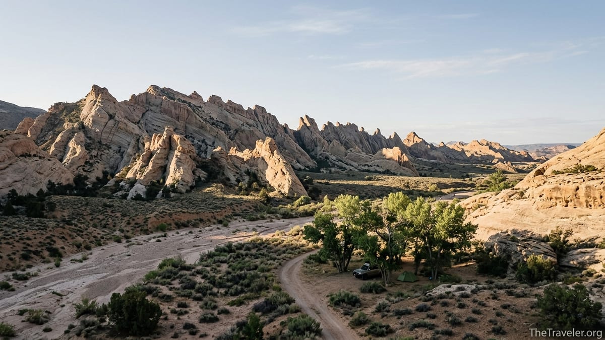
Comb Ridge rises like a stone wave out of the high desert of southeast Utah, a serrated wall of sandstone hiding rock art, cliff dwellings and sinuous canyons. It looks simple enough on a map: a single monocline running north to south between Blanding and Monument Valley. In reality, it is one of the most complex, regulated and misunderstood corners of Bears Ears National Monument. Before you turn down a dirt road toward Butler Wash or Comb Wash, there are things most travelers do not know but absolutely should.
Get the latest updates straight to your inbox!
Comb Ridge Is Part Of Bears Ears, Not A Free-For-All Backcountry
Many visitors still think of Comb Ridge as an isolated backcountry playground, but it now sits firmly inside Bears Ears National Monument, co-managed primarily by the Bureau of Land Management and the U.S. Forest Service. That change, formalized in 2016 and reaffirmed in 2021, matters more than most people realize. It shapes everything from where you can camp to how many people are allowed into certain canyons each day. What looks like open desert when you drive in from Bluff or Blanding is, in fact, one of the most heavily watched cultural landscapes in the Southwest, dotted with archaeological sites that local tribes consider living history rather than ruins.
The monument designation has brought more visitors, more social media attention, and stricter rules. Friends of Cedar Mesa and other local groups have documented steady increases in use across Cedar Mesa and Comb Ridge since the mid-2010s, enough that the BLM now speaks openly about crowding and resource damage in its planning documents. On the ground, that means you may find new informational signs, closed spur tracks, and more rangers checking permits than you might expect in what looks like remote country. Treat Comb Ridge less like an unregulated off-grid zone and more like you would a national park backcountry area that depends on your restraint.
For trip planning, it helps to think of Comb Ridge in zones. The eastern side is drained by Butler Wash, a network of canyons that hold some of the most famous rock art panels in the region. The western side drops steeply into Comb Wash, where a dirt road parallels the cliffs for miles, skirting cottonwood groves and sandy wash bottoms. Each side has different access roads, vehicle requirements and camping realities, which can surprise visitors who assume that a single ridgeline means a single experience.
You Probably Need A Day Hiking Pass, Even For Short Outings
One of the biggest surprises for first-time visitors is that much of Comb Ridge is no longer a “show up and wander” destination. The BLM’s current guidance for Bears Ears makes clear that day hiking in Cedar Mesa and Comb Ridge requires a day hiking pass in most canyons. As of mid‑2026, independent guide sites summarizing the rules describe fees in the range of a few dollars per person per day, with the option to buy a slightly more expensive weekly pass if you are staying longer in the region. Passes are typically obtained through the Cedar Mesa permit system, either online in advance or, for some areas, in person at local ranger stations when they are open.
The practical consequence is that you cannot assume that pulling off Butler Wash Road and dropping into the nearest side canyon is legal, even if there is a well-worn social trail. For example, hikers heading to the Procession Panel on the east side of Comb Ridge often park just off the graded county road and follow a path across open slickrock to a large petroglyph panel. It feels casual and immediate, but you are likely in an area covered by the permit system. The same applies to the Wolfman Panel farther south along Butler Wash, accessed by a short but steep trail from a spur road. Even if the hike is only an hour or two, the expectation is that you have a valid pass in your vehicle and on your person.
Enforcement can be sporadic, but fines do happen, and more importantly, permits are one of the few tools managers have to keep daily numbers low in fragile canyons. There is also a philosophical dimension: the fee is partially an education tool. At permit pickup, rangers and staff routinely emphasize “Visit with Respect” principles, including not touching rock art, staying off walls and mounds around dwellings, and avoiding posting exact locations on social media. If you are used to wandering BLM land in Utah without paperwork, this may feel like a mental shift, but at Comb Ridge it is now the norm rather than the exception.
Road Conditions Are Trickier Than They Look On A Map
Many travelers discover only after arrival that the roads along Comb Ridge are not created equal. On the east side, San Juan County Road 230, often referred to as Butler Wash Road, runs roughly parallel to the ridge between Highway 95 in the north and Highway 163 in the south. On most maps, it is a single pale line, but on the ground its character changes with every storm. Sections may be well-graded and passable for sedans in dry weather, followed by stretches of deep sand, eroded ledges or clay that turns to glue in a summer monsoon. Off‑road mapping services describe it as a mixed‑difficulty route, generally suited to high‑clearance vehicles, with 4x4 strongly recommended beyond the easiest segments.
The western side, Comb Wash Road, is another dirt route that threads along the base of the cliffs. This road is popular with campers seeking free dispersed sites under cottonwoods. It too can lull you into a false sense of security. The first few kilometers from Highway 95 are often relatively smooth, with visible fire rings and other campers in SUVs or small RVs. Deeper in, wash crossings become more chewed up, and heavy rain can strand vehicles in mud or on the wrong side of a flash flood. Recovery services out of Blanding or Bluff can cost several hundred dollars for a single pull, especially if winching is required.
From a planning perspective, you should not assume that the road you used to enter will be in the same condition when you leave. Summer monsoon storms can dump rain upstream that never touches your camp but sends a wall of water down Butler Wash or Comb Wash, undercutting banks or carving ruts overnight. In shoulder seasons, snowmelt and freeze‑thaw cycles create hidden potholes and greasy slopes on the ascent to the ridge from Highway 95. Before committing your rental SUV or camper van, it is wise to ask in Bluff, Blanding or at a local outdoor shop about current conditions and to carry enough water and food to wait out a storm if needed.
Navigation is another subtle challenge. Cell coverage around Comb Ridge is spotty to non‑existent, even within a short drive of U.S. highways. Some spur roads that show on older GPS basemaps have been closed or rehabilitated as part of the monument’s management, so expecting your phone to guide you to a rock art site can end with you facing a “Route Closed” sign and needing to backtrack many kilometers on rough track. Paper maps from local visitor centers, combined with downloaded offline mapping apps, provide a more reliable system than a single turn‑by‑turn app dependent on data.
Cultural Sites Are Everywhere, And You Are Walking Through Living History
What most people do not realize until they are standing at the base of the ridge is just how dense the archaeology is at Comb Ridge. Butler Wash alone holds dozens of documented cliff dwellings and granaries, many visible from the canyon floor, others tucked high on ledges. Famous sites like Procession Panel and Wolfman Panel are only the most visible examples of a cultural landscape that stretches across Cedar Mesa and beyond. Archaeologists estimate that the greater Bears Ears region holds tens of thousands of individual sites, ranging from single-room structures to multi‑room pueblos and kivas.
For Navajo, Hopi, Ute and Pueblo peoples, these are not simply remnants of a vanished culture. They are part of an ongoing story, with spiritual and familial connections that continue to the present day. Local tribal representatives have repeatedly asked visitors to treat these places as they would someone’s home or community center, not as abandoned ruins or adventure backdrops. In practice, that means avoiding entering rooms or climbing on walls, even if other visitors’ footprints suggest it is common. The sandstone and mortar are often far more fragile than they look; one careless boot edge can knock loose a stone that has held for centuries.
Vandalism and artifact theft remain real issues. Bears Ears management documents and local advocacy groups have reported incidents of petroglyph panels scratched over with initials, bullets scars, and even attempts to saw panels off the rock. In response, agencies have begun to close or quietly de‑emphasize some sensitive locations. As a visitor, you can help keep sites open by following a few simple habits: keep at least a body‑length away from walls with plaster or rock art; never touch rock art, which can be damaged by the oils on your skin; and leave any pottery shards, stone tools or corncobs exactly where you find them. Photograph them in place if you like, but think carefully before sharing detailed geotagged images that can drive crowds to small, fragile alcoves.
It can also be disorienting to realize that not all sites are marked. You may hike to a well-known ruin with an obvious trail and interpretive signs in the morning, then wander near camp in the afternoon and discover a low wall or midden mound under your feet. Just because there is no sign does not mean the location is unimportant. When in doubt, stay on durable surfaces like slickrock and established paths, avoid walking on cryptobiotic soil crusts, and give any stone alignments or stacked rocks a respectful distance.
Camping Rules Are Tightening, Especially Near The Ridge
For years, Comb Wash on the west side of the ridge was a classic example of free BLM dispersed camping: pull off the dirt road into a flat spot near cottonwoods, set up a tent or park your van, and enjoy the night. That is still broadly true in some stretches, and you will see it reflected in recent user reviews of the area describing open, no‑fee sites with basic stone fire rings and the occasional picnic table. However, what many travelers do not realize is that land managers are steadily tightening camping regulations around Comb Ridge to protect both cultural resources and vegetation.
Recent planning documents for Bears Ears outline proposals that include closing portions of the Comb Ridge area to dispersed camping and formalizing designated sites in others. In practice, visitors may encounter new signs limiting camping to established spots, as well as length‑of‑stay rules, commonly around 14 days on BLM land. Fire restrictions are also frequent in this dry landscape; during high‑risk periods, campfires may be prohibited, even in existing rings. Bringing a portable stove and being prepared to forgo a campfire altogether is the most responsible approach.
Perhaps the most important, and least understood, camping issue is human waste. The combination of shallow soils, high visitation and sensitive cultural sites makes burying waste in cat holes a poor option in many parts of Comb Ridge. Rangers and local organizations increasingly encourage or require visitors to pack out their waste using sealable bags or portable toilet systems. It may feel extreme if you are used to traditional backcountry practices, but in narrow canyons and popular wash bottoms, it is often the only way to prevent contamination of seeps and the unpleasant reality of stumbling across others’ improvised latrines.
Finally, not every open patch of ground is public. Pockets of state and private land are interspersed along access roads, especially closer to Bluff and Highway 163. Trespassing, even accidentally, can strain relations with local residents who already carry a heavy share of the impacts from increased visitation. When in doubt, use updated maps that clearly differentiate land ownership, and if a spur road passes a ranch gate, water tank or home, assume you should keep driving unless you are certain the land is public and open to camping.
Safety Hazards Go Beyond Heat And Dehydration
Comb Ridge looks tame from the highway: a series of tan and red fins rolling toward the horizon. Up close, it is a tangle of steep slickrock, slots, pour‑offs and loose talus that has humbled many confident hikers. Heat and dehydration are the obvious hazards. Summer temperatures routinely climb high enough that even early morning hikes can feel brutal, and there is very little natural shade once you leave the bottoms of Butler Wash or Comb Wash. Water sources are unreliable. A spring that was flowing last year may be dry this year, and surface pools in potholes can be polluted by livestock or wildlife. Most experienced visitors carry several liters of water per person for even modest day hikes and keep extra jugs in vehicles at camp.
Less obvious dangers catch many travelers off guard. The sandstone of the ridge can be exceedingly grippy when dry, encouraging steep friction climbs and scrambles, but it becomes slick as ice when wet or dusted with fine sand. Short drops that look casual from below can be extremely exposed once you are committed, especially with a daypack that shifts your balance. Rescue operations in this part of Utah are limited, slow and expensive, often involving volunteer teams who must drive long distances on rough roads before they can even begin a search. A twisted ankle on a high bench, with no cell coverage, can become an overnight ordeal if your group is not prepared.
Flash floods are another underappreciated risk. Butler Wash and its side canyons are designed by nature to concentrate water. A storm cell many kilometers away on Cedar Mesa can send a wall of churning mud downcanyon with little warning where you are hiking. Signs of recent floods include fresh scours in sand, tangled driftwood around shrubs, and undercut banks. If forecasts hint at monsoon storms, a hike that requires walking long stretches in a narrow canyon bottom or crossing the wash repeatedly is best postponed. Travelers in vehicles should be equally cautious about crossing flowing water; even a shallow flood can roll a high‑clearance truck off its wheels if it loses traction in soft sediment.
Then there is simple remoteness. Distances that look short on a regional map feel long when you realize that the nearest full‑service hospital is hours away and that the gas station where you last topped up may be the only one open on a Sunday in a small town. It is prudent to carry a basic first‑aid kit, extra food, a paper map, and, if possible, a satellite messenger that can send an SOS if something goes badly wrong. None of this is meant to discourage exploration; rather, it is to align expectations. Comb Ridge is not a roadside attraction, even when you can see it from your car window. It is true backcountry, just a few minutes off the pavement.
Local Communities And Tribal Voices Deserve A Place In Your Itinerary
Another aspect many travelers overlook is that Comb Ridge does not exist in a vacuum. The ridge is framed by communities like Bluff, Blanding and the Navajo Nation, along with tribal organizations that have worked for years to protect the region. Spending time and money in these communities is more than a convenience; it is part of traveling responsibly in a contested, culturally rich landscape. Visitor centers and cultural institutions in the area often provide context you will never get from a GPS track or social media post, including Native perspectives on why certain sites are sacred and how visitation feels on the ground.
Local outfitters and guides, including Indigenous‑owned businesses, also play a crucial role. Hiring a guide for a day in Butler Wash or a longer trip across Cedar Mesa not only increases your safety and route options but supports people whose families have deep ties to the land. Guides can point out features you might miss on your own, such as subtle field systems, shrines or plant uses, and can explain why a seemingly anonymous alcove holds meaning. In an era when many travelers rely solely on downloadable GPX files, the value of local human knowledge is easy to underestimate.
Respect for local communities extends to everyday decisions. The sudden popularity of overnighted camper vans and rooftop tents has strained basic services in small towns, from trash disposal to public restrooms. Choosing to stay some nights in locally owned lodges, eating at family‑run cafes, and asking staff about current issues or concerns can shift your mindset from “using” the region as a backdrop to being a guest. Small gestures, such as not blocking store parking lots with large rigs or asking permission before photographing people or homes, signal that you see the area as more than an adventure playground.
The Takeaway
Comb Ridge rewards effort with some of the most powerful desert experiences in the American Southwest: mornings among cottonwoods in Comb Wash, afternoons tracing faint paths to rock art that has weathered centuries, evenings watching alpenglow sweep along a serrated skyline. Yet the very qualities that make it unforgettable also make it vulnerable. Its archaeological sites are both numerous and fragile. Its canyons can turn dangerous in minutes with a stray storm. Its roads and campsites are under pressure from surging interest in Bears Ears as a whole.
Arriving informed changes everything. Understanding that you may need permits even for short hikes, that dirt roads can shift from mellow to menacing after a single cloudburst, that cliff dwellings are part of living cultures rather than abandoned curiosities: all of this reshapes your behavior on the ground. It encourages you to carry more water, tread more lightly, and ask more questions of local people who know the land intimately.
Ultimately, visiting Comb Ridge is an invitation to slow down. Rather than trying to tick off every famous panel in a single weekend, you might choose one canyon and explore it deeply, noticing how light changes across the rock and how small details in masonry or petroglyphs hint at complex human stories. By traveling this way, you help ensure that the next traveler, and the next generation, can have their own quiet moments of discovery under the same stone fins rising from the desert.
FAQ
Q1. Do I really need a permit to day hike at Comb Ridge?
In most popular canyons along Comb Ridge, especially in the Cedar Mesa and Butler Wash areas, a day hiking pass is required. Regulations evolve, so check the latest Bears Ears and Cedar Mesa permit information before you arrive and be prepared to purchase a per‑person day or weekly pass.
Q2. What kind of vehicle do I need for Butler Wash and Comb Wash roads?
In dry conditions, sections of Butler Wash Road and Comb Wash Road may be passable in a high‑clearance two‑wheel‑drive vehicle, but deep sand, ruts and clay mud after storms make a true high‑clearance 4x4 the safer choice. Rental sedans and low‑clearance vans often struggle or get stuck beyond the first easy stretches.
Q3. Is there any reliable drinking water in the Comb Ridge area?
Surface water in washes and potholes is highly unreliable and may be contaminated. You should plan to bring all the water you need for hiking and camping, carrying several liters per person per day and extra stored in your vehicle, rather than depending on natural sources.
Q4. Can I camp anywhere along the base of Comb Ridge?
No. While some stretches of BLM land in Comb Wash still allow dispersed camping, others are being transitioned to designated sites or closed to protect cultural resources and vegetation. Always look for current signs, obey length‑of‑stay limits, and avoid camping near archaeological sites, on vegetation or on private land.
Q5. Are cliff dwellings and rock art sites open to exploring inside?
Visitors are strongly asked not to enter rooms, climb walls or touch rock art. Even if there are no fences or signs, structures and panels are extremely fragile and are considered culturally significant by Native communities. View them from a respectful distance and stay on durable surfaces.
Q6. How dangerous are flash floods in Butler Wash and Comb Wash?
Flash floods are a serious hazard, especially during summer monsoon season. Storms many kilometers away can send sudden surges of water and debris down otherwise dry washes. Always check weather forecasts, watch for signs of recent flooding, and avoid narrow canyon bottoms or water crossings if storms are possible.
Q7. Is Comb Ridge suitable for families and less experienced hikers?
Some short, well‑known hikes to overlooks or rock art panels can be appropriate for cautious families, provided everyone is prepared for heat, sun and uneven terrain. However, steep slickrock, loose talus and exposure mean that beginners should choose routes carefully, avoid edges and consider hiring a guide for more complex explorations.
Q8. What is the best season to visit Comb Ridge?
Spring and fall are generally the most comfortable times, with milder temperatures and longer daylight. Summer can be extremely hot with a risk of monsoon storms, while winter can bring snow, ice on slickrock and difficult road conditions. Shoulder seasons still require sun protection and extra water.
Q9. How can I support local communities when visiting?
You can support nearby communities by patronizing locally owned lodging, cafes and outfitters, hiring local or Indigenous guides, and visiting cultural centers or museums. Being respectful with parking, trash, and photography also helps maintain good relationships between visitors and residents.
Q10. Are drones allowed over Comb Ridge and Bears Ears?
Recreational drone use is generally prohibited within Bears Ears National Monument without special authorization. This is to protect wildlife, cultural sites and the experience of other visitors. Leave drones at home and focus on ground‑level photography and quiet observation instead.