
Some places in the American Southwest demand that you slow down and walk. Comb Ridge, an 80-mile sandstone fold slicing through the desert of southeast Utah and northeast Arizona, is one of them. I had driven past it for years, tracing the curves of Highway 95 and U.S. 163 on my way to better-known destinations like Monument Valley and Canyonlands. But it was only when I finally left my car behind and followed the faint paths along its flanks that the region began to make sense, layer by layer, in stone and silence.
Get the latest updates straight to your inbox!
Meeting the Ridge for the First Time
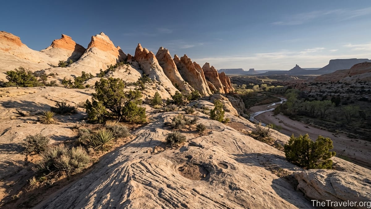
Comb Ridge does not reveal itself all at once. Approaching from the town of Bluff, Utah, the desert looks like a typical stretch of high plateau: low sagebrush, scattered juniper, the distant silhouettes of buttes. Then the land suddenly kinks. A serrated wall of Navajo Sandstone rises out of the earth and runs north to south for roughly 80 miles, from near the Abajo Mountains down toward Kayenta in Arizona. Geologists describe it as a monocline, a huge fold in the crust that tilts the rock layers skyward, but on the ground it feels like a frozen wave of stone, its white and tan fins catching the light.
When I first pulled off Highway 95 at one of the signed access points east of the ridge, the parking lot was almost empty. There was a simple vault toilet, an information sign about fragile desert soils, and a dirt path that disappeared into slickrock. No shuttle buses, no food trucks, no crowds. Just the quiet hum of wind in the rabbitbrush and the distant sound of a raven. This is Bears Ears country, co-managed today as Bears Ears National Monument by the Bureau of Land Management, the U.S. Forest Service, and a coalition of five Native American tribes, but on a weekday morning it can still feel surprisingly unclaimed by mass tourism.
The trail wound across the pale slickrock, over patches of loose sand and shallow washes that briefly hold water after storms. Within minutes of leaving the highway, the road noise dropped away. I could hear the crunch of my boots, the faint ticking of grasshoppers, and somewhere below, the invisible trickle of water in a shaded alcove. It was not a hard hike in terms of distance or elevation, but the shift from pavement to stone felt like crossing a threshold into a quieter version of the Southwest.
A Desert Classroom in Geology
Comb Ridge is the kind of place that makes a geology textbook feel suddenly alive. Standing on the eastern side, near the Butler Wash drainage that parallels the ridge, I could trace the tilted sandstone beds with my eyes, each layer recording a different chapter of Earth’s history. The Utah Geological Survey describes rock units here that span from roughly 280 million years ago in the Permian period to about 185 million years ago in the Jurassic. You do not need those numbers to appreciate the view, but knowing them adds weight to every step. The cross-bedded Navajo Sandstone at the crest once formed massive desert dunes; the rust-colored layers lower on the slope record ancient rivers and floodplains.
Walking near the base of the ridge, I ran my hand across the rock and felt how it changed under my fingers: fine-grained and almost silky in one spot, rough and pebbled in another. In shaded pockets where water sometimes seeps, the sandstone darkened and grew slick, streaked with desert varnish that had taken centuries to accumulate. The ridge is not just a scenic backdrop; it is a physical record of the forces that shaped much of the Colorado Plateau, including nearby features like the San Rafael Swell and the Monument Upwarp. Out here, those abstract names become visible lines and folds on the horizon.
What surprised me most was how quickly the character of the ridge shifted as I walked. In some stretches, the sandstone rose in smooth, sweeping domes that invited scrambling and exploration, like a smaller, quieter cousin of Zion’s slickrock. A few miles away, the same ridge broke into jagged spines and narrow gullies, its “comb” of rock teeth casting sharp shadows late in the day. For hikers who love varied terrain, this means you can spend a morning strolling over gentle stone and an afternoon weaving through steep fins, all without driving to a new trailhead.
Tracing Ancient Footsteps in Butler Wash
Modern hikers are latecomers to Comb Ridge. Long before there were highway pullouts or Bureau of Land Management kiosks, people lived, farmed, and traveled along these canyons. The eastern side of the ridge is etched with side drainages feeding into Butler Wash, and many of those canyons hold the remains of Ancestral Puebloan dwellings, storage rooms, and rock art panels. Some are signed and managed as developed sites; others are deliberately left unpublicized to protect them from damage and looting.
One of the most accessible introductions is the Butler Wash Ruins interpretive site off Highway 95, about a 20-minute drive from the small services in Blanding. A short, roughly half-mile trail leads across slickrock and sand to an overlook above a box canyon. From the fenced viewpoint, you can see a cluster of cliff dwellings tucked into the alcove opposite, built around 1200 AD and stabilized in places to prevent collapse. Even from a distance, the architecture is striking: rectangular rooms, circular kivas, and storage chambers stacked along the ledges. If you bring a pair of compact binoculars, you can pick out details like T-shaped doorways and wooden vigas.
Farther north and south along Lower Butler Wash Road, which runs parallel to the ridge as a graded dirt track, unnamed side trails lead to other sites with colloquial names like Monarch Cave, Split Level, and Fish Mouth. These hikes are generally a few miles round trip, weaving up sandy washes shaded by cottonwoods and tamarisk before narrowing into sculpted sandstone canyons. Rock art panels appear on varnished cliff faces: spirals, handprints, animal figures, and more abstract designs that may blend styles associated with Basketmaker, Ancestral Puebloan, and Fremont cultures.
Walking here changed my sense of time. It is one thing to read that people have lived in the Southwest for thousands of years; it is another to rest your back against the cool stone beneath a granary, looking down at the same wash that once carried water to cornfields on the floodplain. Because these sites are extremely fragile and still important to descendant communities, visitors are asked not to touch rock art, not to enter or lean on structures, and never to remove artifacts, no matter how small. Spending a day among the canyons of Butler Wash, it becomes obvious how quickly a careless boot or a thoughtless hand could erase stories that have survived for centuries.
Solitude, Silence, and the Sound of Ravens
Comb Ridge sits in the orbit of some of the most photographed landscapes in America. Monument Valley lies to the south along U.S. 163, Canyonlands National Park to the northwest, and Valley of the Gods spreads nearby with its own sculpted buttes. Many travelers race between these landmarks, pausing only at gas stations in Blanding or Mexican Hat. On my walk along the ridge, I started to wonder if the real luxury of the Southwest is not its icons but its pockets of quiet.
On a late spring afternoon, I followed a faint use trail up a sandy slope on the western side of the ridge, accessed from a side road off Utah 95. The climb was short but soft underfoot, climbing through piñon and juniper until the trees thinned and the sandstone spine came into view. At the crest, the world opened. To the west, the red mesas of Cedar Mesa and the distant cut of the San Juan River glowed in the low sun. To the east, I could see the pale band of Butler Wash, Highway 191, and the hazy outline of the Abajo Mountains.
There was no one else around. No voices, no music drifting from a trailhead, not even the hum of distant traffic. Instead I heard the wingbeats of a raven riding the thermals along the ridge and the dry rattle of wind through yucca blades. I had a few bars of cell service, but it felt almost impolite to pull out my phone. Places like this are rare in the Lower 48, even in big, famous parks. In Bears Ears, you can still find canyons where a full day passes without seeing another party, especially if you start early and avoid peak holiday weekends.
That solitude is not guaranteed. Local tourism boards now promote the region as part of Utah’s “Trail of the Ancients” scenic byway, and visitation to certain sites has increased significantly over the past decade. Yet as I sat on that sandstone fin, feet dangling over a hundred-foot drop into a narrow gulch, the ridge felt vast enough to absorb careful visitors. The trick, I realized, is respecting the pace of the place. Comb Ridge does not reward rushing; it opens up slowly, as you learn to notice its smaller patterns of light, color, and sound.
Planning Your Own Walk Along Comb Ridge
For travelers used to national parks with clear loops and boardwalks, planning a trip to Comb Ridge takes a bit more initiative. There is no single “official” trail that traverses the entire monocline. Instead, access comes via a network of paved highways and graded dirt roads that intersect the ridge at various points in San Juan County. The main paved approaches use Utah Highway 95, which crosses Butler Wash east of the ridge, and U.S. 163 near Bluff and Mexican Hat, where the ridge’s southern end comes into view from classic road-trip photo pullouts.
Most casual visitors base themselves in Blanding or Bluff, both of which offer a mix of motels, small inns, and vacation rentals. In Blanding, you can wake up at a simple roadside motel, grab coffee and a breakfast burrito at a local café, and be on the trail to Butler Wash Ruins in less than half an hour of driving. Bluff, a smaller and sleepier settlement along the San Juan River, has adobe-style lodges and campgrounds that attract river runners and photographers. Prices fluctuate by season, but budget travelers can often find motel rooms in the 80 to 120 dollar range on shoulder season weekdays, while more atmospheric inns may run higher.
Vehicular access shapes what you can see. A standard passenger car can comfortably reach the paved Butler Wash Ruins parking area and many viewpoints along Highway 95. Lower Butler Wash Road and Comb Wash Road, both unpaved, usually remain passable to high-clearance vehicles in dry conditions, but they can become muddy and rutted after storms. Before you commit to a side road, it is worth asking for current conditions at the Edge of the Cedars State Park Museum in Blanding, which doubles as an information center for Bears Ears National Monument, or at regional outdoor stores that keep informal tabs on washouts and closures.
Once on foot, routes range from half-hour strolls to all-day explorations. Family-friendly walks include the short trail to the Butler Wash Ruins overlook and some of the signed roadside viewpoints along Highway 95 where you can wander a few hundred yards onto slickrock benches. More adventurous hikers can choose side canyons off Lower Butler Wash Road or climb onto the spine of the ridge itself using steep but nontechnical social trails. Topographic maps, a reliable GPS app with offline maps, and conservative route-finding habits are essential, since there are few fences or formal trail markers once you leave the main interpretive sites.
Traveling Responsibly in Bears Ears Country
Walking along Comb Ridge forced me to grapple with the human story of the American Southwest in a way that postcards rarely invite. This is not an empty landscape. It is a living homeland for Navajo, Hopi, Zuni, and Ute peoples, among others, and a place where debates over public land, resource extraction, and heritage protection are still unfolding. In 2016, the area was designated as Bears Ears National Monument, then its boundaries were sharply reduced in 2017 before being restored in 2021. The monument today covers roughly 1.35 million acres of mesas, canyons, and buttes, including much of Comb Ridge and Cedar Mesa.
As a visitor, the politics can feel abstract until you stand beneath a rock art panel that has been scarred by graffiti, or see pottery shards that have been stacked into little cairns for photos. Land managers and tribal representatives have repeatedly emphasized that the biggest threats to the region’s cultural resources now come from unmanaged visitation rather than from simple neglect. Every time someone touches a petroglyph, climbs on a fragile ruin wall, or pockets an arrowhead, a non-renewable story is damaged or lost.
Responsible travel here starts with a few concrete choices. Stay on durable surfaces like slickrock and established trails instead of cutting across fragile crusts of black-brown biological soil. Pack out all waste, including toilet paper, in areas without toilets; in some canyons, human waste has become a serious issue because visitors assume the desert will somehow absorb everything. Never enter, sit on, or lean against ancient structures, even if they look abandoned. Photograph small artifacts where they lie rather than collecting them. And learn at least a few words about the tribes who consider this landscape ancestral and contemporary home, whether through exhibits at Edge of the Cedars Museum, storytelling events in Bluff, or tribally led tours that are beginning to appear in the region.
For many travelers, these guidelines feel like common sense, but on the ground it can be tempting to let curiosity override caution. Walking along Comb Ridge with these responsibilities in mind made my experience richer rather than more restricted. Knowing that I was moving through an “open-air museum” of living heritage encouraged a slower pace, longer pauses, and a more attentive gaze. Instead of hunting for the next Instagram-worthy ruin, I found myself savoring the textures of lichen on a boulder, the way late light painted the ridge in shades of copper and rose, and the echo of a canyon wren’s descending whistle against the stone.
Seasons, Safety, and the Reality of Desert Walking
The first thing most people notice when they step out of the car anywhere near Comb Ridge is the dry air. In spring and fall, when daytime highs often sit in the 60s to 80s Fahrenheit, it can feel pleasantly warm and breezy. Yet even on a mild day, the combination of altitude, sun exposure, and low humidity pulls moisture out of your body faster than you might expect. When I hiked in late April, carrying two liters of water for a half-day outing, I finished the last few sips just as I crested back over the final slickrock dome. On hotter days, in the 90s or above, prudent hikers often carry three or more liters per person, along with salty snacks to stave off cramps and fatigue.
Summer heat here is no abstraction. In July and August, temperatures in nearby towns like Bluff can spike well into the 90s and sometimes higher, and the rock itself radiates heat back at you like a slow oven. Many experienced hikers shift their schedules, starting before sunrise, taking a long midday break in shade or back in town, and returning to the ridge in late afternoon as the light softens. Winter can be sublime for solitude, with crisp air, scattered snow patches on the higher benches, and low-angle light turning the sandstone pastel. However, cold nights, icy patches in shaded canyons, and occasional winter storms mean you need warm layers and the flexibility to change plans.
Navigation and weather awareness are as important as water. Even signed trails like the path to Butler Wash Ruins cross stretches of slickrock where the route is marked only by small cairns or posts. In less developed areas, use trails sometimes fade in sandy washes, and it is easy to follow the wrong drainage or climb onto a bench that cliff-bands out above your intended route. A paper map, compass, and a downloaded digital map on a fully charged phone are cheap insurance. Afternoon thunderstorms in late summer can turn dry washes into short-lived torrents, so check forecasts in Blanding or Bluff and avoid deep, narrow canyons if heavy rain is predicted, even if the sky above you seems clear.
Despite these realities, walking along Comb Ridge is not reserved for elite desert experts. With reasonable preparation, almost anyone comfortable hiking a few miles on uneven terrain can enjoy the region. Start with a short, signed trail, carry more water than you think you need, wear a wide-brimmed hat and light long sleeves, and let your first day be an introduction rather than an endurance test. The reward is not just safety but the mental space to notice the subtler gifts of the landscape: the scent of wet creosote after a rare rain, the delicate pink of a blooming prickly pear, or the blue shadow of the ridge stretching across Butler Wash as the sun sinks toward the horizon.
The Takeaway
By the time I left Comb Ridge, dusted in red sand and still shaking a few grains of slickrock from my boots, my idea of the American Southwest had deepened. I had arrived with the usual mental catalogue of arches, buttes, and big-name parks. I left with a more layered appreciation: of deep geological time written in stone; of human histories that span far beyond the travel era; and of the fragile balance between inviting visitors and preserving what makes a place special.
Walking along the flank of this 80-mile monocline, you begin to see how interconnected the region is. The same forces that lifted the ridge also shaped nearby canyons, mesas, and river corridors. The same cultural threads that appear in a single Butler Wash alcove weave through Cedar Mesa, the Bears Ears buttes, and the broader Four Corners region. And the same questions about stewardship that hover over Comb Ridge echo in debates about other public lands across the West.
If you go, go with humility. Let your itinerary leave room for unscripted hours on the slickrock, for conversations with local residents and tribal members when opportunities arise, and for the possibility that a quiet morning on the ridge will rearrange your sense of what matters in travel. The American Southwest does not need more drive-by checklists. It needs more travelers willing to walk slowly, listen carefully, and leave places a little better than they found them.
FAQ
Q1. Where exactly is Comb Ridge located?
Comb Ridge runs roughly north to south for about 80 miles across southeastern Utah and into northeastern Arizona, near the towns of Bluff, Blanding, and Mexican Hat. It sits within and near Bears Ears National Monument and is easily seen from Utah Highway 95 and U.S. Route 163.
Q2. Do I need a permit to hike along Comb Ridge?
Most day hikes at established trailheads like Butler Wash Ruins currently do not require individual hiking permits, though some neighboring areas in Bears Ears and Cedar Mesa require permits for backpacking or specific canyons. Always check the latest guidance from land managers or local visitor centers before you go.
Q3. What is the best time of year to visit Comb Ridge?
Spring and fall are generally the most comfortable times, with milder temperatures and more stable weather. Summer can be extremely hot with intense sun, making early morning and late afternoon the safest windows, while winter offers solitude but can bring cold temperatures, snow patches, and occasional storms.
Q4. Can I reach Comb Ridge in a regular rental car?
Yes, you can see and access parts of Comb Ridge using a standard passenger car via paved highways and some graded dirt roads in dry conditions. However, side roads such as Lower Butler Wash Road and Comb Wash Road can become rough or muddy after storms, so a high-clearance vehicle and up-to-date local road information are recommended if you plan to explore beyond the main paved pullouts.
Q5. Are there marked trails, or is it all off-trail hiking?
There are a few signed trails, such as the short path to the Butler Wash Ruins overlook, along with some informal routes worn in by use. Much of the hiking, especially to less-known canyons and onto the crest of the ridge, involves following cairned routes or user paths rather than formally constructed trails, so good navigation skills are important.
Q6. Is it safe to visit the archaeological sites on my own?
Many established sites are safe to visit independently if you stay on designated paths, keep a respectful distance from structures and rock art, and follow all posted rules. However, because the area is remote and fragile, it is wise to travel with a partner, carry adequate water and navigation tools, and consider hiring a local or tribally affiliated guide if you want deeper cultural context.
Q7. Where should I base myself for exploring Comb Ridge?
The small towns of Bluff and Blanding in Utah are the most common bases, offering motels, inns, campgrounds, fuel, and basic groceries. Some travelers also stay farther afield in Monticello or near Mexican Hat and combine visits to Comb Ridge with side trips to Valley of the Gods, Monument Valley, or Cedar Mesa.
Q8. How much water should I carry for a day hike?
In the dry, exposed conditions around Comb Ridge, many hikers carry at least two to three liters of water per person for a half-day outing, and more for longer routes or hotter weather. Natural water sources can be seasonal, silty, or culturally sensitive, so it is best to plan as if you will find no reliable drinking water on your hike.
Q9. Are dogs allowed on hikes around Comb Ridge?
Many areas managed by the Bureau of Land Management allow dogs on leash, but specific rules can vary and dogs are generally discouraged near sensitive archaeological sites. If you bring a dog, keep it under control, pack out waste, avoid letting it dig or climb on ruins, and verify current regulations with local land managers.
Q10. How can I visit Comb Ridge respectfully as a guest on ancestral lands?
Travel respectfully by staying on durable surfaces, leaving artifacts where they lie, never touching rock art or entering ancient structures, and keeping noise levels low at cultural sites. Take time to learn about the Native nations connected to Bears Ears and, when possible, support tribally led businesses, guides, and cultural programs that share their perspectives on this landscape.