
Comb Ridge does not announce itself the way Zion’s cliffs or Arches’ stone spans do. For hundreds of miles across southeastern Utah, this sinuous wall of sandstone rises from the desert like the spine of some buried creature, separating deep canyons and hiding thousand-year-old dwellings in its shaded alcoves. It is difficult to spot on a map and easy to miss at highway speed, yet for travelers willing to leave the main parks behind, Comb Ridge is one of Utah’s most rewarding and least understood landscapes.
Get the latest updates straight to your inbox!
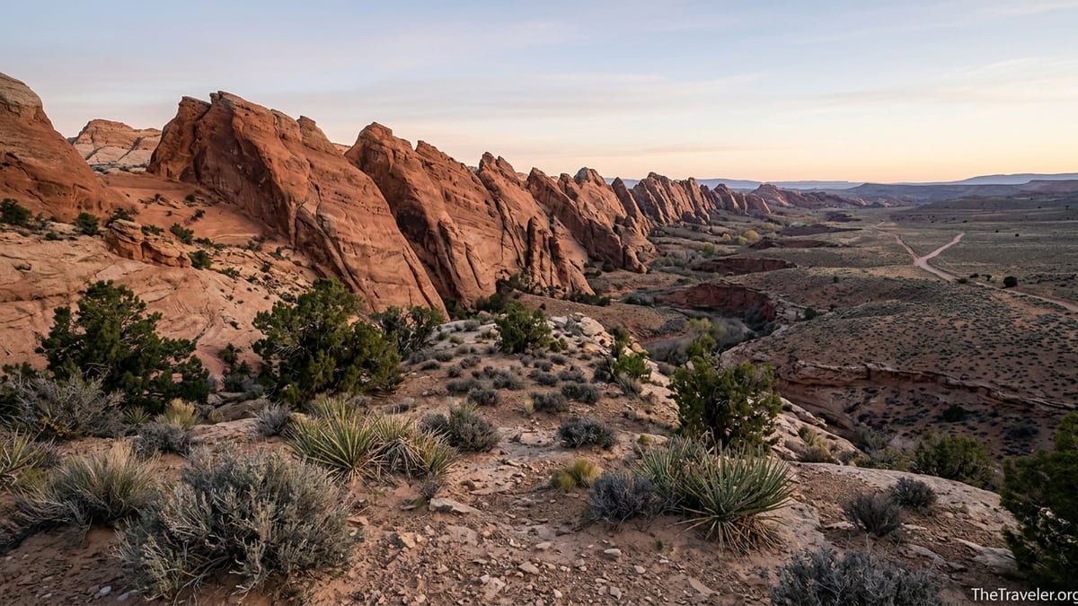
A Singular Geological Wonder in the Shadow of the Parks
Comb Ridge is a classic Utah paradox: enormous, dramatic, and somehow still largely overlooked. This sweeping monocline runs for roughly 80 to 120 miles, depending on how you measure its folds, from just north of the San Juan River in Utah into northern Arizona. On the ground, it appears as a repeating series of steep sandstone fins that rise several hundred feet above the surrounding desert, forming a jagged, comb-like spine that early surveyors in the 19th century compared to the back of a giant animal. Geologists describe it as one of the most striking examples of a monocline in the American Southwest, where sedimentary rock layers have tilted upward to form a single, monumental fold.
The drama is especially apparent where highways slice through the ridge. Drivers heading west from Blanding on Utah State Route 95 suddenly find themselves in a road cut that climbs directly through the tilted sandstone, offering textbook views of multicolored rock layers. A similar effect plays out on U.S. Highway 163 north of Monument Valley, where the road crosses the southern end of Comb Ridge near Bluff. In both places, you can park at small pull-outs and simply stare at the rock, tracing the lines of ancient sand dunes turned to stone and then bent upward by tectonic forces.
What makes Comb Ridge feel hidden is not its scale but its subtlety. From many angles it looks like a simple line of cliffs rather than a destination in its own right. There is no Comb Ridge National Park sign at the entrance, no main viewpoint with a big parking lot. Instead, the ridge is a place you inhabit gradually: by walking along sandy washes, climbing into side canyons, and noticing how the light changes on its walls throughout the day. It is less a standalone attraction and more a continuous presence threading through the Bears Ears region.
For the traveler familiar with Utah’s big-name parks, Comb Ridge offers a complementary experience. Where Zion can feel vertical and confined, Comb Ridge feels horizontal and open. Where Arches draws crowds to a handful of iconic formations, Comb Ridge invites you to explore dozens of unnamed alcoves and see how the rock shapes everyday life for plants, animals, and people across a huge sweep of country.
A Living Cultural Landscape, Not Just a Scenic Backdrop
Comb Ridge is not only a geologic landmark. It is also part of a cultural landscape that has been home to Indigenous peoples for thousands of years, and that connection is a major reason it feels so compelling. Much of the ridge and the canyons along its flanks lie within Bears Ears National Monument, which is co-managed by the Bureau of Land Management, the U.S. Forest Service, and a coalition of five tribes with ancestral ties to the area, including the Navajo Nation and the Hopi Tribe. Their histories here are written into the rock in the form of cliff dwellings, storage granaries, rock art panels, and quiet campsites overlooking seasonal springs.
On the east side of Comb Ridge, shallow drainages like Butler Wash and Comb Wash cut into the monocline and create a network of small canyons. Many contain alcoves where Ancestral Puebloan people built dwellings between roughly the 9th and 13th centuries. A short, signed trail from Utah 95 leads to an overlook of Butler Wash Ruins, a cluster of masonry rooms and kivas tucked into a cliff, with interpretive signs that explain how people farmed corn on the benches and stored food in secure, high alcoves. This is one of the more accessible sites, with a paved parking area, vault toilet, and a maintained path suitable for families.
Farther along the unpaved Butler Wash Road, more remote sites such as Monarch Cave, Split Level Ruin, and Tower House require short hikes across slickrock and sandy washes. Here the experience feels very different from a typical national park ruin trail. There are often no developed facilities, and the “trailhead” may be nothing more than a small pull-out and a faint path marked by cairns. You might spend an hour walking up a quiet canyon with only the sound of wind in the cottonwoods, then suddenly look up and see a two-story stone tower high in an alcove. The sense of discovery is intense, even though these sites are well known among local hikers and guidebook authors.
The presence of these cultural sites changes how you move through the landscape. In Comb Ridge’s canyons, you are not just admiring rock formations; you are walking through former homes, fields, and travel corridors. Pottery sherds and corn cobs sometimes appear near the base of alcoves, and rock art panels such as the Wolfman Panel add graphic, human detail to the sandstone walls. Visitors are asked to practice strict respect: not to touch rock art, not to enter fragile rooms, and not to disturb artifacts. For many modern Indigenous people, these are not abandoned ruins but living places that still hold stories, prayers, and responsibilities.
Where Solitude Still Feels Possible in Utah’s Desert
One of the most fascinating things about Comb Ridge is how quiet it can feel despite its location within a nationally famous monument. While visitation to Bears Ears has risen in recent years and popular stops like the Butler Wash Interpretive Site or the Procession Panel see steady traffic in peak season, the overall scale of Comb Ridge is so large that it is still easy to find yourself alone. A typical day might see a dozen cars at a signed trailhead in April, but if you drive a few miles down a side road and pick an unsigned canyon, you may not see another party at all.
This solitude is easiest to experience in the shoulder seasons of March to May and late September through October, when daytime highs in nearby Blanding and Bluff often sit in a comfortable range for hiking. Summer can be brutally hot, especially in the exposed slickrock sections above the canyons, and winter brings cold nights and occasional snow patches on north-facing slopes. For many travelers, a sweet spot is an April or October visit, when you can hike under cool blue skies and then watch alpenglow light up the ridge in the evening from a base in Bluff or a dispersed campsite along Comb Wash.
The road network itself helps keep things relatively low key. The main access on the east side, the Butler Wash Road, is a graded dirt track that runs roughly 18 miles between Utah 95 and U.S. 163. In dry conditions, it is usually passable in a high-clearance vehicle and often in a careful, low-clearance car, though wash crossings can become rough after heavy rain. On the west side, the Comb Wash Road parallels the base of the ridge and is a favorite for dispersed camping, with cottonwood-shaded spots along the usually dry wash. Because none of these roads are paved and services are essentially nonexistent, they naturally filter out casual traffic.
Compared with more intensively managed destinations, Comb Ridge feels like old-school desert travel. You are expected to bring your own water, pack out your trash, and know your limits. There are no shuttle systems, no snack stands at the trailheads, no rangers stationed in the canyons to answer questions. For many visitors, that is the appeal. You can pull off on a side track, study the map, and decide on a route that fits your energy and curiosity, then spend the day exploring without standing in a single line.
Accessing Comb Ridge: How Travelers Actually Get There
Reaching Comb Ridge is straightforward on a map but requires a bit of planning in practice. Travelers usually approach from two small gateway communities: Blanding to the north and Bluff to the south. From Blanding, Utah State Route 95 heads west toward Natural Bridges National Monument and crosses the ridge about 14 miles out of town, near the signed turnoff for the Butler Wash Ruins trail. This is the easiest first taste for many visitors, as you can drive from a motel in Blanding, hike a one-mile round-trip trail to an overlook, and be back in town for lunch.
From Bluff, U.S. 163 runs northwest toward Monument Valley and crosses the southern tip of Comb Ridge after a few miles. Just north of the crossing, an unsigned dirt road heads north along the east side of the ridge as Butler Wash Road, giving access to trailheads for Monarch Cave, the Wolfman Panel, and several unnamed canyons. South of the crossing, another network of rougher tracks explores the San Juan River side of the ridge, where sites like River House ruin look out over the water. High-clearance vehicles are strongly recommended in this area, especially after storms when clay sections can become slick and deeply rutted.
Fuel, groceries, and lodging are concentrated in Blanding and Bluff. Blanding offers chain motels, a couple of family-run inns, basic supermarkets, and gas stations, making it a practical base for those who prefer to return to a hot shower each night. Bluff, smaller and more atmospheric, has a mix of locally owned lodges and casitas, a few cafes, and river outfitters that run trips on the nearby San Juan. Prices vary seasonally, but it is common to find double-occupancy rooms in the spring shoulder season for rates in the lower to mid three figures per night, similar to other small Utah towns near public lands.
Campers can choose from a few developed options and extensive dispersed sites. Along Utah 95, basic BLM campgrounds and private campgrounds near Comb Wash offer vault toilets and picnic tables but usually no hookups. Dispersed camping on BLM land is allowed in many areas around Comb Ridge, particularly along Comb Wash Road and some sections of Butler Wash Road, though visitors are expected to use existing sites, respect any closures, and avoid camping directly on archaeological sites. Because this is a sensitive cultural landscape, it is increasingly important to check current regulations with the BLM or at information centers in Blanding or Bluff before choosing a spot.
Hiking the Ridge’s Hidden Canyons and Famous Alcoves
For most travelers, Comb Ridge comes alive on foot. The hiking here is less about summiting a single peak and more about following watercourses into the heart of the monocline. Many routes begin on sandy benches, enter shallow canyons lined with cottonwoods and willows, and then climb onto slickrock ramps that lead to alcoves where water once seeped from the rock. Because there is no single official trail system, hikers often rely on a combination of printed guidebooks, GPS apps, and local advice.
A popular and relatively straightforward option is the Butler Wash Ruins trail from Utah 95. The path meanders across low slickrock domes and shallow washes, with cairns marking the way to an overlook high above the ruins. The one-mile round trip makes it accessible for families and new desert hikers, yet the view into the alcove, with its cluster of masonry rooms and shade-loving plants, hints at the more complex canyons beyond. On busy spring weekends, breakfast crowds in Blanding will include hikers comparing notes about the best time of day for photos here, often recommending late morning when the sun reaches into the alcove without creating harsh shadows.
Experienced hikers often gravitate to longer, less developed routes like Monarch Cave, a hike that begins along Butler Wash Road and follows a sandy drainage before climbing slickrock to a large, amphitheater-like alcove. Here, tumbled walls, a small spring-fed pool, and an impressive round tower tell a story of intensive use and careful site selection. Elsewhere, hikes to Split Level Ruin or Tower House offer a mix of scrambling and route-finding, rewarding those who are comfortable navigating with a map rather than relying solely on signs. Many of these routes are three to six miles round trip, with modest elevation gain but plenty of uneven footing.
Because the canyons are relatively shallow, hikers can often combine several short excursions into a full day. A typical day might involve a morning visit to Butler Wash Ruins, a midday break in the shade of cottonwoods along Comb Wash, and an afternoon hike to a rock art panel such as the Wolfman Panel. Travel times between trailheads are short in miles but sometimes slow on dirt roads, so building in extra time for navigation, photo stops, and the occasional wrong turn is wise. Carrying at least several liters of water per person, sun protection, and a printed map is standard practice, even on apparently simple routes.
Traveling Respectfully in a Fragile and Active Monument
Comb Ridge’s status as both a geological showpiece and a cultural landscape makes respectful travel more than just a nice idea; it is essential. The area’s inclusion within Bears Ears National Monument reflects not only its scenic value but also the density of cultural resources that are irreplaceable and, in some cases, still actively visited or cared for by descendant communities. Visitors are encouraged to adopt a mindset closer to visiting someone’s home or place of worship than to exploring a generic wilderness area.
On a practical level, that begins with staying on durable surfaces like slickrock or established paths whenever possible, and avoiding the cryptobiotic soil crusts that appear as bumpy, dark patches on the desert floor. In the canyons, traveling in the sandy wash bottom minimizes impacts on vegetation and fragile slopes. When you reach a site, most current guidance from land managers and tribal groups emphasizes viewing from a distance, refraining from entering rooms or climbing onto walls, and never touching rock art. Even a single fingerprint’s oils can accelerate the deterioration of a painted figure that has survived for centuries.
Archaeological etiquette also extends to what you do not take. Pottery sherds, stone tools, and corncobs are common near some alcoves, and it can be tempting to pocket a “souvenir.” Doing so is illegal on public lands and, more importantly, strips context from the place. The recommended practice is to leave artifacts where they lie, photograph them in situ if you wish, and report any looting or fresh damage you might notice to local authorities. In recent years, increased visitation to Bears Ears and Comb Ridge has led to greater concern about impacts, and responsible behavior by individual travelers is one of the most effective tools in protecting these sites.
Because management approaches in the monument continue to evolve, it is wise to seek up-to-date information before heading into more remote corners of Comb Ridge. This might mean stopping by local information centers in Blanding or Bluff, checking official agency pages for the latest on permits and closures in nearby Cedar Mesa, or speaking with local Navajo guides who offer cultural context and route-finding expertise. Treating Comb Ridge as a place to learn from, not just to “do,” is part of what makes encounters here feel so memorable.
Planning a Comb Ridge Trip: Practical Tips and Real-World Scenarios
Building Comb Ridge into a broader Utah trip often involves choosing between a quick detour and a deeper dive. For travelers doing a classic loop between Moab, Monument Valley, and Lake Powell, an overnight stop in Bluff with a day along the ridge can be an efficient introduction. You might wake up in Bluff, drive 20 minutes to the southern end of Butler Wash Road, explore a canyon like Monarch Cave in the morning, move north to the Butler Wash Ruins trail on Utah 95 in the afternoon, then continue west toward Natural Bridges or south toward the Arizona border by evening.
Those with more time can easily spend three or four days exploring different sections of the ridge. A realistic multi-day plan could see you based in Blanding with day trips to Butler Wash Ruins and nearby Natural Bridges, followed by a move to Bluff for access to the southern canyons and the San Juan River. Each day might alternate between hiking and quieter activities like visiting small local museums, meeting with Navajo artisans, or taking a half-day rafting trip that passes beneath the cliffs of Comb Ridge.
Certain constraints are common. Rental car agreements sometimes discourage or forbid unpaved roads, which can limit access to trailheads along Butler Wash and Comb Wash. In that case, you might focus on paved-access sites such as Butler Wash Ruins and combine them with drives along the paved section of the Trail of the Ancients Scenic Byway, which crosses the ridge on Utah 95. Another real-world consideration is connectivity: cell service along the ridge is patchy to nonexistent, so downloading maps ahead of time and letting someone know your plans are basic safety steps.
Budget-wise, Comb Ridge can be a relatively affordable destination once you are in the region. There is no central entrance fee specifically for the ridge itself, and many of the trailheads are on BLM land with no day-use charge. Costs tend to come from lodging, fuel, and any guided services you choose. For example, a guided cultural hike with a local outfitter might cost a per-person rate comparable to half-day tours in Moab or Page, but with the added value of Indigenous perspectives on the land. Travelers who camp and cook for themselves from groceries bought in Blanding or Monticello can keep daily expenses modest while still enjoying long days in the canyons.
The Takeaway
Comb Ridge is one of Utah’s most fascinating hidden landscapes precisely because it does not fit neatly into the standard national park script. It is too elongated to photograph in a single frame, too full of quiet side canyons to reduce to a checklist, and too culturally important to treat as just another playground. Instead, it rewards travelers who are willing to slow down, look closely, and engage with a place that is both visually dramatic and deeply lived-in.
For those who have already stood in the crowds beneath Delicate Arch or along Zion’s Scenic Drive, Comb Ridge offers something different: the chance to walk unhurried through canyons where your main companions are wind and ravens, to glimpse ancient architecture tucked under stone overhangs, and to watch sunset paint a sinuous sandstone wall that stretches beyond the horizon. It is a landscape that asks for humility and attention, and in return, it offers a sense of discovery that is increasingly rare in the modern West.
Whether you experience Comb Ridge as a brief stop along a longer road trip or as the centerpiece of a dedicated Bears Ears journey, it has a way of lingering in memory. The arc of the ridge on the skyline, the sound of a small seep in a dry land, the feeling of cool alcove shade after a hot slickrock climb: these are the details that stay with you long after the map is folded away. For travelers ready to move beyond the obvious icons, Comb Ridge is exactly the kind of place that can reshape what a Utah adventure means.
FAQ
Q1. Where exactly is Comb Ridge, and how do I find it on a map?
Comb Ridge sits in southeastern Utah, primarily in San Juan County, between the towns of Blanding and Bluff. Look for the sinuous north–south sandstone ridge between Utah State Route 95 and U.S. Highway 163, with Butler Wash on the east side and Comb Wash on the west.
Q2. Do I need a four-wheel-drive vehicle to explore Comb Ridge?
You can reach some key sites, like Butler Wash Ruins on Utah 95, in a standard passenger car on paved roads. To travel the length of Butler Wash Road or Comb Wash Road and access more remote trailheads, a high-clearance vehicle is strongly recommended, and four-wheel drive is useful after storms or in muddy conditions.
Q3. Is Comb Ridge inside Bears Ears National Monument?
Yes. Large portions of Comb Ridge and the canyons along its flanks lie within Bears Ears National Monument, which is co-managed by federal agencies and a coalition of tribes. Monument status highlights both the scenic value and the cultural importance of the area.
Q4. Are permits required to hike in Comb Ridge?
Many day hikes along Butler Wash and Comb Wash currently do not require individual permits, especially at popular roadside sites like Butler Wash Ruins. However, nearby areas such as Cedar Mesa and some backpacking routes do have permit systems, and policies can change, so it is important to check current information with land managers before your trip.
Q5. What is the best time of year to visit Comb Ridge?
Spring and fall are generally the most comfortable, with March to May and late September through October offering moderate daytime highs suitable for hiking. Summer can be extremely hot on exposed slickrock, while winter brings cold temperatures and occasional snow or ice on shaded slopes.
Q6. Can I camp along Comb Ridge, and what are the options?
There are dispersed camping options on BLM land along roads such as Comb Wash Road and sections of Butler Wash Road, as well as a few basic campgrounds in the broader area. Campers should use existing sites, follow leave-no-trace practices, and verify current regulations or fire restrictions before setting up camp.
Q7. How difficult are the hikes, and are they suitable for families?
Difficulty varies. Short, signed trails like the one to Butler Wash Ruins are moderate and suitable for many families with basic fitness and sun protection. Other routes, such as hikes to Monarch Cave or Split Level Ruin, involve uneven terrain, route-finding, and some scrambling, and are better suited to experienced hikers comfortable with desert conditions.
Q8. Are guided tours available, and are they worth considering?
Yes. Several local outfitters and Navajo guides offer hikes and cultural tours in the Comb Ridge and Bears Ears area. Guided trips can add context about geology, archaeology, and Indigenous history, and are especially valuable for travelers unfamiliar with desert navigation or who want deeper cultural insight.
Q9. What special rules should I follow around archaeological sites?
Visitors should stay off walls and out of rooms, avoid touching rock art, leave artifacts where they are found, and photograph sites without moving anything. These practices protect fragile masonry, paintings, and context that cannot be replaced, and they align with requests from descendant communities and land managers.
Q10. How much time should I plan for a meaningful visit to Comb Ridge?
You can get a worthwhile introduction in a single day by visiting Butler Wash Ruins and one or two nearby canyons. To experience a broader slice of the ridge, including more remote hikes and quiet time in camp, many travelers find that two to four days in the area allows for a more relaxed and rewarding visit.