


Taganana, on the wild northeastern coast of Tenerife, sits where Anaga’s steep ravines finally meet the Atlantic. Laurel forest cloaks the ridges above, while drier slopes fall towards small whitewashed villages, terraces and black-sand coves. The result is superb hiking country for reasonably fit visitors, provided you choose routes carefully and account for Anaga’s famously changeable weather.
Get the latest updates straight to your inbox!
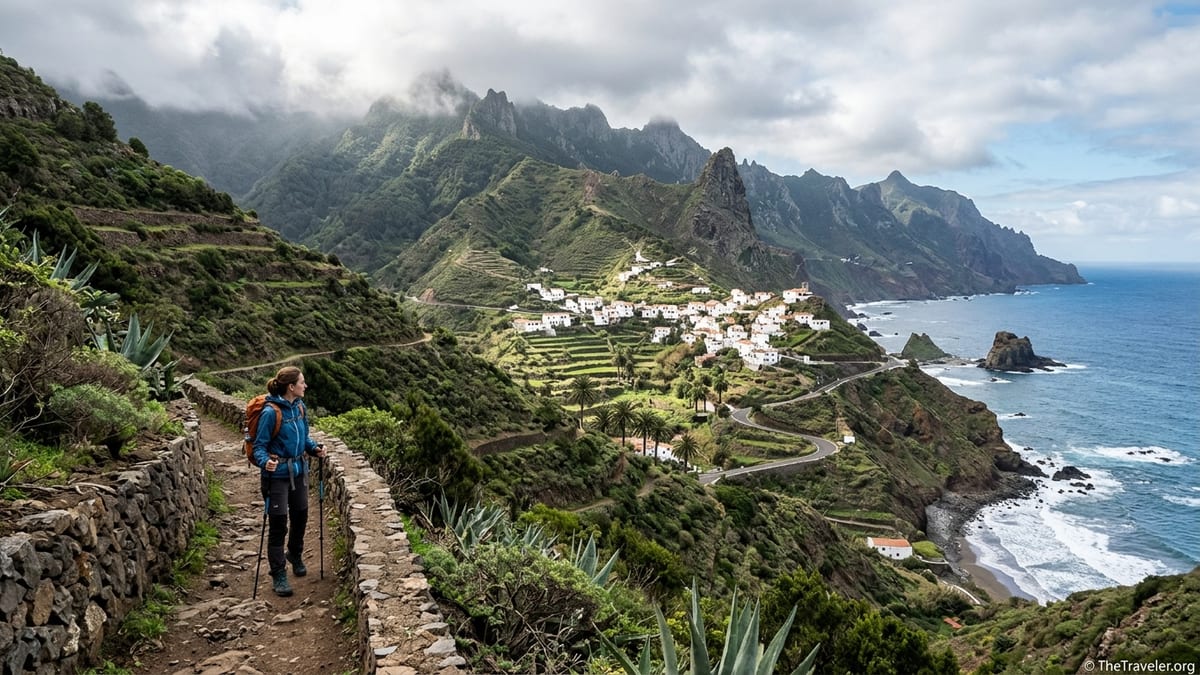
Anaga Hiking Context: Terrain, Weather and Trail Status
Anaga Rural Park is a protected mountain peninsula of deep ravines, knife-edge ridges and dramatic cliffs rising from sea level to around 1000 metres. Higher slopes often carry dense laurel forest that traps moisture from the trade winds, while the coastal side around Taganana, Almáciga and Roque de las Bodegas tends to be drier and more open, with scattered palm trees, terraces and exposed barrancos. Trails frequently link hamlets that for centuries were connected only by footpath, which means old stone ways that are steep, direct and sometimes rough underfoot.
Weather is highly variable at any time of year. Even on apparently settled days, cloud and mist can spill over the ridges, bringing drizzle or heavier showers, while sun can remain intense lower down by the sea. It is common to start in cool, damp cloud near El Bailadero and finish in bright sunshine in Taganana or on the coast, or the reverse. Temperatures can change quickly with altitude and wind, and paths may become muddy or slippery after rain, especially where shaded by forest.
Before describing individual hikes, it is essential for the writer preparing this guide to verify trail status close to publication. Official information from the Cabildo de Tenerife, the Anaga Rural Park management plan and Santa Cruz tourism authorities should be checked to confirm which waymarked routes are open, whether any diversions are in place after storms or landslides, and if specific sections are closed for restoration or safety works. Trails in ravines and on coastal cliffs are particularly vulnerable to rockfall and erosion after heavy rain, so conditions can change within a season.
Regulations within Anaga Rural Park also evolve. The writer should confirm via recent official or park-related sources whether any of the routes described have introduced permit systems, regulated access or recommended maximum group sizes, particularly if demand continues to grow. While at present most paths around Taganana remain free to walk without prior booking, wider Anaga policies on guided groups, commercial activities and route capacity may affect how visitors use these trails in coming years.
Access and Transport: Reaching Taganana and the Trailheads
Taganana is reached by a winding mountain road from Santa Cruz via San Andrés and the TF-12 ridge road. The main public transport option is bus 946, operated by TITSA, which runs between the Santa Cruz bus interchange and Almáciga, serving stops at El Bailadero junction, Taganana village and the coastal hamlets. Timetables checked in November 2026 indicate several services a day on both weekdays and weekends, with a typical journey time of about an hour from Santa Cruz to Almáciga, but exact departure times and any seasonal changes must be confirmed on the official timetable for the specific date of travel.
For car drivers, parking is limited in all the small villages of the area. In Taganana, spaces cluster near the church and along the main access road, but narrow streets and local traffic mean that visitors should park considerately and avoid blocking entrances or turning spaces. At Almáciga and Roque de las Bodegas there are small roadside parking areas close to the beach bars and coves, which can fill quickly on sunny weekends. El Bailadero has only a few pull-outs near the viewpoints and junction, often used by tour buses and other visitors stopping for panoramas over the Anaga ridges.
Using bus 946 effectively opens up some very attractive point to point routes. For example, walkers can ride up to a higher stop such as El Bailadero or the vicinity of Casa Forestal on the ridge road, then descend on foot to Taganana or Almáciga and return by bus later in the day. Conversely, early buses from Santa Cruz allow coastal-based hikers to climb towards the laurel forest and catch a later service back without needing to retrace their steps. For this style of hiking, the writer should instruct readers to check, on the exact date of their planned outing, that the specific departure and return journeys they rely on are running and that there are no temporary diversions.
Payment on TITSA buses typically uses contactless cards, mobile payment or local transport cards, but ticketing conditions and fare options change from time to time. Rather than quoting specific prices, which may date quickly, the writer should advise readers to consult current fare information shortly before travel and to carry a small reserve of cash or an accepted card in case of connectivity issues in remote areas.
Route 1: El Bailadero to Taganana via PR-TF-4
One of the classic ways to arrive in Taganana on foot follows a waymarked route often associated with PR-TF-4, descending from the ridge area around El Bailadero. In practical terms, this hike usually starts at or near the El Bailadero junction on the TF-12 road, served by bus 946 and with limited roadside parking. The path then traverses and descends towards Taganana, finishing in or near the main village square. Variants and short links can adjust the exact line, so current signposting and official route descriptions should be checked by the writer against the latest park documentation.
The full descent usually covers roughly 6 to 8 kilometres, with around 700 to 900 metres of mostly downhill elevation change, depending on the chosen variant, and typically takes between 2.5 and 4 hours for a reasonably fit hiker. The character is of a continuous descent on old paths and tracks, some shaded where the laurel forest hangs down from the ridge, then more open with sweeping views of Taganana’s white houses and the Atlantic as you approach the village. The surface can be rocky, with loose stones in places, and is often damp or muddy in the upper, forested sections.
Highlights include ridge viewpoints near the start, where on clear days you can see across deep ravines to the north coast, and later classic postcard views of Taganana framed by terraced slopes and distant surf. Old agricultural terraces, small chapels and traditional hamlets provide a sense of the area’s long-settled rural history. Because so much of the route is downhill, it may seem easier than its statistics suggest, but the cumulative impact on knees and ankles is significant, and the path can be slippery when wet. This route is not suitable for walkers who struggle with steep descents or have pronounced vertigo in narrow, exposed sections.
The most convenient logistics for many visitors involve taking bus 946 from Santa Cruz to El Bailadero in the morning, hiking down to Taganana, spending some time in the village, then catching a later bus back to Santa Cruz or continuing down to Almáciga and Roque de las Bodegas. The writer must remind readers to check the latest bus times in both directions and allow a safety margin, as missing the last service would leave them facing a long and potentially hazardous road walk in the dark.
Route 2: Taganana to Playa de Tamadite
The hike from Taganana to Playa de Tamadite offers one of the most dramatic combinations of ravine, cliff and wild beach in Anaga. Starting near the centre of Taganana, walkers follow a descending path into a deep barranco that cuts down towards the north coast. The exact line varies according to current waymarking and any diversions, but typically the path alternates between old mule tracks and narrower footpaths, sometimes running high above the ravine, sometimes closer to its floor, until it reaches the stony cove at Playa de Tamadite.
As an out and back from Taganana, this is usually a demanding day walk of around 9 to 12 kilometres total, with approximately 600 to 800 metres of cumulative ascent, depending on the chosen route and entry point into the ravine. Most fit hikers will need 4 to 6 hours for the full excursion, especially if they pause for views or a rest at the shore. The gradients are often steep, there are several narrow and occasionally exposed sections above drops, and the path can be rough and unstable in places. After rain, the ravine floor may be muddy or waterlogged, and rockfall is possible on steeper slopes.
The main reward is the sense of isolation and wildness so close to small villages. Views stretch out along the broken Anaga coastline, with inaccessible cliffs and pounding surf, while traditional terraces cling to the slopes behind. Playa de Tamadite itself is a remote, unserviced cove with no infrastructure, lifeguards or reliable mobile signal. Swimming here is strongly discouraged, as the Atlantic swell and currents can be powerful and unpredictable. Visitors should treat the beach as a viewpoint and picnic spot only, staying well clear of large waves and avoiding sitting directly under unstable cliffs.
For those with more time and stamina, the Taganana to Tamadite path can form part of a longer point to point route linking with Afur or other hamlets further inland, but such combinations quickly become full-day mountain hikes with significant elevation change. The writer should make clear that the Tamadite hike, even on its own, is already at the upper end of difficulty for casual holiday walkers and is not recommended for those with a fear of heights or knee problems.
Route 3: Taganana to Almáciga and Roque de las Bodegas
Taganana sits a short distance inland from the small coastal settlements of Almáciga and Roque de las Bodegas, linked historically by steep paths used by farmers and fishermen. Today, visitors can still follow these old connections, combining hill and sea views within a half-day outing. Most variants start near the church or main square in Taganana and follow waymarked paths that descend towards the TF-134 road, then either continue down to the beaches and coves or contour across the slope to reach Almáciga more directly.
As a one-way route, Taganana to Almáciga typically covers around 4 to 6 kilometres with 400 to 600 metres of descent, taking 2 to 3 hours at a relaxed pace. Those who want a more demanding loop can descend by one path and return by another, or continue along the coast between Roque de las Bodegas and Almáciga before climbing back to Taganana, which may raise the total distance to roughly 8 to 10 kilometres and add substantial ascent. Paths are generally clear but steep, with occasional sections near road cuttings or above short drops, and can be slippery on loose gravel.
Highlights include constant panoramas of the rugged coastline, with the distinctive offshore rock at Roque de las Bodegas and, further along, the striking outline of Benijo beach. Terraced slopes, scattered palms and small chapels help tell the story of a landscape where agriculture and fishing have long coexisted. On warm days, the beaches at Almáciga and Roque de las Bodegas are tempting places to rest, but again visitors should be warned that ocean conditions can be rough, and that lifeguard presence, red flags and facilities vary through the year. Only confident swimmers used to Atlantic surf should consider entering the water, and then only when local advice and flagged conditions indicate it is safe.
Logistically, many hikers choose to walk down in the morning, have lunch or a drink at one of the coastal establishments, then ride bus 946 back up to Taganana or onward to Santa Cruz. Because the road between Taganana and Almáciga is narrow and busy at peak times, walking on the tarmac is not recommended beyond short necessary crossings. The writer should emphasise that readers must check, for their chosen day, the times of the return bus from Almáciga and ensure they are at the stop in good time, as later services may be limited.
Route 4: Taganana Village Circular and Local Viewpoints
Not every visitor wants or needs a major ravine crossing to appreciate Anaga. Shorter circular walks around Taganana allow exploration of the village’s historic core, traditional terraces and nearby viewpoints, making them suitable for days with uncertain weather or limited time. Local tourism and municipal leaflets already describe a Taganana village route that links the main bus stop, church square and several streets lined with traditional houses. Building on that, walkers can extend their outing on signposted paths that climb above the village and return via different lanes.
Typical village-based circuits run to about 3 to 6 kilometres, with 150 to 300 metres of ascent, and take 1.5 to 3 hours depending on the exact variant and the number of photo and café stops. Paths combine quiet lanes, old stone steps, short stretches of track and occasional steeper footpaths above the houses. While there are no extreme drops, the cumulative effect of steps and slopes can still be tiring, and in wet weather the stone surfaces and narrow alleyways can become very slippery. Good footwear is recommended even for these shorter walks.
What these circuits lack in remoteness they make up for in cultural detail. Walkers can visit the main church, small plazas and local shops when open, observe the patterns of old terraces on the surrounding hillsides, and enjoy close-range views of the ravines that encircle Taganana without fully committing to a descent. Several signed viewpoints around the village give impressive angles on the Atlantic and the coastline towards Almáciga and Roque de las Bodegas, particularly atmospheric in late afternoon light.
Because these walks start and finish in the village, access is straightforward by bus 946 or by car, where parking is available. However, Taganana’s streets are narrow, and visitor numbers can surge on weekends, so the writer should encourage arrival by public transport where possible and stress the importance of respecting residents’ driveways and everyday routines.
Route 5: Ridge to Sea Variants via Casa Forestal and Surrounding Paths
Beyond the core paths described above, experienced hikers with a full day available can combine ridge and coastal sections to create longer traverses, for example starting near Casa Forestal on the TF-12 ridge road and descending via forest tracks and traditional paths to Taganana or Almáciga. Many of these lines are based on established waymarked routes and historic connections but involve more complex navigation than a simple out and back, so they demand good map-reading or a reliable GPX track from a reputable source.
A typical ridge to sea traverse might cover 12 to 16 kilometres, with 800 to 1000 metres of combined ascent and descent, taking 5 to 7 hours for fit, well-prepared walkers. The upper sections pass through dense laurel and heather forest, often in cool, humid conditions with limited visibility, before breaking out onto drier, more open slopes overlooking Taganana. Underfoot, the forest paths can be extremely muddy and rutted after wet spells, while sun exposure becomes a major factor lower down, especially in the middle of the day.
The appeal of these longer routes lies in the strong contrast between altitude zones, vegetation and microclimates in a single hike. Starting in dripping green forest among ferns and mosses, walkers eventually emerge to wide ocean vistas and the sound of surf. However, this very variety increases the importance of preparation. Anyone planning such a traverse should allow a generous time buffer, carry more water than they think they will need, and be ready with warm layers, sun protection and a headlamp in case the day runs over schedule.
Because these traverses often rely on starting or finishing at bus stops along the TF-12 or at Almáciga, it is essential to build the plan around confirmed bus 946 services on the chosen date. The writer should clearly instruct readers to check both the morning departure they intend to use to reach the ridge and the afternoon or evening service they plan to catch back from the coast or from Taganana, and to adjust their hiking ambitions if the current schedule offers only sparse connections.
Preparation, Safety and Environmental Considerations
Anaga rewards good preparation. Sturdy footwear with grippy soles is crucial on steep, uneven paths, particularly where laurel leaves or pine needles mask mud and wet rock. Walkers should dress in layers, including a light but reliable rain jacket, as temperatures can change quickly with altitude and wind, even in summer. Strong sun on the coastal slopes and beaches means a hat, sunglasses and high factor sunscreen are essential at all times of year.
Water availability on route is minimal. Outside the main villages such as Taganana, Almáciga or Roque de las Bodegas, there are generally no reliable public fountains, cafes or shops. Hikers should start each route carrying all the water they expect to need for the day, plus a safety margin, and bring adequate snacks or a light meal. Because mobile coverage can be patchy in ravines and remote coves, it is sensible to download offline maps in advance and, for longer or more complex routes, to carry a GPX track sourced from recognised mapping or park platforms rather than unverified social media posts.
Safety-wise, the biggest objective hazards are steep drops beside the path, loose or slippery surfaces and sudden weather changes. Walkers with vertigo may find certain sections between Taganana and Playa de Tamadite or along ridge paths uncomfortable or unsuitable. After storms or heavy rain, rockfall and landslides are possible, and some trails may be temporarily closed while damage is assessed and repaired. The writer should advise readers to seek recent local information before setting out after severe weather events and to turn back if conditions on the ground look unstable.
Environmental regulations in Anaga Rural Park are strict. Camping and bivouacking are generally not allowed within the park outside designated facilities, and recent regulations issued by the Canary Islands authorities reinforce restrictions on open fires, wild camping and overnight stays in forested areas. The writer must clearly discourage readers from attempting informal wild camping around Taganana, on beaches or along coastal cliffs, and instead recommend day trips or authorised accommodation in existing villages. Staying on marked paths helps protect fragile vegetation and reduces erosion, as well as lowering the risk of getting lost in complex ravine terrain.
When to Hike and How to Build a Short Stay around Taganana
Conditions for hiking around Taganana are often most pleasant during the cooler months from roughly late autumn through spring, when temperatures are milder and the laurel forest is at its greenest. Even then, overcast days and showers are common on the ridges, while sunny spells can feel warm by the sea. In summer, heat and strong sun on exposed coastal slopes make early starts advisable, aiming to finish the main climbs before midday and keeping the afternoon for shorter village circuits or time by the sea.
For a two to three day mini hiking break based in Taganana or Almáciga, visitors might combine one easier and one more demanding route, with flexibility to adjust according to weather. For example, a first day could focus on the Taganana village circular and a gentle descent towards Roque de las Bodegas, returning by bus or a short climb. A second day might tackle the El Bailadero to Taganana descent via PR-TF-4, using the bus up to the ridge and walking back down. On a third day, fitter walkers could choose between the Taganana to Playa de Tamadite route or a longer ridge to sea traverse that finishes on the coast.
Whatever combination is chosen, the key is to match route length and difficulty to realistic fitness and experience levels, and to leave room for weather and transport changes. The writer should end by reminding readers to reconfirm current trail conditions, bus lines and schedules shortly before each hike, to carry appropriate clothing, water and navigation tools, and to treat Anaga’s landscapes with the respect due to a protected and fragile mountain environment.
Approached in this way, Taganana becomes an ideal base for scenic, challenging but achievable day walks that showcase the full variety of Anaga, from misty laurel forest to sunlit terraces and wild Atlantic coves, all within a compact corner of Tenerife.