


Svartifoss is only accessible on foot. There is no roadside viewpoint or drive-up platform, and every visitor who wants to see the basalt-column waterfall must hike from Skaftafell’s main area along signed Vatnajökull National Park trails. That makes route choice and realistic timing especially important when you are planning a south-coast itinerary.
Get the latest updates straight to your inbox!
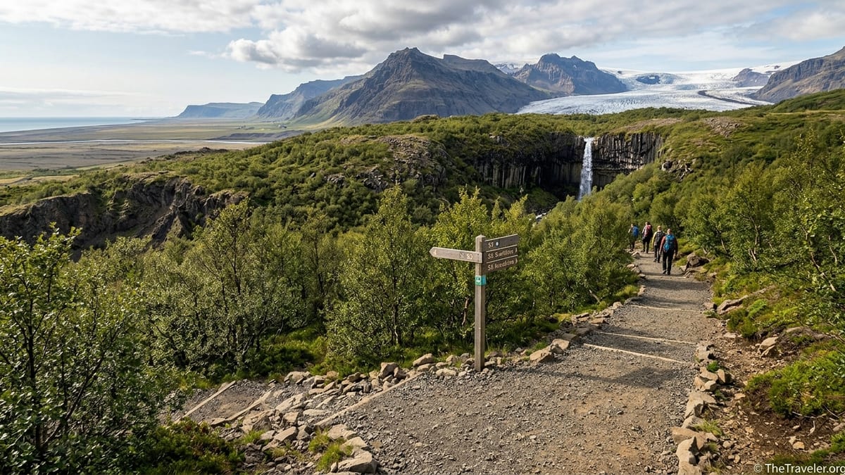
Trail system and starting points at Skaftafell
All official routes to Svartifoss start from the central Skaftafell area beside the Ring Road. The practical trailhead for independent hikers is Skaftafell visitor centre and the large car park and campground around it. Route posts, maps and information boards here use the national park’s letter-and-number system, with Svartifoss reached on routes including the S2 Svartifoss–Sjónarsker–Sel loop and the longer S6 Svartifoss–Sjónarnípa combination.
The lower section of every Svartifoss route follows the same broad corridor on a well-made gravel and hard-packed path that climbs out of the campsite area into birch scrub. This shared approach means you do not need to commit immediately to a loop or to the longer S6. Instead, you begin by following signs for Svartifoss and branch off at marked junctions such as Sjónarsker and Sjónarnípa once you have a sense of conditions, energy and weather higher on the hillside.
There is no alternative “short drive” route to a closer car park. Even the shortest way in practice is an out-and-back variation of the lower section of S2 that leaves and returns to the same visitor-centre area. National-park maps at Skaftafell and on official online pages provide the authoritative overview of route lines, junctions and current closures, and should always be treated as your primary reference for navigation.
Although many hiking apps and travel blogs share GPX tracks, these often pre-date recent trail realignments, erosion-control work or seasonal diversions. For the latest path positions and any access restrictions, always cross-check with the park map and the information board at Skaftafell before you set out.
The shorter out-and-back route to Svartifoss
The simplest option for most visitors is a straightforward out-and-back hike that uses the lower S2 corridor from Skaftafell visitor centre to Svartifoss and then returns the same way. In practice, this is the first part of S2 without completing the higher loop via Sjónarsker and Sel. Expect a total distance of roughly 4 to 5 kilometres return, depending on exactly where you start in the campground area and any small detours to viewpoints.
From the main car park and visitor centre, follow the signed path uphill toward Svartifoss. The trail climbs steadily on compacted gravel and occasional wooden or stone steps, trending roughly north from the visitor area into low birch woodland. Soon you reach views of Hundafoss, then Magnúsarfoss a little higher up the gorge, both visible from fenced lookouts just off the main path. Many families already treat these two falls as satisfying interim goals, but the main trail continues contouring and climbing toward the head of the ravine where Svartifoss comes into view.
The elevation profile on this out-and-back is simple: almost all the ascent happens on the way out from Skaftafell to Svartifoss, followed by a continuous descent back to the visitor centre. The gradient is moderate overall, but certain stair sections can feel steep if you are unused to hills. Underfoot, the surface is generally even and well maintained in summer, although short parts can become muddy and slick after heavy rain.
Vatnajökull National Park and current Skaftafell hiking summaries suggest allowing about 1.5 to 2 hours for the standard visit to Svartifoss using this line at an easy pace. Faster hikers who are comfortable with hills often complete the walk in around an hour, while photographers and families with small children commonly take longer because of stops at Hundafoss, Magnúsarfoss and the Svartifoss viewpoints. Build at least an extra half-hour buffer into whatever estimate fits your fitness level to account for crowds at the viewing platforms or slower progress on wet steps.
S2 Svartifoss–Sjónarsker–Sel loop from Skaftafell
The S2 route is the classic Skaftafell circuit that links the waterfall with broader views and a short cultural landscape section. Recent Skaftafell hiking overviews that draw directly on national-park data list S2 Svartifoss, Sjónarsker and Sel at about 5.8 kilometres, with around 250 metres of cumulative elevation gain and a suggested time of roughly 2 hours. It is graded easy within the Skaftafell system, but that assumes reasonable fitness and comfort walking on hilly paths.
The S2 loop begins the same way as the out-and-back: from the visitor centre you follow the signed Svartifoss path uphill past Hundafoss and Magnúsarfoss to the main Svartifoss viewpoints. After you have enjoyed the waterfall and the basalt-column gorge, you continue uphill briefly on the far side of the stream, following posts that indicate Sjónarsker rather than dropping directly back the way you came. The trail climbs to a broad shoulder with open panoramas over the sandur plains and out toward the ocean, with Sjónarsker providing a distinct high viewpoint.
From Sjónarsker, S2 swings back toward Skaftafell through gentle slopes and old grazing land around Sel, where turf remnants and farm ruins sit in a sheltered hollow. The path then descends gradually to rejoin lower tracks close to the visitor area, completing the loop without retracing your steps through the waterfalls. The overall elevation profile is a steady climb from Skaftafell to Svartifoss, a further short ascent to Sjónarsker, then a long, mostly gentle descent back to the starting point.
For timing, most visitors who walk S2 at a relaxed pace with plenty of photo stops take close to the two hours suggested by current Skaftafell route information. Strong walkers who are efficient at uphill hiking can often complete the loop in around 1.5 hours, while families with children, hikers unaccustomed to elevation and those stopping often at Sel or Sjónarsker viewpoints may prefer to allow 2.5 to 3 hours. If weather is changeable, snow patches linger or trail sections are slick, extra time is prudent.
S6 Svartifoss and Sjónarnípa combination route
Hikers wanting the fullest half-day outing from Skaftafell often choose the S6 Svartifoss and Sjónarnípa route. Current Vatnajökull National Park listings describe S6 as a challenging route of about 7 to 7.1 kilometres, with roughly 310 metres of elevation gain and a time estimate in the region of 2.5 to 3 hours. The greater distance and added height gain over S2, coupled with more exposed sections near Sjónarnípa, explain the tougher grading.
S6 also starts from Skaftafell visitor centre on the shared Svartifoss approach, again climbing past Hundafoss and Magnúsarfoss to Svartifoss itself. After visiting the main waterfall viewpoints, you continue on higher ground following signs toward Sjónarnípa rather than closing the S2 loop via Sjónarsker. The trail traverses above the gorge and then curves toward the edge of the Skaftafellsjökull glacier tongue, culminating at Sjónarnípa, a dramatic viewpoint perched high above the ice and the glacial lagoon.
The elevation profile for S6 can be thought of in three tiers: the initial steady ascent from Skaftafell to Svartifoss, a rolling but generally upward section to the Sjónarnípa rim, then an extended descent back toward the visitor centre on paths that share sections with other high routes. While the paths are well defined and signed, some stretches approach steep slopes and unfenced drop-offs around the glacier viewpoint. In poor visibility, strong winds or icy conditions, the exposed feel can make this route significantly more serious than S2, which explains its challenging label.
On a dry, calm summer day, experienced hikers who are comfortable on mountain paths tend to complete S6 near the lower end of the 2.5 to 3 hour estimate. More occasional walkers, groups stopping repeatedly to photograph Svartifoss and Skaftafellsjökull or anyone pacing themselves carefully on the uphill sections should expect to be out closer to the upper end of that range. If you are building a single-day south-coast itinerary that also includes glacier activities or long drives, plan your schedule based on the slower timing plus at least 30 minutes of margin.
Elevation, difficulty and who each route suits
All Svartifoss routes share two constants: a meaningful amount of uphill walking and a non-trivial descent. Even the shortest out-and-back route climbs continuously from Skaftafell visitor centre to Svartifoss on a gradient that many hikers will feel in their legs. S2 adds a modest extra rise to Sjónarsker before descending on a different line, while S6 extends the high-level section out to Sjónarnípa with more cumulative ascent.
Skaftafell’s current official grading considers the basic approach to Svartifoss and the full S2 loop as easy, while S6 is listed as challenging. In practical terms, fit walkers accustomed to hilly terrain will find the out-and-back and S2 straightforward in summer conditions, with the main effort concentrated in the initial climb and the careful footwork needed on the way down. Visitors who rarely hike or who have knee, hip or balance issues may find even the easier options tiring, especially on the stepped sections.
None of the Svartifoss routes are wheelchair accessible. Surfaces include compacted gravel, rock steps, roots and at times uneven natural stone. For parents considering these hikes with children, the out-and-back to Svartifoss offers the simplest logistics because you can turn around at any point, and the waterfalls provide natural progress markers. Confident older children with some hiking experience often enjoy S2 for its variety of views, while S6 is better reserved for teenagers and adults who are already comfortable walking on exposed hill paths.
For visitors prioritising scenery over exertion, it can help to think in terms of payoff versus effort. The lower section to Hundafoss and Magnúsarfoss gives rapid rewards for a relatively short climb. Reaching Svartifoss itself requires more ascent but delivers the famous basalt setting. S2 adds wide panoramas and historic farm remains for a modest increment, while S6 layers in a dramatic glacier vista at Sjónarnípa for a clearly higher physical and psychological commitment.
Seasonal trail conditions and winter safety
In the core summer season, typically late June through early September, the Svartifoss trails are usually clear of snow and well defined. During this time, the main considerations are changeable weather, potential mud and slick rock or wooden steps after rain. Even on bright days, showers can move quickly across the glaciers, so a path that was dusty an hour earlier may feel slippery underfoot by the time you descend.
In late autumn, winter and early spring, conditions shift significantly. Authorities and recent winter hiking reports consistently note that popular Icelandic waterfall trails, including Svartifoss, often become icy, with compacted snow on steps and shaded sections. Many independent hikers during recent winters have used microspikes or similar light traction devices to improve grip, especially on the steeper approaches and on the descent. Before publishing or relying on specific advice, it is essential to confirm the latest winter safety recommendations from Vatnajökull National Park and national travel-safety services, because guidance on equipment and open routes can change within a season.
Snow accumulation, freeze–thaw cycles and strong winds can all trigger temporary trail closures or small re-routings near exposed slopes. In these periods, expect walking times to increase meaningfully over the park’s summer-based estimates. A loop that might feel like a brisk two-hour outing in July can take considerably longer in February when much of the path is hard-packed snow or when you are moving cautiously over ice. Always check the current Skaftafell trail status and wider road and weather alerts on the morning of your hike and remain prepared to scale back your plans if conditions deteriorate.
Shoulders seasons in May and late September can mix summer-like sections with lingering snow patches higher up and icy spots in shaded gullies. This transitional period makes flexible footwear choices and a conservative approach to route selection especially valuable. Visitors unfamiliar with winter hillwalking techniques may be more comfortable limiting themselves to the lower Svartifoss out-and-back until they have seen the conditions first hand.
Gear, preparation and practical navigation
Regardless of season, sturdy waterproof footwear with good traction is strongly recommended for the Svartifoss hikes. Running shoes with smooth soles are more prone to slipping on wet rock, mud or compacted snow. Lightweight hiking boots or trail shoes with a pronounced tread strike a good balance for most visitors, while in winter dedicated traction devices can offer a real safety benefit if ice is present.
Layered clothing is essential in Skaftafell due to the rapid changes in weather that roll off Vatnajökull. Even on a sunny morning, cool winds and showers are common higher on the hillside. Carry a windproof and waterproof outer layer, a warm mid-layer and a hat and gloves outside of high summer. Pack snacks and at least a small bottle of water; there are no services on the trail itself, and it is easy to spend more time than expected at viewpoints.
Navigation on S2 and S6 is straightforward in clear weather because the routes are signed at junctions and well trodden, but do not treat that as a substitute for having a current map. Pick up the latest Skaftafell trail leaflet or consult the national park’s official online map before leaving the visitor centre, noting the colour codes or symbols used for S2 and S6 route posts at the time of your visit. While GPS apps can be a useful backup, remember that older tracks may show now-closed shortcuts or pre-realignment paths that are no longer recommended.
Finally, allow time at the start of your visit to check notice boards and speak with rangers or information staff. They can advise on the day’s conditions, crowd levels at Svartifoss and whether any part of the S6 route is subject to temporary warnings, for example due to cornices or cornice-like snow banks at Sjónarnípa in winter.
Visualising the route options without a map
For planning purposes, it can be helpful to sketch a simple mental diagram of the Svartifoss routes. Imagine the Skaftafell visitor centre at the bottom of a page. From it, draw a single curving line uphill that passes two small waterfall symbols in a row: Hundafoss first, then Magnúsarfoss. Continue the line to a star that represents Svartifoss near the top of the page. That shared trunk is the initial approach used by every route.
To represent the basic out-and-back, draw an arrow going from the visitor centre up to the Svartifoss star and the same arrow returning along exactly the same line. For the S2 loop, extend the line from Svartifoss a little higher to a viewpoint symbol marked Sjónarsker, then curve it broadly right and down through a small house icon labelled Sel before it reconnects with the starting point at Skaftafell. This creates an elongated loop with the waterfalls on one side and the farm remains on the return.
To add S6, again start from the same shared trunk to Svartifoss. From the waterfall star, draw the trail continuing along the hillside and then veering left toward a cliff-edge viewpoint marked Sjónarnípa overlooking a stylised glacier tongue. From there, sketch the return leg dropping back toward Skaftafell on a slightly different line that merges with other upper trails before reaching the visitor centre. This mental picture should help you keep track of the fact that all three main options share the same lower path and diverge only after Svartifoss.
When you arrive at Skaftafell, compare this mental sketch with the official map. Note especially how close together some junctions are, where you might be tempted onto a longer option unintentionally, and which posts or colour codes will mark the turnoffs for Sjónarsker, Sel or Sjónarnípa on the day of your hike.
Choosing the right Svartifoss hike for your visit
The best route to Svartifoss depends primarily on how much time you have in Skaftafell, your hiking experience and who is in your group. If you are stopping on a tight south-coast driving schedule and want a taste of the hills without risking delays, the shorter out-and-back to Svartifoss is the safest choice. It offers the headline basalt view and passes Hundafoss and Magnúsarfoss, yet can often be completed comfortably in around 1.5 to 2 hours plus buffer.
Travellers with a half day in Skaftafell and moderate fitness usually find S2 Svartifoss–Sjónarsker–Sel the ideal balance. It adds big-sky views and a glimpse of cultural history at Sel for only a modest increase in distance and ascent over the out-and-back, and it avoids returning through the same crowd flows below the waterfall. This makes it particularly attractive for those who like variety and are visiting in the busier summer weeks.
If you have a full day based around Skaftafell and are an experienced hiker, S6 Svartifoss and Sjónarnípa offers the most rewarding combination. Linking the waterfall with a high glacier overlook provides a strong sense of the wider Vatnajökull landscape in a single outing. In a one-day visit, S6 can serve as your main activity, leaving time for a short low-level stroll later. In a multi-day stay, it can be paired with easier trails such as the Skaftafellsjökull viewpoint route or used as a stepping stone before more demanding objectives like Skaftafellsheiði or Kristínartindar.
Whatever you choose, start with the official route descriptions, build your plan around the national park’s time estimates and honest appraisal of difficulty, and then add your own safety margin for weather, photograph stops and the simple pleasure of lingering at one of Iceland’s most distinctive waterfalls.