
The Bryce Amphitheater is the heart of Bryce Canyon National Park, a maze of fiery hoodoos and sheer cliffs framed by pine forest and high-desert sky. Whether you have a single sunrise or several days, understanding where the viewpoints are, how the trails connect, and how to move around the amphitheater will make the difference between a rushed stop and a truly memorable visit. This guide walks you through the essential overlooks, the classic hiking routes, and the latest practical information for visiting this world-famous natural amphitheater.
Get the latest updates straight to your inbox!
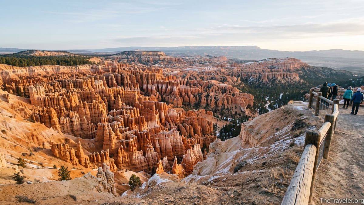
Getting Oriented to the Bryce Amphitheater
The Bryce Amphitheater occupies roughly the first three miles of the park road south of the visitor center, and it is the most developed and most visited area in Bryce Canyon National Park. Unlike a single canyon, it is a sweeping bowl of eroded limestone spires known as hoodoos, cutting into the eastern edge of the Paunsaugunt Plateau. Four primary rim viewpoints define this area: Bryce Point, Inspiration Point, Sunset Point, and Sunrise Point, all linked by the Rim Trail and served by the park shuttle during the main season.
For most visitors, the amphitheater will be your main focus, even if you have only half a day. The densest hoodoo formations sit directly below Sunset and Inspiration Points, while Bryce Point offers the broadest bird’s-eye perspective. A short, mostly flat paved section of the Rim Trail links Sunrise and Sunset Points, giving wheelchair users and visitors with limited mobility an accessible way to see the heart of the amphitheater from above.
The main road begins at the park entrance and quickly passes the shuttle station in Bryce Canyon City, the visitor center, and then climbs gently toward Sunrise and Sunset Points. Distances are short: from the visitor center to Sunrise Point is about a mile by car, and the four Amphitheater viewpoints are within a few minutes’ drive of one another. In practice, this compact layout allows you to combine multiple viewpoints and one or two hikes in a single day, particularly in late spring through fall when daylight is long.
Because of the park’s elevation, around 8,000 feet at the rim, everything here feels a bit more intense: the sun is stronger, summer thunderstorms build quickly, and winter snow lingers. Plan your schedule with altitude in mind, especially if you are driving up from lower desert regions in the same day and plan to hike below the rim.
Iconic Rim Viewpoints: Sunrise, Sunset, Inspiration & Bryce Points
Each of the four main viewpoints around the Bryce Amphitheater offers a distinct angle on the landscape. Sunrise Point, the northernmost, looks across a scattered field of hoodoos and ridges that catch the first low light of morning. Many visitors walk here in the pre-dawn chill to watch the hoodoos gradually go from blue to pink to bright orange, often with mule deer browsing in the meadows behind the rim.
Just to the south, Sunset Point stands nearly over the thickest concentration of hoodoos, including the famous Thor’s Hammer and other towering spires. Even though it is named for sunset, it is spectacular at any time of day, and it is also the trailhead for the Navajo Loop, one of the park’s signature descents into the amphitheater. The parking area here fills early in peak season, so arriving before 9 a.m. or using the shuttle is recommended if you want a convenient spot.
Inspiration Point sits higher and slightly back from the rim, providing a more elevated, layered view into the amphitheater. Short but steep paved walks lead to multiple levels of overlooks, each revealing deeper bands of hoodoos marching away into the distance. Visitors often describe this as the best place to understand the scale of the amphitheater, and the higher platforms can be windy and feel exposed, especially in winter or during shoulder-season cold fronts.
Bryce Point, at the southern edge of the amphitheater, is arguably the most dramatic vantage point. From here, you look north over the entire bowl, with early-morning light striking the hoodoos from the side and distant plateaus forming the horizon. The viewpoint is only a short walk from the parking area, making it a high-reward stop even for those who do not plan to hike. From the same lot, the Rim Trail begins its route north, while steep paths descend to longer routes like the Peekaboo Loop.
Rim Trail: The Easiest Way to Connect the Views
The Rim Trail is the backbone walking route along the Bryce Amphitheater. Officially about 5.5 miles one way between Bryce Point and Fairyland Point, the most popular section is the relatively flat half-mile stretch between Sunrise and Sunset Points. This segment is paved, mostly level, and suitable for strollers and many wheelchairs, making it a favorite for families and multi-generational groups who want big views without steep elevation changes.
From Sunset Point, the Rim Trail climbs gently south toward Inspiration Point and then more moderately toward Bryce Point. This southern section transitions from paved to hard-packed dirt and can feel more demanding, especially at altitude, but it rewards you with shifting perspectives on the amphitheater as you contour along the rim. Many visitors choose to ride the shuttle to Bryce Point and then walk back to Inspiration or Sunset, enjoying a net downhill walk with constant vistas.
To the north, the Rim Trail continues beyond Sunrise Point toward Fairyland Point, passing above more isolated hoodoo clusters and open pine forest. This less-trafficked segment provides a quieter rim experience, particularly in the early morning or late afternoon. It is a good option if popular overlooks feel crowded, as traffic and tour-bus groups thin out quickly once you leave the main parking areas.
Conditions on the Rim Trail vary by season. In winter, the portion between Inspiration and Bryce Points is often closed due to steep slopes and snow-ice buildup, while the section between Sunrise and Sunset Points tends to be kept open and maintained. Microspikes or traction devices can make a big difference here on cold, clear days when packed snow covers the path around the viewpoints.
Dropping Below the Rim: Queens Garden, Navajo Loop & Figure‑8 Routes
To truly appreciate the Bryce Amphitheater, many visitors descend at least partway below the rim, where the hoodoos tower overhead and the canyon walls narrow around you. The most popular descent is the Queens Garden Trail from Sunrise Point, often described as the gentlest route into the amphitheater. The trail drops along a ridge into a wonderland of spires and arches, with a turnaround point at the Queens Garden itself, a cluster of formations that some say resemble a queen surrounded by her court.
From Sunset Point, the Navajo Loop Trail offers a steeper, more enclosed experience, with famous switchbacks that zigzag between tall rock walls. In one branch known as Wall Street, the trail passes through a narrow corridor lined with Douglas-fir trees that stretch improbably toward the sky. Sections of Navajo Loop, especially Wall Street, are often closed in winter and may occasionally close in other seasons after storms or rockfall, so it is important to check current conditions at the visitor center before planning your route.
When both trails are fully open, the classic combination below the rim is the Queens Garden and Navajo Loop, often hiked as a roughly 3 mile circuit. A common pattern is to start at Sunrise Point, descend Queens Garden, traverse the connector at the bottom of the amphitheater, climb up the Navajo Loop to Sunset Point, and then walk the flat Rim Trail back to your starting point. Park rangers and many guidebooks recommend this clockwise direction because the descent on Queens Garden is more gradual, and it is generally safer to climb the steeper Navajo switchbacks than to descend them.
Stronger hikers might extend their day with the so-called Figure‑8 combination, linking Queens Garden, Navajo Loop, and the longer Peekaboo Loop into a single, more strenuous outing of roughly 6 to 7 miles, with significant cumulative elevation gain. This route is best tackled in cooler months or early in the morning in summer, and only by those already acclimated to the 8,000-foot elevation. Carrying at least two liters of water per person is a prudent baseline, and more in hot weather.
Seasons, Weather & Trail Conditions in the Amphitheater
Bryce Canyon is a true high-country park, and that shapes the experience in the amphitheater throughout the year. Summer daytime highs are usually comfortable compared with nearby desert parks, often in the 70s or low 80s Fahrenheit, but the high sun and thin air can make exposed trails feel hotter than the thermometer suggests. Afternoon thunderstorms are common from roughly July through early September, bringing lightning risk to exposed viewpoints, so early morning starts are often the safest plan for below-the-rim hikes.
Spring and fall can be ideal for hiking, with cool mornings and crisp, clear air, but conditions can change quickly. A warm October afternoon can be followed by a hard freeze and light snow overnight. Shoulder-season visitors should travel with layers, including a windproof jacket, hat, and gloves, even if the forecast looks mild when they leave nearby towns such as Panguitch or Tropic.
Winter transforms the Bryce Amphitheater into a snow-draped scene that many photographers and repeat visitors consider the park at its best. The contrast of white snow on red and orange hoodoos is striking, especially under low golden light. However, winter brings practical challenges: portions of trails like the Wall Street side of Navajo Loop typically close for the season, sections of the Rim Trail may close after storms, and the main road beyond the amphitheater can temporarily shut down for plowing. Footing at viewpoints and on open trails can be icy, making traction devices and hiking poles highly recommended.
Year-round, elevation affects how visitors feel on the trails. Many travelers arrive from Las Vegas or lower Utah deserts on the same day they plan to hike below the rim. Even short climbs can feel surprisingly strenuous here, and it is common to see fit hikers pausing frequently to catch their breath on the way back to the rim. Taking your time, drinking water steadily, and avoiding a rushed first-afternoon hike after a long drive can go a long way toward making your amphitheater experience enjoyable rather than exhausting.
Shuttle, Parking & Navigating Busy Days
From roughly early April into October, Bryce Canyon operates a free shuttle system that connects Bryce Canyon City, the visitor center, and the key amphitheater viewpoints. The shuttle is included with park admission and typically runs every 15 minutes during the day, with extended evening hours in peak summer. It is often the most predictable way to reach Sunrise, Sunset, Inspiration, and Bryce Points when parking lots fill, especially between late morning and mid-afternoon.
Drivers of larger vehicles should be aware that, during shuttle season, there are restrictions on parking for rigs over a certain length in the Bryce Amphitheater area. For many RV travelers, the simplest approach is to park at the shuttle station in Bryce Canyon City or at the overflow lot near the visitor center and ride the shuttle to the viewpoints and trailheads. This reduces congestion and saves the frustration of circling small lots at busy overlooks.
On quieter shoulder-season days when the shuttle is not running, personal vehicles are allowed at all amphitheater lots, and it is easier to move between viewpoints on your own schedule. Even then, early arrival remains wise. Tour buses are most common from mid-morning onward, often timing stops at the amphitheater for between 10 a.m. and 3 p.m. If you want uncrowded photographs from Sunset Point or a peaceful walk along the rim, sunrise or late afternoon are your best windows.
Wayfinding within the amphitheater area is straightforward. Brown-and-white signage at each viewpoint clearly marks trailheads like Queens Garden, Navajo Loop, Rim Trail, and Peekaboo Loop, and park maps handed out at the entrance and visitor center highlight distances and estimated hiking times. Before dropping below the rim, many hikers stop at the visitor center to confirm which trails are fully open, how muddy or icy conditions might be that day, and whether any weather alerts could affect afternoon lightning or winter storm timing.
Practical Tips for a Safe and Memorable Visit
Simple preparation makes a big difference in how enjoyable your time in the Bryce Amphitheater will be. Footwear is one of the most important choices. Even though some viewpoints and sections of the Rim Trail are paved, most below-the-rim routes are dirt, often dusty and scattered with loose gravel in summer or patches of ice in winter. Lightweight hiking shoes or trail runners with good traction are far safer and more comfortable than smooth-soled sneakers or sandals, particularly on the switchbacks of Navajo Loop or the steeper edges of the Rim Trail.
Hydration and sun protection are equally critical. At 8,000 feet, UV exposure is higher than at sea level, and there is little shade once you step away from forested sections. A brimmed hat, sunglasses, and broad-spectrum sunscreen are standard kit. For hikes below the rim, many park staff and experienced visitors recommend at least one liter of water per person for short loops like Queens Garden alone and two liters or more for combined routes such as the Queens Garden and Navajo Loop or the Figure‑8. Small daypacks make it easy to carry extra layers, snacks, and a simple first-aid kit.
Families and visitors with mixed abilities can still enjoy the amphitheater’s highlights with some planning. For example, a common half-day itinerary might involve boarding the shuttle at Bryce Canyon City, riding to Bryce Point for the panorama, then returning to Sunset Point. Some group members might stroll the flat Rim Trail to Sunrise Point while others relax at the viewpoints or at the nearby lodge area. Those seeking a mild descent can try just the upper part of Queens Garden, turning around at the first major switchback if the grade feels too steep.
Finally, remember that Bryce Canyon is home to wildlife and fragile soils. Ravens, chipmunks, and mule deer are commonly seen around the amphitheater and may approach people expecting food. Feeding wildlife teaches them to associate humans with handouts and can lead to aggressive behavior or poor health. Staying on designated trails prevents erosion on the steep, crumbly slopes and protects the vegetation that stabilizes the hoodoo formations over time.
The Takeaway
The Bryce Amphitheater concentrates the most famous views, the most accessible walks, and the classic hoodoo hikes in Bryce Canyon National Park into a compact, easily navigable area. With four major viewpoints, a rim-top walking route, and several interlocking trails below the rim, it offers options for every energy level and every season of the year.
By starting early, using the shuttle when it is available, choosing trails that match your fitness and comfort with altitude, and staying flexible around weather and seasonal closures, you can experience the amphitheater at its best. Whether that means a single sunrise from Bryce Point, a family stroll between Sunrise and Sunset Points, or a full-day descent through Queens Garden and Navajo Loop, the amphitheater rewards any amount of time you can give it.
Most visitors leave Bryce Canyon with a mental picture of the amphitheater that stays with them for years: rows of red and orange spires catching the first or last light of the day, silent except for the wind. With a bit of planning and an understanding of how the viewpoints and trails fit together, that image can be more than a quick roadside stop; it can be the centerpiece of a well-paced, memorable journey through one of the Southwest’s most distinctive landscapes.
FAQ
Q1. What is the best time of day to see the Bryce Amphitheater?
The amphitheater is beautiful all day, but sunrise and the first few hours of morning offer the most dramatic light and generally smaller crowds. Hoodoos catch side light, shadows add depth, and summer thunderstorms are less likely early in the day.
Q2. How much time do I need to see the main viewpoints?
With two to three hours, you can visit Sunrise, Sunset, Inspiration, and Bryce Points using the shuttle or your own car, and walk the easy Rim Trail between Sunrise and Sunset. Add another two to three hours if you plan to hike partway below the rim.
Q3. Are there easy trails suitable for families and less experienced hikers?
Yes. The paved Rim Trail between Sunrise and Sunset Points is mostly flat and ideal for families and many visitors with limited hiking experience. The upper portion of Queens Garden can also work as an easy out and back if you turn around before the steeper switchbacks.
Q4. What should I know about altitude and fitness before hiking below the rim?
The rim sits around 8,000 feet above sea level, so climbs feel harder than similar hikes at lower elevations. Even fit hikers may need frequent breaks on the ascent. Start with shorter routes, drink water steadily, and avoid tackling the longest loops immediately after a long drive from lower elevations.
Q5. Is the Bryce Canyon shuttle worth using?
For many visitors, yes. During the main season, parking at Sunset, Inspiration, and Bryce Points can fill by mid-morning. The shuttle is free with park admission, generally runs every 15 minutes, and lets you move between viewpoints without worrying about finding a space.
Q6. Can I visit the amphitheater in winter?
Absolutely, but you need to be prepared. Expect cold temperatures, possible snow and ice, and seasonal trail and road closures. Traction devices, warm layers, and checking current conditions at the visitor center on arrival are essential steps for a safe winter visit.
Q7. Which below-the-rim hike is best for a first visit?
If conditions allow, the Queens Garden and Navajo Loop combination is often considered the classic first-timer hike. If you prefer something less strenuous or if parts of Navajo Loop are closed, an out-and-back on Queens Garden from Sunrise Point still delivers an excellent taste of the amphitheater from below.
Q8. Are pets allowed on the Bryce Amphitheater trails?
Pets are allowed on paved surfaces such as campground roads, parking areas, and the paved stretch of the Rim Trail between Sunrise and Sunset Points, but they are not permitted on most dirt hiking trails below the rim. Visitors traveling with pets should plan to focus on the rim viewpoints and paved paths.
Q9. What gear do I need for a day in the amphitheater?
For most visitors, sturdy walking or hiking shoes, a small daypack, water, snacks, sun protection, and a light insulating layer are the essentials. In colder months or after storms, traction devices for your shoes and trekking poles are highly recommended for icy paths.
Q10. Do I need a guide, or can I explore on my own?
Most travelers explore the Bryce Amphitheater independently using park maps and well-marked trails. Ranger-led walks and talks are sometimes offered in peak seasons and can add context about geology and ecology, but they are not required to navigate the viewpoints and main hikes safely.