
Bryce Canyon National Park looks like nowhere else on earth, with orange hoodoos, narrow slots and a rim that feels almost otherworldly. To really appreciate it, though, you need more than a pretty viewpoint. The best Bryce trips start with good trail maps, a sense of how the shuttle and roads work, and realistic expectations about weather, crowds and trail conditions. Here is a practical, up to date guide to finding Bryce Canyon trail maps, choosing the right hikes, and navigating visitor logistics in 2026.
Get the latest updates straight to your inbox!
How to Get Reliable Bryce Canyon Trail Maps in 2026
The single best source for current Bryce Canyon trail maps is still the National Park Service. When you pass the entrance station you can usually ask for the free paper park brochure, which includes a clear map of the Bryce Amphitheater rim, the main viewpoints and classic trails such as Navajo Loop, Queen’s Garden, Peekaboo Loop, Fairyland Loop and the Rim Trail. It is detailed enough for typical day hikes and fits easily into a jacket pocket, which matters once afternoon winds start tugging at anything loose.
For more detail, stop at the Bryce Canyon Visitor Center about one mile past the entrance gate on Utah State Route 63. Rangers there can point you to the large wall map, the seasonal Bryce Canyon Visitor Guide and printed day hike handouts that show distances, elevation change and estimated hiking times for each trail. These handouts are especially valuable when parts of Navajo Loop or other routes are closed due to rockfall or mudslides, something that has happened several times recently.
Many travelers also use digital maps. Apps like AllTrails and Gaia GPS list routes such as the Figure 8 Combination (Queen’s Garden, Navajo and Peekaboo), Fairyland Loop and the Under the Rim Trail with mileage, elevation profiles and recent trail reports from other hikers. Cell coverage inside the canyon is patchy, so always download maps for offline use before you arrive. Think of digital tools as a supplement, not a replacement, for the official paper map and ranger advice.
If you are planning longer backcountry trips on the Under the Rim or Riggs Spring Loop, invest in a waterproof topographic map from a reputable brand sold at the visitor center bookstore. These show water sources, campsites and contour lines in far more detail than the free brochure, which becomes important once you are several miles from the amphitheater and the hoodoos give way to forest and open plateau.
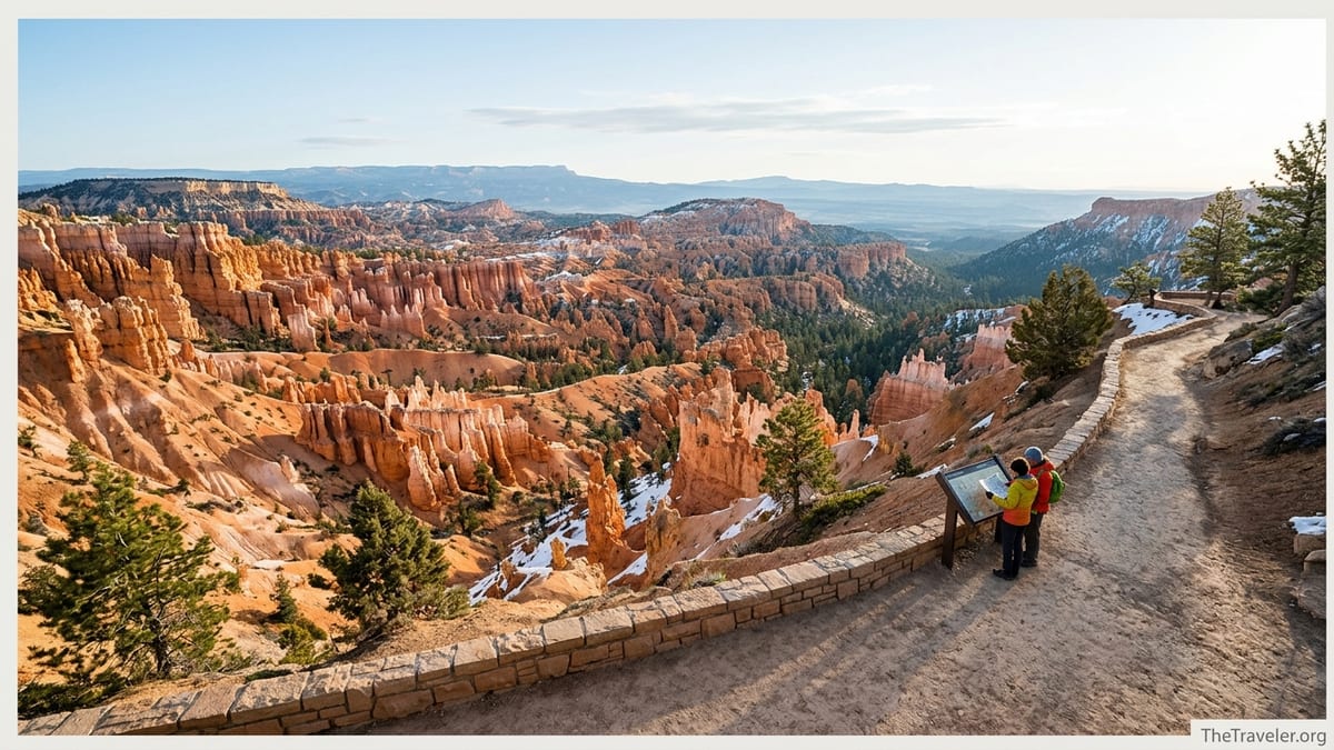
Understanding Bryce Canyon’s Main Hiking Areas
Most visitors spend their time in the Bryce Amphitheater, the dramatic bowl of hoodoos and fins that sits below Sunrise, Sunset, Inspiration and Bryce Points. The majority of popular hikes start from these viewpoints, which means you can combine short sections of several trails into a custom route depending on weather, fitness and how crowded it feels along the rim.
The easiest way to orient yourself is to imagine the rim road running north to south. Sunrise and Sunset Points anchor the central area, Inspiration Point sits just to the south, and Bryce Point further along the road offers a higher perspective looking back over the amphitheater. Trails like Queen’s Garden descend from Sunrise Point, Navajo Loop drops from Sunset Point, and the Rim Trail connects the viewpoints along the top. More demanding loops such as Peekaboo and the Figure 8 combination connect these descent routes in the canyon’s interior.
Outside the main amphitheater, Fairyland Loop begins near Fairyland Point on the park’s north end and offers a quieter, full day feel. Further south along the scenic drive you will find shorter loop options like Mossy Cave (technically outside the fee station), Bristlecone Loop and the trail network associated with the Under the Rim and Riggs Spring backcountry routes. These areas can feel surprisingly remote compared with the busy amphitheater overlooks, especially early or late in the day.
This mental map helps when you are looking at the printed trail map or the shuttle diagram. If you know that you want to start at Sunset Point, end at Bryce Point and hike mostly downhill along the rim, a ranger can quickly suggest the right one way route and which shuttle stop to aim for at the finish.
Signature Trails: Distances, Difficulty and Typical Experiences
For most first time visitors a single loop inside the amphitheater is the highlight of Bryce. The classic option is the Queen’s Garden and Navajo Loop combination, usually around 2.9 miles total with about 600 feet of elevation loss and gain. On a typical morning you might start from Sunrise Point, follow gentle switchbacks into the canyon past formations that resemble a storybook queen, then return to the rim by climbing out via the steeper Navajo side that passes close to Thor’s Hammer and the famous, narrow Wall Street section when it is open.
If you prefer something shorter and less steep, the paved section of the Rim Trail between Sunrise and Sunset Points is an accessible option of about half a mile one way. Families often push strollers here, and people with limited mobility can still enjoy sweeping views into the hoodoos without committing to a descent. On a busy July afternoon it is common to see visitors in sandals strolling this stretch with an ice cream from the lodge, while more prepared hikers below navigate the switchbacks with trekking poles.
Fairyland Loop, roughly 8 miles with about 1,500 feet of elevation change, offers a more solitary experience. Many hikers start early from Fairyland Point or from Sunrise Point by following the rim north and then dropping into the loop. Expect long stretches where you may only see a handful of people, plus constantly shifting angles on the hoodoos and distant plateaus. This makes a rewarding day for fit hikers who have already done the main amphitheater routes or want to escape peak season crowds.
Peekaboo Loop, typically around 5.5 miles when accessed from Bryce Point or combined with other trails in the Figure 8, weaves in and out of tight hoodoo formations with more frequent ups and downs. Horses and guided horseback tours also use this route in season, so hikers should be ready to step aside on narrow sections. The constant climbs can feel punishing in afternoon heat, so a pre 9 a.m. start with plenty of water is strongly recommended in summer.
Seasonal Conditions, Closures and Safety on Bryce Trails
Bryce Canyon sits at over 8,000 feet of elevation, so trails can be icy or snow covered for much of the year. From late fall through early spring, the park frequently recommends traction devices like microspikes on steep routes such as Navajo Loop and Queen’s Garden. It is not unusual in December to see visitors at Sunset Point in light sneakers gingerly stepping onto packed snow, while better prepared hikers pass by with insulated boots, gaiters and trekking poles.
In recent seasons, the park has temporarily closed parts or all of Navajo Loop because of rockfall or mudslides. Even in 2026, travelers have reported full loop closures after storms, with only the Queen’s Garden side or the Two Bridges side of Navajo open. This can turn the usual loop into an out and back or a modified lollipop, so always check the current conditions page or ask a ranger at the visitor center before committing to a specific plan.
Summer introduces different challenges. Afternoon thunderstorms are common from roughly July through early September. Lightning is a serious hazard along the exposed rim and in open sections of the canyon, so aim to finish major hikes by early afternoon and avoid starting long loops if dark clouds are building to the west. Temperatures can feel warmer than the forecast once you are surrounded by reflective orange rock, making sun protection and adequate water essential.
Regardless of season, basic safety gear makes a real difference. Closed toe shoes with good tread, at least one liter of water per person for short hikes and more for longer loops, a sun hat, layered clothing and a printed map should be considered standard. Every year rangers assist dehydrated or disoriented hikers who underestimated the combination of altitude, steep climbs and quickly changing weather.
Visitor Center, Entrance Fees and Getting Around the Park
Bryce Canyon National Park is open 24 hours a day year round, though services operate on seasonal schedules. The main visitor center, one mile past the entrance on UT 63, typically opens at 8 a.m., with closing times that shift from around 4:30 p.m. in winter to 8 p.m. in peak summer. It is usually closed on Christmas Day and parts of some winter holidays, so if you arrive very early or very late you may need to rely on posted information instead of speaking with a ranger in person.
Entrance fees are collected at the park gate. In 2026, the standard private vehicle fee covers up to seven days of entry for everyone in the car, while pedestrians and cyclists pay a per person rate. International visitors should be aware of a new nonresident surcharge that applies at Bryce and several other popular national parks. Many travelers find that purchasing the annual America the Beautiful pass makes financial sense if they plan to visit multiple parks in a year, such as combining Bryce with Zion, Arches and Canyonlands on a Southwest road trip.
Parking at the main viewpoints can fill by mid morning in peak months, leading to congested lots at Sunrise, Sunset, Inspiration and Bryce Points. A practical workaround is to leave your car at the Bryce Canyon Shuttle Station in Bryce Canyon City, just outside the entrance, and ride the free Bryce Amphitheater shuttle into the park. In 2026 the shuttle typically runs from early April through mid October, with buses coming about every 15 minutes and service hours expanding in summer.
The shuttle stops at key viewpoints and trailheads, including the visitor center, lodge, Sunrise, Sunset and Bryce Points. This setup makes it easy to plan one way hikes: for example, you can hike along the rim from Bryce Point to Sunrise Point and then ride the shuttle back to your starting point, instead of retracing your steps. The ride itself offers a rolling overview of the amphitheater area, useful on your first afternoon if you just want to get oriented before deciding which trails to tackle the next day.
Planning Your Day Hikes: Sample Itineraries and Realistic Timing
With a solid trail map in hand, planning your Bryce hiking days comes down to matching routes with your fitness and the forecast. For visitors with one full day, a common approach is to arrive at or before the 8 a.m. shuttle window, ride to Sunrise Point, hike the Queen’s Garden and Navajo combination, then spend the afternoon walking sections of the rim and exploring the scenic viewpoints by shuttle or car. Many people are surprised at how long the loop takes once you account for frequent photo stops and the slow climb back to the rim, so allowing three to four hours provides a more relaxed experience.
Travelers with two days can combine that classic amphitheater hike on day one with Fairyland Loop or Peekaboo on day two. For instance, a reasonably fit hiker might start Fairyland Loop around 7 a.m. in summer, finishing around lunchtime, then spend the afternoon visiting more distant overlooks along the scenic drive such as Natural Bridge and Rainbow Point. In cooler months, when daylight is shorter and some roads may be snowy, it is wise to scale back and focus on one main trail per day plus short walks to viewpoints.
Families with younger children often break their days into even smaller segments. You might walk the paved Rim Trail between Sunrise and Sunset Points first thing in the morning, take a ranger led geology talk at the visitor center mid day, then walk partway down Queen’s Garden in the late afternoon, turning around before the steepest section. This still gives kids the thrill of being among the hoodoos without overcommitting to a full loop that may become a struggle on the climb out.
Regardless of your itinerary, building in flexibility pays off. Conditions can change quickly, from sudden closures after a storm to smoke from distant wildfires. If a ranger suggests an alternative route, such as swapping a temporarily closed section of Navajo Loop for an out and back on Queen’s Garden or a longer rim walk between viewpoints, having already studied the trail map will make those adjustments easy to visualize.
The Takeaway
Bryce Canyon’s hoodoos and amphitheaters reward visitors who arrive prepared. A current trail map from the park, a quick stop at the visitor center to confirm conditions and a realistic sense of distances and elevation change will help you avoid the most common surprises. While famous routes like the Queen’s Garden and Navajo combination deserve their reputations, quieter trails such as Fairyland and the longer rim sections can be just as memorable, especially if you plan them around the shuttle system and the day’s weather.
Whether you are fitting Bryce into a packed Utah parks road trip or devoting several days to the area, investing a little time up front in maps and visitor information pays off with safer, more enjoyable hikes. With the right preparation, your first glimpse down into the hoodoos will be just the beginning of a trip that feels both manageable and unforgettable.
FAQ
Q1. Where can I get the most accurate Bryce Canyon trail map?
The most accurate and current maps come from the Bryce Canyon Visitor Center and the official park brochure handed out at the entrance station. Supplement these with downloaded offline maps from reputable hiking apps, but always confirm key details like closures and distances with a ranger before you start hiking.
Q2. Do I need a shuttle reservation to reach the main trailheads?
No reservation is typically required for the Bryce Amphitheater shuttle. The service is free with your park entrance fee, and buses usually run every 15 minutes or so between early April and mid October. You can board at the shuttle station in Bryce Canyon City or at the visitor center and get off at major viewpoints like Sunrise, Sunset and Bryce Points.
Q3. How long does it take to hike the Queen’s Garden and Navajo Loop combination?
Most visitors should allow about three hours for the 2.5 to 3 mile Queen’s Garden and Navajo combination, including photo stops and breaks on the climb back to the rim. Fit hikers moving steadily can complete it more quickly, but the steep grade, altitude and constant scenery tempt most people to slow down.
Q4. Is Bryce Canyon safe to hike in winter?
Yes, Bryce Canyon can be beautiful for winter hiking, but you must be more cautious. Trails often have snow and ice, especially on steep switchbacks. Lightweight traction devices, warm layers, waterproof footwear and checking the current conditions at the visitor center are essential steps before heading below the rim in colder months.
Q5. What is a good first hike if I am short on time or not very fit?
If you have limited time or prefer something easier, walk the paved Rim Trail between Sunrise and Sunset Points and consider descending partway down Queen’s Garden before turning around. This combination offers classic views with gentle grades, and you can adjust how far you go based on how you feel without committing to a full loop.
Q6. Are there less crowded trails that still show off the hoodoos?
Fairyland Loop is a strong choice for visitors seeking fewer crowds and a full day hike. It starts near Fairyland Point and makes an extended loop among hoodoos and ridges with broad views. Starting early in the day increases your chances of long, quiet stretches away from the busier amphitheater.
Q7. How does altitude affect hiking in Bryce Canyon?
The rim of Bryce Canyon sits at more than 8,000 feet, which can make climbs feel harder than similar hikes at lower elevations. Visitors coming from sea level may notice they tire quickly or become short of breath on the ascent. Plan extra breaks, drink plenty of water, and consider starting with shorter hikes on your first day to see how you respond.
Q8. Can I rely on cell service and navigation apps inside the park?
Cell coverage in Bryce Canyon is spotty and can disappear entirely once you descend below the rim. Download maps for offline use before you arrive and carry a paper map from the park as a backup. Do not depend on turn by turn directions from your phone once you leave nearby towns.
Q9. Are pets allowed on Bryce Canyon trails?
Pets are generally restricted to paved surfaces such as campgrounds, parking lots and some sections of the paved Rim Trail. They are not allowed on most dirt hiking trails below the rim or on the shuttle buses. If you are traveling with a dog, check the most recent pet regulations and plan accordingly so you are not turned back at a trailhead.
Q10. Do I need a special permit for day hikes?
No special permit is required for standard day hikes on established trails such as Queen’s Garden, Navajo, Peekaboo or Fairyland. Your regular park entrance fee covers these activities. Backcountry overnight trips, such as multi day hikes on the Under the Rim or Riggs Spring Loop, do require additional permits, which you can arrange through the park’s backcountry office.