
Bow Valley has a problem most destinations would envy. The big names Banff, Lake Louise, Moraine Lake draw such intense attention that most travelers never look twice at the side roads, small trailheads and quiet river flats in between. Yet tucked into this same valley are places where you can hear the wind in the pines, watch elk cross the river at dusk and meet more local dog walkers than tour buses. This guide pulls back the curtain on those lesser known corners so you can build an itinerary that actually feels like the Rockies, not a theme park queue.
Get the latest updates straight to your inbox!
Understanding the Quieter Side of Bow Valley
Bow Valley stretches from the eastern foothills of Alberta into the heart of the Canadian Rockies, following the turquoise Bow River past Canmore, through Banff National Park and beyond. Many visitors only see it through a car window on the Trans Canada Highway, hopping between a handful of famous photo stops. The result is predictable crowding at a few marquee locations, while equally beautiful areas in provincial parks and wildland zones remain comparatively calm.
On the ground, this contrast is dramatic. In July, the parking lots at Lake Louise and Johnston Canyon can be full by mid morning, with shuttle systems and traffic control in place. Yet on the same day, you can drive 20 to 40 minutes in the opposite direction, toward Bow Valley Provincial Park or deeper into Kananaskis Country, and find trailheads with just a scatter of local cars, a self-serve fee kiosk and a hand-drawn notice about recent wildlife sightings. The scenery is similar jagged limestone peaks, glacial rivers, larch forests but the experience is entirely different.
For planning purposes, think of three main pockets that see fewer tour buses: Bow Valley Provincial Park, a compact protected area east of Canmore; the Smith Dorrien corridor south of Canmore, where a long gravel road strings together alpine lakes and quiet trailheads; and the Bow Valley Wildland and adjacent Kananaskis parks that fan out from Highway 40. These areas are actively managed, with marked trails and frequent closures for wildlife, yet they rarely feel overwhelmed.
Before you go, factor in two practical details that often catch first time visitors by surprise. Most parking areas in Kananaskis, including Bow Valley Provincial Park and the Smith Dorrien corridor, currently require a Kananaskis Conservation Pass, which you purchase online or in person and tie to your vehicle plate. Many trailheads also have seasonal closures or restrictions for bear activity or habitat restoration, so it is worth checking Alberta Parks advisories the evening before a hike instead of relying on an old guidebook.
Middle Lake and Many Springs: Slow Trails Few People Walk
Just off the Trans Canada, between Calgary and Canmore, Bow Valley Provincial Park offers some of the easiest access to quiet walking in the entire region. Most drivers zip straight past the exit, which is why trails around Middle Lake and Many Springs rarely see the crowds that swarm into Banff townsite. These are not big summit objectives but gentle loops where you can stretch your legs after a long drive and get a surprisingly rich feel for the valley’s ecology.
The Middle Lake loop is a short path through open forest and meadows that circle a small, reed-lined lake. Interpretive signs explain how the surrounding forest is recovering from historic wildfires and controlled burns. In late May and June you may see migrating warblers and waterfowl along the shore, while autumn brings intense reflections of golden aspens on calm mornings. Because the trailhead is inside the provincial park, you will mostly meet Calgary day trippers and local families rather than international tour groups.
A few minutes’ drive away, the Many Springs trail feels like stepping into a natural laboratory. A wooden boardwalk circles a circular spring-fed pond where clear, almost turquoise water bubbles up from underground to feed wetlands that never fully freeze. If you are there early or late in the day, watch the water surface closely. You can often see concentric ripples where the spring pushes through the sand below, and schools of small fish hovering just above the source. The loop takes less than an hour at a leisurely pace, yet it gives you close-up views of orchids, sedges and birdlife that most visitors to Bow Valley never notice.
For travelers driving between Calgary and Banff, these two loops make ideal first or last stops. You can easily park, walk for 45 to 90 minutes, use picnic tables under the pines and be back on the highway without the stress of shuttle bookings or time-ticketed entries. In peak summer, when downtown Banff’s sidewalks are often shoulder to shoulder, this park still has long stretches of trail where you may only pass a couple of other groups.
Bow River Backwaters and Larch Island in Canmore
Canmore is hardly a secret anymore, yet most people experience it as a restaurant hub or a place to rent gear before heading into Banff. If you step a few blocks away from Main Street, quiet paths along the Bow River and a small natural area called Larch Island show a completely different side of the town. These routes sit just far enough from the core that bus tours rarely include them, but close enough that you can wander out after dinner with an ice cream in hand.
The Bow River pathway on the south side of town is a paved, family-friendly route that follows the river past cottonwoods and willows, with frequent views to the Three Sisters and Ha Ling Peak. Locals use it as an evening dog-walking loop or a pre-work run, so you get a slice of everyday mountain life rather than a lineup of selfie sticks. In spring, when snowmelt swells the river, you can feel the cool air rising off the water and hear the muted roar of rapids even in town.
Across a small pedestrian bridge, Larch Island is an unassuming patch of forest laced with narrow dirt trails. It rarely appears in glossy brochures, yet it is one of the easiest places in Bow Valley to find genuine quiet. The paths weave through mixed spruce and larch, occasionally opening onto side channels of the Bow River where ducks feed in the shallows and driftwood collects on shingle bars. In late September and early October, the larches turn a deep gold, creating an autumn scene that locals cherish as an alternative to the much busier larch valleys of Lake Louise and Moraine Lake.
Because these walks start right from town, they are perfect for rest days sandwiched between bigger hikes. Instead of driving back to Banff for every outing, build a night or two in Canmore into your itinerary and plan a sunset stroll on the river, a morning coffee walk around Larch Island or a low-key picnic on one of the small river benches that dot the shoreline.
Grotto Canyon and Jura Creek: Narrow Canyons Hiding in Plain Sight
Just east of Canmore, a short drive along the Bow Valley corridor brings you to two surprisingly accessible but often overlooked canyon walks: Grotto Canyon, reached from a pullout near Grotto Mountain Pond, and Jura Creek, starting near the hamlet of Exshaw. They make ideal half day excursions, especially for travelers based in Canmore who want something different from the better-known Grassi Lakes trail.
Grotto Canyon begins innocently enough along a powerline right of way before dropping into a narrow creek bed flanked by tall limestone walls. In summer, you follow the rocky channel upstream, stepping from boulder to boulder, until the canyon tightens and a small waterfall blocks the way. In winter, when temperatures stay below freezing, locals return with traction devices to walk on the frozen creek itself, passing icefalls and polished rock that glows blue under thin layers of ice. It feels adventurous, yet the approach is short and the elevation gain modest.
A little farther east, Jura Creek offers a similar sense of exploration with even fewer people. After a straightforward approach on a gravel track, you enter a slot-like section where layered limestone rises high above and the creek narrows to a couple of meters wide. Children love splashing through the ankle-deep water here in hot weather, and photographers linger to capture the textured rock and reflected light. Despite this, many visitors drive straight past on their way to Banff, unaware that such a canyon hides a few minutes from the highway.
Compared to marquee sights in the national park, both canyon walks demand minor extra preparation: good footwear that can get wet, a dry pair of socks in your daypack and a willingness to use your hands occasionally for balance. In return, you gain a feeling of discovery that is hard to find on wide, paved tourist paths. Arriving early or late in the day, when the light slants into the canyon and shadows stretch along the polished walls, only adds to the sense that you have slipped off the main tourist circuit.
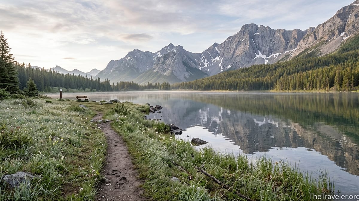
The Smith Dorrien Corridor: Quiet Lakes off a Gravel Road
South of Canmore, the Spray Lakes Road climbs steeply out of town and turns into the Smith Dorrien Trail, a long, mostly gravel route that threads through Spray Valley Provincial Park. Most rental car drivers stick to the main highways, so this corridor sees far fewer visitors than similarly scenic roads in Banff National Park. Those who are willing to drive a bit slower on gravel are rewarded with a chain of lakes, trailheads and viewpoints that still feel like open secrets.
One of the most accessible quiet stops is Watridge Lake, reached by a mostly flat forest road that begins near the Mount Shark trailhead. The wide path, originally laid out for cross-country skiing, makes for an easy walk or bike ride that families and less experienced hikers can manage in two to three hours round trip. At the lake, a simple shoreline offers space for a picnic, and anglers sometimes cast for cutthroat trout in the clear shallows. If you continue a short distance beyond the lake, a side path leads up to Karst Springs, where water blasts out of a hillside in a series of natural fountains.
Farther north along the Smith Dorrien, smaller pullouts lead to informal lakeside spots that many visitors never learn about. Locals launch paddleboards on calm summer evenings, watching the last light slide down the peaks and listening for loons. Because campground capacity in this corridor is limited compared to Banff, the human presence never reaches the same intensity, even in peak season. You may share the shoreline with a few other vehicles, but the atmosphere is closer to a long-weekend camping trip than a highway rest stop.
The character of the gravel road itself shapes the experience. Dust and washboard sections keep speeds down, and you will likely encounter wildlife along the margins: mule deer grazing in the ditches, a fox trotting across the road at dusk or, in lucky cases, a moose browsing in a marsh near the Spray Lakes Reservoir. These encounters underscore why the area remains less developed. It is a place where recreation fits around existing ecosystems rather than the other way around.
Highway 40’s Overlooked Viewpoints and Short Walks
Highway 40, which runs south from the Trans Canada through Kananaskis Country, is best known among locals as a gateway to serious hikes and ski tours. For many travelers, though, it is simply a blank line on the map between Calgary and the turnoffs for Banff. This oversight leaves several easily accessed viewpoints and short walks almost empty, even when the national park is packed.
Near the junction with the Trans Canada, Barrier Lake offers a classic mountain reservoir scene that many people only glimpse from their car window. A small day-use area at the north end of the lake has picnic tables and shoreline access, and a moderate trail climbs gradually to Prairie View and Yates Mountain for a high vantage point over the valley. Even if you do not tackle the full climb, walking a kilometer or two along the lakeshore in early morning or late afternoon can be rewarding. Low light picks out the striations in the surrounding peaks and, on calm days, reflections stretch almost unbroken across the water.
Farther south along Highway 40, pullouts near Opal Creek and other small drainages lead into quiet forests where informal paths follow the water. These are not headline destinations but opportunities to reset after a stretch of driving. You can park, listen to the sound of a small creek over stones, and scan the cutbanks for animal tracks in the damp sand. For families, these unstructured stops are often as memorable as formal attractions, precisely because there are no railings, ticket booths or interpretive displays competing for attention.
Because Highway 40 passes through sensitive wildlife habitat, including corridors for bears and elk, there are regular speed reductions, wildlife crossing signs and seasonal road closures, particularly near Highwood Pass. For travelers who value quieter experiences, these management steps are a benefit rather than an inconvenience. By limiting heavy traffic at key times, they help keep surrounding side valleys relatively undisturbed, so that you can still step out of your car in mid-summer and hear the drone of insects and the rush of unseen streams instead of a continuous line of engines.
Planning a Hidden Bow Valley Itinerary
The simplest way to work these quieter stops into a Bow Valley trip is to flip your thinking. Instead of starting with the big names and filling gaps with lesser known options, choose a base like Canmore or Kananaskis Village and build your days outward, treating the marquee sights as optional add ons. This shift not only reduces stress around parking, shuttles and reservations, it also increases your chances of spontaneous discovery.
Imagine a long weekend based in Canmore. On day one, arrive from Calgary and detour into Bow Valley Provincial Park for an hour-long loop at Middle Lake, followed by a picnic lunch. Check into your accommodation in Canmore in the afternoon, then stretch your legs on the Bow River pathway and Larch Island at dusk. On day two, drive the Smith Dorrien corridor to Watridge Lake and Karst Springs, with a leisurely coffee stop at a roadside viewpoint on the way back. Reserve day three for a canyon walk at Grotto Canyon or Jura Creek before rolling west into Banff townsite for a late lunch and a short wander. You still see the famous peaks, but the rhythm of your trip is anchored in quieter spaces.
Budget wise, these hidden stops can help keep costs reasonable. Most walks described here require no guiding fees, and once you have purchased the appropriate park permits and conservation pass, there are no additional entrance charges for each trailhead. In Canmore, vacation rentals and small inns can be more affordable than hotels in Banff, especially midweek or outside the peak season of late June through early September. Packing a simple picnic for lunches gives you the flexibility to eat beside a lake or river rather than relying entirely on restaurants.
Finally, traveling the quieter side of Bow Valley carries a measure of responsibility. Encounters with wildlife are more likely away from busy townsites, so it is important to carry bear spray where recommended, hike in small groups when possible and follow standard practices like making noise in dense forest and never feeding animals. Staying on established trails and respecting temporary closures helps keep these hidden places feeling wild, so they remain worth visiting in future years.
FAQ
Q1. Where is Bow Valley and how do I get to these quieter spots without a guide?
Bow Valley follows the Bow River between Calgary and the high Rockies, passing through Canmore, Banff and several provincial parks. You can reach most of the quieter locations mentioned here Middle Lake, Many Springs, Larch Island, Grotto Canyon, Watridge Lake and viewpoints along Highway 40 by regular rental car from Calgary, typically in one to two hours of driving, without needing a guide.
Q2. Do I need a special permit or pass to visit Bow Valley’s hidden areas?
Most trailheads in Kananaskis Country, including Bow Valley Provincial Park and the Smith Dorrien corridor, currently require a Kananaskis Conservation Pass tied to your vehicle plate. If you also plan to enter Banff National Park, you will need a separate Parks Canada pass for that portion of your itinerary. Both passes can be purchased in advance so you do not have to stop at a booth on arrival.
Q3. When is the best time of year to explore these less visited stops?
Late June through September offers the most reliable access to all of the locations in this article, with snow-free trails and long daylight hours. May and October can be beautiful shoulder seasons with fewer people, but higher elevation areas along the Smith Dorrien corridor and Highway 40 may still have snow or partial closures, so you should check recent reports and be prepared for cooler conditions.
Q4. Are these quieter trails suitable for families and less experienced hikers?
Many of the hidden stops described here are ideal for families and casual walkers. The loops at Middle Lake and Many Springs, the Bow River pathway and Larch Island in Canmore, and the approach to Watridge Lake follow relatively gentle terrain. Canyon walks like Grotto Canyon and Jura Creek involve uneven footing and creek crossings, so they suit active children and adults comfortable with basic scrambling and getting their feet wet.
Q5. How crowded are these places compared with Banff and Lake Louise?
Crowds vary by season and day of the week, but in general you can expect a fraction of the traffic you would encounter at major viewpoints in Banff National Park during peak summer. Trailheads in Bow Valley Provincial Park, the Smith Dorrien corridor and along Highway 40 often have parking available well into the day, and you are more likely to share the trail with local hikers and dog walkers than large tour groups.
Q6. What kind of wildlife might I see in these quieter parts of Bow Valley?
The valley’s mix of river, wetlands and forest supports diverse wildlife, including elk, deer, black bears, occasionally grizzly bears, beavers, and a wide range of birdlife from songbirds to raptors. Around Middle Lake and Many Springs you may spot waterfowl and wading birds, while the Bow River backwaters near Larch Island sometimes reveal beaver lodges and muskrat activity. Always observe animals from a distance and follow local safety guidelines.
Q7. Can I visit these areas in winter, or are they strictly summer destinations?
Many of the quieter spots remain accessible in winter and transform into excellent snowshoeing or winter walking routes, depending on conditions. Local hikers often explore Grotto Canyon on the frozen creek, walk the Bow River pathway in Canmore, or snowshoe to Watridge Lake from the Mount Shark trailhead. Winter travel requires extra care, including traction for your boots, warm layers and checking avalanche and weather advisories before heading out.
Q8. What gear should I bring if I want to explore beyond the standard tourist stops?
For most of these outings, sturdy footwear with good grip, a small daypack, layered clothing for rapidly changing mountain weather, a refillable water bottle and basic navigation tools such as a map app or offline map are sufficient. If you plan canyon or shoulder season hikes, pack lightweight waterproof footwear or sandals for creek crossings, and consider trekking poles for balance on uneven or icy terrain.
Q9. Is it realistic to explore these hidden areas using only public transportation or shuttles?
Public transportation in Bow Valley primarily links Calgary with Canmore and Banff and serves a few popular national park destinations. The more obscure trailheads in Bow Valley Provincial Park, along the Smith Dorrien corridor and on Highway 40 generally do not have regular transit or shuttle service, so renting a car or joining a small local tour that targets less visited spots is usually the most practical approach.
Q10. How can I minimize my environmental impact while visiting these quieter places?
You can reduce your impact by staying on established trails, packing out all trash, using existing toilets or outhouses where available and keeping group sizes modest. Avoid approaching or feeding wildlife, respect temporary area closures and choose refillable bottles and reusable containers rather than single-use packaging. When possible, combine several stops into a single driving loop so you spend less time on the road and more time on foot.