


Dettifoss is not hard to reach if you understand the road layout. Confusion usually comes from the road numbers, seasonal closures and conflicting advice. This guide strips it back to the essentials so you can choose the right side of the canyon, drive there confidently and avoid backtracking on rough or closed roads.
Get the latest updates straight to your inbox!
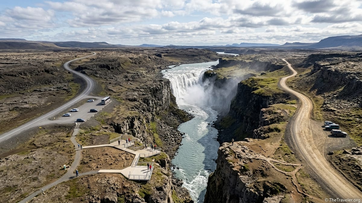
Understanding Dettifoss and Its Two Approach Roads
Dettifoss lies in Northeast Iceland within Vatnajökull National Park, roughly between Lake Mývatn to the southwest and Ásbyrgi canyon and the coastal town of Húsavík to the north. It sits inside the Jökulsárgljúfur section of the park, carved by the glacial river Jökulsá á Fjöllum. For drivers, the crucial point is that the waterfall can be approached from both banks of the canyon, using two different numbered roads.
On the west bank runs Route 862, often referred to locally as Dettifossvegur. This road now forms part of the paved Diamond Circle sightseeing loop in North Iceland and is the primary access for most visitors. On the east bank is Route 864, a gravel road that follows the canyon more closely and links the Ring Road area with Dettifoss and the northern Jökulsárgljúfur sites when open in summer conditions.
Each road has its own character. Route 862 is paved, generally more comfortable and better suited to typical small rental cars in normal summer weather. Route 864 is unpaved, can be slow and bumpy, and is usually treated as a summer-only option. Switching from one side of the canyon to the other is not a quick hop but requires a substantial detour via the Ring Road or coastal routes, so it is important to choose your side before you set off.
Both roads and the spur routes that lead to the parking areas are subject to Iceland’s rapidly changing conditions. Drivers should treat any description of typical access as guidance only and confirm the current situation through official road and park information on the morning of their visit.
Route 862: Main West‑Side Access on Paved Dettifossvegur
Route 862 on the west bank is now fully paved between the Ring Road and the north, forming a key part of the Diamond Circle touring route. It connects with Route 1 south of Dettifoss near the Mývatn area and with the northern roads leading toward Ásbyrgi and Húsavík. This upgrade replaced the old gravel Dettifoss track and turned 862 into the default choice for tour buses and most independent travelers in the main season.
From the Ring Road, signage directs you onto 862 toward Dettifoss. From the north, you can approach along the same road coming south from Ásbyrgi or the junctions serving Húsavík. In both directions the driving experience is broadly similar: a two-lane paved road through open highland scenery, exposed to wind and weather but much smoother than any gravel alternative.
A short spur leads from Route 862 to the west-side Dettifoss parking area. On many maps this spur is shown with its own number, such as 886, and its status may not always match the main 862. It can sometimes open later in spring or close earlier in autumn than the through road if snow, ice or mud make the last stretch unsafe. Drivers should therefore check not only the condition of 862 but also the specific access road to the car park using the latest information from the national road authority.
In typical summer conditions, any standard two-wheel-drive rental car is considered suitable for Route 862. However, conditions can deteriorate quickly in rain, snow or strong winds, especially outside high summer. Paved does not mean harmless. In shoulder seasons and winter, expect patches of ice, slush or compacted snow and drive well below the posted speed limit, watching for warnings about slippery surfaces.
Route 864: Rougher East‑Side Gravel, Usually Summer‑Only
Route 864 runs along the east side of the Jökulsárgljúfur canyon, giving access to Dettifoss from the opposite bank. Unlike Route 862, it is an unpaved gravel road along its length. Visitors consistently describe it as rougher, with potholes, washboard ripples and sections that can become muddy or rutted after rain. The road passes other viewpoints in the canyon and eventually links the Ring Road area in the south with the northern approach toward Ásbyrgi and the coast.
Official and regional tourism information describe Route 864 as a road that is normally open only in summer. It does not receive routine snow clearance in winter, and its opening in spring is tied to both snowmelt and the time it takes for the surface to dry out and be graded. In practice this means the opening date moves each year and can fall anywhere from late spring into early summer, depending on the season. Likewise, autumn closures can come sooner in years with early snow or prolonged wet weather.
Because of its surface and lack of winter maintenance, Route 864 is not recommended for nervous drivers or for those traveling in poor weather, even if they have a legal right to drive it in a small two-wheel-drive vehicle. A higher-clearance car or a driver experienced on gravel will find the road less stressful. Rental companies regularly report gravel damage as a common insurance claim in Iceland, and 864 is a classic example of the type of road where this can happen.
Conditions on 864 can change significantly from one week to the next as traffic, rain and grading all alter the surface. Reports from previous years are not a reliable guide to how the road will feel when you visit. Treat any anecdotal description as general background and base your go or no-go decision on current road condition updates and local advice on the day.
Distances, Driving Times and Common Starting Points
Most visitors reach Dettifoss while touring North Iceland, often combining it with Mývatn, Húsavík, Ásbyrgi or a longer Ring Road journey. Distances and driving times below are based on current digital maps and should be treated as approximate. They should be checked again against up-to-date mapping tools when planning a specific trip or before publication.
From the Mývatn area, using Route 1 and then Route 862 to the west-side parking, the drive is roughly one hour in normal summer conditions, depending on your exact starting point around the lake. The east-side approach via Route 864 is of similar overall distance but slower because of gravel, so plan extra time if you choose that route and avoid tight same-day schedules.
From Akureyri, most drivers follow the Ring Road east and then turn onto Route 862 to reach the west bank, with a total driving time often quoted at around two to two and a half hours in good conditions. From Húsavík, Dettifoss can be included on a Diamond Circle circuit by taking the northern roads toward Ásbyrgi and connecting with Route 862 from the north, again allowing in the region of two hours of driving to the falls depending on stops.
From Egilsstaðir and the Eastfjords, the usual approach is along the Ring Road heading northwest before turning off either to Route 862 for the west bank or, in suitable summer conditions, to Route 864 for the east bank. This is a substantially longer drive that can easily exceed three hours, so travelers coming from the east often plan Dettifoss as a major stop rather than a quick detour. Whatever your starting point, remember that poor weather and slow surfaces can extend these times significantly.
Navigating With GPS and Choosing the Correct Side
One of the most common sources of confusion around Dettifoss is digital navigation. Some GPS devices and mapping apps still default to directing drivers along the east-side Route 864, either because it appears slightly shorter or because historical routing data has not prioritized the newer paved west-side road. This can be problematic for visitors in small rental cars or outside the main summer season.
To avoid unpleasant surprises, decide in advance which side you want to visit. If you prefer the smoother drive, more reliable access and more developed facilities, explicitly set your device to navigate to the west-side parking off Route 862. Make sure it is routing via 862 rather than 864 and double-check the route overview before you start driving. If you are deliberately seeking the east bank for a different view and are traveling in suitable summer conditions, then confirm that your GPS is indeed using 864 and that the road is open.
Switching between sides of the canyon is not a quick fix once you are committed. There is no bridge at Dettifoss, so to change banks you must return to the Ring Road or use the northern coastal roads and then drive in again on the other side. This can add a substantial amount of driving time. Drivers should not plan to sample both banks on a tight schedule unless they have carefully mapped the total detour involved and allowed a generous buffer for conditions.
If your navigation system and roadside signs appear to conflict, always give more weight to the official traffic signs and to current road status information rather than blindly following a device. In North Iceland, small differences in route choice can mean the difference between a clear paved road and a closed gravel track.
Parking Areas, Facilities and Paths to the Viewpoints
On the west bank, a main parking area serves Dettifoss and the nearby Selfoss viewpoint. It is reached by the spur road from Route 862 and is the standard arrival point for most independent travelers and tour buses. The surface is typically compacted gravel or similar, suitable for ordinary vehicles in normal conditions. According to regional visitor information, toilets are available at this west-side car park and are described as being open throughout the year, although short closures for maintenance or extreme weather can occur.
On the east bank, smaller parking areas provide access to viewpoints over Dettifoss and to other parts of the canyon when Route 864 is open. Facilities here are usually simpler than on the west side, and travelers should not count on year-round toilets or services. The emphasis is on more rugged viewpoints rather than built infrastructure, and conditions can feel more remote even though you are still relatively close to the Ring Road network.
From both west and east parking areas, access to the waterfall is on foot along marked paths. These routes cross uneven natural terrain that can include rock slabs, loose stones, exposed sections and in places steps or stairways. Surfaces may be wet, muddy, icy or snowy depending on the season. Even in summer, sturdy footwear is advisable and visitors with limited mobility may find the approach challenging.
The exact layout of paths, viewing platforms and any safety barriers can change as the national park upgrades infrastructure or carries out erosion control. Before describing specific walk durations or platform designs, writers should check the latest information from Vatnajökull National Park and local tourism sources to confirm what is currently in place and whether any viewpoints or trails are closed.
Winter and Shoulder Seasons: What to Expect
In winter and the shoulder seasons of late autumn and early spring, the balance between the two approach roads changes sharply. Route 864 on the east bank is generally closed once snow accumulates and receives no routine snow clearance. It effectively drops out of consideration for ordinary visitors during this period, apart from specialized super jeep tours.
Route 862 on the west bank is treated as the main access toward Dettifoss, but even here winter service has limits. Recent guidance from local sources explains that parts of 862 receive reduced maintenance in the coldest months, and from deep winter onwards snow clearance may be less frequent or provided only on request. In storms or during heavy snow, sections can still be marked impassable, and short-term closures are not uncommon.
Because of this variability, travelers planning a winter Dettifoss visit must avoid relying on guidebook statements such as “accessible all year” without context. Conditions can differ dramatically from one week to the next. The only reliable approach is to check the official road condition system and updated park reports on the same morning you plan to drive, and to be prepared to change your plan if either approach is closed or flagged as hazardous.
Even when Route 862 is open, expect winter driving challenges such as packed snow, ice, drifting and reduced visibility. Strong winds on the plateau can produce ground blizzards that make the road effectively invisible at times. In these seasons, slower speeds, earlier start times and a willingness to turn back are key parts of a responsible plan, especially for visitors unused to Icelandic winter roads.
Key Comparisons: Route 862 vs Route 864
Writers preparing a simple comparison table should summarize Route 862 and Route 864 using only verified, up-to-date details. For surface type, Route 862 can be described as a paved road along the west bank forming part of the Diamond Circle, while Route 864 remains an unpaved gravel road on the east bank. Under typical season, Route 862 should be noted as generally usable in the main travel season with limited or variable winter service, and Route 864 as usually a summer-only road that closes once autumn conditions deteriorate.
On suitability for small two-wheel-drive rental cars, Route 862 is commonly used by such vehicles in summer and is the standard choice for regular tour coaches and minibuses. Route 864, while legally passable to non-four-wheel-drive vehicles when open, is rougher and better suited to higher-clearance cars and confident gravel drivers. Any table should make clear that suitability depends on actual conditions on the day, not just vehicle type.
Regarding access to other viewpoints, the west-side area off Route 862 offers path access to both Dettifoss and Selfoss. Hafragilsfoss viewpoints are typically accessed from separate parking areas that may be easier to reach from the east bank in summer via 864, although details should be checked against current park information before publication. Toilets are reported at the main west-side Dettifoss car park, with no equivalent year-round facilities confirmed for the east side.
In the Diamond Circle column of such a table, Route 862 should be clearly identified as part of the standard paved Diamond Circle circuit linking Húsavík, Ásbyrgi, Dettifoss and Mývatn. Route 864 is better described as an alternative summer gravel link along the canyon rather than a core part of the main loop. Throughout the comparison, language should remain cautious, highlighting that specific opening dates, maintenance priorities and facilities must always be verified with current sources.
Practical Recommendations for Different Travelers
For time-limited visitors passing through North Iceland on a single day, the west-side access via Route 862 is usually the most practical choice. The paved surface, clearer signage and more developed parking and paths reduce the risk of delays and allow more predictable timing when you are trying to combine Dettifoss with Mývatn, Húsavík or a long Ring Road drive. Even so, travelers should leave generous time for the walking approach and for slower speeds if weather worsens.
Cautious drivers, especially those unused to gravel or to Icelandic weather, are likewise generally better served by Route 862 in summer and by deferring Dettifoss in winter if conditions or road reports look marginal. Choosing the paved option lowers the stress of the journey, particularly for those in small city-style rental cars or families who want to minimize uncomfortable driving while still enjoying the waterfall.
Travelers who prioritize variety of views over road comfort, and who visit in settled summer weather with a suitable vehicle, may choose Route 864 for its different perspective on Dettifoss and the canyon. For them, the key is to treat the gravel driving time realistically, understand that surfaces can be rough and slow, and build their itinerary around a full day in the Jökulsárgljúfur area rather than attempting to rush through.
For those visiting in deep winter, the most realistic plan is often to focus on other accessible North Iceland sights and treat Dettifoss as an optional extra that is only added if Route 862 and the access spur are both clearly open and safe on the day. Across all traveler types, the same principle holds: decide your side in advance, confirm road and weather conditions immediately before departure, and be ready to adapt if Iceland’s elements dictate a different plan.