
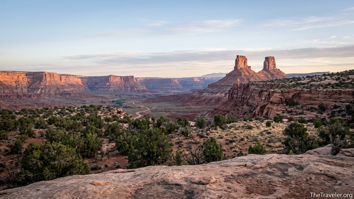
Bears Ears National Monument in southeast Utah looks simple on a map: a sea of red rock canyons, lonely mesas and a scattering of dirt roads between Moab, Blanding and Bluff. On the ground, it is anything but simple. This is a remote, sacred landscape co-managed with Native nations, with few services, confusing regulations and backroads that turn risky the moment it rains. Travelers who arrive treating Bears Ears like just another national park are often surprised by how different it feels. Understanding those differences before you go can mean the difference between a transformative trip and a stressful one.
Get the latest updates straight to your inbox!
Understand Where You Are: A Living Native Homeland, Not Just a Scenic Monument
The single most important thing most first-time visitors to Bears Ears wish they had fully grasped is that this is not just a playground of canyons and rock towers. Bears Ears is a living cultural landscape and ancestral homeland for at least five Native nations, including the Navajo Nation, Hopi, Ute Mountain Ute, Ute Indian Tribe and Pueblo of Zuni. Tribal members still gather plants, visit shrines, conduct ceremonies and hunt here. The ancient dwellings and rock art that seem like “ruins” to visitors are, in many cases, the homes and places of worship of people whose descendants are still very much alive.
That reality affects the tone of your visit. Many travelers describe arriving with a national parks mindset, eager to “see the sights,” and realizing only after a ranger talk at the Kane Gulch Ranger Station or Edge of the Cedars Museum in Blanding that they are moving through places others regard as sacred. It is common to hear people say they wish they had listened to podcasts, read tribally produced guides or visited a cultural center before heading down the first canyon. Doing that homework shifts your focus from “collecting” ruins and rock art photos to quietly experiencing the landscape and its stories.
In practice, this means following local guidance like “Visit With Respect,” a set of principles emphasized by the Bureau of Land Management and tribal partners. You keep a respectful distance from dwellings and kivas, never enter rooms or climb on walls, and you photograph without rearranging artifacts or posing on structures. Travelers who arrive already thinking this way tend to feel far less conflicted when they encounter delicate sites sitting unguarded on a ledge or tucked into a sandstone alcove.
It also helps to understand that management is shared. Bears Ears is overseen by the Bureau of Land Management and the U.S. Forest Service working with a Bears Ears Commission representing tribal governments. That co-management model is relatively new and still evolving. Practical details, from where drones are allowed to how climbing routes near petroglyphs are managed, can change faster than a printed guidebook. Checking current advice from land managers and, where possible, tribally run visitor centers just before your trip is essential.
Permits, Fees and Rules: Bears Ears Is Not One Uniform Set of Regulations
Another surprise for many visitors is how patchwork the permit system feels. There is no entrance station or monument-wide fee. You can drive the dirt road loop through Valley of the Gods or the paved road along Indian Creek without ever flashing a pass. Yet the moment you shoulder a pack into certain canyons or launch a raft on sections of the San Juan River, permits and fees apply, and rangers do check them.
The biggest trap for new visitors is Cedar Mesa and Grand Gulch. Backpacking in canyons such as Kane Gulch, Bullet Canyon, Fish and Owl, Slickhorn and the forks of Mule Canyon requires an advance permit and daily or nightly fees managed through Recreation.gov and the BLM. Day hiking in some high-use areas also has a per-person fee that you pay either online or at self-serve kiosks. Travelers who show up in March or April assuming it works like a national park day hike are often disappointed to find quota days fully booked or cash-only self-pay stations at trailheads when they are carrying only cards.
At the same time, car camping away from those fee areas is often free, provided you use existing disturbed sites along designated roads and follow fire and waste rules. For example, pullouts along the Valley of the Gods loop and dispersed sites on some BLM roads off Highway 211 near Indian Creek are popular with vanlifers and tent campers looking for no-fee options, while small developed campgrounds like Hamburger Rock and Creek Pasture near Indian Creek charge a modest nightly fee per site. The contrast between free pullouts and reservation-only campgrounds a few miles apart can be confusing if you have not checked in advance where fees apply.
Rules also differ between agencies. One hillside may be national forest, another BLM land, and a nearby canyon managed partly under special rules to protect cliff dwellings. Drone regulations illustrate this well. In much of Bears Ears, drones are either prohibited outright or tightly restricted near cultural sites and certain wildlife areas, and separate rules may apply if you cross an invisible boundary into a national park or other federal unit. Climbers visiting Indian Creek, one of the world’s great crack-climbing destinations, find that some routes or walls near petroglyph panels have closures or seasonal restrictions designed to protect cultural and natural resources. Veterans of the area suggest treating every new canyon or mesa as if the rules might be slightly different and verifying ahead of time instead of relying on what was allowed where you camped the previous night.
Roads, Weather and Navigation: Remote Really Means Remote
On mapping apps, Bears Ears can look comfortably threaded with roads: State Route 211 running out to Canyonlands, paved stretches near Bluff and Blanding, and a web of faint lines labeled “jeep road” across Cedar Mesa and the Elk Ridge country. On the ground, people are regularly surprised by how quickly those lines turn into rough two-tracks where deep sand, rock ledges and unmarked junctions make travel slow. A compact rental car can usually handle the graded main access roads in dry weather, but many spur roads and mesa-top tracks are better suited to high-clearance vehicles, and even then only when conditions are dry.
Rain and snow are the biggest wild cards. A passing storm can turn hard-packed clay into a slick, sticky mess that defeats all-wheel-drive crossovers and leaves deep ruts when impatient drivers push through. Visitors often recall trips where a quiet morning at a campsite off Butler Wash was followed by an afternoon cloudburst that stranded them for a day because the only way back to pavement was through gumbo. In winter and early spring, snow can linger on the higher roads that climb toward the namesake Bears Ears buttes and the Abajo Mountains, closing off routes that looked straightforward on satellite imagery.
Navigation surprises people in a different way. Unlike many national parks, Bears Ears has few built trails and almost no wayfinding signs once you leave a parking area. Popular routes into canyons such as Grand Gulch are often a patchwork of braided footpaths, cairns and sandy washes rather than a single, clearly marked trail. In places where archeological sites are clustered, managers have deliberately kept signage minimal to reduce vandalism and looting. Hikers who arrive expecting well-marked loops frequently find themselves cross-checking paper maps, GPS apps and route descriptions from guidebooks to be sure they are in the right side canyon.
Because of that, seasoned visitors insist on redundancies. Many carry a printed topographic map or an atlas of the region in addition to an offline navigation app. They download maps for the entire monument, not just a single canyon, in case weather or road conditions force a last-minute change of plan. And they plan driving days more conservatively than in most destinations: two hours on the map may realistically take three or four when you factor in slow washboard roads, photo stops and the need to backtrack if a washout or snowbank blocks the way ahead.
Camping, Water and Waste: Desert Logistics That Catch People Off Guard
Travelers who are used to national park campgrounds with flush toilets and potable water often find Bears Ears surprisingly barebones. Developed campgrounds are concentrated in a few pockets such as Indian Creek, where small BLM campgrounds like Hamburger Rock, Superbowl and Creek Pasture offer picnic tables, fire rings and vault toilets for a low nightly fee, but no hookups or showers. In the Bluff and Blanding corridor on the monument’s southern edge, private campgrounds and basic motels fill in some of those gaps, yet once you head onto the mesas or into the deep canyons you should not expect spigots or bathhouses.
Free dispersed camping is a major draw, but it comes with responsibilities. In many parts of the monument you are allowed to camp along dirt roads as long as you use existing disturbed sites instead of creating new clearings or fire rings. Veteran visitors recommend looking for previously used pads on durable surfaces like gravel or slickrock rather than fragile biological soil crust. Using a portable toilet or wag bags is increasingly encouraged, especially in popular corridors like Butler Wash or on the mesa tops above Grand Gulch, where shallow desert soils do a poor job of breaking down human waste.
Water is perhaps the biggest shock for newcomers. Streams in canyons like Kane Gulch or Owl Canyon can run dry for long stretches, especially by late summer or during dry years, and reliable springs may be miles apart. The Kane Gulch Ranger Station often posts seasonal water reports for backpackers, but even those come with warnings that conditions change quickly. Backpackers who are used to carrying a single filter bottle and topping up every couple of miles in alpine areas are often surprised to find themselves hauling several liters for long dry segments and still budgeting time for detours down side canyons to check for potholes and seeps.
Fire restrictions are another detail that catches some travelers off guard. In a typical high-use season, managers may ban campfires in certain canyons or across the monument due to wildfire risk. Even when fires are allowed, you are expected to use existing metal fire rings or rock rings, keep fires small, and pack out all foil, wire and food scraps. Many regulars simply rely on backpacking stoves for all their cooking and skip campfires entirely, both to reduce impact and to avoid the hassle of gathering limited downed wood in sparse desert vegetation.
How to Visit Sites and Rock Art With Real Respect
If there is one thing almost everyone who loves Bears Ears agrees on, it is that the cultural sites feel uniquely vulnerable. Pictograph panels, handprints and petroglyphs often stand unprotected on canyon walls within arm’s reach of a day-use parking area. Masonry granaries and dwellings perch in alcoves that can sometimes be reached in a few minutes off the main route. Travelers often recount how thrilling it felt to climb a slickrock ramp and suddenly find themselves eye-level with an 800-year-old doorway, followed by an uneasy realization that a stray boot-print or casual lean could do real damage.
The most important behaviors are also the simplest. You never touch rock art, even lightly, because the oils and sweat from your skin can permanently darken pigment or contribute to flaking. You do not sit or stand in doorways, lean on walls or climb into rooms, because even apparently solid stonework can be weakened by vibrations or hairline cracks. Where artifacts like pottery sherds or corncobs remain on the ground, you admire them in place instead of stacking them, arranging them for photos or pocketing a “souvenir.”
Responsible visitors also keep their exact route details and GPS coordinates vague when sharing online. Longtime guides and former rangers in the area point out that a wave of geotagged photos and step-by-step directions can overwhelm fragile sites that lack the staffing and infrastructure of major parks. Instead of posting specific alcove names and waypoints, they might refer more generally to “a side canyon off Grand Gulch” or “a panel in the Butler Wash area,” encouraging others to do their own research through official channels and printed guidebooks.
Noise and crowding are part of respect too. Many canyons and mesas in Bears Ears are used for ongoing ceremonies or personal pilgrimage. Arriving at a rock art panel with a loud Bluetooth speaker or shouting back and forth in a narrow canyon changes the experience not only for wildlife, but for visitors seeking a quieter, more reflective connection to the place. Travelers who consciously lower their voices, keep group sizes modest on sensitive routes, and build in time to simply sit and listen often say that the landscape feels different: less like a gallery of artifacts and more like a living, breathing homeland.
Seasonal Timing, Nearby Gateways and Realistic Itineraries
Bears Ears can be visited year-round, but the experience changes dramatically with the seasons, and many travelers say they underestimated how extreme that swing can feel. Spring and fall, roughly March through May and late September through early November, are generally the sweet spots: days are cool to warm, nights are chilly, and water is more likely in canyon pools. These windows are also the most popular for Cedar Mesa backpacking permits and Indian Creek climbing, so planning months ahead for specific routes or campsites is wise.
Summer can be far more demanding than it looks from a distance. Daytime temperatures on exposed slickrock and mesa tops often soar, and many canyon bottoms offer only intermittent shade. Hikers recall feeling surprisingly drained just walking short distances from a roadside ruin to a viewpoint in July, especially when the air is still and there is little evaporative cooling. Monsoon thunderstorms that typically build in late summer add lightning, flash flood risk and sudden downpours that can strand vehicles on clay roads or turn dry washes into brief torrents. Early starts, long siestas and backup plans that keep you out of narrow slots during stormy afternoons are crucial.
Winter brings its own rewards: low-angle light, uncrowded trails and a better chance of solitude at well-known panels and alcoves. But snow and ice linger at higher elevations near the Bears Ears buttes and the Abajo Mountains, and overnight lows can plunge well below freezing, especially in the shadowed canyons. Visitors who try to string together a loop from Bluff to the high country and back in January sometimes discover that a road that was dusty two months earlier is now drifted in or closed by seasonal gates.
Gateway towns matter more than many people expect. Bluff and Blanding on the south side of the monument, and Monticello to the north, are where you will find groceries, fuel, basic gear, laundromats and the most current local word on road conditions. For example, a motel owner in Bluff or a clerk at a gas station in Blanding is often the first to hear that a popular canyon road washed out over the weekend. Moab, while not in the monument, serves as a practical base for exploring the Indian Creek section of Bears Ears, especially for climbers who may want a mix of remote camping and in-town rest days.
The Takeaway
More than most destinations in the American West, Bears Ears rewards travelers who slow down and arrive informed. This is not a drive-through photo stop or a checklist of famous arches to tick off in a day. It is a large, complex landscape where road conditions change with the weather, water can be scarce, and the most striking places are also some of the most culturally sensitive.
Visitors who speak most fondly of their time here tend to have a few things in common. They build itineraries around a small number of canyons or mesas rather than racing across the entire monument in three days. They spend time in gateway towns learning from local museums, tribal guides or rangers before heading into the backcountry. They assume that permits and rules may be different in each area and check for updates instead of relying on old trip reports.
If you approach Bears Ears as a guest in someone else’s home, the choices you make begin to look different: where you step, how loud you are, what you share online, and how carefully you plan for desert realities like thin water, cold nights and impassable clay roads. The reward for that extra care is a depth of experience that is increasingly rare in the modern travel world: nights under dark, unlit skies, mornings weaving through canyons where history is written on the walls, and the knowledge that you helped keep a fragile, sacred place a little wilder and more intact for those who come after you.
FAQ
Q1. Do I need a permit just to drive through Bears Ears National Monument?
In most cases you do not need a permit or to pay a fee simply to drive paved or main graded roads, but specific activities like backpacking in Cedar Mesa canyons or floating the San Juan River do require permits and advance reservations.
Q2. Is Bears Ears suitable for a standard rental car?
Main highways and primary access roads are usually passable in a standard car when dry, but many spur roads and mesa-top tracks require high clearance, and any unpaved road can become treacherous after rain or snow, so you should always check conditions locally before venturing off pavement.
Q3. Can I visit cliff dwellings and rock art sites up close?
You can often walk near dwellings and rock art panels, but you are expected to stay off walls and out of rooms, never touch rock art or artifacts, and follow all posted closures or distance guidelines, treating each site as if it were still someone’s home.
Q4. Are drones allowed in Bears Ears?
Drone use is heavily restricted and in many parts of the monument effectively prohibited, especially near cultural sites, wildlife areas and in zones where different agencies’ rules overlap, so you should assume drones are not allowed unless you have checked the current regulations for the exact area you plan to visit.
Q5. When is the best time of year to visit Bears Ears?
Most travelers find spring and fall offer the best balance of moderate temperatures, more reliable water in canyons and safer road conditions, while summer can be extremely hot with monsoon storms and winter can bring snow, ice and very cold nights, particularly at higher elevations.
Q6. Is there cell service and emergency help inside the monument?
Cell coverage is spotty to nonexistent across much of Bears Ears, and you should not depend on being able to call for help; instead, plan trips conservatively, leave your route with someone at home and consider carrying satellite communication for emergencies.
Q7. How do I find legal dispersed camping areas?
Legal dispersed camping is generally allowed in previously used sites along designated dirt roads outside fee areas, but specific rules and closures apply, so your best bet is to check recent maps and ask at local ranger stations or visitor centers before choosing a site.
Q8. Can I bring my dog to Bears Ears?
Dogs are allowed in many parts of the monument but must be under control, kept away from archeological sites and rock art, and you are responsible for packing out waste and respecting any area-specific leash or closure rules that protect wildlife and cultural resources.
Q9. How much time should I plan for a first visit?
While you can get a scenic taste of Bears Ears in a day or two, many visitors recommend at least three to five days to experience a mix of canyon hikes, mesa-top viewpoints and cultural sites without rushing or driving long distances every day.
Q10. Are guided trips or Native-led tours available?
Yes, a number of outfitters and tribally affiliated guides based in nearby communities offer hiking, rafting and cultural interpretation in and around Bears Ears, and many travelers feel that joining at least one guided outing greatly deepens their understanding of the landscape and its living Indigenous connections.