
I thought I knew New York City. I had done the usual loop: Times Square, Midtown towers, a quick dash through Central Park. It was only when I spent a full day on foot in Lower Manhattan, moving at the city’s walking pace rather than its subway speed, that the place came into focus. Street by street, from Battery Park to Chinatown, the island’s southern tip rewired how I understood New York itself.
Get the latest updates straight to your inbox!
Starting at the Water’s Edge: Battery Park and the Harbor
The shift began at the literal edge of the island. Standing in Battery Park, with ferries shuttling to Staten Island and the Statue of Liberty facing the harbor’s wide, choppy water, I could see why New York grew from this point. The skyline behind me was dense and vertical; in front of me, the view was open and horizontal, filled with container ships and commuter boats. It was the first reminder that New York is still a port before it is a postcard.
Walking north from the ferry terminal, past the clusters of visitors in line for Liberty Island and Ellis Island boats, the city felt almost small. Office workers cut diagonally across the lawns instead of following the paths, making their own desire lines in the grass. A coffee from a kiosk in the park cost only slightly more than at a neighborhood cafe uptown, and people drank it while looking outward, not up, scanning the harbor for weather and waves the way people in other cities scan traffic.
On a weekday morning, Battery Park is where New York feels least like an abstract financial capital and most like a working waterfront. Maintenance crews maneuver small utility carts, park rangers answer practical questions about ferry schedules, and runners trace the promenade that wraps the southern tip of Manhattan. The rhythm here is tidal rather than transactional. Before I set off inland, it struck me that the city’s story was written from this shoreline backward, not from Midtown down.
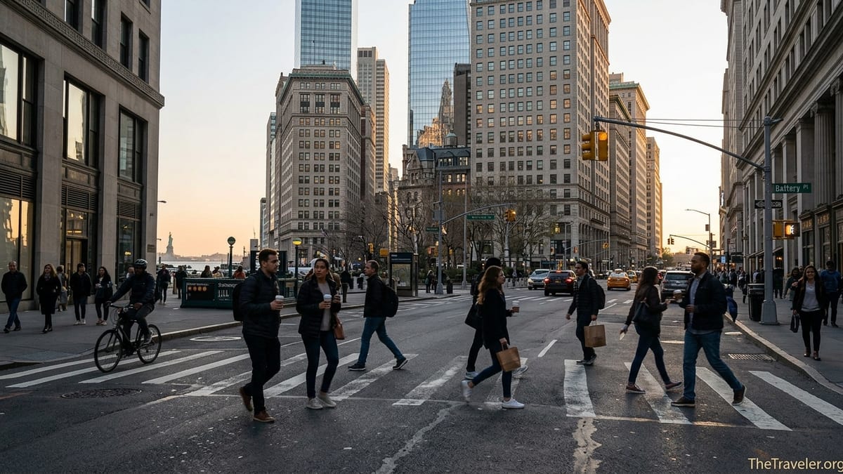
Broadway: A Colonial Path Turned Urban Spine
Leaving the park, I followed Broadway north, the same route that once connected the Dutch colonial settlement of New Amsterdam to points further up the island. Here the grid that defines much of Manhattan does not apply; the street bends and tilts, widening into small triangular plazas and narrowing into tight lanes that seem to press pedestrians toward the middle. You feel the weight of centuries under your feet in a way you rarely do in Midtown.
At Bowling Green, New York’s oldest public park, office workers share benches with visitors clutching paper maps and smartphone screens. The famous Charging Bull sculpture, fenced by a loose ring of people angling for photos, sits in the middle of what is functionally a busy traffic island. It is one of Lower Manhattan’s few fully theatrical moments, yet even here you can see everyday life pushing through: bike couriers weaving past, a flower vendor re-stocking buckets, a pair of kids in school uniforms rushing toward the subway entrance on Whitehall Street.
Continuing up Broadway toward Wall Street, the glass of bank headquarters reflects older stone facades, and it becomes obvious that New York is not a single skyline but overlapping eras. A coffee cart on a corner offers a small lesson in local economics. A basic drip coffee might run around two dollars, far less than the craft brew in a sleek cafe just up the block, yet regulars line up for the cart. That contrast between polished finance and practical street-level life is what keeps Lower Manhattan from feeling like an open-air trading floor.
The Canyon of Capital: Wall Street, Broad Street, and the Quiet After Hours
Turning off Broadway onto Wall Street is like stepping into an urban canyon. The towers close in, the light narrows, and sound behaves differently, echoing against the stone and glass. During trading hours, Broad Street outside the New York Stock Exchange holds a dense mix of suited employees, delivery drivers, security barriers, and souvenir sellers. It is one of the few parts of Manhattan where you can stand and hear conversations in several languages within a few square meters, all focused on money in one way or another.
Yet it was in the off-hours, in the early evening, that Wall Street changed how I understood New York. As the trading day ended, the suits disappeared, and the streets did not turn into an entertainment district. Instead, they became almost village-like. Dog walkers appeared. Residents carrying grocery bags cut confidently across streets that tourists took slowly, scanning every cornice and inscription. A pizza slice from a small Broad Street shop, sold for a few dollars on a paper plate, tasted notably better eaten on the steps of a stone facade than at a standing counter.
Walking east toward Water Street and the East River, you sense how finance is only one layer of this district. Old stone churches and modest brick buildings survive between towers, and many have been converted into small hotels, apartments, and convenience stores. The people emerging from these doors at dusk are not visiting for a few hours of sightseeing; they live here. That everyday residential life, tucked into the same blocks as global markets, complicates the popular image of Wall Street as a sealed zone.
Fulton Street and the Seaport: From Working Piers to Leisure Waterfront
Further east, Fulton Street shifts the city’s mood again. As it runs from near the World Trade Center down to the East River, portions of the street are now closed to cars, turning what were once vehicle lanes into open pedestrian space. West of Broadway, commuters stream out of subway entrances beneath the rebuilt towers at the World Trade Center site, moving toward office towers, discount retailers, and sandwich chains. East of Water Street, the same street name leads you toward the South Street Seaport and a very different expression of the waterfront.
The Seaport area emphasizes brick warehouses, cobblestones underfoot, and views of the Brooklyn Bridge framed by rigging masts. A visit here shows how the city has repurposed its working piers into leisure districts without entirely erasing history. You can tour historic ships, step into the small maritime museum, and then eat at modern restaurants where a waterfront lunch might cost three or four times what a takeout meal would cost on nearby John Street. Both experiences are equally “New York,” just calibrated for different audiences and budgets.
What struck me most walking around the Seaport was how casual this part of Lower Manhattan feels compared with its financial core only a few blocks away. Families push strollers across pedestrian-only blocks, teenagers sit on the edge of piers scrolling their phones, and office workers drift in after hours for happy hour drinks overlooking the East River. The sounds here are less about horns and sirens and more about buskers, seagulls, and snippets of music from open bar doors. It is the same city, given back to people rather than trucks and loading docks.
Streets That Refuse the Grid: Getting Lost on Purpose
One of the surprises of walking Lower Manhattan is discovering how disorienting it can be. Unlike Midtown’s predictable avenues and numbered streets, this district’s layout follows old paths, property lines, and shorelines long since filled in. Streets such as Pearl, Beaver, and Stone twist and end abruptly, creating small triangular plazas and unexpected perspectives. More than once, following a narrow passage that felt like an alley brought me out onto a bustling arterial road.
This irregular street pattern turns Lower Manhattan into a kind of urban classroom. Every unexpected jog or dead-end reveals how the city grew incrementally, plot by plot, rather than as a single engineered plan. Consider a short walk from Broadway to the East River: in less than ten minutes you might cross plazas with outdoor art, slip down a narrow block flanked by early 20th-century facades, and emerge beside modern glass office towers. In the span of a few hundred meters, architectural styles and street widths cycle rapidly, a physical lesson in economic booms, fires, and zoning shifts.
For a traveler, getting deliberately a little lost here is instructive. You learn, for instance, that a quiet side street only one block from a major tourist route can host a modest diner where breakfast costs only slightly more than in a residential borough, and you can hear local gossip over eggs and coffee. You realize that many of the city’s most atmospheric corners are where the grid breaks down, allowing human-sized spaces to persist in a city famous for its vertical scale.
World Trade Center to City Hall: Memory, Green Space, and Movement
No walk through Lower Manhattan is complete without passing the World Trade Center site. The memorial pools, set into the footprints of the original twin towers, reframe the usual New York soundtrack. Waterfall noise softens city sounds, and people instinctively lower their voices. Walking the perimeter, reading names engraved in bronze, you sense how national narratives attach themselves to specific urban spaces. It is not just a memorial but a daily path to work and transit for thousands of people.
From there, heading northeast toward City Hall Park, you move through a corridor of transit hubs and office lobbies. The streets pulse with a different kind of energy: public defenders in line for security screenings at government buildings, municipal workers heading to lunch, street vendors setting up carts selling everything from hot dogs to knockoff phone chargers. City Hall Park itself offers one of the few generous patches of green in this part of Manhattan, and it is busy from early morning dog walks to late afternoon coffee breaks.
Looking north from the park, the Brooklyn Bridge arches into view, and suddenly New York becomes a connected system rather than a single island. Pedestrians line the bridge’s elevated walkway, some commuting from Brooklyn, others slowly photographing every angle. It is a reminder that Lower Manhattan is both a destination and a transit hinge, the point where subways, ferries, and bridges converge. Experiencing this by foot, rather than from behind glass, reveals how much of the city’s identity lies in people’s daily movement patterns rather than its skyline alone.
From Civic Center to Chinatown: Where Everyday New York Takes Over
East of City Hall, the streets slope gently toward Chinatown, and the atmosphere shifts again. Official architecture gives way to tenement buildings, produce markets spilling onto the sidewalks, and storefronts displaying roast ducks in the window. On a weekday morning, delivery trucks compete with pedestrians pushing carts piled high with boxes of vegetables and restaurant supplies. The smells change from coffee and exhaust to incense, dried seafood, and soy sauce.
In this stretch of Lower Manhattan, the city’s diversity stops being an abstract statistic and becomes a lived sensory fact. A plate of hand-pulled noodles in a small Canal Street shop may cost less than a latte near the stock exchange, and the staff may switch easily between Mandarin, Cantonese, and English. A few blocks away, on streets like Mott or Bayard, you can hear older residents chatting on stoops in dialects that do not appear on most tourist brochures. At certain times of day, the line outside a popular bakery curls down the block, filled mostly with local families buying pastries by the box.
Walking through Chinatown after tracing the waterfront, financial district, and civic core, I realized that what makes Lower Manhattan truly New York is not any single landmark but the layering of uses. Here, religious processions may cross under elevated train tracks while office workers hurry to grab dumplings on their lunch breaks. Street shrines sit within sight of courthouse steps. Small groceries display vegetables whose names many visitors may not recognize, yet they are as central to this neighborhood’s life as the skyscrapers are to Wall Street’s.
The Takeaway
By the end of the day, my map of New York City had changed. Lower Manhattan had stopped being a mental cluster of famous names and became a network of specific streets, sounds, and routines. Battery Park tied the city to its harbor origins; Broadway showed how colonial paths still guide modern movement; Wall Street revealed a district that quiets into something almost village-like after hours. Fulton Street and the Seaport turned out to be less about shopping and more about how a city repurposes its industrial edges for public life.
City Hall, the courthouses, and the Brooklyn Bridge emphasized New York’s role as a civic engine, not just a financial one, and Chinatown grounded everything in daily neighborhood life. None of these realizations are available from a single observation deck or a fast subway ride. They emerge only at walking speed, when you are willing to let the island’s southern tip unfold block by block.
Walking through Lower Manhattan did not just help me understand New York City differently; it made the city feel less like an abstract symbol and more like a place where people live, work, mourn, celebrate, and adapt. If you give yourself time to trace this compact patch of streets on foot, you may find your own idea of New York quietly, permanently rearranged.
FAQ
Q1. How long does it take to walk through Lower Manhattan from Battery Park to Chinatown?
Most travelers can walk from Battery Park to the heart of Chinatown in about 60 to 90 minutes without long stops, though allowing half a day gives time to explore side streets, museums, and food stops along the way.
Q2. Is Lower Manhattan walkable for first-time visitors?
Yes, Lower Manhattan is very walkable, with frequent subway stops, pedestrian plazas, and relatively short distances between major sights like the World Trade Center, Wall Street, the Seaport, and Chinatown.
Q3. What is the best time of day to start a walking tour in Lower Manhattan?
Starting in the morning lets you see the financial district during its busiest hours and finish in Chinatown or along the waterfront in time for an early dinner, though evenings are calmer and less crowded.
Q4. Do I need a guided tour to understand the history of Lower Manhattan?
A guided tour can add context, but a self-guided walk using basic background reading and on-site plaques is enough to appreciate the layers of history, from colonial-era streets to modern memorials.
Q5. Are there places to rest and find green space while walking?
Yes, Battery Park and City Hall Park both offer benches and shaded areas, and there are smaller pocket plazas scattered through the financial district and around the Seaport where you can sit and pause.
Q6. Is Lower Manhattan safe to walk at night?
Most main routes in Lower Manhattan remain busy and feel generally safe into the evening, especially around transit hubs and major streets, though it is still wise to stay aware of your surroundings as in any big city.
Q7. What should I wear for a full day of walking in Lower Manhattan?
Comfortable walking shoes, layered clothing for changing indoor and outdoor temperatures, and a small bag for water and snacks make a big difference over a day of exploring on foot.
Q8. Can I combine a Lower Manhattan walk with a ferry trip?
Yes, many visitors start or end their walk with a Staten Island Ferry ride from the terminal near Battery Park, using the crossing as a low-cost way to see the harbor and skyline from the water.
Q9. Are there affordable food options along the route?
Street carts, small delis, and Chinatown noodle shops offer filling meals and snacks that are usually much cheaper than sit-down restaurants near major landmarks, making it easy to eat well on a budget.
Q10. How can I avoid getting lost on Lower Manhattan’s irregular streets?
Carrying a simple offline map on your phone, checking major landmarks like the World Trade Center or the Brooklyn Bridge, and embracing a little purposeful wandering will keep you oriented without needing strict turn-by-turn directions.