


Cedar Mesa is the kind of place you hear about in hushed tones from hikers and desert lovers who almost hope you never go. Tucked between Monument Valley, Bears Ears, and Lake Powell in remote southeast Utah, this high sandstone plateau is laced with canyons hiding thousand-year-old cliff dwellings, rock art, and spring-fed oases. Getting there takes time, planning, and a high tolerance for dirt roads and minimal services. For travelers willing to trade convenience for connection, though, Cedar Mesa can be one of the most rewarding destinations in the American Southwest.
Get the latest updates straight to your inbox!
Where Is Cedar Mesa and What Makes It Special?
Cedar Mesa sits in San Juan County in southeastern Utah, roughly a 4.5 to 5-hour drive from either Salt Lake City or Albuquerque and about three hours from Moab. The plateau rises above Comb Wash and the San Juan River, with Utah Highways 95 and 261 forming the main paved access. You will pass tiny communities like Blanding, Bluff, and Mexican Hat on your way in; these towns are where you fuel up, stock groceries, and fill water before heading onto the mesa itself.
The mesa is part of the greater Bears Ears region and is overseen primarily by the Bureau of Land Management. Much of the canyon country here, including Grand Gulch and its tributaries, is managed as a special backcountry recreation area, with an emphasis on preserving archaeological resources and a wilderness experience. Rather than big visitor centers and bus turnouts, you get a small ranger station at Kane Gulch, a few informational pullouts along the highway, and then miles of rough side roads leading toward quiet trailheads.
What sets Cedar Mesa apart is the combination of deep time and deep quiet. Ancestral Puebloan people farmed, hunted, and built cliff dwellings here between roughly 500 and 1300 CE. Today their granaries, kivas, pottery sherds, and rock panels still sit within alcoves and side canyons, often with little infrastructure beyond a sign reminding you not to touch. At the same time, visitation remains modest compared with nearby parks; on a spring weekday you might drive an hour on the mesa and see only a handful of other cars.
The landscape itself is a study in subtlety. From above, Cedar Mesa looks like a rolling plain of pinyon and juniper broken by occasional sandstone outcrops. But step to the edge of almost any drainage and the ground drops away into a labyrinth of sculpted slickrock, pour-offs, and cottonwood-lined canyon bottoms. That contrast between nondescript mesa-top and hidden world below is a big part of the region’s charm.
Highlights Travelers Rave About
For many visitors, Cedar Mesa’s signature experience is hiking into Grand Gulch, a major canyon system that cuts across the plateau. Day hikers can drop in from Kane Gulch or Bullet Canyon and reach impressive ruins and rock art panels in a half to full day on the trail, while backpackers can spend multiple days connecting side canyons. The draw is not a single postcard viewpoint but the cumulative sense of walking through a living museum where structures and handprints appear at regular intervals along the canyon walls.
Another favorite stop is South Mule Canyon off Highway 95, home to the photogenic “House on Fire” ruin. The trail follows a shallow wash and reaches the ruin in about a mile, making it a good option for travelers who want a shorter outing with a big visual payoff. When the morning sun hits the streaked sandstone ceiling just right, the alcove above the granaries glows orange and red, creating the illusion of flames. Photographers plan their day around this light; casual visitors often stumble upon it and are stunned by how dramatic it looks in person.
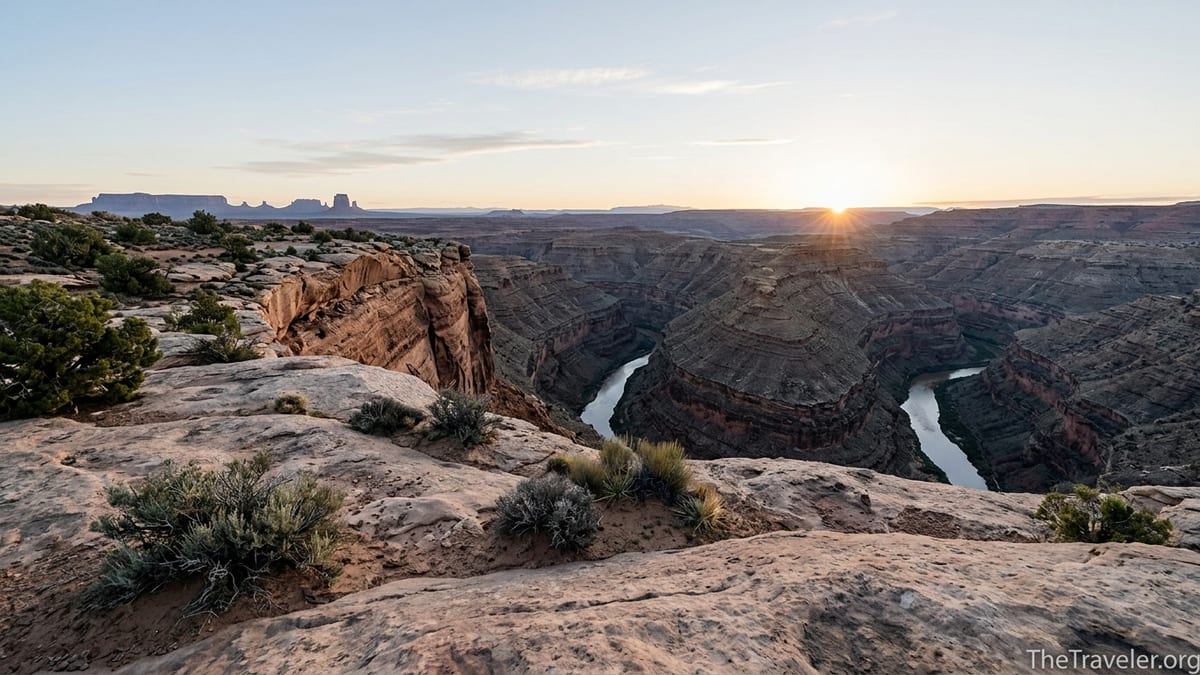
On the southern rim of the mesa, Muley Point offers one of the most expansive viewpoints in the entire Four Corners region. Here you stand at the top of 1,200-foot cliffs and look down on the goosenecks of the San Juan River, with the monoliths of Monument Valley and the buttes of Valley of the Gods layered on the horizon. The five-mile dirt road to the overlook is rough in spots but usually passable in dry weather for careful drivers in a standard car, and the reward at the end is a panorama that feels far from any highway.
Travelers also talk about the small but memorable details: finding a perfectly preserved corncob in a granary tucked high on a ledge, watching ravens ride thermals along the canyon walls, or camping on the mesa top beneath a Milky Way so bright it casts faint shadows. Cedar Mesa trips are less about ticking sights off a list and more about accumulating moments like these.
Permits, Regulations, and How Visiting Actually Works
Because Cedar Mesa is archaeologically rich and relatively fragile, you cannot simply wander anywhere you like without paperwork. Day use permits are required year-round for hikes into most of the major canyons, including Grand Gulch, Slickhorn, and portions of Mule Canyon. These can typically be obtained at self-serve kiosks at trailheads or at the Kane Gulch Ranger Station, where staff can also update you on water availability, recent flash flood damage, and any seasonal closures.
Overnight backpacking requires more planning. Backcountry permits for Grand Gulch and certain tributaries are limited, and during peak seasons in April, May, late September, and October, trips can fill well in advance. A typical backpacker might reserve three nights to hike from Kane Gulch down Grand Gulch to Bullet Canyon, arranging a shuttle between trailheads and carrying several liters of water to bridge dry stretches between springs. It is common to budget around 10 to 15 miles per day depending on route and side trips to ruins.
These regulations are not just bureaucracy. Archaeological sites here have suffered from theft and vandalism over the years. Visitor caps and permit systems are designed to keep canyon use to a level the landscape can absorb while still providing solitude. On a practical level, the ranger station is also where you pick up current information on road conditions. After heavy summer monsoon storms, for example, some dirt access roads can become deeply rutted or impassable for low-clearance vehicles.
There are also strict rules about behavior near cultural sites. You are expected to stay on durable surfaces, never enter structures, avoid touching rock art or moving artifacts, and camp well away from any ruins. Dogs are not allowed in certain canyons, particularly in Grand Gulch, both to protect fragile sites and because steep pour-offs and long dry sections can be dangerous for pets. Knowing and accepting these limitations is part of choosing to visit Cedar Mesa responsibly.
The Experience on the Ground: Roads, Weather, and Services
One of the biggest surprises for first-time visitors is how “off-grid” Cedar Mesa feels even though it lies between paved state highways. Once you leave towns like Blanding or Bluff, there are no grocery stores, motels, or gas stations on the mesa itself. Kane Gulch Ranger Station has helpful staff, maps, and basic information, but no fuel, food, or potable water. A realistic plan means arriving with a full tank, several gallons of water per person in your vehicle, and enough food to be self-sufficient for the duration of your stay.
The main access for the southern mesa is Utah Highway 261, which climbs a dramatic series of dirt switchbacks known as the Moki Dugway. This graded road is carved into the cliff face and gains roughly 1,200 feet in a short distance. Most passenger vehicles can make the drive in dry conditions if you go slowly and downshift, but trailers and large RVs are strongly discouraged. Travelers uncomfortable with heights or exposure sometimes choose to approach from the north via Highway 95 instead, which keeps you on pavement to the mesa top.
Weather adds another layer of complexity. Spring and fall usually offer the best combination of moderate temperatures and reliable road conditions, though cold nights are common, especially in March and November. In summer, daytime highs on the mesa can climb into the 90s Fahrenheit, with canyon bottoms feeling hotter and often airless. Afternoon monsoon thunderstorms from July into September can trigger sudden flash floods in narrow drainages; hikers must watch the sky and avoid slot-like sections when storms are in the forecast. In winter, snow and clay-rich mud can close dirt roads and make even short drives treacherous.
Given these factors, many travelers build Cedar Mesa into a larger Four Corners road trip, using lodging in Bluff, Blanding, or Mexican Hat as a base. A common pattern is to spend a day hiking in Cedar Mesa, then return to a motel for a hot shower and restaurant meal rather than camping every night. Others embrace the remoteness and camp on the mesa at primitive dispersed sites, enjoying dark skies and early starts right from their sleeping bags.
Who Will Love Cedar Mesa (and Who Might Not)
Cedar Mesa tends to appeal most to travelers who enjoy exploration, quiet, and a degree of self-reliance. If your idea of a good vacation is following a well-marked trail to a signed overlook and then grabbing ice cream at a visitor center, this region may feel sparse or even frustrating. Trails here are often minimally marked, navigation relies on reading cairns and wash bottoms, and a “crowded” day on a popular canyon route might mean seeing two or three other groups in eight hours.
History and archaeology enthusiasts often rank Cedar Mesa above more famous parks, precisely because the ruins feel integrated into the landscape rather than isolated behind railings. You might spend an afternoon in Grand Gulch encountering granaries built in tiny alcoves, rock art panels spread along a canyon wall, and a kiva ruin tucked behind cottonwoods, all without any placards or interpretive displays. That sense of discovery, along with the knowledge that Indigenous peoples still hold these places sacred, makes the experience feel more like visiting a living cultural landscape than a museum.
Photographers and landscape lovers also find Cedar Mesa compelling. The sandstone here weathers into rounded domes, pour-offs, and ledges that catch light beautifully at sunrise and sunset. Scenes like House on Fire, the serpentine bends of the San Juan River viewed from Muley Point, or the soft glow of cottonwoods in a canyon bottom in late October offer endless compositions. At the same time, you will not find the dramatic vertical walls of Zion Canyon or the iconic formations of Arches; instead, Cedar Mesa requires you to look more closely at textures, patterns, and subtle shifts in color.
On the other hand, families with very young children, travelers with limited mobility, or those who strongly prefer paved roads and full services might be better served focusing on nearby destinations like Monument Valley, Goosenecks State Park, or Natural Bridges National Monument, where short, developed viewpoints and facilities are more common. Cedar Mesa is not inherently dangerous, but it does assume that visitors are comfortable in a fairly undeveloped desert environment.
Respectful Travel in a Living Cultural Landscape
For many people, one of the most powerful aspects of a Cedar Mesa visit is realizing that you are walking through the homelands of Indigenous communities whose descendants still live in the region. Tribes including the Navajo Nation, Ute Mountain Ute, Hopi, Zuni, and others have strong cultural ties to these canyons and to sites like the nearby Bears Ears buttes that rise above the mesa to the north. The formation of Bears Ears National Monument in 2016 and its later restoration highlighted how important this landscape remains for ceremonial use, traditional knowledge, and identity.
As a result, respectful behavior here goes beyond standard Leave No Trace practices. It means moving quietly around structures, avoiding entering rooms or kivas, and resisting the urge to rearrange pottery sherds or other artifacts into photo-friendly patterns. It also means keeping cultural sites off social media geotags, especially lesser-known ruins that can be easily damaged by increasing traffic. Local organizations and land managers often emphasize that asking “Should I share this location?” is just as important as asking “Can I reach this ruin?”
Some travelers choose to join guided trips with local or regional outfitters, both to deepen their understanding and to reduce the risk of accidental damage. A knowledgeable guide can point out details you might otherwise miss, like subtle petroglyphs nearly obscured by desert varnish or architectural features that hint at how a dwelling was used. They can also model appropriate behavior, from where to step to how far back to stand when viewing fragile structures.
Finally, it is worth remembering that quiet is not just a scenic amenity here; it is part of what locals and tribal members seek to protect. Keeping voices low in canyons, avoiding drones, and choosing camp locations away from obvious ruins all help preserve the sense of place that makes Cedar Mesa distinct. Traveling with humility and awareness is one of the best ways to ensure that the region remains worth visiting for generations to come.
Planning a Realistic Itinerary
To decide if Cedar Mesa fits your plans, it helps to imagine a specific trip. For example, a couple on a weeklong Southwest loop from Salt Lake City might devote three nights to the area. They could base in Bluff, driving 45 to 60 minutes each morning to trailheads. Day one might be an introductory hike to House on Fire and a few other ruins in South Mule Canyon, followed by sunset at Goosenecks State Park. Day two could be a longer outing into Grand Gulch from Kane Gulch, with an early start, packed lunch, and a permit picked up at the ranger station. On day three, they might drive the Moki Dugway up to Cedar Mesa, continue to Muley Point, and bring camp chairs and a picnic dinner to watch the evening light on the San Juan River canyons.
A more adventurous group of friends might choose a three-day backpack in Grand Gulch. After securing permits well in advance, they would stage vehicles at Kane Gulch and Bullet Canyon, then descend from one trailhead, camp two nights in the canyon at designated or previously impacted sites away from ruins, and climb out at the other. Daily mileage might run between 8 and 12 miles, accounting for side trips to notable cliff dwellings. They would carry a water treatment system and plan around known springs, such as those marked on BLM maps and confirmed with rangers shortly before departure.
Even short visits can be worthwhile if expectations are set correctly. A road tripper passing through on Highway 95 between Hanksville and Blanding could stop for a half-day walk in Mule Canyon, spending an hour at House on Fire and then exploring farther up-canyon before returning to the car. Another traveler might simply drive the Moki Dugway, detour to Muley Point for an hour of wide-open views, and continue to Monument Valley. In each case, the key is matching your ambitions to your time, skills, and the conditions on the ground.
Budget-wise, Cedar Mesa can be relatively affordable compared with heavily commercialized national park towns. Lodging in Bluff or Blanding is often moderately priced outside peak holidays, and camping on BLM land is generally low-cost or free in designated areas, though you should expect to bring your own water and pack out all waste. The main expenses tend to be fuel, permits, and any guided trips you might book, rather than entrance fees or resort-style amenities.
The Takeaway
So, is Cedar Mesa worth visiting? For travelers who value solitude, subtle desert beauty, and a chance to engage with ancient cultural landscapes in a careful, low-key way, the answer is a resounding yes. This is not a drive-through park with a greatest-hits loop; it is a place that rewards those willing to walk a little farther, carry a bit more water, and learn before they go.
If you are drawn to the idea of standing alone at Muley Point as the last light fades over the San Juan River, or quietly tracing a canyon bottom until a centuries-old granary appears in an alcove above you, Cedar Mesa may become the most memorable stop on your Southwest itinerary. If, on the other hand, you prefer well-developed viewpoints, abundant services, and clearly signed attractions, you might appreciate the region more as a scenic side trip than a primary destination.
Ultimately, what travelers love most about Cedar Mesa is its sense of integrity. The canyons still feel like places where time moves slowly and where human presence, past and present, is part of a much larger desert story. Visiting with respect, preparation, and a willingness to embrace a little uncertainty is the best way to discover whether this remote Utah plateau is worth it for you.
FAQ
Q1. Do I need a permit to hike in Cedar Mesa?
Yes. Most of the major canyons, including Grand Gulch and sections of Mule and Slickhorn Canyons, require day-use permits, and overnight backpacking requires limited backcountry permits that should be arranged in advance during peak seasons.
Q2. What is the best time of year to visit Cedar Mesa?
Spring (roughly March through May) and fall (late September through October) usually offer the most comfortable temperatures and more reliable road conditions, though you should still be prepared for cold nights and sudden storms.
Q3. Can I visit Cedar Mesa in a regular car?
Yes, you can reach trailheads along Highways 95 and 261 in a standard passenger car in good weather, but many side roads are rough dirt or clay and may require high clearance and dry conditions; always check with rangers about current access.
Q4. Is Cedar Mesa family friendly?
Families with older children who are used to hiking and heat often enjoy Cedar Mesa, especially shorter outings like House on Fire or viewpoints like Muley Point, but very young children may struggle with the exposure, lack of shade, and minimal facilities.
Q5. Are there campgrounds on Cedar Mesa?
There are a few basic, first-come, first-served camp areas and extensive dispersed camping on nearby BLM lands, but facilities are minimal, so you should arrive self-contained with water, a toilet system if required, and a plan to pack out all trash.
Q6. How long should I plan to stay?
If you want to sample a couple of hikes and viewpoints, two to three days is reasonable, while dedicated hikers and backpackers often spend four to six days exploring multiple canyons or combining Cedar Mesa with nearby areas like Natural Bridges and Monument Valley.
Q7. Is it safe to explore ruins on my own?
It is generally safe if you are prepared and careful, but you must never enter structures, climb on walls, or touch rock art, and you should stay back from fragile ledges; if you are unsure about navigation or proper etiquette, consider hiring a guide.
Q8. Will I have cell service on Cedar Mesa?
Coverage is spotty to nonexistent once you leave nearby towns, so you should download maps in advance, let someone know your itinerary, and be prepared to rely on paper maps or GPS devices rather than your phone.
Q9. Can I bring my dog?
Dogs are allowed in some areas on leash, but they are prohibited in certain canyons such as Grand Gulch to protect sensitive cultural sites and fragile environments, so always confirm current rules before bringing a pet.
Q10. How does Cedar Mesa compare to better-known Utah parks?
Cedar Mesa is far less developed and less crowded than parks like Zion or Arches, with fewer marked trails and services but more opportunities for quiet, exploratory hiking and close, respectful encounters with ancient cultural sites.