


Hidden deep in Utah’s Bears Ears region, Junction Ruin is one of Grand Gulch’s most evocative ancestral sites. Reaching it requires more planning than a typical trailhead stroll, but for hikers willing to prepare, the Junction Ruin Trail offers a powerful combination of canyon scenery, archaeology, and solitude. This guide brings together current information on access, maps, regulations, and on-the-ground tips so you can visit Junction Ruin safely and respectfully.
Get the latest updates straight to your inbox!
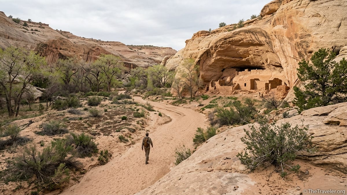
Where Junction Ruin Is and Why It Matters
Junction Ruin sits in Grand Gulch, within the Bears Ears region of southeastern Utah, an area managed primarily by the Bureau of Land Management. The ruin is near the confluence of Kane Gulch and Grand Gulch, which is how it earned its name. Hikers typically reach it from the Kane Gulch Ranger Station on Utah Highway 261, about an hour’s drive southwest of the town of Blanding. This is not a roadside pullout but a backcountry-style outing into a remote canyon system.
The site itself is an Ancestral Puebloan cliff dwelling complex, with masonry rooms tucked under overhanging sandstone, scattered sherds, and other cultural traces that tell the story of people who lived here centuries ago. The broader Grand Gulch area holds one of the densest concentrations of ancestral sites in the Southwest, and Junction Ruin is often described by hikers as a natural “introductory chapter” to this canyon-long open-air museum.
Unlike high-profile destinations such as Mesa Verde or Chaco, there are no paved walkways or rangers standing beside Junction Ruin. That is part of its appeal, but it also means visitors shoulder more responsibility. You will need to navigate a desert canyon trail, interpret basic topo maps, carry your own water, and understand how to move through living archaeological landscapes without causing harm.
From a practical standpoint, Junction Ruin also serves as a waypoint for longer backpacking trips. Many multi-day Grand Gulch itineraries swing past the ruin on their way down-canyon. Even if you only plan a day hike, it helps to understand that you are entering a larger backcountry network where distances, route choices, and weather matter.
Access, Permits, and Seasonal Considerations
Most day hikes to Junction Ruin begin at the Kane Gulch Ranger Station on Utah Highway 261. From Blanding, you follow US 191 south, then head west on UT 95 before turning onto UT 261 toward Cedar Mesa. The ranger station is signed along the highway and acts as both an information hub and the main access point for the upper Grand Gulch drainage. Plan roughly 50 to 60 minutes driving from Blanding, longer if you stop at overlooks or drive more cautiously in bad weather.
Day hiking to Junction Ruin generally requires a self-issue or standard day-use permit for Grand Gulch, available at or near the ranger station for a modest fee per person. Prices can change, but visitors should expect to pay a small amount comparable to other BLM-managed cultural hiking areas. Overnight trips require backcountry permits and often advance reservations during peak seasons such as late March through May and late September through October. Because regulations and fees are updated periodically, check with the Kane Gulch Ranger Station before you travel and again on arrival.
Spring and fall are the favored seasons for this hike. Daytime highs are usually more comfortable, and water sources in the canyon are more reliable. In June through early September, temperatures on the exposed benches can climb well above 90 degrees Fahrenheit, and heat exhaustion becomes a genuine risk. In winter, cold nights, occasional snow on the rim, and ice in shaded sections of the canyon can complicate travel, though strong, experienced hikers do still visit.
Flash flooding is a serious concern in the desert canyon country of Bears Ears. Even if the sky above you is blue, storms upstream can send water surging down tributaries. When you pick your hiking window, look not only at daily highs and lows but at regional radar and recent storm patterns. Many visitors plan Junction Ruin as a shoulder-season trip, aiming for cool but settled weather in April or October and starting early in the day to avoid afternoon instability.
Understanding the Junction Ruin Trail and Distance
The most common way to visit Junction Ruin is via the Kane Gulch Trail, which leaves directly from the ranger station. From the parking area, you cross the highway and follow a signed path down into Kane Gulch itself. Early on, the terrain is relatively gentle, with a combination of sandy tread and bedrock. As you descend, the canyon walls rise around you and the trail alternates between open wash walking and more defined use paths along benches.
Expect a round-trip distance in the region of 8 miles for a dedicated out-and-back day hike to Junction Ruin, which aligns with BLM descriptions that call this an advanced full-day outing rather than a casual stroll. That distance feels longer in practice because of sand, intermittent rock-hopping, and time spent exploring the ruin and its surroundings. Most hikers take 5 to 7 hours door to door, depending on fitness, heat, how often they stop, and whether they combine the hike with side trips to other panels or alcoves.
The trail is not engineered like a national park path, but there is a reasonably clear route on the ground. You will encounter cairns in some stretches and simple wooden signs or posts at key junctions, but you should not rely on those alone. Many hikers carry a printed topo map of Grand Gulch showing the main drainages, plus an offline-capable navigation app that includes the Kane Gulch trail and the approximate location of Junction Ruin. Because mobile reception is often nonexistent once you drop into the gulch, be sure to download any digital maps before leaving Blanding or Monticello.
As you approach the junction with Grand Gulch, the canyon opens and there are more alcoves and side walls to scan. Hikers often talk about the moment when the ruin suddenly comes into view across the drainage, tucked into an alcove above the canyon floor. Even though the structure is prominent once you know where to look, stay mindful of your footing; it is tempting to walk while craning your neck at the sandstone, but loose cobbles and small ledges mean you are better off stopping whenever you want to search the cliffs for masonry.
Navigation, Maps, and On-the-Ground Wayfinding
Because this hike unfolds in a complex canyon system, having multiple layers of navigation support makes the experience smoother and safer. At a minimum, visitors should carry a printed map of the Grand Gulch or Bears Ears area that shows Kane Gulch and its junction with Grand Gulch. These maps are often sold in outdoor shops in Moab, Blanding, and Monticello, and some ranger stations stock them as well. Many hikers use maps that include shaded relief and contour lines, which make it easier to visualize where side canyons join the main drainage.
In addition to paper maps, offline GPS apps have become standard tools for desert hikers. Popular services offer downloadable map tiles that show topography, satellite imagery, and user-recorded tracks to Junction Ruin. For example, many visitors pre-download a track of the Kane Gulch trail and a waypoint for Junction Ruin while they still have cell service in town. Once in the canyon, their phone acts essentially like a modern map and compass, recording their progress and helping them stay oriented at major bends or where the main path splits around obstacles.
Despite this, Grand Gulch is not a place to follow a dotted line blindly. Wash bottoms often braid or shift after heavy storms, and boot tracks can lead to side alcoves that dead-end at pour-offs. A practical strategy is to use your GPS or map to confirm big-picture decisions, such as whether you are still headed generally down-canyon toward the confluence, while also reading the landscape in front of you. When the main wash becomes boulder-choked, for instance, you may find a well-trodden path on a bench slightly above the streambed; if you find yourself climbing steep dirt slopes or navigating exposed ledges, you have probably left the established route.
One useful real-world example: hikers occasionally report overshooting Junction Ruin because they become absorbed in the canyon and fail to check their position. If you have a waypoint marked, glance at it when you think you are nearing the confluence. If the map indicates you are a quarter mile downstream of the junction and you still have not seen the ruin, stop, scan the cliffs, and be willing to backtrack slightly rather than charging ahead hoping it will appear around the next bend.
What to Expect at Junction Ruin
When you finally reach Junction Ruin, you will find a complex of masonry structures tucked under a broad sandstone alcove. Some parts of the ruin rest at or near canyon-floor level, while others are perched on ledges that require more careful access or should not be approached at all. The visual impression is striking: square doorways, stacked stone walls, and plaster remnants stand out against the sculpted rock, all framed by cottonwoods and willows along the canyon bottom.
Visitors often describe needing a few minutes simply to absorb the setting. The ruin sits where two canyons meet, so you are aware of water, shade, and travel corridors coming together in a place where people once gathered, stored food, and looked after families. It is common to spot pottery sherds, stone flakes, and other artifacts on the ground in the broader area, though these items must be left exactly where they lie. Even casual rearrangement or pocketing a “souvenir” accelerates the loss of context that archaeologists rely on to understand how this place functioned.
You should expect no fences, boardwalks, or interpretive displays at the ruin itself. Any signage you encounter will likely have been posted further up-canyon or at the ranger station, emphasizing general Bears Ears visitation ethics rather than describing Junction Ruin in detail. This low-key presentation is intentional; it helps maintain the sense of discovery while reducing visual intrusion in a fragile environment. The trade-off is that you must arrive with your own background knowledge or be content to simply sit quietly and imagine life here centuries ago.
Photographers will find numerous vantage points, but the best images usually come from a respectful distance using a longer lens rather than walking directly under fragile rooms. A responsible approach might be to sit in the shade at the edge of the clearing, frame the ruin against the canyon walls, and capture the way light moves across the stone in late morning or midafternoon. Shooting from further back also keeps you from unintentionally creating social trails or loosening stones below the structures.
Safety, Water, and Desert Travel Realities
The Junction Ruin Trail is not technical, but the combination of distance, exposure, and remoteness demands real preparation. Start by carrying more water than you think you need. Many hikers bring at least 3 liters per person for the day, more in hot conditions. While natural water sources may exist in the canyon in spring or after storms, they are not guaranteed, and any water you do find must be carefully treated with a filter, chemical drops, or UV device before drinking.
Sun exposure is a major factor on the hike out. The climb from the shaded canyon floor back up toward the ranger station often feels significantly hotter than the descent, especially in the early afternoon when the sun is high. Light-colored, breathable clothing, a wide-brim hat, and a high-SPF sunscreen used generously on face, neck, and hands can make the difference between an enjoyable day and a punishing slog. Many hikers prefer to depart the ranger station shortly after it opens in the morning, aiming to reach Junction Ruin before midday and to be well on their way back up-canyon before the worst of the heat.
Footwear should be sturdy but does not need to be specialized. Low-cut hiking shoes with good tread work well for most people, though some prefer mid-height boots for extra ankle support in the rocky wash sections. Trekking poles are optional but can help with balance on loose sand and during short, steeper steps in and out of the wash. Plan for the possibility of minor scrapes and blisters by carrying a compact first-aid kit and simple blister care items such as tape or padded dressings.
Finally, remember that help is far away. Once you are in the canyon, you are unlikely to see large crowds, especially in shoulder seasons or on weekdays. Consider carrying a satellite communicator if you have one, let someone in town know your exact plan, and build enough margin into your schedule to handle a slower pace or an unexpected rest without racing darkness back to the trailhead.
Respectful Visiting: Leave No Trace & Cultural Sensitivity
Junction Ruin is not simply an outdoor museum; it is part of a living cultural landscape that many Tribal members still regard as sacred. That reality should shape every decision you make on the hike, from where you walk to how you talk about the place afterward. A basic starting point is to treat the entire canyon as if it were a combination of home and cemetery rather than a playground. If you would be uncomfortable with someone leaning on a gravestone or eating lunch on a historic church altar, you should feel likewise about climbing into rooms or sitting on ancient walls.
The practical guidelines are straightforward but powerful. Stay on durable surfaces such as existing paths, slickrock, or dry sand rather than trampling cryptobiotic soil or delicate vegetation. When you approach archaeological sites, keep a respectful distance, do not enter rooms or step on walls, and never touch rock art. Pottery sherds, stone tools, and any other artifacts must be left exactly where you find them. Avoid eating or leaving packs directly under fragile overhangs where crumbs and micro-trash can attract animals and accelerate erosion.
Noise and group size also matter. Grand Gulch’s appeal lies partly in its quiet, and loud voices can carry surprisingly far in the canyon. Consider speaking softly and limiting music from speakers so that other visitors, as well as wildlife, can experience the place in relative peace. Groups should be kept to a size that can move gently along the trail; if you are hiking with a larger party, it might make sense to spread out your start times slightly so you are not overwhelming any single alcove or narrow section of trail at once.
Waste management is another critical aspect of Leave No Trace. Pack out all trash, including food wrappers, orange peels, and tissues. Human waste should be handled according to Grand Gulch regulations, which typically prohibit burial near water sources or in alcoves and may encourage or require the use of pack-out bags in popular areas. Before your trip, review the most up-to-date Bears Ears guidance on human waste so you arrive with the right equipment and expectations.
Planning a Broader Bears Ears Hiking Day Around Junction Ruin
Many travelers fold the Junction Ruin hike into a longer Bears Ears road trip. For example, a visitor staying in Blanding or Bluff might spend one full day hiking to Junction Ruin and another exploring more accessible roadside sites such as the Butler Wash Ruins overlook or the petroglyph panels near the San Juan River. This mix allows you to balance a demanding backcountry outing with shorter, family-friendly walks that still offer deep cultural immersion.
Accommodation options range from simple motels in Blanding, with early breakfasts that allow a dawn departure to the trailhead, to small inns and vacation rentals in Bluff with easy access to restaurants for a post-hike meal. Some travelers choose to camp on nearby public lands instead, positioning themselves closer to the highway junctions that lead to both Kane Gulch and other trailheads. Regardless of where you stay, aim to fuel up in town before driving out, as there are no services at the ranger station beyond water access and information during staffed hours.
Because the Junction Ruin hike often leaves people both inspired and tired, it can be wise to plan a low-key late afternoon. After returning to the highway and driving back toward town, many visitors stop at road-side viewpoints over Comb Ridge or Cedar Mesa, watching the light shift across the sandstone without committing to another serious hike. This pattern of one major canyon outing followed by gentler sightseeing not only fits most fitness levels but also gives you space to reflect on what you have seen.
If you are traveling with children or less-experienced hikers, consider setting a generous turnaround time before you leave the ranger station. For instance, you might decide that regardless of how close you believe you are to Junction Ruin, you will turn back after a certain time of day to ensure you return to the trailhead with daylight to spare. Treat reaching the ruin as a bonus rather than the only definition of success; the canyon itself, with its alcoves, birdlife, and shifting rock colors, is well worth the journey even if you choose not to push all the way to the confluence.
The Takeaway
The Junction Ruin Trail is a classic Bears Ears experience: beautiful, remote, and layered with cultural meaning. It demands more of visitors than a typical viewpoint hike, but that extra effort is exactly what preserves its sense of discovery. With accurate maps in hand, a clear understanding of the route from the Kane Gulch Ranger Station, and a realistic plan for water, heat, and time, most reasonably fit hikers can visit Junction Ruin as a full-day outing.
What transforms this from a simple hike into a memorable journey is the way you choose to be present. Moving quietly through the canyon, noticing the plants and rock textures, pausing before the ruin to imagine daily life here, and leaving no trace of your visit helps ensure that Junction Ruin remains a place of learning and connection rather than just another stop on a crowded checklist. In a landscape where every alcove might shelter a story, that mindset is as essential as any piece of gear in your pack.
FAQ
Q1. How long is the hike to Junction Ruin and how difficult is it?
The out-and-back hike to Junction Ruin from the Kane Gulch Ranger Station is roughly 8 miles round trip. Most visitors describe it as a moderately strenuous full-day hike because of sandy sections, some uneven footing, and the climb back out of the canyon, especially in warm weather.
Q2. Do I need a permit to hike to Junction Ruin?
Yes, day hikers typically need a day-use permit for Grand Gulch, obtained at or near the Kane Gulch Ranger Station. Overnight trips require backcountry permits and may need advance reservations in peak seasons, so it is wise to confirm current requirements with land managers before your visit.
Q3. What is the best time of year to hike the Junction Ruin Trail?
Spring and fall are generally the best seasons, with cooler temperatures and more reliable water in the canyon. Many hikers aim for April, May, late September, or October. Summer heat can be intense, and winter trips require comfort with cold, occasional snow or ice, and shorter daylight hours.
Q4. Is the trail to Junction Ruin well marked?
The Kane Gulch trail has a discernible route on the ground, with some cairns and simple signs, but it is not marked like a national park walkway. Wash bottoms may braid or change after storms, so hikers should carry a paper map and an offline GPS map and be prepared to use basic navigation skills rather than relying solely on trail markers.
Q5. Can I get close to or enter the rooms at Junction Ruin?
Visitors should not enter rooms, climb on walls, or touch any part of the structures. The most responsible way to experience Junction Ruin is from a respectful distance, viewing and photographing it from stable ground without disturbing masonry, artifacts, or surrounding soils.
Q6. Is there water available on the Junction Ruin Trail?
Water availability in Kane Gulch and Grand Gulch varies with season and recent weather. You should not rely on finding drinkable water and should carry enough for your entire hike. Any natural water encountered must be treated before use, and checking recent conditions with the ranger station is important if you are counting on refilling.
Q7. What gear should I bring for a day hike to Junction Ruin?
Plan to carry plenty of water, high-energy snacks, sun protection, a printed map, an offline-capable navigation app or GPS, a basic first-aid kit, and sturdy hiking footwear. Many people also bring trekking poles, a brimmed hat, and light layers to handle large temperature swings between the cool canyon floor and the warmer rim.
Q8. Are children or less-experienced hikers suitable for this trail?
Fit, motivated older children and teens with prior hiking experience can often handle the Junction Ruin Trail, especially in cooler months and with an early start. For younger or less-experienced hikers, it can be more appropriate to walk only partway down Kane Gulch and set a conservative turnaround time rather than committing to the full distance.
Q9. Is camping allowed near Junction Ruin?
Overnight camping in Grand Gulch is regulated and typically requires a backcountry permit, with specific rules about where you can camp and minimum distances from ruins, rock art, and water sources. Most day hikers do not camp near Junction Ruin itself, and regulations are designed to keep campsites away from sensitive cultural sites, so always follow current guidelines from the managing agency.
Q10. How can I visit Junction Ruin respectfully?
Visiting respectfully means staying on existing paths, keeping a safe distance from walls and rock art, never removing or rearranging artifacts, keeping noise low, and packing out all trash and waste. It also involves recognizing that this is a living cultural landscape valued by descendant communities and choosing to move through it with humility, care, and an attitude of learning.