


Hidden deep in Utah’s Grand Gulch, Junction Ruin is one of the most evocative and well preserved archaeological sites on Cedar Mesa. Visiting it is not as simple as pulling off the highway and walking a few minutes. Reaching this Ancestral Puebloan settlement requires planning, navigating remote desert roads, securing permits, and hiking several miles into a wilderness canyon. For travelers willing to do the work, though, Junction Ruin offers a powerful experience of time, landscape, and living Indigenous history.
Get the latest updates straight to your inbox!
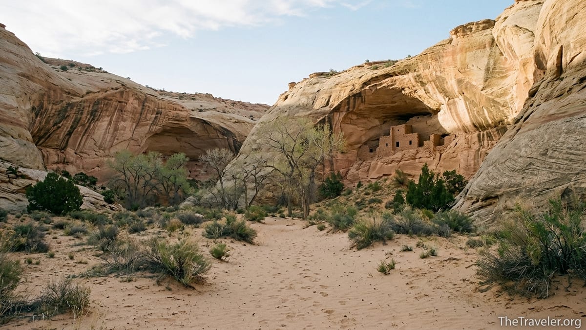
Understanding Junction Ruin and the Grand Gulch Setting
Junction Ruin sits at the confluence of Kane Gulch and Grand Gulch on Cedar Mesa in southeastern Utah, within the Bears Ears region. This is an area renowned for its high concentration of Ancestral Puebloan sites, including cliff dwellings, kivas, granaries, and rock art panels. Archaeologists date most of the masonry structures in Grand Gulch to the late Pueblo II and Pueblo III periods, roughly from the 1000s to the late 1200s. When you stand below the alcoves at Junction Ruin, you are looking at the remains of multi story dwellings, storage rooms, and ceremonial spaces that were occupied centuries before Europeans arrived in North America.
The site is considered one of the best preserved in Grand Gulch. Stone walls still stand shoulder high in places, doorways remain clearly defined, and plastered surfaces and original timber elements are visible if you look carefully. Pottery sherds and corn cobs are often present in the sand and talus slopes, which is one reason strict rules protect the area. The setting itself, in a wide slickrock canyon framed by cottonwoods and sandstone walls streaked with mineral stains, feels surprisingly intimate despite the scale of the landscape.
Grand Gulch is managed by the Bureau of Land Management as part of a larger system of National Conservation Lands. Visitor numbers have increased in recent years, especially in spring and fall, but Junction Ruin still feels remote. You are hours from the nearest town, out of cell range for most of the route, and entirely responsible for your own safety. That combination of archaeological richness and genuine wilderness is what draws careful, prepared travelers here.
Permits, Regulations, and When to Go
Because Grand Gulch holds a dense concentration of cultural sites, the BLM manages access through a fee and permit system. Day use permits are required for hikes into Grand Gulch and can typically be obtained at self service kiosks at major trailheads or at Kane Gulch Ranger Station. If you plan to backpack and camp in the canyon, you need an overnight permit, which is more limited and usually picked up in person at the ranger station during its seasonal operating hours. As of early 2026 the station is generally staffed from March 1 to June 15 and from September 1 to October 31, roughly 8 a.m. to noon from Thursday through Sunday, but travelers should verify current hours and any quota changes before they arrive.
Fees are modest compared with many national parks and help fund trail maintenance, site monitoring, and educational programs. For a typical visiting party, the day use fee for Cedar Mesa and Grand Gulch is on the order of a few dollars per person per day. Overnight permits cost more but remain affordable for multi day trips when split among a small group. If you are building a broader Southwest itinerary that includes parks like Arches or Canyonlands, keep in mind that Grand Gulch permits are separate from national park passes.
Spring and fall are by far the best times to hike to Junction Ruin. From March through May and again from late September through October, daytime highs often sit in the 60s to 70s Fahrenheit, with cold but manageable nights. Water seeps and potholes in Grand Gulch are more likely to hold reliable water in these shoulder seasons, though conditions vary widely from year to year. Summer brings dangerous heat, frequently exceeding 90 or 100 degrees in the canyon with little shade at midday, while winter can layer snow and ice on steep slickrock approaches and make access roads muddy or impassable.
Because permits are capped, it is wise to build flexibility into your schedule. For example, a traveler basing out of Blanding might plan three nights in the area, aiming for Junction Ruin one day, House on Fire in Mule Canyon another day, and a scenic drive to Natural Bridges National Monument or Valley of the Gods as a backup option if weather or permits conflict with a Grand Gulch hike.
Getting to the Trailhead: Driving Cedar Mesa’s Back Roads
Reaching the standard Junction Ruin access point involves driving remote highways and at least some graded dirt roads. Most visitors approach from either Blanding or Bluff. From Blanding, you generally take Utah Highway 95 west across open high desert for about 30 miles, then turn south on Utah Highway 261, which climbs onto Cedar Mesa and provides signed access to Kane Gulch Ranger Station. From Bluff, you can head west on Highway 163 and then north on Highway 261, climbing the dramatic Moki Dugway gravel switchbacks to the mesa top. Although passenger cars routinely manage this route in dry conditions, it is steep and exposed, so nervous drivers sometimes prefer the gentler approach from Blanding.
Kane Gulch Ranger Station sits just off Highway 261 and serves as the main information hub and permit office for Grand Gulch. There is a paved parking area, vault toilets, and, when open, limited drinking water inside. Many travelers stop here first to speak with rangers about current road and trail conditions. For instance, a ranger might tell you that a recent storm left mud on one of the side roads or that a particular seep near Junction Ruin is running weakly, which could change your water strategy for the day.
The specific access road used for Junction Ruin can vary depending on your chosen route and current management recommendations. The most common approaches involve either hiking from a trailhead off Utah 261 and following a marked route towards the Kane Gulch and Grand Gulch junction, or arranging a longer through hike that uses two trailheads, such as entering via Kane Gulch and exiting at another access like Bullet Canyon or Collins Canyon. In recent trip planner brochures, the BLM identifies a Junction Ruin day hike route roughly 4 miles one way into Grand Gulch, though actual distance depends on your exact start point and side explorations.
In practical terms, a typical visitor in a high clearance vehicle like a Subaru Outback or Toyota RAV4 will find the main Cedar Mesa access roads passable in dry weather. However, heavy rain or snow can quickly turn normally manageable dirt segments into deep mud or rutted tracks. Because grading and conditions change year to year, it is smart to check with the ranger station or local outfitters in Blanding or Bluff before committing to any spur road. Carry a paper topographic map or a large scale map such as the National Geographic Trails Illustrated Grand Gulch sheet alongside your GPS.
Hiking Route Overview: From Rim to Junction Ruin
Most hikers treat Junction Ruin as a full day outing, allowing between four and six hours depending on pace, side trips, and conditions. A common loop or out and back route is around 7.5 to 8 miles, with roughly 1,000 feet of cumulative elevation change. The hike begins on the mesa top in open pinyon juniper woodland, crosses sandy or cryptobiotic soil flats, and then drops into the sculpted sandstone of Kane Gulch before continuing down to the junction with Grand Gulch where the ruin complex stands.
The initial descent from the rim tends to be the steepest section, sometimes involving short rock steps, dirt slopes, and narrow benches where trekking poles can be useful. Once in the canyon bottom, the trail often follows a mix of packed sand, bedrock, and occasional shallow water crossings if springs are flowing. In a typical dry spring, hikers might encounter ankle deep pools that can be bypassed on rock ledges, but in wetter periods standing water and mud can slow progress. Expect to walk through vegetation such as willows and cottonwoods that grow along the intermittent stream channel.
As you approach the confluence, the canyon widens and side alcoves appear more frequently. Junction Ruin occupies several of these alcoves on both sides of the canyon. Most parties reach the lower site first, where clusters of rooms and kivas sit tucked high under a sandstone overhang. The main route up from the canyon floor usually follows a well worn but still steep social trail up talus slopes and bedrock shelves. While you do not need technical climbing gear, the final approach involves loose rock, exposure to drop offs, and narrow ledges where a calm head for heights is important.
Because the exact lines of travel to and around the ruin can change with erosion and management efforts, hikers should look for subtle rock cairns, faint tread, and any posted signs. Rangers sometimes adjust recommended access paths to reduce trampling or protect fragile structures. A GPS track from a reputable recent source can help, but should never override on the ground conditions and any new guidance you receive from land managers.
On Site: Exploring Junction Ruin Respectfully
When you finally stand beneath the alcoves of Junction Ruin, the complexity of the site becomes clear. You may see masonry walls built in tight alignment with the curving back of the alcove, small storage rooms tucked into natural cavities, and circular depressions that mark former kivas. Carefully examine the stonework and you will notice how masons interlocked sandstone blocks and chinked gaps with smaller stones and mortar. In some rooms, plaster still clings to interior walls. Lintels above doorways may show the ends of original wooden beams, now charred or weathered.
Despite its relative remoteness, Junction Ruin is vulnerable to the touch of every visitor. Following a basic code of conduct is essential. Stay on established paths and rock whenever possible to avoid trampling fragile soils and vegetation. Do not enter kivas or enclosed rooms, even if low walls seem easy to step over. Resist the temptation to sit or lean on walls, which can destabilize centuries old masonry. Leave all artifacts where you find them, including pottery fragments, stone tools, and corncobs. Even picking up a sherd to look at it and putting it back in a slightly different place slowly erodes the archaeological record.
Photography is welcomed, but it is worth thinking about how you frame and share images. For example, some visitors now choose to omit precise location details in public posts, instead describing their trip more generally as a hike in Grand Gulch or Cedar Mesa. This approach recognizes that social media can rapidly amplify visitation to specific sites without corresponding increases in education or management resources. If you are traveling with children or friends who are new to archaeological sites, take a few minutes at the ruin to explain why rules matter: not as arbitrary restrictions, but as ways to ensure future visitors, including Tribal members with ancestral connections, can experience the place intact.
Allow plenty of quiet time just to sit below the alcove and listen. In the middle of the day, light reflecting off pale canyon walls floods the rooms with a warm glow, while in late afternoon the site can fall into cool shade that emphasizes the texture of stone and plaster. Swallows, canyon wrens, and lizards are frequent company. This is still living Indigenous landscape, used today for hunting, plant gathering, ceremony, and reflection. Treat the space as you would a church or cemetery, not as an outdoor museum exhibit.
Safety, Water, and Practical Logistics
Hiking to Junction Ruin is a backcountry undertaking with minimal infrastructure. There are no maintained facilities beyond the trailhead parking area and occasional rock cairns and signs. Mobile phone coverage is spotty to nonexistent once you leave the highway. Before you go, leave a detailed itinerary with someone you trust, including your starting trailhead, planned route, expected return time, and the license plate and description of your vehicle. Visitors who underestimate the remoteness of Grand Gulch sometimes find themselves hiking out by headlamp or spending an unplanned night out.
Water is often available in Grand Gulch near Junction Ruin, but reliability changes seasonally. Some years, a series of clear pools and seep fed trickles exist just downstream of the confluence, while in drier periods these can shrink to stagnant puddles or dry up altogether. As a rule of thumb, carry at least 3 liters of water per person for a shoulder season day hike and more in hot weather, even if you plan to filter from canyon sources. Lightweight pump filters or gravity bags from well known brands like Sawyer or Katadyn work well on the often silty water if you pre settle it in a collapsible bucket or wide mouth bottle.
The route involves uneven footing, some exposure to heights, and potential for sudden weather changes. Afternoon thunderstorms are common in late summer and early fall, bringing lightning and localized flash flooding. If dark clouds build, avoid lingering in narrow side slots or low spots in the main wash, and watch high ledges for falling rock dislodged by wind and rain. Footwear with good traction on sandstone, such as approach style hiking shoes or trail runners, is more useful than heavy, stiff mountaineering boots. Many experienced Cedar Mesa hikers use lightweight shoes paired with trekking poles for added stability on talus and steep dirt.
Because Junction Ruin is not signed or patrolled the way a national park roadside ruin might be, navigation gear is more than a formality. A paper map packaged in a zip bag, a compass, and a fully charged GPS or smartphone with offline maps should all be considered standard kit. For example, you might download USGS topographic tiles for the Kane Gulch and Grand Gulch area in a navigation app and mark waypoints at the trailhead, the canyon entrance, the junction, and your vehicle. Do not rely entirely on electronic devices, which can fail in the cold, run out of battery, or break if dropped.
Pairing Junction Ruin with Other Cedar Mesa Highlights
Most travelers do not drive all the way to Cedar Mesa solely for a single day hike, so it makes sense to build a small itinerary around Junction Ruin. An obvious pairing is Kane Gulch itself. A fit party might backpack from the Kane Gulch trailhead down to Junction Ruin, spend a night or two exploring nearby side canyons and additional sites, and then exit via the same trail or a different canyon such as Bullet or Collins, arranging a shuttle vehicle in advance. Along the way, they could visit other major sites like Turkey Pen Ruin or Stimper Arch, depending on current recommendations and personal fitness.
For day hikers based in Blanding or Bluff, a practical three day plan might look like this: on day one, drive to Cedar Mesa and hike to a shorter but iconic site such as House on Fire in Mule Canyon, which is reached via a relatively easy trail and offers excellent photography opportunities in the right reflected light. On day two, commit to the Junction Ruin hike, starting at dawn to avoid mid day heat. On day three, explore Natural Bridges National Monument’s loop drive and short hikes to its massive sandstone bridges, or drop into Valley of the Gods for a scenic high clearance dirt road drive among free standing rock towers.
Travelers with more time can include a visit to Edge of the Cedars State Park Museum in Blanding either before or after hiking Junction Ruin. The museum houses excavated artifacts, interpretive exhibits, and a restored kiva that help put what you see in Grand Gulch into context. Spending an hour or two there can make your time at Junction Ruin feel richer and more grounded, especially if you are new to Ancestral Puebloan history or traveling with children who learn best through hands on displays.
If you prefer not to hike alone or want expert guidance on route finding and cultural sensitivity, several regional outfitters based in Utah and neighboring states offer guided day hikes and backpacking trips into Grand Gulch and Cedar Mesa. These trips cost more than going independently but can simplify logistics like shuttle arrangements, permit acquisition, and emergency planning. When choosing a guide service, look for companies that emphasize Leave No Trace practices and relationships with Tribal communities connected to Bears Ears.
The Takeaway
Junction Ruin is not a quick roadside stop. It demands a long drive across high desert mesa, a careful eye on weather and road conditions, a clear understanding of permit rules, and a moderately strenuous hike down into and back out of a remote canyon. For those willing to make that effort, the reward is an immersive encounter with one of Utah’s best preserved archaeological sites in a landscape that still feels wild and largely unmechanized.
Standing beneath the alcove, you can trace hand built masonry, imagine the sounds of daily life in the canyon, and sense the deep continuity between the people who built these rooms and the descendant Indigenous communities who remain connected to Bears Ears today. The experience is most meaningful when approached with humility: you are a guest in a living cultural landscape, not a collector of destinations. Bring what you need, take only photos and memories, and leave the site no different than you found it.
If you build Junction Ruin into a broader Cedar Mesa journey that includes places like House on Fire, Natural Bridges, and Edge of the Cedars Museum, you will leave with more than a checklist of scenic views. You will have a tangible sense of how people have lived with this landscape for thousands of years, and how careful travel today can help protect that inheritance for those who come after you.
FAQ
Q1. Do I need a permit to hike to Junction Ruin?
Yes. Day use permits are required for hikes into Grand Gulch, including Junction Ruin, and overnight trips require a separate backpacking permit. You typically obtain these from self issue stations at trailheads or in person at Kane Gulch Ranger Station when it is open.
Q2. Can I visit Junction Ruin as a beginner hiker?
It is possible for a fit, prepared beginner to reach Junction Ruin, but the route is longer and more committing than many front country hikes. Expect 7 to 8 miles round trip, steep sections on the descent and ascent, and uneven footing. If you are new to desert hiking, start with shorter Cedar Mesa trails first or consider joining a guided trip.
Q3. What kind of vehicle do I need for the trailhead access?
In dry conditions, many travelers reach Grand Gulch access points in standard passenger cars using paved highways and well graded dirt roads. However, a high clearance vehicle such as a small SUV offers more margin on rougher segments and after storms. Always check current road conditions with rangers or local businesses before setting out.
Q4. How long does the hike to Junction Ruin take?
Most parties spend between four and six hours hiking to Junction Ruin and back, not including additional time spent exploring the site or resting in the canyon. Starting early in the day gives you cooler temperatures for the climb out and a comfortable buffer in case the route takes longer than expected.
Q5. Is water available near Junction Ruin?
Water is often present in pools and seeps in Grand Gulch near the junction, especially in spring, but reliability varies widely with recent weather. You should always carry enough water for the entire hike and treat any water you collect with a filter or purification method, as natural sources can contain sediment and microorganisms.
Q6. When is the best time of year to go?
Spring and fall offer the most comfortable conditions, with moderate daytime temperatures and generally more reliable water. Summer heat can be intense and hazardous, while winter brings cold, potential ice on slickrock, and occasional access issues on snow covered or muddy roads.
Q7. Can I camp near Junction Ruin?
Overnight camping in Grand Gulch is allowed only with the appropriate backpacking permit and must follow specific regulations on campsite locations, group size, and distance from archaeological sites. You cannot camp directly at Junction Ruin or in alcoves with structures. Rangers at Kane Gulch Ranger Station can explain current rules and suggest appropriate camping zones.
Q8. Are dogs allowed on the trail to Junction Ruin?
Regulations can change, but in many parts of Cedar Mesa and Grand Gulch, dogs are either prohibited on certain trails or strongly discouraged because they can damage fragile soils and disturb wildlife and cultural sites. Before bringing a pet, confirm current rules with the BLM and consider whether the hot, exposed conditions are safe for your animal.
Q9. How do I minimize my impact on the ruins?
Stay on existing paths and bare rock, never climb on walls or enter kivas, and do not touch rock art or masonry. Leave artifacts where they lie, keep food and packs away from structures, and take breaks on durable surfaces. Respectful behavior helps preserve the site for future visitors and for Tribal communities with ancestral ties to the area.
Q10. Is Junction Ruin suitable for children?
Older children and teens with hiking experience and an interest in history can have a meaningful visit, but the route’s length, heat, and exposure require careful judgment. Families should bring ample water and sun protection, take frequent breaks, and set clear boundaries about not climbing on ruins or running near drop offs. For younger children, shorter hikes to nearby sites like House on Fire may be more appropriate.