


The stone villages and cliff dwellings of the Ancestral Puebloan people are scattered across one of North America’s most spectacular landscapes. From the great houses of Chaco Canyon to the cliff palaces of Mesa Verde and the quiet canyons of Bears Ears, travelers can explore a remarkable network of archaeological sites. This guide brings together practical information on maps, driving routes, permits and visitor logistics to help you plan a thoughtful journey through Ancestral Puebloan homelands today.
Get the latest updates straight to your inbox!
Understanding the Ancestral Puebloan Landscape
"Ancestral Puebloan" refers to the Native peoples who farmed, traded and built multiroom stone dwellings across what is now the Four Corners region of Colorado, Utah, New Mexico and Arizona. Their communities flourished roughly from 600 to 1300, developing complex irrigation systems, kivas and great houses tied together by road networks across the high desert and canyon country. Today, their descendants include modern Pueblo communities along the Rio Grande and in Arizona and New Mexico, and many public lands remain deeply significant living cultural landscapes rather than frozen "ruins."
For visitors, this means you are traveling through active Indigenous homelands as much as you are visiting archaeological parks. Many major Ancestral Puebloan sites are protected as national parks and monuments, such as Mesa Verde National Park in southwest Colorado and Chaco Culture National Historical Park in northwest New Mexico, along with Aztec Ruins, Bandelier, Hovenweep, Canyons of the Ancients and Canyon de Chelly. These parks concentrate hundreds or thousands of documented sites, but the wider region is also dotted with smaller pueblos, field houses, rock art panels and granaries that you may encounter along backroads or hiking trails.
Because of the scale of this landscape, maps are essential. Highway atlases for Colorado, Utah, New Mexico and Arizona show the primary access routes. On the ground, detailed road maps from state tourism offices and printed atlases like the DeLorme state Gazetteers help you navigate the maze of numbered county and Bureau of Land Management roads that lead to trailheads and overlooks. For hiking and site exploration, topographic maps or GPS apps that cache offline data are strongly recommended, since much of the backcountry has no cell signal.
While many iconic sites have paved access and clear signage, others sit at the end of long, washboarded dirt roads. Trip planning should factor in seasonal monsoon rains, snow and mud. It is wise to talk with park rangers or local visitor centers before you rely on a small road shortcut that looks easy on a map. Their on-the-ground advice often makes the difference between a smooth day of exploring and an unplanned night stuck on a clay track after a thunderstorm.
Core Hubs: Mesa Verde, Chaco Canyon and Aztec Ruins
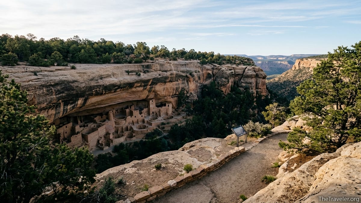
Mesa Verde National Park in Colorado is often the first stop for travelers curious about Ancestral Puebloan history. The park preserves thousands of archaeological sites, including several hundred cliff dwellings tucked into sandstone alcoves. Most visitors base themselves in nearby Cortez or Durango, where standard mid-range motels often range from around 120 to 200 US dollars per night in high season, and day-trip into the park. The main park road is paved but steep and winding, so allow at least 45 minutes to drive from the entrance to the primary cliff dwelling overlooks.
Mesa Verde’s visitor center, near the highway entrance, is a key mapping resource. Rangers provide current maps showing which cliff dwellings are open on self-guided walks, which require ranger-led tours, and which roads or trails may be closed due to rockfall, fire or winter conditions. Tour tickets for famous sites such as Cliff Palace and Balcony House typically must be reserved ahead in the main season, often online, and the schedule and fees can change year to year. Once in the park, wayfinding is straightforward, with signed parking areas and well-marked loops, but it is common for summer travelers to underestimate both driving times and the amount of water needed for even short hikes at elevation.
Chaco Culture National Historical Park in northwest New Mexico requires more logistical planning. The park sits at the end of miles of graded dirt road that can become difficult or impassable when wet. Most travelers approach from US highways via state and county roads, and the last stretches may be washboarded. A printed map or GPS track is very helpful here, because intersections can be confusing and signage limited. Visitors often camp in the park campground or stay in motels in towns like Farmington, Bloomfield or Gallup and day-trip into the canyon.
At Chaco, the visitor center is your first map stop. Staff provide a loop drive map pinpointing great houses such as Pueblo Bonito, Chetro Ketl and Casa Rinconada, along with trailhead maps for backcountry routes that climb to mesa-top overlooks. Because the park emphasizes resource protection, visitors are expected to stay on marked trails and avoid climbing on walls or entering fragile rooms. There is limited shade, no food service and often limited fuel nearby, so full gas tanks, plenty of water and sun protection are essential parts of your navigation plan, not afterthoughts.
North of Chaco, Aztec Ruins National Monument outside the town of Aztec, New Mexico, offers a more compact yet striking introduction to ancestral architecture. Here, a stabilized great house and reconstructed kiva sit within walking distance of the visitor center and parking lot. Modest entry fees or federal passes apply, but there are no complicated road approaches. This makes Aztec Ruins an appealing half-day stop for travelers driving between Chaco, Mesa Verde and points further north, and its small museum provides helpful context if you are early in your exploration of the culture.
Utah’s Backcountry Sites: Bears Ears, Cedar Mesa and Hovenweep
In southeast Utah, a constellation of Ancestral Puebloan sites lies within Bears Ears National Monument, Cedar Mesa and Hovenweep National Monument. This area feels wilder and less structured than the big national parks. It rewards careful map work and rewards travelers who are patient with gravel roads and who are comfortable managing their own time, water and navigation.
Cedar Mesa and Comb Ridge, now part of Bears Ears National Monument, are managed primarily by the Bureau of Land Management. Day hiking in popular canyons such as Grand Gulch and Mule Canyon typically requires a day hiking pass, while overnight trips use a limited-permit system that may involve advance reservations and pickup at ranger stations such as Kane Gulch. Fees and limits are adjusted periodically to protect fragile archaeological sites and vegetation from heavy visitation, so it is important to check permit details and current maps directly with managers shortly before your trip rather than relying on older guidebooks.
Cartographically, this is one of the most intricate parts of the Ancestral Puebloan world. Unpaved roads branch off Utah state highways toward trailheads like Mule Canyon Interpretive Site, where short walks lead to a cluster of stabilized structures and kivas. Detailed maps from state tourism offices, DeLorme or similar atlas publishers, and digital navigation apps that show land management boundaries are extremely helpful. Many canyon trailheads are signed only with small BLM markers or may be obscured by snow or dust. It is wise to mark GPS waypoints at your vehicle and trail junctions so you can retrace your path if afternoon monsoon storms obscure landmarks.
Hovenweep National Monument, straddling the Colorado and Utah border, consolidates multiple clusters of tower-like ruins along small canyons. The main Square Tower Group is accessed via paved and good graded roads suitable for standard rental cars in dry conditions. A park map from the visitor center shows the loop trail around the canyon rim and driving directions to outlier units, which may require higher-clearance vehicles. Many travelers base themselves in Cortez, Blanding or Bluff, then make a day loop combining Hovenweep with nearby Canyons of the Ancients sites, such as Lowry Pueblo and the Canyons of the Ancients Visitor Center and Museum.
The Trail of the Ancients: A Road Trip Framework
The Trail of the Ancients National Scenic Byway provides a useful mental map and driving framework for travelers who want to link multiple Ancestral Puebloan sites by car. Portions of this route cross Colorado, Utah and New Mexico, tying together landmarks such as Mesa Verde, Canyons of the Ancients, Hovenweep, Four Corners, Bears Ears, Chaco Canyon and Aztec Ruins. State transportation departments and local tourism offices publish free print maps that outline the byway, including distances between towns and major junctions.
On the Colorado segment, for example, the byway loops from Cortez toward Dolores and the McPhee Reservoir, passes the Canyons of the Ancients Visitor Center and Museum, and branches to key sites like Lowry Pueblo. A spur heads toward Mesa Verde’s entrance. This arrangement means you can base in Cortez for several days, visiting Mesa Verde one day, Canyons of the Ancients the next, and Hovenweep on a third, without constantly changing lodging. Wayfinding on this segment is relatively straightforward, with state highways and well-marked county roads used by regular traffic and farm vehicles.
In New Mexico, the Trail of the Ancients route links places such as Chaco Culture National Historical Park, Casamero Pueblo near Prewitt, and Aztec Ruins, along with striking landforms like Shiprock and the Bisti Badlands. Here, a mix of paved state highways and county roads carry you between hubs like Gallup, Farmington and Bloomfield. Because some sections pass through Navajo Nation or other tribal lands, it is important to respect local regulations, avoid wandering onto unmarked side roads, and only visit archaeological sites that are clearly open to the public. Tribal tourism offices and local visitor centers often provide supplemental maps that highlight viewpoints and explain any photography restrictions.
Utah’s share of the Trail of the Ancients reaches into Bears Ears country, Monument Valley and Natural Bridges National Monument. This portion combines scenic desert highway stretches, such as the steep switchbacks of the Moki Dugway, with occasional dirt road sections. Fuel, food and lodging can be far apart. When planning your route on paper or digital maps, pay attention to services marked in small towns like Bluff, Blanding and Mexican Hat, and consider booking key lodging ahead during spring and fall, when visitation peaks.
Planning Around Seasons, Access and Permits
Seasonal conditions strongly shape what you can realistically do in a given trip. Summer brings hot days, afternoon thunderstorms and busy trails, particularly at well-known parks like Mesa Verde and Bandelier National Monument near Los Alamos. Winter quiets crowds but can close higher-elevation roads and trails due to snow and ice. Spring and fall often offer the most comfortable temperatures, but also see increased visitation and more competition for campground and tour reservations.
Permits are a recurring theme in the Ancestral Puebloan landscape. Some parks, such as Mesa Verde, control access to the most fragile cliff dwellings through ranger-led tours that require advance booking and charge modest additional fees on top of park entry. Backcountry-heavy areas like Cedar Mesa or certain canyons in Bears Ears use day and overnight permit systems to limit numbers on specific trails. Canyon de Chelly on Navajo Nation lands often requires that visitors be accompanied by authorized local guides for travel off the main rim drives. For each of these, the exact rules and fees can change as managers respond to erosion, graffiti or simply heavier use, so always verify details directly with the relevant park or agency as you finalize your plan.
Access conditions are likewise fluid. Dirt approach roads to Chaco Canyon, Hovenweep outliers or Cedar Mesa trailheads that feel straightforward in dry weather can become treacherous in a single storm. In practical terms, that means building buffer days into your itinerary rather than scheduling long chain drives that rely on everything going perfectly. Many experienced visitors plan a rough loop first, then on arrival check road reports at visitor centers, adjust which sites they visit on which days, and keep a list of backup options, such as museums or short roadside hikes, in case conditions change quickly.
For navigation, combining old and new tools works best. Paper maps from state transportation departments and park brochures provide a big-picture overview, showing where services cluster and how far it is between fuel stops. Smartphone apps and GPS devices add precision, especially for unmarked turnoffs or network of primitive roads, but only if you download maps for offline use before driving into areas without coverage. Topographic map layers are particularly useful around canyons and mesas, helping you visualize the steepness and orientation of your hikes.
Respectful Visiting: Etiquette and Site Protection
Although many Ancestral Puebloan sites look like abandoned stone structures, for descendant communities they are often still active places of memory and ceremony. Visiting respectfully is as important as finding the right road on the map. That starts with staying on marked trails and obeying closure signs, which are usually based on both safety and cultural sensitivity. It continues with refraining from touching rock art, leaning on walls, or entering rooms that are not clearly opened as viewing spaces by park staff.
Photography is usually allowed at major parks and monuments, but even there it is wise to avoid close-up images of human remains, burial areas or ongoing ceremonies. On tribal lands such as Navajo Nation or Zuni Pueblo, more specific photography rules may apply, sometimes requiring permits or banning images of certain structures altogether. Visitor centers and tribal tourism offices routinely brief guests on these expectations, and it is good practice to ask if you are ever uncertain.
Artifact removal is a persistent problem across the region. Even small pottery fragments, stone tools or corncobs are protected cultural resources. Leaving them where you find them preserves context for future research and for the communities that still visit these places to honor their ancestors. Park rangers frequently note that for every traveler who pockets a sherd as a souvenir, dozens of others lose the chance to see it in its original setting. A simple personal rule to adopt is to admire, photograph and then leave everything in place.
Finally, the broader Leave No Trace principles apply with special weight in the desert. Cryptobiotic soil crusts, which often look like dark, knobby patches on the ground, are living communities that help hold sand in place and retain moisture. A single footprint can destroy them and increase erosion around fragile masonry or petroglyph panels. Sticking to durable surfaces like established trails, rock and dry washes not only protects these biological communities but also keeps your own route-finding simpler and clearer.
Sample Itineraries and Practical Logistics
Many travelers approach the Ancestral Puebloan world from regional airports such as Albuquerque, Durango, Grand Junction or Salt Lake City. Rental cars range widely in price depending on season, but a typical midsize vehicle often runs in the range of 50 to 90 US dollars per day before insurance. A standard car is sufficient for visiting major parks and most national monuments in normal dry conditions. If your itinerary leans heavily toward remote trailheads or you are traveling in the shoulder seasons when mud and snow are more likely, a higher-clearance vehicle or all-wheel drive becomes more attractive, and some rental agencies in Albuquerque and Salt Lake City explicitly market such vehicles for Southwest road trips.
A classic one-week loop might start in Albuquerque, with a night in town to gather supplies and review maps, then head to Chaco Canyon for a full day and one night of camping or a motel stay in a nearby town. From there, you could drive north to Aztec Ruins and on to Cortez as a base. Spend two days exploring Mesa Verde, one day combining Canyons of the Ancients and Hovenweep, and a final day driving south or east via Durango or back toward Albuquerque. This route keeps most driving days under four hours while visiting several major hubs.
A different route might focus on Utah’s Bears Ears and Cedar Mesa region. You could base in Blanding, Bluff or Monticello, towns with a mix of budget motels, small inns and campgrounds, and then spend several days doing day hikes from paved highway turnouts into canyons like Butler Wash or Mule Canyon. Add a side trip to Natural Bridges National Monument and, if road conditions allow, to remote overlooks with views into Cedar Mesa’s deep tributary canyons. Here, logistics center on securing the right day or overnight permits and staying flexible in case summer thunderstorms or spring snow change road and trail access.
Budget planning should incorporate entry fees and passes. Many Ancestral Puebloan sites are on federal lands that accept the America the Beautiful annual pass, which can quickly pay for itself if you visit several parks and monuments in a single trip. Others, such as certain tribal parks or areas managed by the Bureau of Land Management, may charge separate fees or require permits sold at specific ranger stations. Checking a site’s current fee structure a month or two before your visit gives you time to adjust your route or set aside cash for places that do not accept cards.
FAQ
Q1. What is the best starting point for an Ancestral Puebloan road trip?
Albuquerque and Durango are popular starting points because they have commercial airports, rental cars and easy highway access to Chaco Canyon, Aztec Ruins and Mesa Verde. From either city you can design loops that add Utah or further New Mexico sites as time allows.
Q2. Do I need a four wheel drive vehicle to visit these sites?
You do not need four wheel drive for most major parks such as Mesa Verde, Bandelier, Aztec Ruins or the main area of Hovenweep in dry conditions. A higher clearance vehicle or all wheel drive is helpful, and sometimes necessary, for backcountry trailheads in Cedar Mesa, certain approaches to Chaco Canyon after storms, or for exploring unpaved county roads where mud and ruts are common.
Q3. How many days should I plan for Mesa Verde National Park?
Plan at least one full day to see the main overlooks and take a ranger guided cliff dwelling tour, and two days if you want to hike more trails and explore quieter loops. Travel time from nearby towns and the winding park road often surprise first time visitors, so extra time makes the visit more relaxed.
Q4. Is it possible to visit Chaco Canyon on a day trip?
Yes, many travelers visit Chaco on a long day trip from towns like Farmington, Bloomfield or Gallup, but the unpaved approach roads and the amount of hiking and exploration available mean an overnight nearby or at the park campground often creates a more satisfying experience. Always check current road conditions before committing to the drive.
Q5. Are there guided tours that focus on Ancestral Puebloan sites?
Yes, a number of regional outfitters and local guides offer multi day tours that include Mesa Verde, Chaco Canyon, Aztec Ruins, Bears Ears and tribal parks such as Canyon de Chelly or Ute Mountain Tribal Park. These tours can be useful for travelers uncomfortable with remote driving or who want deeper cultural interpretation from Native guides.
Q6. Can I camp near Ancestral Puebloan sites?
Many areas have campgrounds, such as the campground within Mesa Verde, the campground at Chaco Canyon and various public and private campgrounds near towns like Cortez, Bluff and Blanding. Dispersed camping is allowed on some Bureau of Land Management lands but is restricted or prohibited near sensitive archaeological areas, so always follow local regulations and use established sites when possible.
Q7. What maps should I bring if I use my phone for navigation?
It is wise to bring at least a printed state highway map or park brochures along with downloading offline maps in your navigation apps before entering remote areas. A detailed road atlas for each state you plan to visit and topographic map layers on your phone or GPS provide valuable backup when cell service disappears or batteries run low.
Q8. How can I make sure I am visiting respectfully?
Stay on marked trails, do not touch rock art or climb on walls, leave all artifacts where you find them, and follow photography and access rules explained by rangers and tribal guides. Quiet behavior, modest clothing and a willingness to treat these places as living cultural landscapes rather than theme parks all contribute to a respectful visit.
Q9. Are children welcome at Ancestral Puebloan sites?
Yes, children are welcome and many sites have short trails and junior ranger style activities. Parents should be prepared for heat, sun and elevation, keep children close near cliff edges and fragile walls, and use visits as chances to talk about history, respect and conservation.
Q10. What is the takeaway for planning an Ancestral Puebloan trip?
The key is to think in terms of regions rather than single sites, combine solid maps with flexible daily plans, and approach each place with patience and respect. Doing so turns a simple road trip into a deeper journey through both the visible stone architecture and the living cultures that continue to care for these lands today.