
More news on this day
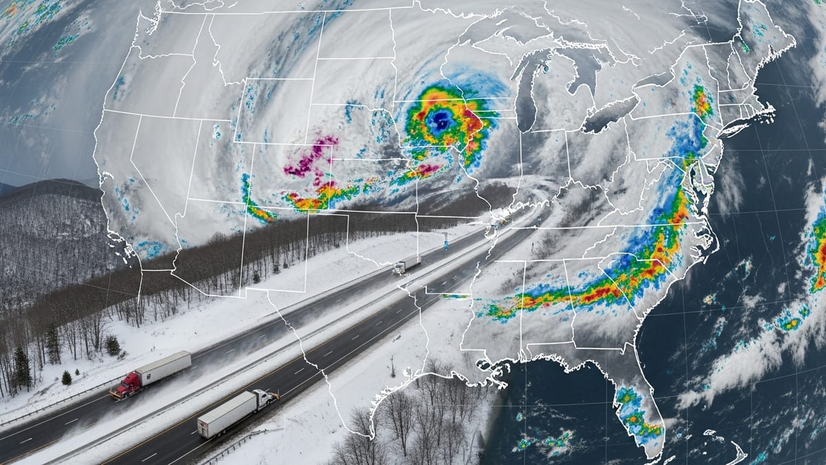
As the 2026 FIFA World Cup opens in Mexico City on June 11, a sprawling and dangerous storm system is battering Chicago and a swath of the Midwest with tornado threats, destructive winds and torrential rain, unleashing travel disruption across key Great Lakes and Midwest hubs just as thousands of football fans are on the move.
Get the latest news straight to your inbox!
Storm Corridor Stretches From Chicago to Lake Michigan Cities
Forecast discussions and real-time radar imagery on Thursday indicate a volatile atmosphere from eastern Iowa across northern and central Illinois into southern Wisconsin, western Michigan and northern Indiana. Chicago sits near the heart of this zone, with nearby urban centers such as Milwaukee, Madison, Rockford, Peoria, Grand Rapids, Kalamazoo and South Bend all facing the risk of severe thunderstorms capable of producing multiple tornadoes, intense straight-line winds and rapid flooding.
The current outbreak follows an already punishing day of storms on Wednesday, when a fast-moving line of thunderstorms with hurricane-force gusts swept through parts of Wisconsin, Illinois and Michigan. Early reports describe trees snapped or uprooted, structures damaged and power lines knocked down across the region, leaving hundreds of thousands without electricity in scattered communities as Thursday’s second wave of weather approaches.
Publicly available outlooks from national forecasters highlight a corridor of elevated tornado potential embedded within a broader severe threat. Analysts point to a combination of warm, humid air at the surface and strong west-southwesterly winds aloft, a setup that can support rotating supercell thunderstorms and fast-moving squall lines capable of producing both tornadoes and destructive straight-line winds.
Parts of Illinois, including the Chicago metro area, as well as portions of Wisconsin, Indiana, Iowa, Missouri and Minnesota are also under a heightened risk for excessive rainfall. Urban neighborhoods, highway underpasses and low-lying communities around these cities are particularly vulnerable to flash flooding if repeated storms track over the same areas.
Travel Chaos Hits Air, Road and Rail Networks
The timing of the severe weather is especially disruptive for travel, arriving on a weekday when regional business traffic is already heavy and international travel is ramping up in connection with the World Cup. Airlines serving Chicago’s O’Hare and Midway airports, as well as Milwaukee, Grand Rapids and other regional terminals, are bracing for significant delays and potential ground stops when storms move directly overhead.
Thunderstorms capable of producing cloud-to-ground lightning, strong crosswinds and low visibility typically cause cascading delays as aircraft are held at the gate, rerouted around storm cells or forced into holding patterns. Flight-tracking dashboards on Thursday already show rolling schedule adjustments, and travelers are being encouraged to monitor airline updates closely and allow extra time for check-in and security lines that can lengthen quickly when multiple departures are disrupted.
On the ground, major interstate corridors that knit together these Midwestern cities are at risk of rapid slowdowns or closures as storms pass. Sections of Interstates 90 and 94 between Chicago, Rockford, Madison and Milwaukee, as well as I-55 toward Peoria and I-94 and I-196 through western Michigan toward Grand Rapids and Kalamazoo, are likely to see hazardous conditions, including ponding water, fallen branches and localized debris. State transportation agencies are warning that even brief cloudbursts could overwhelm drainage in busy urban stretches, triggering sudden lane closures and lengthy backups.
Passenger rail and intercity bus services that link Chicago with Milwaukee, Madison and other regional hubs may also be affected, with the potential for delays caused by downed trees, power interruptions and weather-related speed restrictions. Travelers across the region are being urged to build flexibility into their plans and to be prepared for rapidly changing conditions well into Thursday night.
World Cup Excitement Meets Weather-Related Anxiety
The dangerous storms arrive on the same day that the 2026 FIFA World Cup officially kicks off, with Mexico hosting the opening match in Mexico City. The tournament runs from June 11 to July 19 across Canada, Mexico and the United States, with matches scheduled in multiple American cities over the coming weeks. Chicago is not a host venue, but it serves as a critical aviation and rail gateway for fans traveling to and from several World Cup locations across the continent.
Many supporters with itineraries routed through Chicago, Milwaukee or nearby airports are facing a tense opening day, watching forecasts as closely as match previews. Tickets and accommodations have often been booked months in advance, leaving little room to rearrange schedules at short notice. Some fan groups are sharing informal guidance on social platforms, advising others to arrive early at departure points, keep mobile boarding passes and identification ready and pack essential items and medications in carry-on luggage in case of sudden overnight disruptions.
In Mexico City, where the first World Cup ceremony and match are taking place, local outlooks point to a chance of thunderstorms in the vicinity of the capital, raising parallel concerns about lightning, heavy rain and traffic snarls near stadium and fan-zone areas. While the most intense severe-weather focus on Thursday remains over the central United States, the broader pattern underscores how weather-sensitive major sporting events can be, especially when linked to complex global travel networks.
The convergence of a record-breaking tournament, peak summer travel demand and a high-impact storm system means that disruptions in one region can reverberate widely. Missed connections, diverted flights and shifted schedules in the Midwest can quickly spill over into Canadian and Mexican gateways, affecting fans, tournament staff and regular travelers alike.
Communities Reel From Damage as New Rounds of Storms Loom
For communities across the Midwest, the current severe-weather episode is not an isolated incident but part of an extended stretch of turbulent conditions this week. Reports from Wednesday’s storms detail widespread wind damage, from rural areas of southern Wisconsin and northern Illinois to more densely populated stretches closer to Chicago and Milwaukee. Fallen trees and torn roofing have damaged homes and businesses, while snapped power poles have left utility crews working through the night to restore service.
Preliminary tallies from weather and power-outage monitoring services indicate that hundreds of thousands of customers lost electricity at some point during the midweek storms, with additional outages expected as Thursday’s storms track through. Road closures for debris removal and downed lines have complicated local commutes, emergency responses and the movement of essential goods, adding to the strain on residents already coping with earlier damage.
Emergency managers and local broadcasters across Illinois, Wisconsin, Michigan and Indiana are using live coverage, social media updates and push alerts to emphasize the dangers of rapidly intensifying storms that can produce tornadoes or destructive wind gusts with limited lead time. Residents in and around Chicago, Milwaukee, Madison, Rockford, Peoria, Grand Rapids, Kalamazoo and South Bend are being urged to keep phones charged, identify sturdy shelter locations in advance and remain prepared for sudden warnings throughout the afternoon and evening.
In several affected areas, cleanup from the first wave of storms is proceeding side by side with fresh preparations for new cells, creating a sense of fatigue and anxiety. Streets lined with broken branches and temporary blue tarps on rooftops stand in stark contrast to the festive banners, flags and watch-party signs going up for the World Cup, illustrating how quickly celebration can be overshadowed by the realities of extreme weather.
Heightened Flood and Tornado Risk Through Thursday Night
Meteorologists tracking the system warn that the severe threat will persist into Thursday night as individual thunderstorms congeal into larger complexes that can race eastward across the Great Lakes and into the Ohio Valley. These evolving structures often bring the highest risk of widespread damaging winds, embedded tornadoes and extended periods of heavy rain, especially along and just south of the main storm track.
Flooding concerns are elevated by saturated ground in parts of the central United States, where repeated rounds of storms over recent days have already dropped significant rainfall totals. With additional downpours possible, urban flooding, overflowing creeks and rapidly rising small rivers are all on the table, particularly near the metro regions that have expanded across former floodplains and wetlands.
Publicly available guidance encourages travelers and residents to avoid driving through water-covered roads, to watch for quickly changing conditions on navigation apps and roadside message boards and to be ready for detours at short notice. For long-distance drivers heading toward or away from World Cup-related destinations, planning alternate routes and checking conditions along the entire path of travel are key steps to reduce the risk of being stranded between cities.
Across the affected region, the day is unfolding as a stark reminder of how vulnerable modern transportation networks are to intense weather systems. As the world’s attention turns to the opening matches of the planet’s biggest sporting event, millions of people in the Midwest are balancing excitement for football with practical concerns about safety, mobility and recovery from yet another round of severe storms.