


Naguabo does not work like a big resort town with a checklist of paid attractions. It is a wet, green corner of eastern Puerto Rico where the Caribbean coast, the Río Blanco watershed and the southern slopes of the Luquillo Mountains all press into one compact municipality. Planning 1, 2 or 3 days here is less about filling every hour and more about matching coast, forest, food and weather in a way that feels relaxed rather than rushed. This guide offers a flexible framework, grounded in Naguabo’s real geography and access, so you can build days that flow naturally instead of chasing rigid schedules.
Get the latest updates straight to your inbox!
Understand Naguabo’s Geography Before You Plan
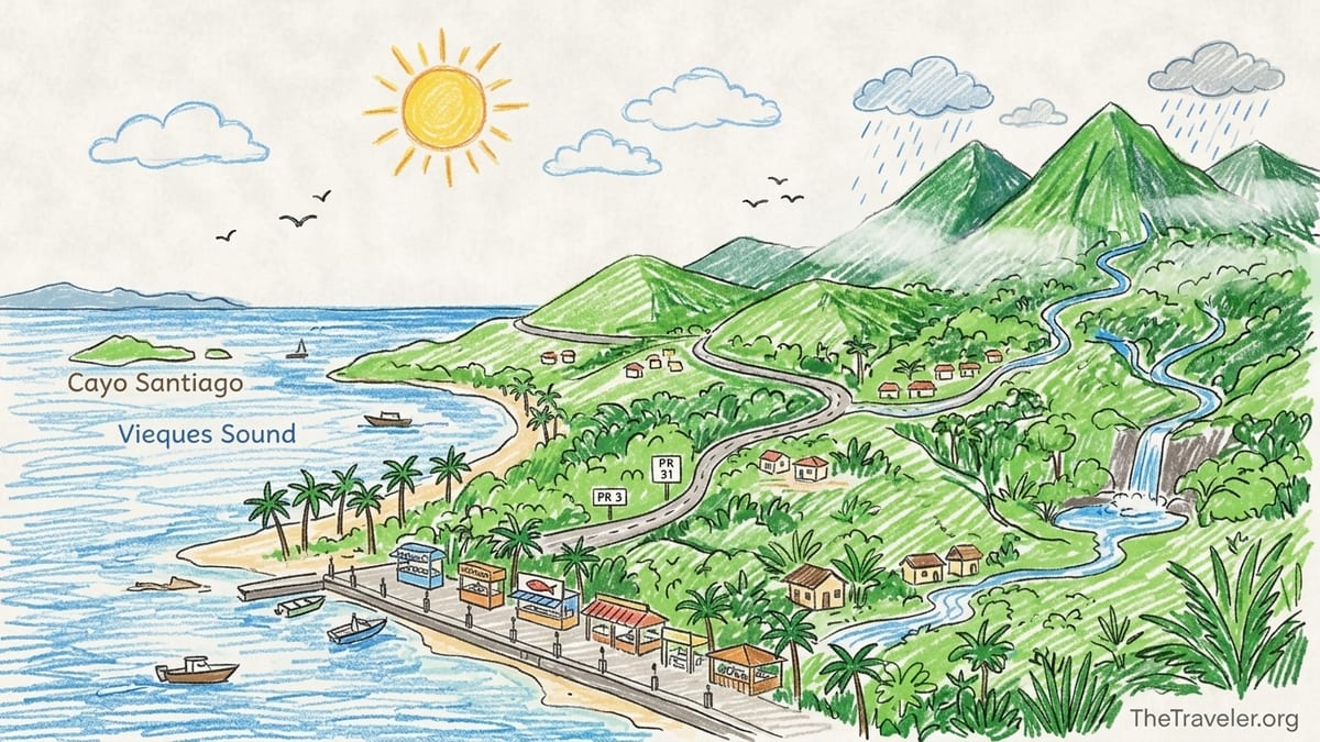
Good Naguabo itineraries start with a map in mind. The municipality stretches from the Caribbean Sea up to the higher elevations of the Sierra de Luquillo. The coastal hub for visitors is the Malecón de la Playa Húcares, Naguabo’s waterfront promenade lined with seafood kiosks and small restaurants facing Vieques Sound and Cayo Santiago across the water. Inland, roads such as PR 3 and PR 31 climb into rural barrios like Río Blanco and Peña Pobre, then into the Río Blanco watershed that drains the southern slopes of the Luquillo Mountains toward the sea.
According to Puerto Rico water resource studies based on Department of Natural and Environmental Resources data, the Río Blanco watershed covers about 27.7 square miles on the south side of the Sierra de Luquillo, including tributaries such as the Sabana, Icacos, Cubuy and Prieto rivers. These streams start high in what is now managed as part of El Yunque National Forest and descend through forest and pasture before flattening out near the coastal plain at Naguabo. That geography explains both the town’s nickname, “El Pueblo de los Enchumbaos,” for its frequent rain, and the number of accessible river spots and roadside cascades in the hills above town.
For itinerary planning, think of three distinct zones. The first is the coast and fishing village area around Playa Húcares and nearby beaches like Playa Tropical and Naguabo Beach, where you find most dining and evening activity. The second is the mid‑elevation rural interior around villages and farms, where you can drive along the Río Blanco valley and find small swimming holes and viewpoints. The third is the higher elevation forest along PR 191 South, which provides a lesser used but atmospheric gateway to the rain‑soaked slopes of El Yunque, with several recreation areas mapped by the U.S. Forest Service.
Travel times between these zones are short in distance but longer than they look because of curves, rain and narrow lanes. From the Malecón to the start of the mountain climb toward Río Blanco, for example, you might drive only 20 to 30 minutes, but that can stretch if heavy showers pass over the watershed and visibility drops. Building in buffers between zones keeps the day from feeling like a race up and down the mountain.
How Weather and Access Shape Any Naguabo Itinerary
Naguabo’s proximity to El Yunque means heavy rainfall is common, especially in the afternoons and at higher elevations. Locals will tell you that a morning that begins bright and hot on the Malecón can turn into mist or downpours along the Río Blanco corridor by mid‑day. For trip planning this means that any river swimming, rainforest walking or waterfall photography is best scheduled for earlier in the day, with extra time padded in case of downpours, temporarily muddy tracks or brief road delays from fallen branches or small slides.
The southern access road to El Yunque, PR 191 South, climbs into the forest from Naguabo and has historically been under‑used compared to the northern gateway near Río Grande. Forest Service planning documents describe PR 191, PR 988, PR 9966 and PR 186 as the main access routes into El Yunque, but also point out that road conditions and low public awareness mean the southern segment sees far fewer visitors. In practice this can be an advantage for travelers who want quieter scenery, but it is essential to check current information with the El Yunque National Forest office or recreation map updates, especially regarding any gates, partial closures or restricted segments around old landslide areas.
Because the Río Blanco watershed drains steep slopes, rivers can rise and fall quickly after rainfall. Local drivers know to look for marks on rocks and bridge pilings that show high water from previous floods, and to turn around instead of trying to cross flooded low spots. As a visitor, you should build weather buffers directly into your plan. For example, if you intend to spend a morning exploring a riverside recreation area off PR 191 South, avoid booking a fixed, nonrefundable lunch reservation with a precise time back on the Malecón. Aim instead for flexible eating options so that if a rain cell passes and you wait it out for forty minutes in a shelter, the rest of the day can simply slide back without stress.
Another practical factor is driving at night on rural roads. Curvy mountain segments between the coast and villages like Río Blanco see minimal street lighting, and fog is common when clouds sit low over the slopes. For itinerary design, this argues for ending any high‑elevation or river activities in time to be back on the coast before dark, then keeping evenings centered near the Malecón, where parking, lighting and restaurant choices are all concentrated.
One Day in Naguabo: Pair the Waterfront With River or Rainforest
With only one day in Naguabo, the aim is to combine the coastal atmosphere of Playa Húcares with a taste of the rivers and forest that feed it, without turning the visit into a frantic loop. The simplest framework is coast in the early morning for orientation, then a late morning and early afternoon inland for river or rainforest, and finally a relaxed late afternoon and evening back on the waterfront for food and sunset views.
Start at the Malecón de Naguabo, officially the Malecón de la Playa Húcares. This seafront promenade runs along a compact bay with views toward the offshore keys and the silhouettes of Vieques on the horizon. It is one of Puerto Rico’s better known waterfront strips, with dozens of kiosks and restaurants specializing in fried seafood, pastelillos de chapín and cold drinks. Visitors commonly choose spots like El Makito, Pelikanos or El Navegante for a late breakfast or early lunch, with many plates in the 15 to 30 dollar range depending on whether you order whole fried fish, mofongo stuffed with seafood, or simpler fritters and sides.
By late morning, drive inland toward the Río Blanco corridor or toward PR 191 South for a short forest experience. A realistic one‑day option is to follow PR 31 then the signed turnoffs that parallel the river, stopping at small pullouts where locals picnic and cool off in natural pools when water levels are safe. If Forest Service updates indicate that recreation sites along PR 191 South are open, you can continue uphill until you reach one of the marked picnic or river access points identified on the southern El Yunque recreation map. This gives you the sensory feel of cloud forest, rushing streams and cooler temperatures without the need to complete a long formal hike.
Leave yourself at least an hour to drive back down comfortably to the coast, with another half hour of buffer for slow traffic or weather. Back at the Malecón in the late afternoon, you can choose a seafood dinner at a different restaurant than where you started, watch local families strolling the promenade, and see the fishing boats returning. Many travelers cap the day with a slow walk along Playa Tropical south of the Malecón or a brief detour to Naguabo Beach, then return to their base elsewhere on the east coast or settle into a local guesthouse.
Two Days: Split Coast and Food From River and Mountain
With two days, you can separate the coastal food and village atmosphere from the higher and wetter interior. This reduces weather stress, because if one day brings heavy rain over the Río Blanco watershed you can pivot that day toward the coast and push river activities to the clearer window. The guiding principle is one day weighted to the Malecón, nearby beaches and food culture, and one day built around river valleys and the southern slopes of El Yunque.
On the coast and food day, keep driving to a minimum. Arrive mid‑morning, check into a local inn or rental if you are staying overnight, and claim a slow lunch right on the waterfront. Food lovers may plan a casual tasting tour of several known spots in the area. For example, you might begin with pastelillos and fried fish at one of the traditional kiosks, then seek out a sit‑down seafood platter at a restaurant like Pelikanos, and finish with drinks at a beach bar such as Salpicón or a newer spot listed in local gastronomy campaigns. Because the Malecón and Playa Húcares area is compact, you can park once and move on foot between multiple venues during the afternoon and early evening.
The river and mountain day can then be planned with an early start. Depart the coast after an early coffee and simple breakfast, then drive up PR 31 and onto the Río Blanco roads before mid‑morning clouds build. Your main goal is not to reach a single signature waterfall but to experience the layered environments within the watershed: lowland sections where the river braids through pasture and farm plots, mid‑elevation bends where the valley tightens and you start passing simple hanging bridges or older aqueduct structures, and finally the misty upper reaches near El Yunque where you may hear coquí frogs even in late morning.
Depending on current Forest Service guidance, you may be able to access designated recreation sites along PR 191 South. These often provide basic picnic tables, river access points and sometimes small shelters or restrooms. Travelers who prefer guided experiences can pre‑book a local operator that offers “rainforest and river” excursions from the east‑coast resort cluster around Fajardo or Humacao and request a route that approaches El Yunque via Naguabo rather than the busier northern entrance. In both self‑guided and guided cases, keep a strict personal rule that if heavy rain is already falling upriver or thunder is forecast, you treat river access and swimming as optional and not essential to the success of the day.
In the afternoon of your river day, aim to be descending toward the coastal plain by 15:00 or 16:00. This leaves room to shower and change before another relaxed dinner on the Malecón or at one of the inland country restaurants highlighted by municipal tourism campaigns. Two days with this split also allow you to adjust last minute. Should the first morning dawn with low clouds and misting rain on the mountain, simply flip your plan: keep that day on the waterfront with food and short drives, and save the river and forest for whichever day promises steadier weather.
Three Days: Deeper El Yunque South, Guided Activities and Nearby East Coast
A three day stay invites you to move beyond first impressions without pretending that Naguabo alone offers endless conventional attractions. Instead, the extra time lets you deepen your connection with the Río Blanco watershed and the southern flank of El Yunque, add a guided outdoor activity, and include slower food stops or side trips elsewhere on Puerto Rico’s east coast. The rhythm becomes one day mostly coast, one day mostly river and mountain, and one day that flexes between Naguabo’s hills and neighboring municipalities such as Ceiba, Yabucoa or Humacao.
On your forest‑focused day, use current El Yunque South recreation maps to choose one or two specific sites along PR 191 South that match your comfort level. Some travelers may prefer locations where you can park near the road and walk a short distance to a river pool to sit on rocks and listen to the water. Others may opt for longer but still moderate walks along old road traces that climb into cooler zones with cloud forest vegetation. Even without formal trailheads, these routes require attention to footing, changing conditions and exit timing. Bring proper shoes with grip, a lightweight rain jacket, and ideally a printed or downloaded high‑resolution map of the southern district in addition to any mobile navigation.
The extra day also makes a guided outdoor activity realistic without rushing. While Naguabo itself is more about informal rivers than organized attractions, outfitters based in nearby east‑coast towns advertise experiences that can be paired with a Naguabo base. Examples include small‑group rainforest hikes that finish with a meal on the Malecón, canyoning or waterfall rappelling excursions in less crowded stretches of the Luquillo Mountains, or kayaking trips in bioluminescent bays nearer Fajardo followed by a late seafood supper in Playa Húcares. If you book such experiences, confirm pickup locations and end times so you can still drive the rural sections of PR 3 or PR 31 in daylight.
The third day can also serve as a buffer and expansion day for the wider east coast. If strong rain lingers over Naguabo’s watershed, you might drive south or west along PR 3 to explore beaches around Yabucoa or the resort community of Palmas del Mar in Humacao, then return to Naguabo in the evening. If conditions are fine, you could instead revisit a favorite riverside spot at a quieter time of day, or spend an unhurried afternoon sampling pastries at a local bakery, fruit stands along PR 31 and one more long, drawn‑out seafood meal on the waterfront. Three days is enough time to have at least one portion of the trip feel entirely unscheduled, which often becomes the most memorable part.
Throughout a longer stay, keep a close eye on updated information for road conditions on PR 191 South and any advisories from the El Yunque National Forest regarding access, especially after strong storms. As of mid‑2020s planning documents, the central section of PR 191 that once fully crossed the mountains remains broken by an old landslide and is not open as a through road between Naguabo and Río Grande, so your explorations on the southern side will be out‑and‑back rather than a loop. Accepting that reality keeps expectations aligned with what the land and infrastructure can safely offer.
Using Food and the Malecón as Your Daily Anchor
Regardless of how many days you spend in Naguabo, the Malecón and its food scene make a reliable anchor around which to build each day. This is not simply about eating seafood, although that is a major draw, but about using the waterfront promenade as your starting or ending point, where parking is straightforward and services cluster. The strip includes simple kiosks serving fritters and cold beer, mid‑range restaurants with full menus and cocktails, and a few more polished venues that lean into creative presentations while still highlighting local catch.
In practical terms, you can treat the Malecón as the place to check the sky each morning before deciding how far inland to go. If low clouds are hanging over the mountains and the water in the bay is glassy and calm, you may choose a later start for the hills or keep the day almost entirely coastal. If sunrise reveals clear air and you can see the ridgeline of the Sierra de Luquillo sharply in the distance, that is the day to head early for the Río Blanco valley and PR 191 South. Either way you know you can drift back in the afternoon and still find an open table for a late seafood lunch or early dinner.
Concrete daily examples help. On a one day visit, you might arrive around 10:00, share a plate of pastelillos de chapín at a kiosk for an early snack, drive inland for a few hours of river exploration, then be back by 17:00 for a full dinner at a restaurant like Pelikanos with entrees in the 20 to 35 dollar range. On a three day stay, you might choose one night to splurge at a higher‑priced seafood house such as El Navegante, where recent guest reports describe special fixed menus for two under 40 dollars at off‑peak times, then balance your budget another evening with simple fried fish and rice at a more modest spot.
Beyond the waterfront, Naguabo’s food landscape includes small bakeries, roadside grills and rural eateries along PR 31 and in barrios inland. These provide alternatives on days when you spend more time in the hills than on the coast. Stopping at a bakery for strong coffee and pastries before climbing toward Río Blanco, or at a countryside lechonera style grill for pork and plantains on the way back, gives your itinerary texture and keeps you from relying exclusively on the Malecón for every meal. The key is to remain flexible in timing, letting weather and appetite direct when you stop rather than locking in rigid reservation patterns.
Safety, Logistics and Weather Buffers Around Rivers
River‑based itineraries in Naguabo demand a different mindset than beach days. Streams in the Río Blanco watershed can shift from clear and gentle to forceful and turbid within an hour if heavy rain falls higher in the mountains. Locals often point to scuff marks and lodged debris high on riverbank rocks as evidence of how quickly water can rise during floods. As a visitor, you should avoid planning non‑refundable tours or tightly timed commitments that depend on swimming at a particular charco or walking a specific unmaintained route, because those conditions can change on the same morning.
Instead, build explicit weather buffers into the day. For example, if you hope to swim in a natural pool around midday, plan a wider window from late morning to early afternoon, with the understanding that you may simply sit on rocks, wade at the margin or skip the water entirely if levels look high or cloudy. Avoid cliff jumping or sliding down wet rock faces even if you see others doing it. Many of the most photogenic spots near Naguabo and neighboring towns have no lifeguards, minimal signage and uneven footing under the surface.
Driving is another safety dimension. Rural routes such as PR 31 and the segments of PR 191 South that climb into the mountains feature sharp bends, narrow shoulders and occasional fallen branches or small slides after storms. Plan your inland excursions so that you are already descending by late afternoon, when clouds and fog often thicken. Keep your fuel tank at least half full before heading uphill, carry drinking water and snacks in the car in case you choose to wait out a downpour at a safe pullout, and save any alcoholic drinks for when you are back at sea level for the evening.
Finally, give yourself mental permission to let the river portion of a day shrink or even disappear if conditions feel off. One of the advantages of pairing the watershed with the coast in a single day is that you always have the option to retreat to the Malecón for a long lunch, a walk along the waterfront and an early night, rather than feeling compelled to “get your money’s worth” from risky river time. Naguabo’s appeal is as much about its moody, rain‑washed atmosphere as it is about any single swimming hole, so adapting your plan to the weather keeps the experience authentic and safe.
Model Itineraries: Food & Coast, Waterfalls & Rainforest, Slow East‑Coast Road Trip
Rather than enforce hour‑by‑hour schedules, it helps to think in terms of three planning models that you can stretch or shrink across 1, 2 or 3 days: a food and coast model centered on the Malecón, a waterfalls and rainforest model focused on the Río Blanco watershed and PR 191 South, and a slow east‑coast road trip model for travelers who drift between several municipalities with Naguabo as one of several stops.
The food and coast model suits travelers who want atmosphere more than exertion. A typical day here might begin with coffee and pastries inland, a late morning stroll along Playa Húcares and the Malecón, and then a slow seafood lunch at one of the well‑known waterfront restaurants with views of the bay. Afternoon options include a short drive to nearby sandy stretches such as Playa Tropical, a casual beach bar stop, and a sunset walk while children fish from the pier. This model works well for one day visits from San Juan or Fajardo, and can form the backbone of a two day stay with an additional evening exploring different restaurants along the strip.
The waterfalls and rainforest model is for visitors whose main interest lies in rivers, greenery and cooler air. It is built around an early inland start, with drives along PR 31 and PR 191 South, short walks to riverbanks, and pauses at roadside waterfalls or recreation sites identified on the El Yunque South maps. Meals might be simpler and more opportunistic: a bakery stop on the way up, sandwiches packed in a cooler for a riverside picnic if permitted, and a hearty dinner back on the Malecón once you return. This model can fit into a single long day if you start from the coast at dawn, but it breathes more comfortably when you have two or three days and can dedicate at least one full day primarily to the watershed.
The slow east‑coast road trip model fits travelers using a rental car to cruise from Carolina or San Juan down through Luquillo, Fajardo, Ceiba, Naguabo and beyond. In this approach, Naguabo might host one intensive Malecón meal and short waterfront stroll on the first pass, then a deeper foray into the Río Blanco valley on the way back north or south a day or two later. You could, for instance, spend a morning snorkelling near Fajardo, drive to Naguabo for a late lunch on the Malecón, overnight further south in Yabucoa, then return to Naguabo another day for a dedicated river excursion. The important thing is not to treat Naguabo as an all‑inclusive resort zone, but as one textured stop within the broader east‑coast landscape.
Whichever model you favor, use it as a flexible framework rather than a strict checklist. Build in time for unplanned stops at fruit stands, roadside viewpoints and village plazas. Accept that on some days you will linger longer than expected over coffee or conversations with locals on the Malecón, and that the river or beach portions of the plan may gently contract. That looseness is a feature, not a bug, of traveling through a municipality where water, hills and coast shape the pace of life.
The Takeaway
Naguabo rewards travelers who embrace its hydrology and topography rather than fight them. With only one day, pairing the Malecón’s coastal energy with a measured foray into either the Río Blanco corridor or the lower slopes of El Yunque gives you a true sense of place. With two days, separating coast and food from river and mountain reduces weather pressure and opens room for spontaneous moments. With three days, you can dig deeper into the southern rainforest access, add guided outdoor experiences, and wander more widely along Puerto Rico’s eastern shore.
Planning here is about frameworks anchored in geography: the Caribbean coast at Playa Húcares, the 27.7 square mile Río Blanco watershed that drains the Sierra de Luquillo, and the elevated rainforests accessed along PR 191 South. By respecting weather, checking current Forest Service information and weaving in realistic travel times, you can design days that feel full but never frantic. The reward is a Naguabo visit that mirrors the place itself: wet, green, coastal and quietly memorable.
FAQ
Q1. Is Naguabo a good base or just a day trip stop?
Naguabo works well as both. With its Malecón, seafood restaurants and quick access to rivers and El Yunque’s southern slopes, it can anchor a two or three day east‑coast stay, but it also fits neatly as a focused day trip from San Juan, Luquillo, Fajardo or Humacao.
Q2. How much time should I budget to drive from the Malecón into the Río Blanco valley?
From the waterfront around Playa Húcares to the rural stretches of the Río Blanco corridor you should expect 20 to 40 minutes of driving each way, depending on traffic, curves and weather. Steeper segments toward higher elevations can feel slower than the distance suggests.
Q3. Can I drive straight through El Yunque from Naguabo to Río Grande on PR 191?
No. The central mountain segment of PR 191 remains interrupted by an old landslide area, so you cannot currently cross the Sierra de Luquillo by car between Naguabo and Río Grande. PR 191 South from Naguabo functions as an out‑and‑back access route into the southern forest, not a through road.
Q4. Do I need a reservation to enter El Yunque from the south near Naguabo?
Reservation systems have been applied primarily to the busiest northern entrance. Access policies can evolve, so you should confirm with El Yunque National Forest before visiting, but travelers using PR 191 South have often experienced a more informal, lower‑volume entry with no timed ticketing.
Q5. What is a realistic daily budget for food on the Malecón?
If you eat two meals on the waterfront, a realistic per person range is roughly 40 to 70 dollars, depending on whether you choose kiosk snacks and shared platters or order full seafood entrees and cocktails at sit‑down restaurants.
Q6. Is swimming in Naguabo’s rivers safe for children?
Many local families bring children to shallow edges of rivers near Naguabo, but there are no lifeguards and water levels can change quickly. Choose calm, clear pools, keep children within arm’s reach and stay out of the water entirely if levels are high, fast or muddy.
Q7. Do I need a 4x4 vehicle to explore PR 191 South and the Río Blanco watershed?
Most main routes are paved and passable in a regular rental car when conditions are normal. A higher‑clearance vehicle can add comfort on rougher side roads and after heavy rain, but the key is to drive cautiously, avoid flooded low spots and respect any local closure signs.
Q8. What is the best season to visit Naguabo for river and rainforest experiences?
The wet character of Naguabo is present year‑round, but many travelers favor the drier months from roughly December through April for clearer mornings and fewer intense storms. Even then, afternoon showers are common at higher elevations.
Q9. Are guided tours available that specifically use the Naguabo side of El Yunque?
Some east‑coast outfitters offer private or small‑group rainforest and river excursions that can be arranged to approach El Yunque via Naguabo. When inquiring, ask directly whether guides are familiar with PR 191 South and the Río Blanco watershed so the route matches your interests.
Q10. Can I explore Naguabo without a rental car?
It is possible to visit the Malecón and nearby beaches by taxi or ride service from larger east‑coast hubs, but reaching river spots and PR 191 South typically requires your own vehicle or a tour. For flexible 1 to 3 day itineraries, renting a car is strongly recommended.