


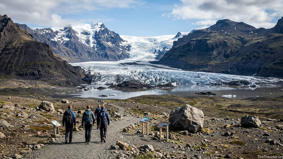
Skaftafellsjökull is one of the most accessible places in Iceland to stand face to face with an outlet glacier without committing to a technical glacier hike. Just a short, signed walk from the Skaftafell visitor centre in Vatnajökull National Park, it offers sweeping views of crevassed ice, a growing lagoon and steep mountains, all on a waymarked loop that most independent travelers can manage in under two hours.
Get the latest updates straight to your inbox!
What and Where Is Skaftafellsjökull?
Skaftafellsjökull is an outlet glacier of the vast Vatnajökull ice cap in southeast Iceland. It flows south from the Öræfajökull volcano and ice dome toward the lowlands at Skaftafell, carving a broad U-shaped valley between dark volcanic peaks. Like many of Iceland’s glaciers it has retreated significantly in recent decades, leaving behind a proglacial lagoon and wide foreland of moraines, river channels and bare rock that visitors cross on the main viewpoint trail.
Geographically, Skaftafellsjökull sits directly north of the Skaftafell visitor area beside Iceland’s Ring Road, roughly midway between Vík í Mýrdal and Höfn. To the east and west, several other glacier tongues pour off the same ice cap, including Svínafellsjökull, Falljökull and Virkisjökull. All are part of Vatnajökull National Park, but each has slightly different access, terrain and commercial use, which is important for travelers deciding where to walk, photograph or book guided tours.
Today Skaftafellsjökull is primarily a viewing destination reached on foot from Skaftafell, not a glacier used for standard guided walks. Tour operators based at Skaftafell currently run their crampon-and-rope glacier hikes on neighboring outlet glaciers such as Falljökull and Virkisjökull, where access routes and ice conditions are more suitable for commercial guiding. Skaftafellsjökull’s crevassed snout and growing lagoon make it a spectacular sight from a safe distance rather than a regular tour venue.
This distinction matters for planning. If your priority is to experience a glacier visually, photograph the ice and understand its retreat, Skaftafellsjökull’s marked viewpoint trail is ideal. If your goal is to step onto the ice with a harness and ice axe, you will be booking a Skaftafell-based tour that actually operates on a different glacier tongue nearby, and you will need to follow the operator’s instructions for check-in and transport.
How Skaftafellsjökull Relates to Skaftafell and Other Glaciers
Skaftafell itself is a compact visitor hub inside Vatnajökull National Park, with a main car park, campsite, service buildings and the Skaftafellsstofa visitor centre. From this base you can reach several well-known short hikes, including the waterfall trail to Svartifoss and the S1 trail to Skaftafellsjökull. The glacier tongue rises immediately north of the visitor area, and on clear days its broken ice and surrounding peaks are visible even from the parking lots.
To the east of Skaftafellsjökull lies Svínafellsjökull, once a popular filming location and glacier-hiking destination. Due to documented rockfall and landslide risk from the steep mountain above its western margin, Civil Protection authorities and the national park have advised against commercial glacier tours there, and operators have largely shifted their activities elsewhere. This is one reason Skaftafell’s guided glacier products now focus on other outlets rather than on Svínafellsjökull or Skaftafellsjökull themselves.
Southwest of Skaftafellsjökull, the outlet glaciers Falljökull and Virkisjökull descend from the same ice cap and are currently the main venues for guided glacier walks and seasonal ice cave tours leaving from Skaftafell. Tours typically meet near the Skaftafell service area and then transfer guests in minibuses or modified vehicles to trailheads closer to these glacier snouts. For independent travelers, it is helpful to picture Skaftafell as a central base, with Skaftafellsjökull as the most obvious self-guided viewpoint walk and Falljökull or Virkisjökull as the guided-hike destinations you reach with a tour company.
All of these outlet glaciers demonstrate the rapid changes affecting Iceland’s ice. Aerial photographs and scientific monitoring show Skaftafellsjökull retreating and thinning, with its terminus lakes expanding over the last few decades. Walking the S1 trail, you cross former glacier beds and moraines where interpretive signs often explain how far the ice has shrunk in a human lifetime, placing today’s views in a wider environmental context.
Getting to Skaftafell on the Ring Road
Skaftafell is directly accessed from Iceland’s Route 1, the Ring Road, and is straightforward to reach by rental car in normal conditions. From Reykjavík, the drive is long but scenic along the South Coast. In dry summer conditions, most drivers should allow at least 4.5 to 5 hours of pure driving time for the approximately 325 to 330 kilometer journey, not counting stops for fuel, food or sightseeing at waterfalls such as Seljalandsfoss or Skógafoss along the way.
From Vík í Mýrdal, a common overnight base, Skaftafell lies roughly 140 kilometers to the east along Route 1. The drive usually takes around 2 to 2.5 hours, depending on weather, traffic and photo stops on the black sand plains. From Höfn, a small fishing town and gateway to the eastern side of Vatnajökull, Skaftafell is about 135 to 140 kilometers to the west, again usually 2 to 2.5 hours of driving in good conditions. In winter, or during heavy rain and wind, it is sensible to build extra margin into these estimates.
There are no fuel pumps at Skaftafell itself, so drivers need to plan fuel stops in nearby settlements. To the west, Kirkjubæjarklaustur is a practical refueling and grocery stop before the long stretch across the Skeiðarársandur outwash plains. To the east, Freysnes and then Höfn offer services at greater intervals. Before setting off, it is wise to check current road and weather conditions through Iceland’s official road information channels, and to start the day with enough fuel that you are not forced to hunt for a station late at night or in bad weather.
The entrance to Skaftafell is clearly signposted from Route 1 with the national park emblem and a short access road leading to the main parking and visitor area. Standard passenger cars are sufficient in all seasons when the road is open, and there is no need for gravel-road driving or special vehicle clearances to reach the Skaftafell car parks themselves.
Finding the S1 Glacier Trail to Skaftafellsjökull
The main marked route to Skaftafellsjökull is the S1 trail, often named Jökulslóð. It begins near the Skaftafell visitor centre, Skaftafellsstofa, in the heart of the service area. Signs and simple trail maps around the visitor buildings point you toward the start, which initially follows level paths across the glacier foreland before looping back toward the car park. The route is designed as a straightforward walk rather than a technical hike, with clear waymarking and low overall elevation gain.
Recent trail descriptions list the S1 Skaftafellsjökull loop at about 4.1 kilometers in length, usually completed in roughly 1 to 1.5 hours by visitors in reasonable weather. Surfaces are a mixture of compacted earth, gravel, and some rockier sections, reflecting the moraines and sediments left behind by the retreating glacier. While the trail is generally graded easy in snow-free conditions, it still demands proper footwear and basic outdoor awareness, especially when conditions are wet or windy.
As you approach the viewpoint area near the glacier lagoon, the marked path leads to low bluffs and viewpoints overlooking the ice and lake. Fences or ropes may be present in some places to keep visitors back from unstable ground, calving ice fronts and sudden waves generated when blocks of ice fall into the water. Respecting these limits is essential for safety; attempting to cut down to the shoreline or walk closer to the ice is strongly discouraged by park staff.
Before setting out, check the latest trail information at the Skaftafell visitor centre or on current national park notice boards. Trails can be temporarily closed or rerouted because of rockfall, flooding, snow or maintenance work, and viewpoint access may occasionally be restricted to reduce risk near the lagoon. Rangers on duty are the best source for up to date advice on which sections are open on the day of your visit.
Parking, Fees and Facilities at Skaftafell
Skaftafell has a sizable parking area next to the visitor centre and campsite, and vehicles stopping here are subject to a regional parking fee that helps fund national park services. The system uses camera enforcement that records number plates at entry and exit, and travelers are expected to pay for their stay even if they only parked for a short period. Charges and rules can change, so visitors should always confirm current day rates, vehicle categories, payment methods and grace periods through official park information just before their trip.
Payment is typically handled through self-service machines and common mobile payment platforms, which allow you to enter your license plate and pay by card. Rental car drivers should pay particular attention to signage and instructions, as unpaid fees can lead to fines that are passed on by rental companies with additional handling charges. If in doubt, ask at the visitor centre desk how to correctly register your parking before you head off on the trail.
The Skaftafell visitor area functions as a compact service village within the national park. Facilities usually include the Skaftafellsstofa visitor centre with interpretive displays and information, staffed information desks, toilets, water points and a campsite with its own amenities. There are often small seasonal food options such as kiosks or food trucks during the busier months, as well as simple provisions like snacks and hot drinks, but year to year details and opening dates can vary.
Opening hours for the visitor centre, toilets and any staffed services depend heavily on the season, with longer hours in summer and more limited access in late autumn and winter. Before relying on Skaftafell for supplies or indoor shelter outside the main summer period, check the current year’s official schedule and be prepared with your own water, snacks and warm clothing in case facilities are closed or operating on reduced hours when you arrive.
When to Visit and What Conditions to Expect
Late spring through early autumn is generally the most comfortable period to walk the Skaftafellsjökull trail. From about May through September, south Iceland benefits from long daylight hours, relatively mild temperatures by local standards and mostly snow free lower trails. During this period, most visitors complete the S1 loop in light layers, a windproof shell and sturdy walking shoes or hiking boots, often combining the glacier viewpoint with another short walk such as the popular route to Svartifoss.
Outside the main season, Skaftafell and its trails can feel far wilder. In winter, snow, ice and high winds are more likely, and daylight is limited, particularly around December and early January. The S1 trail may become slippery or partially snow covered, and sections can be temporarily closed or require more time and care than in summer. Even in shoulder seasons, weather systems from the Atlantic can bring heavy rain, low cloud and poor visibility that obscure glacier views entirely, so having flexible expectations and a backup plan for your day is wise.
Time of day also influences the experience. Morning visits often feel quieter, especially before the main wave of tour departures and bus groups arrives, while late afternoon and evening in summer can offer softer light over the ice and mountains. However, if you are continuing a long drive the same day, balance the desire for golden-hour photography with the need to avoid driving tired late at night on unfamiliar roads.
Icelandic weather is famously changeable, and Skaftafell’s open foreland can be exposed to strong gusts, rain and sudden temperature drops even on days that began calm and bright. Travelers should bring layered clothing, a waterproof jacket, insulating mid layers, a hat and gloves in all seasons, and ensure that footwear has enough grip for wet gravel and uneven ground. Treat the S1 route as an easy but genuine outdoor excursion rather than an urban stroll.
Staying Safe Near Skaftafellsjökull
Although the S1 trail is graded easy, Skaftafellsjökull is still an active glacier and its surroundings demand respect. The national park repeatedly emphasizes that visitors should stay on marked paths, obey signs and keep back from the glacier’s edge and lagoon. Calving ice, falling rocks and sudden waves make the immediate shoreline hazardous, and apparently solid ground near the water can in fact be undercut or unstable after floods and ice movement.
Attempting to step onto the glacier without a certified guide, proper equipment and up to date knowledge of crevasse patterns is strongly discouraged. Skaftafellsjökull’s lower ice is heavily crevassed and intersected by meltwater channels, with hidden holes and weak snow bridges in colder months. This is one reason why commercial glacier walks from Skaftafell are routed to other outlets where guides can better manage terrain and risk.
Weather-related hazards also play a role. Strong winds can make exposed sections of the foreland uncomfortable or even dangerous, as gusts can affect balance on uneven ground or blow gravel and dust. Heavy rain can swell streams, create muddy sections and reduce traction underfoot. In winter and early spring, ice on the trail can require traction devices and more cautious footwork, and frostbite or hypothermia can become concerns if visitors are not adequately dressed.
Before setting out, check for any current trail closures, route diversions or safety notices posted by Vatnajökull National Park. Rangers and information staff can advise you if there have been recent rockfalls, flooding or other incidents affecting access to the main viewpoints. Build enough time into your schedule to turn back if conditions deteriorate, and always let weather and official advice guide your decisions more than a fixed plan or schedule.
Skaftafellsjökull vs Other Easy Glacier Viewpoints on the South Coast
For travelers driving the South Coast, Skaftafellsjökull is one of several relatively accessible glacier viewpoints. Farther west, Sólheimajökull offers a short walk from a parking area to the snout of another outlet glacier, with both independent viewpoints and a concentration of guided glacier hiking providers. Closer to Jökulsárlón, parking areas and short paths lead to viewpoints over Breiðamerkurjökull and its famous glacier lagoon, where icebergs drift out to sea and boat tours operate in season.
Each of these locations offers a distinct experience. Sólheimajökull is closer to Reykjavík and Vík, making it a convenient half-day stop for travelers who may not reach as far as Skaftafell, but it can feel busier, with more concentrated tour activity. Jökulsárlón and its neighboring Diamond Beach provide dramatic lagoon and coastline scenes, but there is no marked trail equivalent to Skaftafell’s S1 loop that lets you read the glacier’s retreat across a broad foreland in quite the same way.
Skaftafellsjökull’s strength lies in its combination of an easy, waymarked walking circuit directly from a national park visitor hub and the possibility to link it with other short hikes like Svartifoss or Skaftafellsheiði. You can park once at Skaftafell, visit the information centre, use facilities and then tailor a few hours of walking to the conditions and energy levels in your group, seeing both ice and waterfalls without moving the car.
It is important to remember that “Skaftafell glacier hikes” sold by tour companies generally take place on Falljökull or another nearby outlet, even though they meet at Skaftafell. Skaftafellsjökull itself is your self-guided viewing walk, while organized glacier hiking means booking with a licensed operator and following their instructions for the specific glacier and departure time stated in your confirmation.
Who Skaftafellsjökull Suits and How Long to Allow
The Skaftafellsjökull viewpoint walk is particularly well suited to self-driving travelers on the Ring Road who want an up close glacier experience without booking a technical tour. Families with school-age children, photographers wanting landscape compositions of ice and mountains, and travelers who are unsure about walking on crampons or committing half a day to a guided glacier hike will all find the S1 loop an appealing compromise.
Physical demands are modest for most visitors in good weather. The loop’s approximate 4.1 kilometers, gentle gradients and clear waymarking make it manageable for anyone comfortable with a one to two hour countryside walk on uneven ground. Those with limited mobility or very young children may still prefer to turn around at one of the earlier viewpoints rather than completing the full loop, and should talk to visitor centre staff about current trail conditions before venturing far.
Within a wider South Coast itinerary, it is sensible to reserve at least two to three hours at Skaftafell if you plan to walk the Skaftafellsjökull trail at a relaxed pace, allow time for photo stops and make use of facilities. If you also want to visit Svartifoss or explore additional viewpoints, half a day quickly fills up. Travelers combining Skaftafell with a same day drive from Reykjavík or to Höfn should be realistic about driving times, daylight and fatigue, and may find it more enjoyable to stay overnight nearby.
For many, Skaftafellsjökull becomes a highlight of their Ring Road journey: the moment when the abstract idea of Vatnajökull as “Europe’s largest glacier” turns into a tangible wall of ice framed by black peaks and a silent lagoon. With a bit of planning, attention to safety and up to date information from park authorities, it is an experience that fits neatly into a self-guided itinerary without the need for ropes or crampons.