


The south side of Vatnajökull around Skaftafell offers a cluster of glacier tongues within a short drive of each other, all reachable on brief walks from the Ring Road. For travelers planning a South Coast or Ring Road itinerary, the challenge is less about finding glacier views and more about choosing which viewpoints and short trails to prioritize, especially when time, daylight or group fitness levels are limited.
Get the latest updates straight to your inbox!
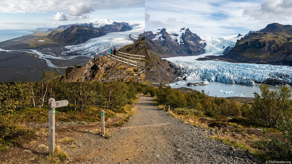
Understanding the Skaftafell Glacier Landscape
Vatnajökull, Europe’s largest ice cap, spills into multiple outlet glaciers along Iceland’s south coast, and several of the most accessible lie within a half-hour radius of Skaftafell. Skaftafellsjökull and Svínafellsjökull are two of the closest, but Falljökull, Virkisjökull and the broader Skeiðarárjökull and Öræfajökull landscape all shape what you see from viewpoints and roadside stops. From the Skaftafell visitor area, you can look inland to walls of ice and peaks; from Route 1, your views stretch across black sand plains toward gleaming glacier tongues in the distance.
Access patterns differ from glacier to glacier. Skaftafellsjökull is reached on a signed, groomed trail from within Vatnajökull National Park, with formal parking and clear waymarking. Svínafellsjökull, by contrast, sits at the end of a rougher side road off Route 1 and has been the subject of ongoing hazard assessments because of potential rockslides from the surrounding slopes. Other viewpoints, such as Sjónarnípa on the Skaftafell heights or roadside pullouts facing Skeiðarárjökull, offer wider panoramas but require either more effort or a willingness to settle for distant views.
For trip planners, the key point is that you do not need to visit every glacier tongue to feel the scale of Vatnajökull. With realistic expectations about walking distance, trail conditions and seasonal daylight, you can combine one or two viewpoints into a satisfying half-day or full day around Skaftafell without rushing or compromising on safety.
Skaftafellsjökull via the S1 Trail: The Classic Easy Viewpoint
Within Vatnajökull National Park, the S1 Skaftafellsjökull trail is often recommended as the easiest close-up glacier view. Current park trail information describes S1 as roughly 4 km to 4.5 km out and back from the Skaftafell visitor center, usually taking about 1 to 1.5 hours for most visitors at a relaxed pace. The path undulates gently across gravel and compacted earth, with minor elevation change that most people in average condition manage comfortably.
The trail surface is generally wide and well-maintained, although sections can feel uneven or muddy after rain or during shoulder seasons. There are no steep drop-offs next to the main path, which makes it suitable for families with children who are accustomed to short walks. That said, it is not a fully paved or wheelchair-accessible route; travelers with very limited mobility may find the distance and surface challenging, especially on wet days.
Parking for S1 is straightforward. You park in the main Skaftafell visitor area, which is reached by a short paved access road from Route 1. The large formal car park usually charges a day parking fee, payable at machines or via an app, with prices and payment methods occasionally updated, so it is wise to check the latest information posted on site or from official park channels just before your trip. Because Skaftafell is a major stop on many South Coast itineraries, S1 can feel busy in the middle of the day in summer, yet you can usually find quieter moments early or late in the day.
Photographically, S1 rewards visitors with a head-on view of the Skaftafellsjökull tongue and its meltwater lagoon, framed by dark peaks and streaked ice. You will be looking at the front of the glacier at close range without stepping onto the ice itself. As the glacier has retreated in recent decades, the viewpoint now sits slightly farther from the ice margin than older descriptions may suggest, but you still experience an impressive sense of scale, with crevasses, blue stripes and moraine ridges clearly visible to the naked eye or through a moderate zoom lens.
Current Access and Safety at Svínafellsjökull
Svínafellsjökull, just east of Skaftafell, has long been promoted in guidebooks and online as an easily reached glacier viewpoint via a short gravel road off Route 1 and a brief walk to lagoon and ice views. However, recent years have seen increased concern from Icelandic authorities about the risk of landslides from Svínafellsheiði, the steep slopes overlooking the glacier. Hazard assessments by the Icelandic Meteorological Office describe the potential for large rock or debris slides into the valley, which in turn could affect anyone lingering beneath those slopes.
As of November 2026, official communications emphasize that the Svínafellsjökull area is considered a hazard zone and that visitors should be extremely cautious. Access patterns have varied over time, with some previous years seeing the former glacier hiking base closed and operators relocating tours to other glaciers. The situation is dynamic and tied to ongoing monitoring of ground movement above the glacier. At publication time, independent casual visitors driving to the end of the side road may find warning signs and barriers that restrict how far they can walk toward traditional viewpoints.
Because risk levels and access rules here are more changeable than at Skaftafell’s signed trails, it is essential to verify the latest advice shortly before visiting. Check recent statements from the Icelandic Meteorological Office and Vatnajökull National Park, along with any notices from local police or road authorities. If barriers, closure signs or hazard notices are present when you arrive, respect them fully and do not attempt to bypass fences or walk closer to the glacier along unofficial paths or the base of unstable slopes, even if you see tracks or older descriptions suggesting otherwise.
For planning purposes, assume that Svínafellsjökull viewpoints are not as reliably or safely accessible as skaftafellsjökull. The drive along the side road is often potholed and rough, better suited to drivers who are comfortable on uneven gravel rather than those in low-clearance rental cars. If conditions are favorable and local authorities still allow access to the established viewpoint area above the lagoon, the walking distance from your car will likely be short, on the order of a few hundred meters over rocky ground. Yet the higher level of uncertainty and objective hazard means this stop is best treated as optional rather than essential, particularly for cautious travelers or those responsible for less mobile members of a group.
Sjónarnípa: Panoramic Heights Above Skaftafellsjökull
While the S1 trail brings you face to face with the front of Skaftafellsjökull, the Sjónarnípa viewpoint offers a sweeping bird’s-eye perspective from above. Park trail descriptions outline the S5 route to Sjónarnípa at roughly 6.5 km round trip from the Skaftafell visitor area, with about 300 meters of elevation gain and an expected time of around 2 to 2.5 hours for most hikers. Variants that combine Sjónarnípa with Svartifoss on routes labeled S5 or S6 extend the distance to around 7 km or more and can fill a half-day when you account for photo stops.
The path climbs steady slopes on mostly firm ground, shifting from lowland scrub and birch to more open heath as you gain altitude. Under dry summer conditions, most people with moderate fitness and no mobility issues find the trail straightforward, but the combination of distance and ascent means it is more demanding than a simple stroll. In wet or icy conditions, especially outside the core summer months, footing can become slippery and extra care is needed. This is not an appropriate route for travelers with significant mobility limitations or anyone uncomfortable with prolonged uphill walking.
Parking, as with S1, is in the main Skaftafell car park, which simplifies logistics for groups considering different options: some may choose the low-level S1 viewpoint while others tackle Sjónarnípa from the same starting point. Crowd levels on the Sjónarnípa trail are noticeably lower than on the S1 or Svartifoss paths, and you will often find space at the clifftop to sit quietly and absorb the view.
From Sjónarnípa, you look down on Skaftafellsjökull from above, seeing not just the snout but much of its length as it flows out of the Vatnajökull ice cap. On clear days, views stretch across the black floodplains of Skeiðarársandur and up to surrounding peaks. Photographers value this location for its wide, layered compositions and for the chance to show the glacier in context rather than as an isolated wall of ice. The trade-off is that you lose some of the intimate ice textures visible from the S1 terminus, and those who prefer minimal walking may find the effort outweighs the extra perspective.
Other Nearby Glacier Viewpoints from the Ring Road
Beyond Skaftafellsjökull and Svínafellsjökull, the Ring Road itself delivers several impressive, low-effort glacier views within the same region. To the west of Skaftafell, viewpoints across the Skeiðarárjökull and Skeiðarársandur outwash plain offer a grand sense of scale. Here you park in formal roadside lay-bys or small paved bays, step out of the car and take in sweeping vistas of braided rivers and distant ice fronts. Walking distances are minimal, typically just a few dozen meters from the car to a guardrail or informal viewing spot, making these stops suitable for travelers with very limited mobility.
East of Skaftafell, the Ring Road passes close to other Vatnajökull outlets and lagoons, including the famous Jökulsárlón and smaller glacial lagoons near Fjallsjökull. These locations are not immediate neighbors on foot but are easily combined by car in the same day as Skaftafell. Car parks are usually formal and sometimes busy, with tour buses and boat excursion desks during the main season. Surfaces range from paved lots to compacted gravel, and walks from the vehicle to viewpoints along the lagoon edges are short and mostly flat, though not generally wheelchair-graded.
In terms of photographic character, roadside and lagoon viewpoints tend to emphasize broad panoramas, reflections and, at some sites, icebergs drifting near the shore. You are often farther from any vertical ice wall than at Skaftafellsjökull’s S1 endpoint, but you gain compositions that include water, sky and long-distance glacier tongues framed by mountain ridges. For visitors who value minimal walking and flexible timing, this pattern of short roadside stops can be an efficient way to build glacier scenery into a packed itinerary.
Because these pullouts and parking areas sit alongside a major highway, safety considerations shift from natural hazards to road awareness. Park only in designated areas, avoid crossing the roadway on blind bends, and supervise children closely when traffic is heavy. Conditions in winter can also be challenging, with snowbanks, ice and reduced visibility, so be prepared to skip viewpoints when stopping would feel unsafe.
Comparing Key Viewpoints for Different Travelers
When choosing between Skaftafellsjökull, Svínafellsjökull, Sjónarnípa and simple Route 1 stops, it helps to match each viewpoint’s demands and rewards to your group’s abilities and interests. Skaftafellsjökull via S1 suits most visitors able to walk 4 km to 5 km on an easy trail, including families with older children. It provides the closest safe approach to an ice front in this immediate area without a guide, along with clear signage, trail markers and ranger information at the visitor center.
Svínafellsjökull, in its current status, should be viewed as a higher-uncertainty option. Even if access remains physically possible, the combination of geological hazard, a rougher access road and variable on-site signage make it less appropriate for risk-averse travelers, those in rental cars with low clearance or anyone for whom sudden closure would cause major disappointment. If you are traveling with a group that includes nervous drivers, elderly relatives or small children, Skaftafell’s better-managed infrastructure generally offers a more predictable experience.
Sjónarnípa is the standout choice for those seeking a half-day hike with big panoramic payoffs. It is best for visitors who are comfortable gaining several hundred vertical meters and covering more than 6 km on trails, and who are prepared with appropriate footwear, extra layers and water. The vantage point suits photographers wanting to capture glacier, mountains and floodplains in one frame, or anyone who enjoys feeling perched between ice and lowlands.
Roadside viewpoints and nearby lagoons, finally, shine for travelers with very limited mobility or tightly packed schedules. If someone in your party uses a cane or cannot manage more than a few minutes of walking on uneven ground, combining short stops from the car with a partial attempt on the S1 trail, turning around whenever it becomes uncomfortable, may be the most realistic plan. Communicate expectations clearly within the group so that more ambitious hikers do not feel constrained and less mobile companions do not feel pressured to push beyond their comfort zone.
Staying Safe: Glacier Edges, Guided Tours and Unmarked Tracks
Across the Skaftafell region, an important safety principle applies: walking onto glacier ice or into crevassed zones is not a casual activity. Even where the front of a glacier appears smooth from a distance, hidden crevasses, unstable snow bridges and falling ice pose serious risks to unaccompanied visitors. To step onto the ice safely, you need a certified glacier guide, proper equipment such as crampons, helmets and harnesses, and up-to-date knowledge of the day’s conditions.
Many guided glacier hikes marketed as “Skaftafell glacier tours” actually operate on nearby outlets such as Falljökull or Virkisjökull rather than directly on Skaftafellsjökull. This is a practical choice by operators, reflecting which glaciers currently offer the safest and most interesting terrain for guided groups. If you book a tour, read the description carefully to see which glacier is used and where the actual meeting point lies; often you will check in at Skaftafell but then transfer a short distance by vehicle to a separate parking area closer to the chosen glacier.
Unmaintained paths and informal tracks, particularly near Svínafellsjökull and some moraine ridges, can be misleading. A boot-worn line in the gravel does not guarantee safety, since underlying hazards such as rockfall trajectories or unstable slopes may be invisible. Where official information is limited or dated, it is better to highlight uncertainty and err on the side of conservatism than to assume that what past visitors did remains wise now. Always defer to the latest guidance from park staff, the Icelandic Meteorological Office and local emergency services.
Weather and seasonal light also affect safety dramatically. In shoulder seasons and winter, icy surfaces on even easy trails like S1 can make walking treacherous without microspikes or similar traction aids, while strong winds near exposed viewpoints like Sjónarnípa can make edges feel hazardous. Plan conservative turnaround times, particularly in short winter days, and remember that cloud, rain or blowing snow can reduce visibility so much that even prominent glaciers vanish from view.
How to Choose: A Practical Comparison
For quick planning, it is helpful to think of each main viewpoint in terms of walk distance, difficulty and trade-offs. Skaftafellsjökull S1 typically involves around 4 km to 4.5 km round trip, on easy undulating terrain, with about 1 to 1.5 hours required and a well-marked path from a formal, fee-charging car park. Its strengths are close-up ice views and reliable access, with the main downsides being crowds in high season and a trail that may feel slightly long for those wanting only the briefest stroll.
Sjónarnípa, reached by routes like S5 or S6, more than doubles the effort: roughly 6.5 km to over 7 km round trip, with 300 meters or more of ascent and a 2 to 3 hour commitment. In exchange, you gain the widest panorama and a stronger sense of how the glacier integrates into the broader landscape. For many reasonably fit travelers, this is the best-value hike in the area, while for others it will simply be too demanding.
Svínafellsjökull, in theory, requires only a few minutes of walking from an informal or basic parking area at the end of a rough spur road. In calm periods and when authorities allow access to the traditional lagoon overlook, it can provide an immediate, dramatic face-on glacier view. Yet the current rockslide hazard and evolving management advice mean that travelers should treat all such details as tentative, to be confirmed as close as possible to the time of travel. In this case, the key con is the uncertainty itself, rather than the walk.
Roadside viewpoints and lagoon edges around the region usually incur the least walking effort, sometimes no more than a flat 100-meter amble from car to guardrail or shore. The costs are in reduced intimacy with the ice and, at famous sites, potentially heavy crowds and limited parking at peak hours. When building an itinerary, many travelers find it helpful to combine one more immersive walk, such as S1 or Sjónarnípa, with one or two lower-effort roadside stops that round out the sense of the greater Vatnajökull system.
Suggested Itineraries and Final Tips
For a half-day in the Skaftafell area, a realistic and rewarding combination is to walk the S1 trail to Skaftafellsjökull in the morning or late afternoon and then invest any remaining time in short roadside glacier viewpoints from Route 1. This pattern suits travelers of varied fitness, since less mobile companions can turn back partway along S1 or wait at the visitor center while others complete the walk. If daylight and energy permit, you might add a brief stop at a nearby lagoon further east for contrast.
Those seeking a more active day might pair Sjónarnípa with Skaftafellsjökull, either via a combined route that links the clifftop viewpoint with the lower glacier path or by tackling Sjónarnípa first and S1 only as far as feels comfortable. This fills much of a day when you factor in breaks, photography and time at the visitor center. If part of your group prefers a gentler program, they can remain on low-level trails or take advantage of the visitor facilities while stronger walkers head uphill.
If you are particularly interested in standing on the ice, design your day around a guided glacier hike, recognizing that you will likely be on Falljökull or a neighboring outlet rather than Skaftafellsjökull itself. Combine that tour with a short visit to the S1 viewpoint either before or after, time and weather allowing, to experience both the macro perspective and the micro textures of crevasses and seracs under professional supervision.
Finally, whatever combination you choose, build flexibility into your plans. Re-check road conditions, weather forecasts, daylight hours and any current safety advisories for Svínafellsjökull and other hazard-prone sites before setting out. In this landscape, conditions shift quickly, but by favoring well-maintained trails like S1 and Sjónarnípa, relying on official information and being prepared to alter your route on the day, you can experience the best glacier viewpoints around Skaftafell in a way that suits your group’s time, fitness and appetite for adventure.