
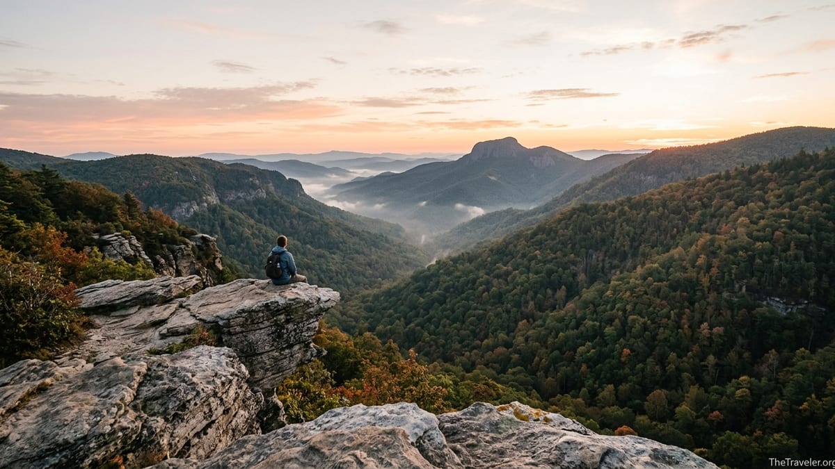
On a sunny October afternoon, the small dirt lot at the Hawksbill Mountain trailhead in North Carolina’s Linville Gorge can look more like a tailgate party than a wilderness access point. Cars squeeze onto the shoulder of Forest Service Road 210, hikers queue for a space on the rocky summit, and the famous views of Table Rock and the Linville River come with a soundtrack of conversation and camera shutters. Yet with a bit of strategy, it is still entirely possible to have Hawksbill’s 4,000-foot summit almost to yourself, even in peak season. The key is planning smarter, not farther, so you trade stress and crowds for solitude and sky-wide views.
Get the latest updates straight to your inbox!
Know Your Hawksbill: Linville Gorge vs. Shenandoah
Before you plan anything, clarify which Hawksbill you want to hike. In the eastern United States there are two well-known Hawksbill peaks that show up in the same search results: Hawksbill Mountain in North Carolina’s Linville Gorge Wilderness and Hawksbill Summit in Virginia’s Shenandoah National Park. The Linville Gorge Hawksbill sits at about 4,020 feet and is accessed from a short but steep trail off Forest Service Road 210, roughly an hour and a half from Asheville. Shenandoah’s Hawksbill is the highest point in that park at about 4,051 feet, reached from Skyline Drive via several loop options. Both offer big views and can get busy, but the logistics and crowd patterns differ.
This guide focuses primarily on Hawksbill Mountain in Linville Gorge, often called one of North Carolina’s best bang-for-your-buck hikes. The main trail is only around 2 to 2.5 miles round trip with roughly 700 feet of elevation gain, which makes it a magnet for day trippers staying in Boone, Blowing Rock, or the Asheville area. If you accidentally plug “Hawksbill Summit” into your navigation app, you may end up three hours away in Shenandoah. When you book accommodation, pull up a map and confirm you are near Linville Gorge, Pisgah National Forest, or NC Highway 181, not Skyline Drive.
If you are open to either destination, note that Shenandoah’s Hawksbill is more developed, with paved parking at Hawksbill Gap and well-signed loops, while Linville Gorge’s Hawksbill feels wilder, with a rougher forest road, no facilities at the trailhead, and a rockier, more rugged summit. For hikers seeking solitude, that wilder feel can be a big part of the appeal, provided you plan around the busiest times.
Crowd levels also differ by season. Shenandoah’s Skyline Drive sees intense foliage traffic in October and heavy weekend visitation throughout summer. Linville Gorge’s Hawksbill draws a mix of regional day hikers, backpackers, and rock climbers all year but is particularly popular on sunny weekends from late spring through fall. Knowing which destination matches your expectations for infrastructure and remoteness will shape how you avoid the crowds.
Choose Smart Timing: Seasons, Days, and Hours
The single biggest lever you have for a quieter Hawksbill hike is timing. In Linville Gorge, Saturdays between May and October are predictably busy, especially during holiday weekends and peak color in mid to late October. On those dates, expect the small Hawksbill parking area on Forest Service Road 210 to fill by mid-morning. If your schedule is flexible, plan your hike for a Tuesday through Thursday between late April and early June, or in early November after peak foliage has passed. Those shoulder periods often deliver crisp views, cooler temperatures, and significantly fewer people on the summit.
Even on busy weekends, time of day is your secret weapon. Sunrise hikers usually encounter only a handful of headlamps at the trailhead, and many report sharing the summit with fewer than ten people, even in October. Because the main trail is short and steep rather than long and committing, starting in the dark is realistic for moderately experienced hikers. For example, leaving a rental cabin in Linville at 5:30 a.m. in late September gives you enough time to drive the gravel road and begin hiking by first light. You will typically be back to your car by 9 a.m., just as the main wave arrives.
Sunset is another crowd-thinning tool, though it comes with a steep hike down by headlamp. On a July Saturday, hikers who start up around 6:30 p.m. will often pass a steady stream of people leaving the summit, then share the last light with a much smaller group. If you are comfortable descending steep, rocky trail in the dark with good headlamps and extra batteries, this can be a satisfying way to trade the lunch crowd for golden-hour light over Table Rock and the Linville River.
Weather can also work in your favor. Many day trippers avoid cool, breezy days or dates with a low chance of showers, but Hawksbill’s views are often clearest after a cold front sweeps out haze. If you are properly equipped with a windproof layer and a pack cover, a forecast of cool temperatures and mixed clouds can translate into a quieter summit and dramatic cloud shadows moving across the gorge. Always avoid thunderstorms or high wind warnings; the summit’s exposed rock slabs and sheer cliffs are no place to gamble with lightning.
Beat the Parking Lot Rush: Access, Roads, and Alternatives
Crowding at Hawksbill often starts not on the trail but on the narrow forest road that leads to it. The standard access is via Forest Service Road 210 (sometimes signed as Gingercake Road turning to gravel), a graded but occasionally rutted road that winds along the east rim of Linville Gorge. In dry conditions, most standard sedans can reach the Hawksbill trailhead, but after heavy rain, potholes deepen, and low-clearance cars may need to pick their way slowly. The actual parking area is a small dirt pullout that comfortably holds a dozen or so vehicles. By late morning on popular weekends, extra cars line the roadside, sometimes creating tight squeezes for through traffic.
To sidestep that bottleneck, treat parking like a limited resource and plan to be parked before 8 a.m. on any weekend from May through October. If you are coming from Asheville or Morganton, build in extra time for a quick stop in town for fuel and last-minute snacks so you are not delayed on the narrow mountain roads. If you arrive to find the lot full, resist the temptation to block driveways, gates, or vegetation. Instead, continue along Forest Service Road 210 and look for a safe, legal pullout where your vehicle is completely off the travel lane. You may add a quarter mile of walking, but you will avoid the stress of questionable parking and potential towing or tickets.
Consider pairing Hawksbill with other rim viewpoints to distribute your time and avoid peak congestion at any single spot. Wiseman’s View, for example, is accessed via another rough gravel road from NC 105 but offers paved walkways to stone overlooks, making it friendlier for less mobile companions. Table Rock Mountain, a short drive farther along Forest Service Road 210, has its own trailhead and parking area. On a busy Saturday, an efficient strategy might be to hike Hawksbill at sunrise, then relocate to Wiseman’s View or Table Rock for a midday picnic while the Hawksbill lot is at its fullest, returning to Hawksbill’s area only to drive out.
If the weather or road conditions make the main Hawksbill trailhead inconvenient, remember that the Linville Gorge Wilderness has a network of steep, rugged trails along both rims and down into the gorge. With a detailed topographic map or a reputable guidebook purchased in Asheville or online before your trip, you can pick alternative hikes with comparable views but fewer people, using Hawksbill as only one anchor point. This flexible approach avoids the sunk-cost frustration of insisting on the summit even when it is clearly overcrowded or unsafe to access.
Use Routes and Micro-Choices to Find Solitude on the Summit
Even if you arrive during a busy window, you can still carve out pockets of quiet with smart on-trail decisions. The main Hawksbill Mountain path in Linville Gorge climbs steadily through forest before splitting into spur paths over rocky terrain near the summit. Many visitors stop at the first big overlook they reach, especially if they are winded from the climb. By continuing along the rocky spine another couple of minutes, you may find secondary outcrops with nearly the same view but far fewer people. It is common on summer weekends to see twenty or thirty hikers clustered on the central slabs while only one or two are tucked onto side ledges with equally expansive vistas.
When the summit is crowded, slow down and watch how groups move. Families with children tend to take photos quickly and leave; photographers may linger in one spot but will usually step aside if you wait a moment instead of squeezing past. Carrying a lightweight sit pad or small camp chair lets you settle on a less popular rock and enjoy the scene without needing prime real estate at the edge. On a clear spring morning, for example, you might take in sunrise over the gorge from a slightly recessed perch, then wander out to the main rim for a few minutes only after the initial rush of selfies subsides.
If you are comfortable with navigation and have solid footwear, explore short social paths that branch off the main summit area, but only where the rock is durable and there is no risk of disturbing fragile vegetation. Many climbers and experienced locals use these side paths to reach different viewpoints of the gorge or Table Rock. Stay well back from cliff edges, especially when the rock is damp or the wind is strong, and avoid any route that feels like a scramble beyond your comfort level. Solitude is not worth a fall, and loose rock is common around the cliff bands.
In Shenandoah, where Hawksbill Summit is served by multiple loop routes from Skyline Drive, a similar principle applies. The Upper Hawksbill Trail, Lower Hawksbill Trail, and Appalachian Trail connectors converge near the summit. Most day hikers follow the shortest out-and-back route, so choosing a slightly longer loop, such as combining the Appalachian Trail with one of the Hawksbill spurs, often yields quieter stretches of trail while still delivering the same summit lookout and stone-built viewing platform.
Plan Permits, Camping, and Overnight Strategies
While day hiking to Hawksbill’s summit in Linville Gorge does not currently require a reservation, overnight use inside the Linville Gorge Wilderness is managed with free permits during the busy season. The United States Forest Service typically requires overnight permits for trips that include Friday or Saturday nights and certain holidays between May and October, with a cap on the number of parties allowed per night to protect the fragile environment. Permits can be reserved in advance through official channels, or in some cases picked up at the Linville Gorge Information Cabin when it is staffed. Because policies can change, check the Grandfather Ranger District or Recreation.gov shortly before your trip for the latest rules rather than relying on outdated blog posts.
If your goal is to camp near Hawksbill for sunrise or sunset photography with fewer people around, decide whether you will camp within the wilderness boundary or outside it. Inside the wilderness, expect stricter rules about campfire use, group size, and distance from trails and water sources. You will need to study current maps that clearly show the wilderness boundary and avoid camping within 200 feet of designated trails such as Hawksbill and others where camping is prohibited close to the path. In practical terms, this often means carrying your overnight gear deeper into the forest or down connector trails rather than pitching a tent right off the summit spur, which is both fragile and heavily trafficked.
Many hikers aiming for a quasi-sunset or sunrise experience opt to stay in established campgrounds outside the wilderness, then drive to the Hawksbill trailhead at odd hours when crowds are thin. For instance, Linville Falls Campground off the Blue Ridge Parkway offers reservable sites with picnic tables and access to potable water during its operating season. A couple staying there in midsummer might budget around 25 to 40 dollars per night for a standard campsite, then make a pre-dawn drive of about 30 to 40 minutes to reach Forest Service Road 210. This approach trades the romance of backcountry camping for the convenience of secure parking, known water sources, and a simpler logistics chain.
Dispersed roadside camping along Old NC 105 and other forest roads near Linville Gorge is another option, but regulations are patchwork and change over time. Some pullouts allow car camping without permits because they sit outside the wilderness boundary, while others are restricted. Rangers periodically adjust rules to address erosion, trash, and unauthorized fire rings. If you plan to use dispersed sites, stop at a ranger station or the Linville Gorge Information Cabin for the most up-to-date guidance, and always have a backup plan, such as a commercial campground in Marion or a cabin rental on NC 181, in case your preferred roadside pullout is closed or already occupied.
Gear, Safety, and Low-Impact Habits That Keep the Experience Wild
A crowded-feeling summit often has as much to do with behavior as with headcount. Thoughtful gear choices and low-impact habits can make Hawksbill feel quieter and more remote, even when others are on the trail. Start with essentials: sturdy hiking shoes with good traction for the steep, sometimes loose sections; at least one liter of water per person for this short hike, more in summer; and layers for wind and sudden temperature changes on the exposed summit. Many visitors underestimate how much cooler it can be at 4,000 feet compared to the trailhead, and leave early because they did not pack a fleece or shell.
Navigation tools are another way to reduce stress. Download offline maps from a trusted hiking app before leaving cell service, and carry a paper map of the Linville Gorge Wilderness as backup. The main Hawksbill trail is generally clear, but unmarked side paths and junctions can confuse tired hikers on the descent. On busy days, following a crowd blindly can lead to wrong turns when another group heads to a different overlook or back to an alternate parking area. A quick glance at your own map avoids a domino of confusion and lets you confidently pause to let louder groups get ahead of you, widening the sound buffer on trail.
Noise management is critical if your goal is solitude. Avoid portable speakers, keep group conversations at a low volume, and resist the urge to share videos on full speaker at the summit. If you are visiting with children or a group of friends, set expectations before you start hiking: agree to quiet moments on the final approach to the summit and while people are taking in the view. Many hikers choose Hawksbill specifically for a sense of awe and silence. By modeling respectful behavior, you help maintain that atmosphere, and you may find that others follow your lead.
Finally, embrace the Leave No Trace ethic that underpins the wilderness experience. Pack out all trash, including fruit peels and snack wrappers, use restrooms before driving up the forest roads because there are no facilities at the trailhead, and avoid stepping on fragile plants near the cliffs just for a better selfie angle. When you minimize your own impact, land managers are less likely to impose stricter quotas or closures in the future, which keeps access flexible for early birds and creative planners trying to escape the crowds.
The Takeaway
Hawksbill Mountain’s popularity is not an accident. The hike in Linville Gorge is short, the views are enormous, and the access from Western North Carolina’s vacation towns is relatively straightforward. That combination guarantees crowds on certain days, but it does not mean you have to accept a shoulder-to-shoulder summit. By understanding the difference between the North Carolina and Virginia peaks, timing your visit for shoulder seasons or off-peak hours, arriving early enough to beat the parking crunch, and using small on-trail decisions to seek out alternate perches, you can recapture the sense of wildness that first made Hawksbill famous.
Layer in savvy overnight planning, respect for evolving permit rules, and a commitment to quiet, low-impact hiking, and you will discover that the smartest way to experience Hawksbill is not to search for some secret new trail. It is to use the existing routes with intention. With the right plan, you will watch the first light hit Table Rock or the last glow fade over the Linville River with only a few other silhouettes on the horizon, while the busiest hours of the day come and go far below you on the gravel road.
FAQ
Q1. Do I need a permit to day hike Hawksbill Mountain in Linville Gorge?
For a standard day hike to Hawksbill’s summit in Linville Gorge, you typically do not need a permit. Permits are usually required only for overnight camping inside the wilderness during busier months, but you should always confirm current rules with the United States Forest Service shortly before your trip.
Q2. What is the best time of day to avoid crowds on Hawksbill?
The quietest times are usually sunrise and late evening. Starting before dawn to catch first light, or beginning your hike a couple of hours before sunset, often means sharing the trail and summit with far fewer people than at midday.
Q3. How difficult is the Hawksbill Mountain trail in Linville Gorge?
The hike is relatively short, around 2 to 2.5 miles round trip, but it is steep and rocky, with roughly 700 feet of elevation gain. Most reasonably fit hikers can complete it in one to two hours, yet the grade and footing make it feel more strenuous than the mileage suggests.
Q4. Can a regular car make it to the Hawksbill trailhead on Forest Service Road 210?
In dry conditions, most standard cars can reach the Hawksbill trailhead, although the last stretch is gravel with occasional potholes. After heavy rain or winter storms, the road may be rougher, and drivers of low-clearance vehicles should proceed slowly and be prepared to turn around if conditions feel unsafe.
Q5. What should I pack for a shoulder-season Hawksbill hike?
Plan on sturdy footwear, at least a liter of water per person, a warm layer and windproof shell for the summit, a headlamp with spare batteries if there is any chance you will be hiking in the dark, and a paper or offline digital map of Linville Gorge. In spring and fall, temperatures can drop quickly near the summit, even on sunny days.
Q6. Are dogs allowed on the Hawksbill trail in Linville Gorge?
Leashed dogs are generally allowed on national forest trails, including Hawksbill, but owners should be prepared for steep, rocky sections and exposed cliffs near the summit. Keep pets on a leash, manage them closely around other hikers, and carry out all waste to help protect the area.
Q7. How can I combine Hawksbill with other nearby hikes to spread out the crowds?
Many visitors pair Hawksbill with nearby viewpoints such as Table Rock Mountain or Wiseman’s View. For example, you might hike Hawksbill at sunrise, then drive to Table Rock for a shorter midday walk, or visit Wiseman’s View’s easy overlooks while the Hawksbill parking area is most congested.
Q8. Is camping on or near the Hawksbill summit allowed?
Camping directly on the summit or close to heavily used parts of the trail is discouraged or prohibited to protect fragile terrain and maintain safety. If you plan to backpack in the Linville Gorge Wilderness, you will typically need an overnight permit in peak season and must camp away from designated trails and water sources, following current Forest Service regulations.
Q9. How do weather and seasons affect crowd levels on Hawksbill?
Saturdays and holidays from late spring through fall are the busiest, with peak visitation during October’s leaf season. Cooler weekdays in spring, early summer, and late fall generally see lighter traffic, and slightly overcast but stable weather days often deter casual visitors while still providing good views for prepared hikers.
Q10. What is the main difference between Hawksbill in Linville Gorge and Hawksbill in Shenandoah?
Hawksbill in Linville Gorge offers a shorter, steeper hike in a wilder, less developed setting accessed by gravel roads, while Hawksbill Summit in Shenandoah National Park is reached via well-marked trails from Skyline Drive with paved parking and more infrastructure. Both can be crowded, so it is important to verify which one you intend to visit and tailor your timing and expectations accordingly.