
From the moment the trees parted and the rock ledge of Hawksbill’s summit came into view, it felt less like finishing a short hike and more like stepping onto the roof of Virginia. Far below, the Shenandoah Valley spread out in soft greens and patchwork fields, while the Blue Ridge rippled away in waves of blue. Reaching the highest point in Shenandoah National Park might not require a grueling expedition, but standing on Hawksbill’s crown delivers the kind of perspective that can redefine a visit to the Virginia mountains.
Get the latest updates straight to your inbox!
Meeting Virginia’s High Point in Shenandoah
Hawksbill Mountain rises to a little over 4,000 feet, making it the highest peak in Shenandoah National Park and one of only two summits in the park that break the 4,000-foot mark. Even if you have driven the length of Skyline Drive and taken in dozens of overlooks, the first time you step onto the stone observation platform on Hawksbill the view feels different. You are no longer looking at the mountains; you are in the middle of them, level with the ridgelines instead of gazing up from the road.
The mountain straddles the line between Madison and Page counties, roughly in the central district of the park. On clear days, visitors can trace the broad valley of the Shenandoah River to the west and the rolling hills of the Virginia Piedmont to the east. It is common to hear hikers around you quietly naming what they see: Massanutten Mountain slicing down the middle of the valley, the town of Luray a scattered cluster in the distance, or the bulk of Old Rag off to the east.
Part of what makes Hawksbill feel so accessible is the way Skyline Drive does much of the work before you even lace your boots. The road itself stays high, so most routes to the summit involve less than 900 feet of elevation gain and can be completed in one to three hours. That combination of “highest peak in the park” and “doable before lunch” is why many travelers plan their Shenandoah itinerary around this one summit, even if they are only in the park for a single day.
Despite the relative ease, the mountain’s upper slopes still feel alpine by Virginia standards. In summer, the air on the summit can be noticeably cooler than at the Big Meadows campground or the valley farms below, and in fall the wind can cut through a light jacket quickly. The sense of being just a little closer to the sky is what makes the phrase “standing on top of Virginia” feel less like a cliché and more like an honest description.
Choosing Your Route: Three Classic Ways Up Hawksbill
Most visitors reach Hawksbill using one of three well-established routes: the steep and direct Lower Hawksbill Trail from Hawksbill Gap, the more gradual Upper Hawksbill Trail from a higher parking area, or a longer loop that connects several paths into a modest half-day circuit. Which you choose will shape your experience long before you see the summit rocks.
The Lower Hawksbill Trail leaves from Hawksbill Gap parking around mile 45.5 of Skyline Drive. This path is short, roughly 1.7 miles out and back, but it gains nearly 700 feet in that distance. For many day trippers who have just driven up from Washington, D.C. or Charlottesville, it can feel surprisingly steep. Stone steps, rocky sections, and consistent uphill grade make it a moderate workout, yet most reasonably fit hikers can reach the top in 40 to 60 minutes. Families often choose this route when they want a quick payoff and do not mind stopping for breath along the way.
The Upper Hawksbill Trail begins from a small lot near mile 46.7. This option is slightly longer, around 2.1 miles round trip, but it spreads the elevation gain over more distance. The result is a steadier, more gentle ascent through a quiet forest, with sections along an old fire road. It suits hikers who prefer a less intense climb or who are bringing older relatives who want the summit experience without feeling rushed. On busy weekends in October, when the lower parking lot can overflow by mid-morning, this upper lot sometimes offers a better chance of finding a legal space without circling repeatedly.
For visitors with a bit more time, a roughly 3-mile loop starting and ending at Hawksbill Gap gives a fuller taste of the mountain. By linking the Lower Hawksbill Trail, the Appalachian Trail, and the Salamander or Hawksbill Summit Trail, you can turn the outing into a circuit that passes through mixed hardwood forest, skirts rock outcrops, and returns along the park’s most famous long-distance footpath. Hikers who track their efforts on fitness watches often log around 800 to 900 feet of total elevation gain on this loop, enough to feel like a genuine mountain hike but still manageable between breakfast at Big Meadows Lodge and an afternoon drive to other viewpoints.
On the Trail: What the Climb Really Feels Like
Even though the numbers make Hawksbill sound straightforward, the actual experience on the trail changes dramatically with the season and time of day. Starting on a cool June morning, the lower sections of the trail often feel like a deep green tunnel. Ferns crowd the sides, and small songbirds skitter from branch to branch ahead of you. When fog settles in the valley, it sometimes spills over the ridge, so the woods take on a muted, almost coastal feel, with droplets forming on spider webs and jacket sleeves.
The switchbacks on the Lower Hawksbill route are where many hikers first realize that “moderate” in guidebook language still means work. It is common to see groups take short breaks by boulders, sipping water from reusable bottles and comparing the climb to stair workouts back home. Parents coax children with promises of snacks at the top, while college students from nearby Harrisonburg or Charlottesville stride past with trail-running shoes and small daypacks, aiming to be on and off the mountain in under an hour.
On Upper Hawksbill, the journey tends to be quieter. The old fire road provides a wider tread, and there are long straight stretches where you can find your rhythm and let your thoughts wander. In late September, the forest here can erupt in color, with maples turning red and oaks shifting toward gold. That is when you are most likely to meet amateur photographers pausing to frame the play of light on the leaves, large DSLR cameras bouncing on their chests, or travelers from overseas who discovered Hawksbill from a short mention in an in-flight magazine.
As you approach the top from either direction, the trees give way to scattered shrubs and low-growing plants adapted to the harsh conditions on exposed rock. In winter, the winds can be fierce enough to push fine ice across the trail, while in summer the midday sun beats directly onto the stone. The last few yards, which lead to the observation platform and nearby rocky ledges, often feel like a natural threshold. Many hikers unconsciously slow down, as if stretching out the moment before the view appears.
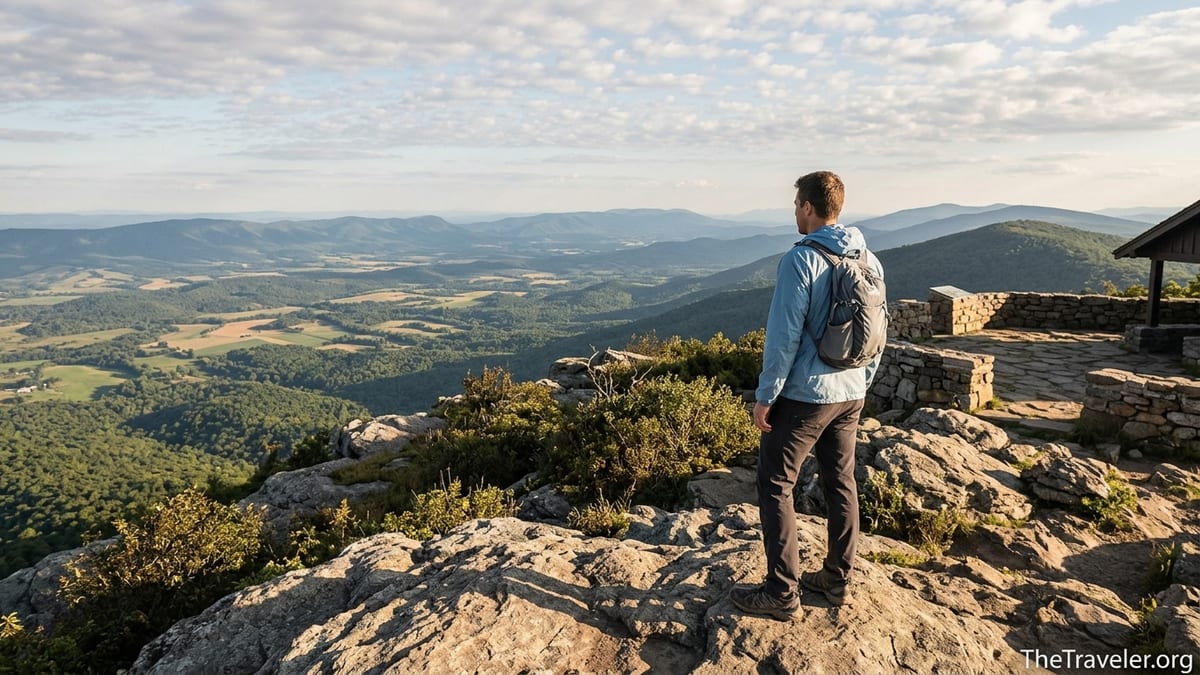
Summit Moments: 360 Degrees of Virginia
The first full look from Hawksbill’s summit is often followed by a moment of quiet, even on busy days. Facing west, the Shenandoah Valley unfurls in geometric patterns of farm fields, with Massanutten Mountain forming a long, forested wall beyond. To the south, the Blue Ridge undulates in parallel ridges, each slightly fainter than the last, fading into a soft blue haze. When thin clouds race overhead, shifting patches of sunlight wander across the landscape like moving spotlights.
Turn east, and the character of the view changes. Here, the land drops more steeply toward the Piedmont, and on particularly clear days visitors can trace the outline of the foothills that eventually roll toward Charlottesville and the outskirts of the Washington metropolitan area. The sense of being poised between two different Virginias is tangible: rural valley farms on one side, denser development far beyond the horizon on the other. It is this dual perspective that makes hikers describe the experience as standing not just on top of Shenandoah, but on top of the state.
Practical realities ground the scene. There is a sturdy stone viewing platform built by the park, with low walls where children can safely peer over the edge. Nearby, the Byrds Nest shelter, a simple stone hut with a fireplace and picnic tables, gives hikers a spot to sit out sudden showers or escape a stiff wind. On most weekends from late spring through fall, it is common to find a handful of people stretched out on the flattest rocks, boots off, eating trail mix or foil-wrapped sandwiches bought that morning from the Big Meadows Wayside.
Wildlife adds its own punctuation. Small birds often hop around the edges of the platform, hoping for crumbs, while dark-eyed juncos dart between shrubs. In summer, the high-elevation vegetation can host butterflies and bumblebees, and if you are very fortunate you may see peregrine falcons riding the air currents along the cliffs, part of an ongoing restoration effort in this part of the park. The combination of sweeping human-made vistas and delicate natural detail is what prompts many visitors to linger on Hawksbill longer than they planned, pushing back their afternoon plans for waterfalls or other peaks.
Planning Your Visit: Access, Timing, and Conditions
Reaching Hawksbill requires entry into Shenandoah National Park, typically through one of the four main entrance stations that feed onto Skyline Drive. Fees can change periodically, but visitors usually choose between a single-vehicle pass, valid for several days, or an annual pass that pays off for anyone planning multiple trips. During peak foliage weekends in October, lines at the entrances can build steadily from mid-morning onward, so hikers aiming for Hawksbill often plan to arrive near opening hours, then head straight for the Hawksbill Gap or Upper Hawksbill parking areas before they fill.
The drive to the trailheads is part of the experience. From Thornton Gap near Luray, motorists wind south along Skyline Drive, passing several overlooks that reveal glimpses of the valley and, eventually, Hawksbill itself. Mileage markers along the shoulder are essential guides; the Hawksbill Gap lot around mile 45.5 and the Upper Hawksbill lot around mile 46.7 are both unassuming pullouts that can be easy to overshoot if you are distracted by the scenery. On busy Saturdays, rangers sometimes monitor popular parking areas and will ask visitors not to park with wheels over the white line, both for safety and to protect fragile roadside vegetation.
Weather in the Blue Ridge is famously changeable, and that reality is magnified on a high point like Hawksbill. In April and early May, when flowering trees are just coming into bloom in the valley, the summit can still feel like late winter, with strong winds and patches of lingering frost. Afternoon thunderstorms are common from late spring through summer; hikers who start up the trail under blue skies can find themselves hearing the first rumbles of thunder as they approach the top. Many experienced visitors keep a close eye on the forecast before heading out and carry light rain shells even when the morning seems clear.
Winter hikes to Hawksbill have their own rewards, including crystal-clear views and near solitude on weekdays. However, Skyline Drive sometimes closes for snow or ice, and shaded parts of the trail can accumulate slick, compacted snow where dozens of boots have passed. Local hikers often bring microspikes or similar traction devices for their boots during cold spells, even if they are only planning a short outing. For those unaccustomed to mountain driving, it is wise to check the park’s official channels or recorded messages on the morning of a winter visit to confirm whether the drive, and therefore the trailheads, are open.
How Hawksbill Compares to Other Shenandoah Classics
Travelers who know Shenandoah mainly through social media often arrive with Old Rag Mountain at the top of their list. That famous circuit, with its rock scrambles and day-use ticket system, rightly earns its reputation as a challenging day out. Yet many repeat visitors quietly prefer Hawksbill when they think about pure summit payoff versus effort. While Old Rag demands several hours, careful planning, and a good head for heights, Hawksbill grants 360-degree views for a fraction of the physical and logistical cost.
Compared with other shorter hikes, such as Bearfence Mountain or Blackrock Summit, Hawksbill feels more like a true mountain top. Bearfence features a fun rock scramble and sweeping views but sits at a lower elevation, close enough to Skyline Drive that you can sometimes hear traffic. Blackrock offers dramatic talus slopes and sunset colors in the park’s southern district, yet its summit area stays a bit below Hawksbill in height. When you are standing on Hawksbill’s stone platform, knowing that there is no higher ground in the park above you, there is a distinct satisfaction that those other outings cannot quite match.
Of course, “best” is a personal calculation. Families with very young children might favor waterfall walks like Dark Hollow Falls, where the reward is a cool plunge pool instead of a lofty ridge. Trail runners looking to rack up elevation gain in preparation for events like the Grand Canyon’s rim-to-rim crossings might string Hawksbill together with longer routes like Whiteoak Canyon and Cedar Run, using the summit as a high point in a 10- to 20-mile training day. For many casual travelers, though, the decision is simpler: if you only have the time or energy for one big view hike in Shenandoah, Hawksbill is a compelling choice.
One subtle advantage of Hawksbill is its flexibility. On a misty morning, you can hike to the summit and sit among the clouds, watching as gaps briefly open to reveal patches of valley and then close again. If you return on a brisk October afternoon, the same rocks will look out over a valley painted in gold and rust. Winter visits might show the quilt of farm fields dusted with snow. Travelers who return to Shenandoah over several years often find that Hawksbill becomes a kind of personal measuring stick, a familiar vantage point that reveals how the landscape, and sometimes their own lives, have changed.
Practical Tips for a Safe and Rewarding Summit Day
Even though Hawksbill is relatively short by mountain standards, treating it like a true hike rather than a roadside stop will make your experience more comfortable. Sturdy footwear such as trail shoes or light hiking boots helps on the rocky sections, especially on the steeper Lower Hawksbill route. A small daypack with at least one liter of water per person, a light jacket, and simple snacks is usually sufficient for most visitors, but in warmer months many hikers find themselves grateful for a bit more water than they thought they would need once the climb begins.
Because most of the trail is forested, sunscreen and sun hats are often neglected, yet they still matter. The summit itself is largely exposed, and people who linger for an hour at midday to take photos or enjoy a picnic can end up sunburned even on breezy days. Bug spray is useful from late spring through early fall, particularly after rainy spells when mosquitoes and gnats are more active. A basic first-aid kit with bandages for hot spots or minor blisters is worth the small weight, especially if someone in your group is wearing relatively new shoes.
Respecting the mountain’s fragile ecosystems is critical. The summit area supports pockets of plant life that are more typical of northern New England than of central Virginia, including conifers and rare high-elevation species growing in thin soils on exposed rock. Park staff sometimes implement small, temporary closures or requests to stay off certain outcrops to protect these communities. Heeding signs, staying on established paths, and resisting the temptation to cut across open rock plates help ensure that Hawksbill remains healthy for future visitors. The same ethic applies to wildlife: enjoying close views of birds or small mammals is a highlight, but feeding them human food can harm both the animals and the experience for others.
Timing your hike thoughtfully can make a big difference. Sunrise and sunset on Hawksbill are particularly memorable, with the valley filling with soft fog or the sky turning orange and pink behind the Blue Ridge. However, reaching the summit at those times requires hiking in the half-light or dark for at least part of the route. Locals who come for first light often bring headlamps, spare batteries, and an extra warm layer, as temperatures can be many degrees colder than at lower elevations. For most travelers, starting mid-morning on a clear day offers the best compromise of light, safety, and comfort.
The Takeaway
Hawksbill may not rival the elevation of western giants, but in the context of Virginia and the Blue Ridge, it feels like a genuine summit. The combination of manageable trail distances, rewarding elevation gain, and sweeping 360-degree views creates the sensation of standing on the state’s rooftop. From the first steep steps out of Hawksbill Gap to the final stride onto the stone platform, the hike delivers a layered experience: forest quiet, physical exertion, changing light, and the sudden expansion of space when the landscape opens beneath your boots.
For road trippers tracing Skyline Drive, families on a weekend escape, and seasoned hikers stitching together longer routes, Hawksbill serves as both destination and orientation point. It anchors the park’s central district and offers a perspective that makes the valley, the ridges, and the distant Piedmont all part of one coherent scene. If your time in Shenandoah is limited, planning a day around reaching this summit is one of the most reliable ways to come away feeling that you have truly stood on top of Virginia.
FAQ
Q1. How long does it take to hike to the top of Hawksbill?
Most visitors reach Hawksbill’s summit and return in 1 to 2 hours, depending on the route, pace, and how long they linger at the top.
Q2. Which trail to Hawksbill is best for beginners?
The Upper Hawksbill Trail is generally the friendliest option for beginners, with a steadier grade and slightly longer distance that spreads out the climb.
Q3. Do I need special permits or tickets to hike Hawksbill?
No special day-use ticket is required for Hawksbill, but you do need a valid Shenandoah National Park entrance pass for your vehicle or group.
Q4. Is Hawksbill suitable for children and older adults?
Many families and older hikers reach the summit successfully, especially via Upper Hawksbill, as long as everyone is reasonably mobile and takes their time on the steeper sections.
Q5. Can I bring my dog on the Hawksbill trails?
Leashed dogs are allowed on these trails under park rules, but you should consider your pet’s fitness, the weather, and the rocky terrain before setting out.
Q6. What is the best season to hike Hawksbill?
Late spring through fall offers the most comfortable conditions, with October especially popular for foliage, though clear winter days can provide outstanding, uncrowded views.
Q7. Will I have cell service at the summit?
Coverage is inconsistent; some hikers get a signal from the summit or certain points on Skyline Drive, while others may have little or none, so you should not rely on it.
Q8. Is Hawksbill very crowded?
Expect moderate to heavy crowds on peak weekends, especially during fall color season, but early mornings, weekdays, and winter days are often much quieter.
Q9. Can I watch sunrise or sunset from Hawksbill safely?
Yes, experienced hikers often enjoy sunrise or sunset here, but you must carry a reliable headlamp, warm layers, and be comfortable hiking part of the route in low light.
Q10. Are there facilities near the Hawksbill trailheads?
There are no restrooms or shops at the trailheads themselves, but restrooms, food, and water are available seasonally at developed areas like Big Meadows along Skyline Drive.