
On paper, Alum Cave in Great Smoky Mountains National Park looks like an easy win: a popular, beautifully maintained trail, just a few miles from the road, with a famous bluff and classic Smokies views. Yet park rangers and local guides routinely meet winded, anxious first-time hikers who admit they “didn’t realize it would be like this.” What most of them have underestimated is not the distance, but a specific middle section of the hike where the character of the trail changes fast.
Get the latest updates straight to your inbox!
Why a “Short” Classic Catches New Hikers Off Guard
Alum Cave Trail has a friendly reputation. The National Park Service lists the hike to Alum Cave Bluffs as about 4.6 to 5 miles round trip, depending on the source, which sounds very manageable compared with all-day backcountry routes. The early miles follow Walker Camp Prong and Alum Cave Creek through cool forest, crossing sturdy log bridges that feel almost like a nature walk. Many visitors staying in Gatlinburg or Pigeon Forge pick this hike precisely because it is famous, close by, and appears uncomplicated.
What the brochures and lodge lobby maps do not always convey clearly is how the effort is distributed. The first mile and a half feels gentle, with soft creek-side grades. The real work is stacked into the stretch beyond Arch Rock, between roughly 1.5 and 2.3 miles from the trailhead, as the path climbs toward Inspiration Point and the bluffs. Hikers who judge the whole outing by those easy opening minutes often push ahead without adjusting their pace or expectations, then suddenly find themselves on steeper, rockier terrain with mounting fatigue.
Local guides who lead day trips on Alum Cave report the same pattern: families in brand-new sneakers, couples carrying hotel gift-shop water bottles, and visitors who left Gatlinburg after a late pancake breakfast, all convinced that a “five-mile hike” will be a quick side activity before afternoon shopping. The number that matters more than mileage, though, is elevation gain. Reputable local trail guides and the park put the total climb to Alum Cave around 1,100 to 1,200 feet, which is compressed into a relatively short distance. That concentrated climb is the part almost everyone underestimates.
Compounding this is altitude relative to the Southern lowlands where many visitors live. The trailhead sits just under 3,900 feet above sea level and climbs to nearly 5,000 feet at the bluff. While this is modest compared with the Rockies, visitors driving up from coastal cities can feel the difference in breathing, especially on warm, humid days when the forest trap heat and moisture along the ravines.
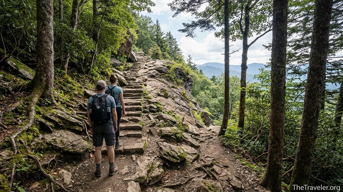
The Real Crux: From Arch Rock to the Bluffs
If there is a single part of Alum Cave that first-time hikers chronically underestimate, it is the section immediately after Arch Rock. Up to that point, the trail has been a shaded walk with gentle undulations and photogenic creek crossings. Arch Rock itself, where you climb stone steps through a narrow rock tunnel, feels like a fun attraction. Many people treat it as proof that “the hard part” is done. In reality, it is the gateway to the steeper heart of the hike.
Past Arch Rock, the trail tilts upward decisively. The surface turns more uneven, with rock steps, rooty stretches and brief, narrow segments where footing requires attention. This is also where the grade begins to feel sustained. Between Arch Rock and the landmark known as Inspiration Point, hikers gain several hundred feet in a short interval. Parents who were chatting easily by the creek often find themselves calling frequent “photo breaks” as their breathing catches up. It is very common to see people leaning on trekking poles or boulders, surprised by how rapidly their legs begin to burn.
One real-world example plays out almost every weekend in peak season. A visiting couple from Atlanta or Nashville arrives around 10:30 a.m., having been told by a hotel clerk that “Alum Cave is only about two miles.” They cruise through the cool lower forest in trail runners, take photos at Arch Rock, and assume they are nearly there. Fifteen minutes into the post-Arch Rock climb, the trail grows sunnier and steeper, and they suddenly confront the reality that they are less than halfway to the bluff in terms of effort. With no snacks, one small water bottle each, and a long drive back planned for that evening, they debate turning around even though they have not yet seen the famous view.
Even hikers pressing on to Mount LeConte feel the sting of this middle section. The total gain from trailhead to summit is around 2,700 to 2,800 feet, depending on the exact figure you reference, and a meaningful chunk of that begins right after Arch Rock. The trail has been restored in recent years to improve stone steps and drainage, but the fundamental steepness remains. For guests staying at LeConte Lodge who are carrying overnight gear, this is often the first big test of pacing and pack fit.
Exposure, Edges, and the Surprise of Cliffside Walking
Another often underestimated aspect of Alum Cave is not physical effort but psychological exposure. Past Inspiration Point, short stretches of the trail traverse slopes where the mountain drops away sharply. Although the path itself is generally wide enough for careful passing and is maintained with rock cribbing and hand cables in some sections, the sense of height can still be unnerving, particularly for those not used to mountain hiking.
For example, near the upper approach to Alum Cave Bluffs, the trail contours along Peregrine Peak’s flank. The outer edge falls away into the valley of Walker Camp Prong. In dry summer conditions, this is just a dramatic vantage point with expansive views. In shoulder seasons, when the rock can be damp or lightly icy, even a mild fear of heights can suddenly feel intense. Park guidance in winter often emphasizes traction devices precisely because people underestimate how exposed a misstep can feel on these sloping ledges.
First-timers who chose Alum Cave after strolling the flat paths around Cades Cove or the boardwalks near Sugarlands Visitor Center are sometimes startled to find themselves hugging a rock wall, asking oncoming hikers whether “it gets worse ahead.” The physical danger is usually low for cautious walkers, but the emotional strain of navigating drop-offs with children or a nervous partner can make this part of the hike feel much harder than the numbers on a trail sign suggest.
Real-world trip reports tell the same story. Families who are perfectly comfortable with a three-mile city greenway loop discover that their child’s mild fear of heights surfaces powerfully on the cliffside segments approaching the bluff. Parents end up coaxing a seven-year-old along each rocky outcrop, while also keeping an eye on faster hikers sliding by. That combination of exposure, crowding, and unfamiliar footing is what many later describe as “way more intense than the brochure made it sound.”
Weather, Crowds, and Timing: Invisible Difficulty Multipliers
Even when the terrain itself is well within a newcomer’s ability, conditions on Alum Cave can magnify the challenge in ways first-time visitors rarely anticipate. The National Park Service openly warns that the trail is subject to extreme crowding and very limited parking. On a typical Saturday in October or during spring break, cars may line Newfound Gap Road long before 9 a.m. Hikers who arrive late often spend 20 to 30 minutes working out where to park, then begin the trail frustrated and behind schedule.
Starting late also means hitting the steepest section in the day’s real heat. In July, the exposed stretches around Inspiration Point can feel dramatically hotter than the shaded creeks below. Humidity amplifies sweat loss, and many first-timers bring only a single small bottle of water purchased on the way through Gatlinburg. By the time they reach the bluffs, some are already semi-dehydrated and facing the downhill return through weekend traffic back to the trailhead.
Weather swings can catch visitors off guard as well. In shoulder seasons, a mild morning at the trailhead can give way to gusty, chilly conditions beneath the bluff, which sits near 5,000 feet. Mist and low cloud are common in the Smokies and can leave the rock underfoot slick. In winter or early spring, thin sheets of ice can linger on shaded rock steps and along the cable sections farther up the trail toward LeConte. Local outfitters often recommend microspikes for cold-weather attempts, but travelers who saw sunny photos in a brochure might underestimate how quickly conditions can turn treacherous on north-facing slopes.
Crowds themselves are another hidden difficulty. The very popularity that makes Alum Cave feel safe and social also produces congestion at bridge crossings, narrow ledges and scenic chokepoints like Arch Rock. It is not unusual on busy days to wait your turn to climb through the rock stairs or to shuffle single file along the bluff. For parents juggling kids or hikers carrying daypacks and photography gear, constant stopping and starting can be more tiring than a steady uphill walk on a quieter trail.
Gear, Food, and Fitness: What “Moderate” Really Demands
Trail descriptions often label the hike to Alum Cave as “moderate,” a word that means very different things to different travelers. In the Smokies, moderate usually assumes a base level of cardiovascular fitness and some familiarity with uneven terrain. Many first-time visitors interpret it as “I walk my dog around the neighborhood, so I am fine.” The reality is closer to climbing the stairs in a five-to-ten-story building, over and over, while carrying a small pack and occasionally stepping onto uneven stone.
Locally, outfitters in Gatlinburg and Townsend commonly steer beginners without hiking experience toward shorter routes like Laurel Falls or the quieter Cataract Falls near Sugarlands before graduating up to Alum Cave. The reason is simple: foot and ankle fatigue. Alum Cave’s rock steps and rooty stretches reward footwear with decent grip and some ankle support. Yet every busy weekend, you will see people starting this trail in flat canvas sneakers or fashion sandals. They may reach Arch Rock smiling, but as they tackle the steeper segments beyond, hot spots, rolled ankles and stubbed toes become far more likely.
Nutrition and hydration are also underestimated. A realistic plan for most adults is at least one liter of water per person for the hike to the bluffs and back in mild weather, and more on warm days. Simple snacks like trail mix, energy bars, or even a peanut butter sandwich help sustain energy on the longer climb. In practice, many first-timers bring a single half-liter bottle and no food, having just eaten a big breakfast in town. By the time they are descending those same stone steps, lightheadedness and shaky legs can turn a straightforward downhill walk into a slow, uncomfortable shuffle.
Finally, consider overall conditioning. Someone who sits at a desk all week and hops on an occasional treadmill may be surprised by how sustained uphill hiking taxes calves, quads, and small stabilizer muscles around the knees and hips. A few weeks before your trip, incorporating neighborhood hill walks, stair climbing in your office building, or weekend practice hikes in a nearby state park can turn Alum Cave from a daunting challenge into an enjoyable highlight of your Smokies visit.
Continuing to Mount LeConte: The Extra Miles Few Plan For
Another classic miscalculation on Alum Cave is what happens after the bluff. Many people treat the bluffs as the logical turnaround point, and for those hikers the most underestimated segment is that middle climb past Arch Rock. For a sizeable minority, however, Alum Cave is just the halfway marker on an ambitious day hike to Mount LeConte. For them, the underestimated element is distance and cumulative elevation gain.
From the trailhead to Mount LeConte’s summit area is roughly 5 to 5.5 miles one way, depending on the exact endpoint and route variations, with a total climb close to 2,700 to 2,800 feet. Many trip planners focus on the headline “shortest route to LeConte” and underestimate what that really means over a full day. A 10 to 11-mile mountain hike at sustained grades can easily take 7 to 9 hours for casual hikers, especially with stops at Alum Cave Bluffs, LeConte Lodge, Cliff Tops, or Myrtle Point for photos and rest.
Stories from LeConte Lodge staff and experienced hikers often involve guests arriving late in the day, surprised at how long the approach via Alum Cave took, particularly if they stopped for lunch beneath the bluff. On the descent, knee and hip fatigue kick in on the rock steps, especially for those without trekking poles. Hikers who did not pack headlamps sometimes find themselves racing dusk on the final miles through the forest, which can be unnerving on a trail already made slick by countless boots.
If you plan to continue past Alum Cave to LeConte, treat the bluff not as the scenic climax but as an early checkpoint. Check your watch, your water and food, and your group’s energy. Ask honestly whether you have both the daylight and stamina to handle another roughly 3 miles of often steeper, more exposed trail to the summit area and then the full descent. Building a realistic timeline, starting at or shortly after sunrise, and carrying an extra layer and headlamp are small decisions that can transform a strenuous push into a safe, memorable day.
How to Reframe Alum Cave So You Are Not Caught Out
Successfully hiking Alum Cave is less about being a seasoned mountaineer and more about expecting the right things from the right sections. If you think of the trail as three distinct chapters, it becomes easier to prepare. Chapter one is the gentle creek-side warm-up from the trailhead to Arch Rock. Chapter two, the part most underestimated, is the sustained climb from Arch Rock up past Inspiration Point to the base of Alum Cave Bluffs. Chapter three is either your scenic pause and descent from the bluff or, for those heading to LeConte, a transition to higher, cooler, more exposed terrain.
In practical terms, that means starting at a genuinely easy pace in the lower forest, even if the terrain feels trivial. Save conversation for the flatter segments and be prepared to shorten your stride on the steeper grades after Arch Rock instead of charging them. Schedule rest breaks in the shade before you feel desperate for them, especially if you are hiking with children or anyone less acclimated to hills.
It also helps to mentally downgrade the idea of Alum Cave as a “quick outing.” Treat it with the same seriousness you would give to any half-day mountain hike: proper footwear with traction, a small daypack with water, snacks, a light rain shell and a basic first-aid kit, and a check of the latest park alerts for weather, trail conditions, and bear activity. In peak season, plan to be at the trailhead parking area well before 8 a.m. to avoid the worst of the congestion and midday heat on the exposed middle miles.
Finally, set expectations in your group. Make sure everyone, from the most enthusiastic teen to the least keen family member, understands that the most demanding part of the hike is not at the beginning but in the middle, and that discomfort or nerves on the steeper, more exposed sections are normal. Agree in advance on turnaround times and non-negotiables such as keeping children inside the inner edge of narrow sections and stopping entirely when you need to pass oncoming hikers along ledges.
The Takeaway
Alum Cave’s popularity in Great Smoky Mountains National Park is well deserved. The trail packs old-growth forest, mountain streams, unique rock formations and sweeping views into a relatively short distance. For many visitors, it becomes the single most memorable experience of their trip. The very qualities that make it accessible, however, also set up first-time hikers to underestimate its crux: the sustained, steeper middle section between Arch Rock and the bluffs, amplified by exposure, crowds and sometimes volatile mountain weather.
If you approach Alum Cave as a genuine mountain hike rather than a casual walk, the surprises become manageable. Start early, move steadily, equip yourself as you would for any moderate backcountry outing, and be realistic about your group’s fitness and comfort with heights. Respect the effort concentrated into that underestimated middle stretch, and Alum Cave rewards you with cool rock corridors, dramatic cliff views and a satisfying sense of accomplishment. Whether you turn around beneath the towering bluff or continue on to Mount LeConte, reframing your expectations is the key to making this classic Smokies trail challenging in the best possible way.
FAQ
Q1. How long does it really take to hike to Alum Cave Bluffs and back?
For most first-time hikers, the 4.6 to 5-mile round trip takes about 3 to 4 hours including breaks and photos, especially once you factor in the steeper middle section after Arch Rock.
Q2. What part of the Alum Cave Trail do people underestimate the most?
The stretch immediately after Arch Rock up to and slightly beyond Inspiration Point is the most underestimated, because the grade steepens, footing becomes rockier, and modest exposure begins to appear, all after an easy-feeling first mile and a half.
Q3. Is the hike to Alum Cave considered suitable for beginners?
It can be suitable for reasonably fit beginners who are prepared for sustained uphill walking, uneven terrain, and some mild cliffside exposure. Those new to hiking should wear proper footwear, carry water and snacks, and be willing to turn around at Arch Rock if anyone in the group is struggling.
Q4. How much water should I bring for the hike?
A practical guideline for the hike to Alum Cave Bluffs in mild weather is at least one liter of water per adult, more in hot, humid conditions or if you are continuing on to Mount LeConte.
Q5. Are the exposed sections dangerous for people with a fear of heights?
The exposed sections near and above Inspiration Point are generally safe for cautious hikers, but they can feel intimidating if you are sensitive to heights. Many people manage them by walking on the inside edge, taking their time and pausing whenever other hikers need to pass.
Q6. What kind of shoes are best for the Alum Cave Trail?
Sturdy hiking shoes or lightweight boots with good traction are recommended. The steep, rocky steps and occasional wet or muddy patches make flat-soled sneakers, flip-flops and dress shoes a poor choice for this trail.
Q7. When is the best time of day to start this hike?
Starting early in the morning, ideally before 8 a.m., helps you find parking more easily, avoid the heaviest crowds at Arch Rock and the bluffs, and tackle the steeper middle section before the day’s heat builds.
Q8. Is it realistic to hike from Alum Cave to Mount LeConte in a day?
For fit, prepared hikers, a day hike from the trailhead to Mount LeConte and back, roughly 10 to 11 miles total, is realistic but strenuous. Plan for 7 to 9 hours on the trail, begin at sunrise, and bring extra food, water, layers and a headlamp.
Q9. What weather conditions make the trail more difficult?
High summer heat and humidity, lingering ice in winter and early spring, and wet, foggy days all increase the difficulty. Heat and humidity amplify fatigue on the steep climbs, while ice and wet rock make footing more precarious, especially on the exposed ledges.
Q10. Are there better options if I want an easier Smokies hike with views?
If Alum Cave sounds a bit beyond your comfort level, consider shorter or less steep options such as Laurel Falls, Gatlinburg Trail, or quieter creek-side walks near Sugarlands Visitor Center. You can enjoy classic Smokies scenery while building confidence before tackling Alum Cave another day.