
I meant for Alum Cave to be a warm-up hike. One moderate morning trek in Great Smoky Mountains National Park before tackling the “real” climbs around Mount LeConte. Instead, that supposedly casual outing turned into the trail I now recommend to every friend heading for the Smokies, the one I still think about when I picture perfect mountain days.
Get the latest updates straight to your inbox!
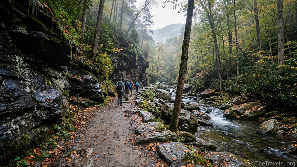
A Trail That Sneaks Up On You
Alum Cave Trail starts so gently that it hardly feels like one of the most celebrated routes in Great Smoky Mountains National Park. The trailhead sits along Newfound Gap Road, about 10 miles from Gatlinburg, Tennessee, with two paved parking lots that, on a typical June Saturday, are already filling by 7:30 a.m. The first half mile follows Walker Camp Prong, a clear mountain stream that sounds louder than the crowds, and the grade is forgiving enough that families in running shoes stroll alongside backpackers heading for the summit of Mount LeConte.
When I set out on my first hike here, my plan was modest: walk to Alum Cave Bluff, enjoy the view, and be back in Gatlinburg in time for a late lunch. Guidebooks and recent trail descriptions put the round-trip distance to the bluff at roughly 4.4 to 4.6 miles with about 1,100 feet of elevation gain, a moderate outing for anyone comfortable walking a few hours in the hills. It sounded like the ideal “ease into the park” day, sandwiched between driving mountain roads and checking into a cabin.
What those statistics do not capture is how steadily the trail builds character. After the first bridge crossings and a shaded stroll along Alum Cave Creek, the forest begins to close in, the path narrows, and the soft murmuring of the water grows into a consistent soundtrack. Every new bend seems to add another footbridge, another mossy boulder, another riffle of whitewater, until you realize you have been slowly falling in love with this valley without noticing.
By the time the trail starts to tilt in earnest, you are already invested. That is part of Alum Cave’s magic. It does not intimidate you at the trailhead. Instead, it lures you forward with small rewards and quiet details, saving the dramatic surprises for later.
Arch Rock: The First Real Surprise
Roughly 1.3 to 1.4 miles from the trailhead, the hike reveals its first unforgettable feature: Arch Rock. Here, the creek has carved a natural arch through a jut of dark rock, and the trail climbs stone steps right through its center. The National Park Service notes that these staircases were rebuilt by trail crews in 2015 and 2016, which helps explain why they feel secure underfoot even after heavy Smokies rainstorms.
On my first visit, a line of hikers formed at the base of the steps, each waiting for a chance to duck into the cool shade beneath the arch and snap a quick photograph. A family from Ohio, parents in their 50s with two teenagers, joked that it looked like an entrance to some fantasy kingdom. In reality it is the product of freeze-thaw cycles and erosion, a geologic story written very slowly, but the sense of stepping into something special is immediate.
Arch Rock is also where the trail shifts from “pleasant walk” to “real hike.” The grade steepens, switchbacks appear, and the forest opens just enough to hint at the heights above. On hot summer days, the temperature drops noticeably in the narrow gorge around the arch, and boots scuff gravel that still holds the previous night’s moisture. It is a good place to tighten your pack straps, take a long drink of water, and decide whether you want to keep pushing toward the views higher up.
Many casual hikers turn around here, making Arch Rock a rewarding destination on its own. For a visiting family with kids who are comfortable with two to three hours on the trail, getting to the arch and back offers a taste of everything that makes the Smokies compelling: water, rock, forest, and just enough effort to feel earned.
Inspiration Point and the Moment Alum Cave Won Me Over
Beyond Arch Rock, Alum Cave begins to show its hand. The forest thins in places, revealing glimpses of the ridges across the valley. Around 1.8 to 2 miles from the trailhead, you emerge at a spot known as Inspiration Point, perched near 4,700 feet. It is not a single lookout platform but a shoulder in the mountain, where the trail levels just long enough for your breathing to catch up with your legs.
This is where the hike first felt like something more than a warm-up. On that clear October morning, low clouds clung to Little Duck Hawk Ridge across the way while the sun slid between them, painting patches of forest in sharp light and leaving others in cool blue shadow. A pair of friends from North Carolina, clearly training for longer treks, pointed out toward Myrtle Point and Cliff Top on Mount LeConte and talked about coming back for sunrise and sunset on different days.
What struck me most was how accessible this moment felt. Reaching Inspiration Point requires effort, but not elite fitness. Recent trip reports from late 2025 describe hikers in their 60s reaching it in under two hours at a steady pace, pausing often to photograph the bridges and rock formations below. For visitors staying in Gatlinburg or Pigeon Forge, it is entirely realistic to drive to the trailhead after breakfast, hike to Inspiration Point and Alum Cave, and still be back in town by mid-afternoon.
Standing there, watching the light shift across the ridges, I realized Alum Cave had already delivered more than some full-day hikes in other parks. Yet the best part of the trail was still ahead.
Alum Cave Bluff: Not Really a Cave, Definitely a Destination
Alum Cave itself arrives not long after Inspiration Point, around 2.2 to 2.3 miles from the trailhead. The name is a bit misleading. This is not a deep cavern with hidden chambers, but a massive, 80-foot-tall rock overhang that arcs out from the slope like a stone wave. The ground beneath is sandy, stained dark in places from mineral deposits, and the opening frames a sweeping view down the valley.
On my first visit, mid-morning temperatures had climbed into the low 60s, but the air under the overhang was cool and dry. Hikers rested with their backs against the wall, boots off, sharing trail mix and swapping stories about favorite routes in other national parks. One couple from Florida, who had flown into Knoxville on a budget airline and rented a compact car for the week, said they had chosen Alum Cave specifically because recent online reviews described it as “the one Smokies trail to do if you only have time for one hike.” After a short break, they decided to turn back here, satisfied with the effort and the view.
In winter, photographs and reports from local hikers show the bluff transformed by long curtains of icicles clinging to the rim. In summer, the overhang becomes welcome shelter from sudden Smokies thunderstorms, though rangers caution visitors to move away from the cliff edge during lightning. Whatever the season, it is a natural gathering place. For many visitors, this is the turnaround point, an out-and-back of about 4.5 miles that checks all the boxes: unique geology, forest walking, mountain vistas, and a sense of accomplishment without committing to a full-day ascent of Mount LeConte.
For me, it was also the exact moment the trail shifted from “a good hike” to “my favorite in the park.” The combination of that sandy amphitheater, the layered ridges rolling away into the distance, and the hum of conversations in half a dozen accents felt like the Smokies at their best: wild enough to feel remote, accessible enough to welcome almost anyone.
Continuing Toward Mount LeConte: Where Casual Becomes Committed
From Alum Cave Bluff upward, the character of the trail changes again. The crowds thin quickly. The path grows steeper and, in several places, traverses narrow ledges where steel cables bolted into the rock serve as handholds. Hikers continuing beyond the bluff commit to a different kind of day, one that can easily stretch to eight hours or more for the full out-and-back to the summit of Mount LeConte.
Recent hiking guides peg the full distance from Alum Cave trailhead to LeConte’s high point at roughly 11 miles round trip with more than 2,700 feet of elevation gain. That makes it a strenuous undertaking, particularly for visitors who live at low elevations. One TripAdvisor review from December 2025 describes a group that planned only to reach the bluff, then kept going to Gracie’s Pulpit, the halfway marker to the summit, before wisely turning around when legs began to protest.
Part of why Alum Cave has become my favorite trail is that it offers such clear “chapters.” You can hike to Arch Rock and make it a gentle half-day adventure. You can push on to Inspiration Point and the bluff for a moderate, immensely rewarding hike. Or, if you are properly prepared with layers, headlamps, food, and plenty of water, you can continue all the way to the high country, spending time at LeConte Lodge before making the long descent.
On my third time up Alum Cave, I joined the committed group. We started from the lower parking lot before sunrise, our headlights bobbing along the creek, and reached the summit by late morning, just as clouds began to drift in from the west. That day cemented the trail’s hold on me: the way it moves from creekside forest to rock corridors, from sheltered bluff to high, wind-brushed spruce-fir stands, feels like a full tour of the Smokies in one continuous line.
Practical Tips That Make the Hike Better
Part of turning a memorable trail into a favorite one is learning how to hike it well. Alum Cave’s popularity means planning matters. Even in shoulder seasons, parking lots can fill by mid-morning. In 2026, Great Smoky Mountains National Park continues to require paid parking tags for vehicles parked more than 15 minutes, which visitors can purchase in Gatlinburg, at visitor centers, or at self-serve kiosks near busy areas. Having that tag on your dashboard avoids a scramble at the trailhead.
Timing helps, too. On my first hike, I arrived around 8:00 a.m. on a weekday in October and found a space in the lower lot; by the time I returned early afternoon, drivers were circling and walking in from roadside pullouts. Locals I spoke with recommend starting even earlier in peak summer, especially on Saturdays, both to secure parking and to enjoy the cooler morning temperatures on the steeper upper sections.
Gear choices can make the difference between a casual hike and a grueling one. The lower part of the trail feels friendly enough for sneakers, but the rocky, often damp segments around Arch Rock and the ledges above Alum Cave Bluff strongly favor proper hiking shoes with good traction. Trekking poles are optional to the bluff but highly recommended if you plan to continue toward Mount LeConte, where long descents can be hard on knees. Because cell service is unreliable, printed or downloaded maps from visitor centers remain useful, even on such a well-signed route.
Weather flexibility is essential. Conditions on Newfound Gap Road do not always match those on the trail. In late spring and fall, hikers often start in Gatlinburg wearing short sleeves, then pull on fleece layers near Inspiration Point as winds pick up. In winter, recent reports have mentioned patches of ice along the cable sections, making microspikes or similar traction devices a wise addition. When storms move in, rangers encourage turning around at the bluff or earlier rather than pushing higher into exposed terrain.
Why Alum Cave Keeps Pulling Me Back
Every national park seems to have at least one “signature” hike that locals love but worry will feel overhyped to visitors. In the Smokies, Alum Cave is often that trail. After several visits, I have come to understand why it remains worth the attention. It is not just the headline features like Arch Rock or the dramatic sweep of the bluff. It is the way the entire route flows together, packing so much variety into a single ascending valley.
On one spring hike, I watched a trail crew clearing drainage ditches near the lower bridges, part of the ongoing maintenance that has kept this once-eroded path in excellent shape since a major rehabilitation project wrapped up in 2016. Seeing that work in person, muddy and methodical, made me appreciate why the steps feel solid and the tread stays surprisingly smooth even after heavy use. The trail’s popularity, instead of being a drawback, has helped secure the attention and resources it needs to handle thousands of boots each season.
There is also something about the social energy on Alum Cave that I have grown to enjoy. At the bluff on a busy Saturday, you might hear a group from Chicago comparing it to hikes in Shenandoah, a solo traveler from Texas asking for directions to Myrtle Point, and a local from Sevierville offering weather advice for the rest of the week. Yet, only a short walk beyond that gathering spot, the crowds thin and the forest quiets. The trail gives you both community and solitude, depending on how far you want to go.
Ultimately, Alum Cave became my favorite trail in the park not because it is the most remote or the most difficult, but because it shows what the Smokies do best in such a compact, approachable way. It is the hike I can recommend to a first-time visitor with only one free day and the one I still choose when I want to feel the full arc of a mountain day without poring over maps for hours.
The Takeaway
What began as a casual plan to stretch my legs before bigger objectives turned into a long-term attachment to one particular path. Alum Cave Trail has a way of surprising you like that. It starts softly, builds steadily, and then delivers cliffside vistas and high-country options without ever losing the friendly, social spirit of a beloved national park route.
If you are heading to Great Smoky Mountains National Park in 2026, Alum Cave remains an essential experience. Whether you stop at Arch Rock, linger under the bluff, or continue toward Mount LeConte, you will walk through a living gallery of the park’s best qualities: tumbling creeks, deep forests, weather-sculpted stone, and the kind of views that stay with you long after you have left the mountains behind.
Pack a parking tag, sturdy shoes, and more water than you think you will need. Start early, move at a pace that lets you notice the details, and give yourself time at Alum Cave Bluff simply to sit and look out over the ridges. With a little planning and a flexible schedule, that “casual hike” might just become your favorite trail in the Smokies too.
FAQ
Q1. How long is the hike to Alum Cave Bluff and how difficult is it?
The hike from the trailhead to Alum Cave Bluff is roughly 4.4 to 4.6 miles round trip with about 1,100 feet of elevation gain, generally considered a moderate hike for reasonably active visitors.
Q2. How early should I arrive to find parking at the Alum Cave trailhead?
In busy seasons, especially weekends from late spring through fall, it is wise to arrive by 7:30 a.m. or earlier. By mid-morning, both main parking lots along Newfound Gap Road often fill and drivers may have to wait for spots to open.
Q3. Do I need a permit or pass to hike Alum Cave Trail?
There is no separate hiking permit for Alum Cave, but Great Smoky Mountains National Park does require a paid parking tag for vehicles parked more than 15 minutes anywhere in the park.
Q4. Is Alum Cave Trail suitable for children and beginners?
Many families hike at least to Arch Rock and often to Alum Cave Bluff. Children and beginners who are comfortable walking a few miles with some uphill sections typically manage the lower portions well, but the upper trail toward Mount LeConte is best left to more experienced or well-prepared hikers.
Q5. What is the best time of year to hike Alum Cave?
Late spring through fall offers the most reliable conditions, with wildflowers in spring, lush greenery in summer, and colorful foliage in October. Winter can be beautiful but often brings ice and snow, especially above the bluff, which requires extra caution and traction devices.
Q6. Can I continue from Alum Cave Bluff to the summit of Mount LeConte in one day?
Yes, many hikers make the roughly 11-mile round trip to Mount LeConte and back via Alum Cave in a single day, but it is a strenuous outing. Plan on six to ten hours depending on pace, carry plenty of food and water, and start early.
Q7. Are there bathrooms or water sources along the trail?
There are restrooms near the trailhead parking area but none along the trail itself. Streams cross the route, but water should be treated before drinking, and most day hikers prefer to carry enough water from the start.
Q8. How exposed or narrow are the ledges above Alum Cave Bluff?
Sections of trail above the bluff cross narrow rock ledges with steel cables anchored into the wall as handholds. Many hikers with mild exposure concerns manage them without trouble, but anyone uncomfortable with heights may prefer to turn around at the bluff.
Q9. What gear do you recommend for a day hike to Alum Cave Bluff?
Sturdy hiking shoes with good traction, a small daypack, at least one to two liters of water per person in warm weather, snacks, layered clothing, and a lightweight rain jacket are sensible basics. Trekking poles are optional but helpful on the steeper, rockier sections.
Q10. Is Alum Cave Trail crowded, and how can I find more solitude?
The lower trail is popular and often busy, especially on weekends and holidays. To experience quieter moments, start at sunrise, visit on a weekday outside peak season, or continue beyond Alum Cave Bluff toward Mount LeConte, where the crowds thin significantly.