
More news on this day
Strong late-weekend thunderstorms rolling through the Washington region have triggered extensive flight delays across all three DC area airports, disrupting travel plans at the outset of the busy summer season.
Get the latest news straight to your inbox!
Storms Sweep the Capital Region During Peak Travel Window
A hot, humid air mass over the Mid-Atlantic collided with an advancing cold front Sunday evening, setting off a line of thunderstorms that moved across the Washington metropolitan area. Weather outlets tracking the system described damaging winds, torrential rain and frequent lightning as the primary hazards, with the greatest thunderstorm risk centered on the late afternoon and evening hours.
Regional forecasts indicated that storms would develop rapidly after a day of intense heat, with temperatures climbing into the 90s across the District and nearby suburbs. As the convective line expanded, the Washington area remained under a severe thunderstorm watch into the late evening, and rainfall rates were high enough in some cells to briefly reduce visibility to near-zero conditions around the Potomac corridor.
Specialized storm outlooks highlighted the Mid-Atlantic, including the nation’s capital, as part of a broader corridor of severe weather stretching from the Northeast into portions of the Southeast. The setup raised early concerns that any organized thunderstorm clusters would intersect major air corridors feeding into the Washington region’s three commercial airports.
By nightfall, publicly available observations showed the strongest storms pushing east and southeast of the District, but lingering showers, low clouds and residual lightning kept operations constrained and forced airlines to adapt schedules in real time.
Ground Stops and Delays Hit Reagan National, Dulles and BWI
Operations at Ronald Reagan Washington National Airport were among the first in the region to feel the impact, with a combination of low ceilings, lightning in the vicinity and turbulent cells along departure and arrival routes prompting air traffic managers to meter traffic. Recent accounts from travelers noted that National has faced frequent ground stops and ground delay programs during thunderstorm events this season, particularly when storm clusters align with busy afternoon departure banks.
While updated delay statistics for the latest storms were still shifting overnight, earlier June events offer a sense of scale. During a recent severe thunderstorm outbreak, publicly available airline performance snapshots indicated that more than one third of departures at Reagan National were delayed and roughly a third cancelled over the course of a single day, as weather-sensitive routes along the East Coast were repeatedly pushed back or scrubbed.
Washington Dulles International and Baltimore/Washington International Thurgood Marshall also saw their evening operations slow as the line of storms crossed northern Virginia and central Maryland. Arrival rates into the region’s airspace were reduced to accommodate reroutes around the heaviest cells, and the risk of lightning near ramp areas periodically halted ground handling, compounding taxi and gate delays.
Data made available through air traffic management advisories and airline communications showed that some carriers proactively thinned schedules or held aircraft at origin airports when convective forecasts deteriorated, deepening delays but reducing the likelihood of last-minute cancellations after passengers had already boarded.
Airlines Activate Weather Waivers as Summer Disruption Builds
In anticipation of the stormy pattern, multiple major carriers issued flexible travel waivers covering Washington-area airports, allowing affected passengers to change flights within a specified window without additional fees. Publicly posted waiver details highlighted Washington National and Washington Dulles among a broader list of East Coast airports expected to see thunderstorms and possible ground delay programs through the middle of June.
The waivers followed a series of early-summer weather disruptions that have already exposed pressure points in airline operations. Recent coverage of a severe storm event at Reagan National described how one large carrier’s emphasis on digital-only customer service left some passengers struggling to rebook via apps and QR codes while lines grew at closed or lightly staffed counters. That earlier episode, tied to thunderstorms and air traffic constraints, prompted renewed scrutiny of how airlines communicate during rapidly evolving weather events.
Industry performance analyses from the spring of 2026 show that nationwide thunderstorms can quickly cascade into thousands of delays and cancellations when major hubs and congested corridors are affected simultaneously. The Washington region sits at the intersection of several of those corridors, meaning that storms over the Mid-Atlantic can have disproportionate impacts on both local and connecting passengers.
With Sunday’s storms arriving on a weekend framed by large events and peak leisure demand, airlines in the DC area appeared to lean heavily on preemptive schedule adjustments, rolling delays and change-fee waivers in an effort to manage capacity and reduce the number of travelers stranded overnight in terminals.
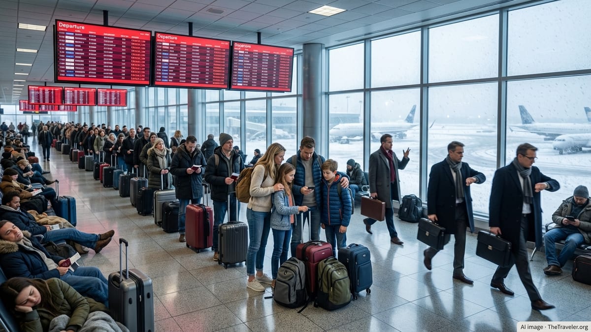
Passengers Face Long Waits, Missed Connections and Crowded Terminals
For travelers, the immediate effects of the thunderstorms were evident in stretched-out departure boards, repeated gate changes and mounting lines at service desks. Social media posts and traveler forums on Sunday referenced delays of 30 minutes extending to an hour or more at Reagan National as successive weather holds were issued, while some earlier flights during the unsettled period were ultimately cancelled for weather after multiple rolling delays.
At Dulles and BWI, passengers reported extended time on aircraft awaiting takeoff clearance as air traffic control slowed departure flows to keep aircraft out of the most active storm cells. For some routes, especially shorter East Coast hops, airlines opted to cancel later frequencies and rebook customers on the next morning’s departures, resulting in unexpected overnight stays and competition for nearby hotel rooms.
These local accounts fit a broader national pattern of summer storm disruption, where even brief episodes of severe weather can create an hours-long backlog of flights. When storms coincide with peak demand days, gate space becomes scarce and inbound aircraft may be held at origin, producing knock-on effects that reach far beyond the immediate storm zone.
Publicly available consumer travel guidance continues to emphasize basic resilience strategies for days like these, including booking earlier departures when possible, traveling with essentials in carry-on bags and monitoring both airline apps and airport status pages closely as conditions evolve.
More Storms Possible as Summer Pattern Sets In
Meteorologists tracking the broader pattern indicate that the latest round of thunderstorms is part of a larger early-summer regime favoring repeated convective outbreaks along the East Coast. Forecast discussions point to additional days this week with the potential for afternoon and evening thunderstorms in and around the nation’s capital, although the exact timing and intensity remain uncertain.
Weather outlooks published for the Mid-Atlantic highlight a continued risk of damaging wind gusts, heavy downpours and frequent lightning, particularly when daytime heating overlaps approaching frontal boundaries or upper-level disturbances. Even when storms are relatively short-lived, their interaction with tightly scheduled air traffic windows can be enough to generate fresh rounds of delays.
Travel analysts note that, with peak summer now underway, the cumulative effect of repeated weather events may be as disruptive as any single outbreak. Each day of thunderstorms forces airlines, airports and passengers to recalibrate, and residual aircraft and crew imbalances can linger for several operating days after the skies clear.
For those planning travel through Washington’s airports in the coming days, publicly available forecasts and air traffic status tools suggest that flexibility will remain key. Monitoring storm risk, leaving extra time to connect and considering alternative routings when severe weather is in the outlook may help reduce the odds that the next wave of thunderstorms turns a short hop into an extended ordeal.