
Europe is full of famous rivers, from the broad Danube to the romantic Seine and the working Thames. Yet the Arno River in Tuscany has a very different personality. It cuts a relatively modest path across central Italy, but along its banks rose two of Europe’s most influential cities: Florence and Pisa. For travelers, the Arno feels less like a scenic backdrop and more like a living character that has repeatedly threatened, shaped, and ultimately helped define the culture, architecture, and daily life of Tuscany.
Get the latest updates straight to your inbox!
A Small River With an Outsized Cultural Footprint
The Arno is not one of Europe’s great giants by the numbers. Stretching around 240 kilometers from Monte Falterona in the Apennines to the Ligurian Sea near Pisa, it is far shorter than the Rhine or Danube and even smaller than Italy’s Po. Yet along this compact course, the Arno threads together landscapes that range from forested uplands to tight Tuscan valleys and, finally, a flat coastal plain. That variety is immediately visible if you travel by train between Florence and Pisa and watch vineyards, stone villages, and industrial zones alternate along the river corridor.
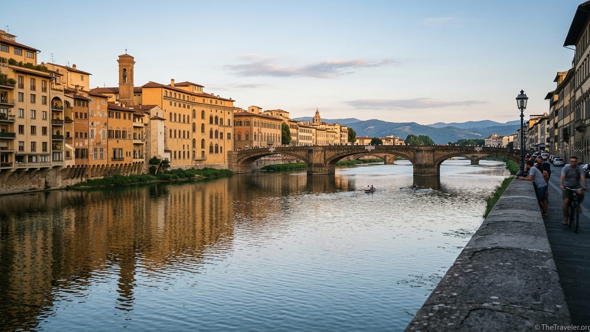
What sets the Arno apart is the density of cultural heritage along its middle reach. In Florence, it flows under Ponte Vecchio and past the Uffizi and Palazzo Vecchio, essentially bisecting a UNESCO-listed historic center. In Pisa, it curls around medieval streets and university colleges before widening toward the sea. Many celebrated European rivers run through capitals, but few pass quite so close to such a concentration of Renaissance art and architecture in such a confined space.
For travelers, that concentration means the river is always in view. In Florence, hotel rooms on the lungarni, cafés with outdoor tables, and evening passeggiate all orient toward the water. Unlike the Seine in Paris, which you can ignore if you stay inland, the Arno repeatedly reappears as you cross narrow streets, climb church steps, or peer down alleys toward a sudden strip of glittering water.
A River That Both Built and Nearly Destroyed Florence
No other European art city has a relationship with its river as fraught as Florence’s with the Arno. Over centuries, the river helped finance local wealth by powering mills, irrigating fields in the Valdarno, and serving as a transport route for timber and agricultural goods. That prosperity funded the Medici and the patrons who commissioned the domes, palaces, and paintings visitors admire today.
Yet the same river repeatedly turned violent. The most notorious episode came on November 4, 1966, when days of intense rain sent a surge of water and mud through Florence. Water levels in parts of the historic center reached several meters high, submerging streets around Santa Croce and the National Central Library. Thousands of artworks and rare books were damaged in museums and churches close to the river. The catastrophe became a defining event in modern conservation, as international volunteers, sometimes called the “mud angels,” rushed in to rescue soaked canvases and manuscripts.
Travelers today still see physical reminders of that day. Plaques on walls around Santa Croce, via dei Neri, and other streets mark the level the water reached in 1966, often well above head height. Standing beneath them, with the river apparently calm a few blocks away, gives a visceral sense of the Arno’s force. By contrast, major European rivers like the Seine or Thames have also flooded, but their disasters rarely intersected with such a dense concentration of world-famous cultural treasures in such a small area.
Following the flood, authorities deepened parts of the riverbed in Florence, reinforced the stone embankments known as the lungarni, and adjusted bridge structures to reduce the risk of backwater effects. Walking today along Lungarno degli Acciaiuoli or Lungarno delle Grazie, you can see massive retaining walls and parapets that function as both scenic promenades and defensive works. In Florence, the Arno is not just picturesque waterfront; it is an engineered channel designed with hard-earned caution.
Engineering a Temperamental Tuscan Waterway
Another feature that makes the Arno different is how heavily it has been reshaped compared with many other European rivers. Upstream from Florence, reservoirs and basins regulate part of its flow, while downstream near Pisa, an artificial flood-channel, the Scolmatore dell’Arno, was built in the mid-20th century to divert excess water away from the city toward the sea. Some of this infrastructure was finished only after the 1966 disaster, and it still forms part of Tuscany’s flood management strategy today.
For visitors, this engineering is not just an abstract fact. Riding the regional train from Pisa to Florence, you may notice long straightened stretches and embankments that do not look entirely natural. Near Pontedera, the river becomes a managed corridor flanked by levees and industrial parks rather than a wild floodplain. Unlike the romantic meanders of the upper Danube or the Loire, the lower Arno in particular feels like a working system whose shape is dictated by risk control as much as by geography.
In Florence, the lungarni embankments double as public spaces. At sunset, students perch on the stone walls with takeaway aperitivi, while cyclists use the flat riverfront as a practical east-west route across the city. This close coexistence between everyday life and heavy-duty flood defense is striking. In Paris or London, major flood works are often hidden behind parks or wider quays. In Florence, you are literally sitting on the barrier that stands between the historic center and another catastrophic inundation.
Similar stories play out in Pisa, where the Arno’s tendency to shift course and deposit sediment once created marshes and a coastal lagoon. Over centuries, drainage projects and canals transformed that landscape into agricultural land and suburbs. When you stroll along Pisa’s central riverfront, you are walking on land that exists in its current form only because of long-term attempts to discipline an unruly river.
Not a Grand Shipping Highway, but a Local Lifeline
One of the most obvious differences between the Arno and other European rivers is its modest role in large-scale navigation. While the Rhine and Danube carry commercial barges across borders, and even the Seine and Thames still see significant freight traffic, the Arno today is largely a local river. Its variable flow, relatively shallow stretches, and tight bends near Florence and Pisa make it unsuitable for big ships.
Historically, small boats moved goods such as grain, timber, and stone along parts of the Arno, contributing to Florence’s medieval economy and Pisa’s status as a maritime power. Over time, however, railways, roads, and changes in the river’s morphology reduced the importance of waterborne trade. By the 20th century, large segments of the Arno were no longer practical for serious commercial navigation.
For modern travelers, this has two visible consequences. First, the Arno often feels quieter than major European waterways. In Florence, you are more likely to spot a small rowing club gliding past the Uffizi or a private sunset cruise operating near Ponte Vecchio than a cargo barge. Tour operators sometimes advertise short evening boat rides, typically in small traditional-style craft, focusing on views of bridges and palazzi rather than on a long river journey. Second, the absence of heavy shipping means the waterway is less industrial in character, especially in city centers, than the Rhine in Cologne or the Danube in Vienna.
This local focus is also reflected in recreational use. The Arno has pockets where rowing, kayaking, and small-boat training are common, particularly upstream of Florence or in calmer stretches near Pisa. Visitors walking the riverbanks might notice modest boathouses, slipways, and club flags, emphasizing that this is primarily a community river rather than a continental artery.
From Ponte Vecchio to Pisa’s Palaces: Architecture Hugging the Water
Architecturally, the Arno’s urban stretches stand out from many other European rivers. In Florence, buildings often stand extremely close to the water’s edge, with the narrow medieval street grid running almost directly into the river. Ponte Vecchio is the most famous symbol of this intimacy. The bridge, topped with a continuous row of jewelry shops and workshops, projects out over the river in a way rarely seen in other European cities, where bridges tend to be purely structural and left visually uncluttered.
Walking from Piazza della Signoria toward the Arno, you emerge onto Lungarno degli Acciaiuoli and suddenly find the river almost at your feet, with Ponte Vecchio rising ahead. The effect is very different from cities where modern traffic routes or broader parks separate the historic core from the water. Here, the river feels like an extension of the main civic space, not a boundary on its edge.
Pisa presents another variation of this close riverfront urbanism. Its pastel palaces and university buildings line both sides of the Arno, some with entrances directly off the riverside streets. Although most visitors head straight to the Leaning Tower and the nearby cathedral complex, a stroll along the central lungarni reveals an almost theatrical façade of townhouses and civic buildings reflected in the water. In the evening, when lights come on in upper-floor windows and the water darkens, the reflections are particularly striking.
In contrast, many larger European rivers pass through broader floodplains, so historic architecture often sits further back. The Arno’s relatively narrow valley and long history of riverbank construction have produced cityscapes where the separation between stone and water is minimal, visually and physically.
Water Quality, Swimming, and Everyday Use
Travelers sometimes imagine jumping into the Arno on a hot summer day, but local attitudes are more cautious. Like many urban rivers, the Arno has a history of pollution from industry, agriculture, and untreated wastewater, particularly in the 20th century. While treatment plants and regulations have improved water quality compared with several decades ago, it is still not considered a casual swimming spot in central Florence or Pisa. Local authorities periodically issue guidance or restrictions, and many residents will tell you that swimming in the urban stretches is unwise.
That said, the situation is not uniform along its entire length. Upstream of Florence, near reservoirs and smaller tributaries, locals use lakes and cleaner sections of the river basin for summer recreation. A practical example for travelers is Lago di Bilancino, a man-made lake in the Arno basin north of Florence, where beaches and water sports centers operate legally under controlled conditions. Here you are experiencing the broader Arno system, even if not the main river through the city.
This patchwork reality contrasts with some other European rivers, where central stretches are famous for organized swimming. The Rhine in Basel or the Aare in Bern, for instance, are promoted for supervised river swims, with infrastructure such as lockers and lifeguards. The Arno has nothing comparable in Florence or Pisa. Its hydrology, water quality, and urban form combine to make it more of a river to walk beside and look at than to dive into.
For visitors, that means planning river-related activities around views and walks rather than bathing. Popular choices include golden-hour strolls along Lungarno Corsini in Florence or sitting on the low steps near Ponte Santa Trinita to watch the sky turn pink behind the hills to the west. In Pisa, outdoor cafés on the riverfront offer good spots to watch the changing light reflect in the Arno before heading back toward the cathedral square after dark.
The Arno’s Role in Modern Tuscan Life
Although the Arno no longer dominates transportation in Tuscany, it still shapes everyday life in ways visitors can easily notice. Local news occasionally focuses on high water levels, maintenance on dams or flood channels, or debates about the aesthetics of riverbank restorations. Recent works on Florence’s embankment walls, for instance, sparked discussions among residents about whether new coatings looked too bright compared with the historic stone, a reminder that the riverfront is both infrastructure and shared civic space.
Water management projects elsewhere in the Arno basin can also affect daily routines. Maintenance or upgrades to water supply systems related to the river have, at times, required temporary shutoffs for parts of Florence and surrounding municipalities. For locals, the Arno is not just a view; it is part of an interconnected system that underpins tap water, agriculture, and flood safety.
Seasonally, the river’s color and mood change dramatically. In late winter and early spring, heavy rains can turn it fast and brown, with swirling debris and visibly higher levels at the base of bridges. In summer, especially after dry spells, it often appears slower and greener, with more exposed stone along the banks. Photographers lingering near Ponte alle Grazie or the bridges in Pisa will notice how drastically the reflections and textures shift from month to month.
Compared with Europe’s more heavily touristic rivers, there are fewer large-scale commercial cruises or standardized sightseeing circuits on the Arno. This leaves room for smaller, often locally run experiences, from rowing regattas in Florence to temporary floating platforms used for events. When planning a trip, it is worth checking local cultural calendars and city-led initiatives, which sometimes include concerts or installations that use the river as a backdrop.
The Takeaway
What makes the Arno River different from other famous European rivers is not its length, volume, or commercial power, but its intense, sometimes uneasy intimacy with the cities along its banks. It is a relatively small, temperamental waterway that has repeatedly challenged Florence and Pisa, even as it helped create the wealth and conditions that made their cultural achievements possible.
For travelers, that translates into a river experience that feels closer and more personal than the grand, heavily trafficked corridors of the Rhine or Danube. You do not board a week-long cruise on the Arno; instead, you walk beside it, cross it again and again on stone bridges, and read the high-water marks on medieval walls. You see how engineering works, civic debates, and small local rituals continue to revolve around this narrow band of water.
Spending time along the Arno, especially in Florence and Pisa, offers a chance to understand how a modest river can shape a region’s identity as powerfully as any of Europe’s bigger waterways. It is a reminder that in Tuscany, as in many places, the most influential forces are not always the largest, but the ones that flow closest to everyday life.
FAQ
Q1. Can you take a river cruise on the Arno like on the Danube or Rhine?
Short sightseeing boat trips exist in Florence and occasionally in Pisa, but there are no long-distance cruise ships comparable to those on the Danube or Rhine. Most experiences are short, local excursions focused on city views.
Q2. Is it safe to swim in the Arno River in Florence or Pisa?
Swimming is generally discouraged in the urban stretches because of variable water quality, currents, and boat traffic. Locals prefer nearby lakes and regulated swimming areas in the wider Arno basin instead of jumping into the river in the city center.
Q3. Why is the 1966 Arno flood still talked about so much?
The November 1966 flood severely damaged Florence’s historic center, affecting churches, museums, and the National Central Library. It became a turning point in modern conservation and left visible marks on the city, such as high-water plaques that travelers can still see today.
Q4. How does the Arno compare in size to other European rivers?
The Arno is relatively short and modest in flow, especially compared with rivers like the Danube, Rhine, or even Italy’s Po. Its significance comes less from size and more from the cultural and historical importance of the cities along its banks.
Q5. Are there walking paths along the Arno for visitors?
Yes. In Florence, the lungarni on both sides of the river offer continuous pavements for walking, with frequent bridge crossings and river views. Pisa also has pleasant riverside promenades lined with historic buildings and cafés.
Q6. Does the Arno still pose a flood risk to Florence and Pisa?
Yes, but the risk is mitigated by dams, diversion channels, and reinforced embankments. Authorities monitor conditions closely during heavy rain. High water events still attract local attention, but modern infrastructure aims to prevent a repeat of the 1966 catastrophe.
Q7. What is the most scenic spot along the Arno for sunset in Florence?
Many visitors favor the view from or near Ponte Santa Trinita, looking toward Ponte Vecchio and the western hills, or from the lungarni on the Oltrarno side. These spots offer classic river reflections and silhouettes of bridges and palaces at golden hour.
Q8. Does the Arno reach the sea, and can travelers visit its mouth?
Yes. The Arno flows into the Ligurian Sea near Marina di Pisa. Travelers can easily reach this small seaside area from Pisa by bus or car to see where the river widens and meets the coast.
Q9. Why does the water in the Arno sometimes look brown or muddy?
Heavy rain in the Apennines can wash sediment and debris into the river, turning it brown and opaque. This is especially common in late autumn and winter, when flows are higher and the river runs faster through Florence and Pisa.
Q10. Are there any traditional festivals linked to the Arno River?
Yes. Both Florence and Pisa host events and regattas that use the river as a stage. Dates and formats vary, but rowing competitions, historical reenactments, and evening riverfront celebrations periodically bring locals and visitors together along the banks.